Cors Caron

Last updated

Cors Caron
Afon Teifi a Cors Caron, Ceredigion.jpg
River Teifi and Cors Caron from Pont Einon
Location Ceredigion, Wales
Coordinates 52°14′05″N3°56′53″W / 52.234698°N 3.947980°W / 52.234698; -3.947980
Governing body Natural Resources Wales

Cors Caron is a raised bog in Ceredigion, Wales. Cors is the Welsh word for "bog". Cors Caron covers an area of approximately 349 hectares (862 acres). [1] Cors Caron represents the most intact surviving example of a raised bog landscape in the United Kingdom. [2] About 44 different species groups inhabit the area including various land and aquatic plants, fish, insects, crustaceans, lichen, fungi, terrestrial mammals and birds. [2]

Contents

History

The boardwalk leads across the bog. It is for the use of permit holders only as it leads across a treacherous area. Cors Caron, Boardwalk.jpg
The boardwalk leads across the bog. It is for the use of permit holders only as it leads across a treacherous area.

Cors Caron began to be formed 12,000 years ago, at the end of the last glacial period. A raised bog of this type develops from a lake or flat marshy area, over either non-acidic or acidic substrates. Over centuries there is a progression from open lake, to marsh and then fen (or on acidic substrates, valley bog), as silt or peat fill the lake. Eventually, peat builds up to a level where the land surface is too flat for ground or surface water to reach the centre of the wetland. Trees in the area that died (in about 3000 BC) and were preserved by the conditions in the bog are being studied by scientists looking for information on the past climate of the area. [3]

For many centuries the peat in bogs was cut out and harvested for use as a heating fuel. Many bog ecosystems were completely destroyed by this practice. As a result of international concern, Cors Caron was designated as a national nature reserve in 1955. [4] Formerly in the ownership of the Trawsgoed Estate, and the Earl of Lisburne, the bog is located in the 2,000-acre (8.1 km2) Cors Caron National Nature Reserve. In 1956, the 7th Earl of Lisburne entered into a management agreement with the Nature Conservancy Council, and the reserve lands were sold to the Countryside Council for Wales in 1986. The estate retains grazing and sporting rights over some 700 acres (2.8 km2) of the reserve and adjoining farmland. On 2 September 1992, Cors Caron was put on a list of wetland sites of international importance under the Ramsar Convention. [5] The bog is now maintained by Natural Resources Wales, successor body to the Countryside Council for Wales. [6]

General site characteristics

Primary habitats (priority) feature

The assessment designated the primary feature for the selection of Cors Caron as active raised bog described as:

The Cors Caron sequence of peat domes (also known as Tregaron Bog) developed on the floodplain of the Afon (River) Teifi in mid-Wales now represents the most intact surviving example in the UK of a raised bog landscape (macrotope). The three main extant domes are hydrologically isolated by the River Teifi and associated surface drainage features, and all three have suffered extensive damage as a consequence of past drainage and peat-cutting. The river terraces associated with the component bog mesotopes are regularly flooded and support vegetation that includes reed canary-grass Phalaris arundinacea, soft rush Juncus effusus, purple moor-grass Molinia caerulea and, more rarely, water sedge Carex aquatilis. Substantial areas of the surface of each of the three component bogs still retain good quality active raised bog vegetation mainly referable to NVC type M18 Sphagnum papillosum – Erica tetralix community, with frequent bog-rosemary Andromeda polifolia and white beak-sedge Rhynchospora alba and, more locally, the bog-mosses Sphagnum magellanicum and S. pulchrum. Extensive areas with a high cover of heather Calluna vulgaris and deergrass Trichophorum cespitosum are also present, while purple moor-grass M. caerulea is particularly prominent on the more modified bog margins. Although present as an important peat-former until as recently as the 18th century, Sphagnum imbricatum is absent from the contemporary bog flora. [2]

Qualifying habitats (priority) feature

Bog woodland designation was a qualifying feature present described as:

Under certain combinations of physical circumstances in the UK, scattered trees can occur across the surface of a bog in a relatively stable ecological relationship as open woodland, without the loss of bog species. This true Bog woodland is a much rarer condition than the progressive invasion of bogs by trees, through natural colonisation or afforestation following changes in the drainage pattern which leads eventually to the loss of the bog community. The habitat type has not previously been well described in the UK, and consequently knowledge of its ecological characteristics is limited. The principal tree species in this form of Bog woodland is Scots pine Pinus sylvestris. Pine bog woodland types are likely to be intermediate in character between NVC type W18 Pinus sylvestris – Hylocomium splendens woodland and more open mire types such as M18 Erica tetralix – Sphagnum papillosum mire or M19 Calluna vulgaris – Eriophorum vaginatum blanket mire.

Qualifying habitats (non-priority) feature

Cors Caron was additionally assessed as possessing the following qualifying, non-priority habitats:

Transition mires and quaking bogs described as: The term 'transition mire' relates to vegetation that in floristic composition and general ecological characteristics is transitional between acid bog and 7230 Alkaline fens, in which the surface conditions range from markedly acidic to slightly base-rich. The vegetation normally has intimate mixtures of species considered to be acidophile and others thought of as calciphile or basophile. In some cases the mire occupies a physically transitional location between bog and fen vegetation, as for example on the marginal lagg of raised bog or associated with certain valley and basin mires. In other cases these intermediate properties may reflect the actual process of succession, as peat accumulates in groundwater-fed fen or open water to produce rainwater-fed bog isolated from groundwater influence. Many of these systems are very unstable underfoot and can therefore also be described as 'quaking bogs'.

Depressions on peat substrates of the Rhynchosporion described as: occurring in complex mosaics with lowland wet heath and valley mire vegetation, in transition mires, and on the margins of bog pools and hollows in both raised and blanket bogs. The vegetation is typically very open, usually characterised by an abundance of white beak-sedge Rhynchospora alba, often with well-developed algal mats, the bog moss Sphagnum denticulatum, round-leaved sundew Drosera rotundifolia and, in relatively base-rich sites, brown mosses such as Drepanocladus revolvens and Scorpidium scorpioides. The nationally scarce species brown beak-sedge Rhynchospora fusca and marsh clubmoss Lycopodiella inundata also occur in this habitat.

On lowland heaths in southern and eastern England this habitat occurs on humid, bare or recently exposed peat in three distinct situations:

  • in and around the edges of seasonal bog pools, particularly on patterned areas of valley mire,
  • in flushes on the edges of valley mires in heathlands, and
  • in areas that are artificially disturbed, such as along footpaths and trackways and in old peat-cuttings and abandoned ditches.

Primary species

The habitation of otter (Lutra lutra) at Cors Caron was the primary species listed in the assessment. Cors Caron is one of the largest wetland areas in Wales and feeds into the River Teifi. Historically it is a very important site for otters and has been an important source of breeding for the otters of the River Teifi and other catchments such as the rivers Severn and Dyfi. Cors Caron also provides an important amphibian food resource for breeding otters in spring. One of the last UK strongholds of the European Polecat was in this area.

Birdlife

Among the birdlife which can be seen at Cors Caron are buzzard, peregrine falcon, merlin, Eurasian sparrowhawk and hen harrier. There have also been rare sightings of Montagu's harrier. The reserve provides a habitat for the endangered red kite. Once nearly extinct, the bird of prey has made a dramatic resurgence in the area. The wetlands attract a variety of wild fowl such as the teal, curlew, and water rail. Snipe, red grouse, tree pipit, grasshopper warbler and whinchat can be seen more in the drier areas and the common redstart and willow warbler nest in the willow scrub.

Visitor facilities

Visitor facilities at Cors Caron include three car parking areas, accessed from the B4343 road between Tregaron and Pontrhydfendigaid. There is a 3 km circular path using a boardwalk, and a 7 km riverside walk on a raised path. Alongside the reserve is a cycle path using the disused trackway of the former Aberystwyth to Carmarthen railway, which forms part of the Ystwyth Trail. [7]

In 2005, construction started on a state-of-the-art bird hide at Cors Caron. [8] Opened in February 2006, the hide provides a viewing point to observe wildlife, especially birds at close range. The bird hide was constructed from sustainably harvested materials, such as Welsh oak. The £80,000 cost of the project was covered by the European Union's Objective One Programme.

Related Research Articles

<span class="mw-page-title-main">Peat</span> Accumulation of partially decayed vegetation

Peat is an accumulation of partially decayed vegetation or organic matter. It is unique to natural areas called peatlands, bogs, mires, moors, or muskegs. Sphagnum moss, also called peat moss, is one of the most common components in peat, although many other plants can contribute. The biological features of sphagnum mosses act to create a habitat aiding peat formation, a phenomenon termed 'habitat manipulation'. Soils consisting primarily of peat are known as histosols. Peat forms in wetland conditions, where flooding or stagnant water obstructs the flow of oxygen from the atmosphere, slowing the rate of decomposition. Peat properties such as organic matter content and saturated hydraulic conductivity can exhibit high spatial heterogeneity.

<span class="mw-page-title-main">Redgrave and Lopham Fens</span>

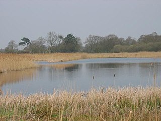
Redgrave and Lopham Fens is a 127 hectare biological Site of Special Scientific Interest between Thelnetham in Suffolk and Diss in Norfolk. It is a national nature reserve, a Ramsar internationally important wetland site, a Nature Conservation Review site, Grade I, and part of the Waveney and Little Ouse Valley Fens Special Area of Conservation. It is managed by the Suffolk Wildlife Trust.

<span class="mw-page-title-main">Fen</span> Type of wetland fed by mineral-rich ground or surface water

A fen is a type of peat-accumulating wetland fed by mineral-rich ground or surface water. It is one of the main types of wetlands along with marshes, swamps, and bogs. Bogs and fens, both peat-forming ecosystems, are also known as mires. The unique water chemistry of fens is a result of the ground or surface water input. Typically, this input results in higher mineral concentrations and a more basic pH than found in bogs. As peat accumulates in a fen, groundwater input can be reduced or cut off, making the fen ombrotrophic rather than minerotrophic. In this way, fens can become more acidic and transition to bogs over time.

<span class="mw-page-title-main">Bog</span> Type of wetland with peat-rich soil

A bog or bogland is a wetland that accumulates peat as a deposit of dead plant materials – often mosses, typically sphagnum moss. It is one of the four main types of wetlands. Other names for bogs include mire, mosses, quagmire, and muskeg; alkaline mires are called fens. A baygall is another type of bog found in the forest of the Gulf Coast states in the United States. They are often covered in heath or heather shrubs rooted in the sphagnum moss and peat. The gradual accumulation of decayed plant material in a bog functions as a carbon sink.

<span class="mw-page-title-main">Askham Bog</span> Protected site and nature reserve in York, England

Askham Bog is small area of peat bog and Site of Special Scientific Interest situated within the Vale of York in North Yorkshire, England. It lies to the south-west of York, north of Copmanthorpe and near Askham Richard and Askham Bryan. It is regarded as one of the most ecologically diverse sites in Northern England.

<span class="mw-page-title-main">Mer Bleue Bog</span>

Mer Bleue Bog is a 33.43 km2 (12.91 sq mi) protected area in Gloucester, Ontario, an eastern suburb of Ottawa in Eastern Ontario, Canada. Its main feature is a sphagnum bog that is situated in an ancient channel of the Ottawa River and is a remarkable boreal-like ecosystem normally not found this far south. Stunted black spruce, tamarack, bog rosemary, blueberry, and cottongrass are some of the unusual species that have adapted to the acidic waters of the bog.

<span class="mw-page-title-main">Reed bed</span> Habitats formed by reed colonies in floodplains and estuaries

A reedbed or reed bed is a natural habitat found in floodplains, waterlogged depressions and estuaries. Reedbeds are part of a succession from young reeds colonising open water or wet ground through a gradation of increasingly dry ground. As reedbeds age, they build up a considerable litter layer that eventually rises above the water level and that ultimately provides opportunities in the form of new areas for larger terrestrial plants such as shrubs and trees to colonise.

Ballynahone Bog is a raised bog, situated in County Londonderry, Northern Ireland, about 3 km south of Maghera, on low-lying ground immediately north of the Moyola River about 14 km from its mouth at Lough Neagh. It is one of the largest lowland raised bogs in Northern Ireland.

This article gives an overview of the mire plant communities in the British National Vegetation Classification system.

<span class="mw-page-title-main">Crymlyn Bog</span> Site of Special Scientific Interest in Wales

Crymlyn Bog is a nature reserve and a designated Site of Special Scientific Interest of international significance, near Swansea, south Wales.

<span class="mw-page-title-main">Lough Derravaragh</span> Lake in County Westmeath, Ireland

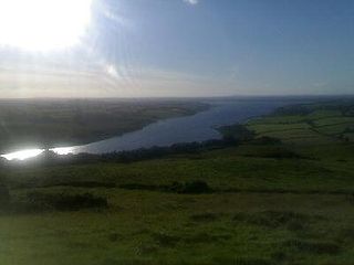
Lough Derravaragh is a lake in County Westmeath, Ireland, north of Mullingar between Castlepollard, Crookedwood and Multyfarnham.

The Portlethen Moss is an acidic bog nature reserve located to the west of the town of Portlethen, Aberdeenshire in Scotland. Like other mosses, this wetland area supports a variety of plant and animal species, even though it has been subject to certain development and agricultural degradation pressures. For example, the Great Crested Newt was found here prior to the expansion of the town of Portlethen. Many acid loving vegetative species occur in Portlethen Moss, and the habitat is monitored by the Scottish Wildlife Trust.

<span class="mw-page-title-main">Ķemeri National Park</span> National park near Jūrmala, Latvia

Ķemeri National Park is a national park west of the city of Jūrmala, Latvia. Established in 1997, Ķemeri is the third largest national park in the country by area, covering an area of 381.65 km2. The territory of the park is mostly occupied by forests and mires, the most significant of them being The Great Ķemeri Bog. There are also several lakes, that are former lagoons of the Littorina Sea. Lake Kaņieris is a Ramsar site. The park also protects the famous natural mineral-springs and muds, used for centuries because of their therapeutic nature. The springs led to development of many resorts, spas, and sanitariums in the 19th century.

<span class="mw-page-title-main">Dersingham Bog</span> English nature reserve

Dersingham Bog is a 159.1-hectare (393-acre) biological and geological Site of Special Scientific Interest in Norfolk, England. It is a Nature Conservation Review site, Grade 2, a National Nature Reserve and a Ramsar site It is part of the Norfolk Coast Area of Outstanding Natural Beauty, and the Roydon Common & Dersingham Bog Special Area of Conservation Part of it is a Geological Conservation Review site.

Minerotrophic refers to environments that receive nutrients primarily through groundwater that flows through mineral-rich soils or rock, or surface water flowing over land. Minerotrophic, “minerogenous”, and “geogenous” are now often used interchangeably, although the latter two terms refer primarily to hydrological systems, while the former refers to nutrient dynamics. The hydrologic process behind minerotrophic wetlands results in water that has acquired dissolved chemicals which raise the nutrient levels and reduce the acidity. This in turn affects vegetation assemblages and diversity in the wetland in question. If dissolved chemicals include chemical bases such as calcium or magnesium ions, the water is referred to as base-rich and is neutral or alkaline. In contrast to minerotrophic environments, ombrotrophic environments get their water mainly from precipitation, and so are very low in nutrients and more acidic. Of the various wetland types, fens and rich fens are often minerotrophic while poor fens and bogs are often ombrotrophic. Marshes and swamps may also be fed through groundwater sources to a degree.

<span class="mw-page-title-main">Mire</span> Wetland terrain without forest cover, dominated by living, peat-forming plants

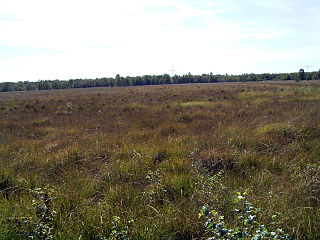
A mire, peatland, or quagmire is a wetland area dominated by living peat-forming plants. Mires arise because of incomplete decomposition of organic matter, usually litter from vegetation, due to water-logging and subsequent anoxia. All types of mires share the common characteristic of being saturated with water, at least seasonally with actively forming peat, while having their own ecosystem. Like coral reefs, mires are unusual landforms that derive mostly from biological rather than physical processes, and can take on characteristic shapes and surface patterning.

<span class="mw-page-title-main">Bewick and Beanley Moors</span>

Bewick and Beanley Moors is the name given to a Site of Special Scientific Interest (SSSI) in north Northumberland, in the north-east of England. The moors are asserted to be of national importance by Natural England for the extent, quality and diversity of upland types including heaths, fens, wet grassland, flushes, mires and blanket bogs, together creating an extensive mosaic habitat supporting an exceptional community of amphibians. The moors are important, too, for their relict juniper woodland and scrub.

<span class="mw-page-title-main">Floating mat</span>

A floating mat is a layer of mosses and other, especially stoloniferous, plants that grows out from the shore across the surface of a lake or pond. This type of habitat is protected and is designated in the European Habitats Directive as "LRT No. 7140 Transition and Floating Mat Bogs".

<span class="mw-page-title-main">Kobuleti Strict Nature Reserve</span> Protected nature area in Georgia (country)

Kobuleti Strict Nature Reserve is a protected area in Kobuleti Municipality, Adjara region of Georgia along the Black Sea coast in the northern part of the resort town Kobuleti. Kobuleti Protected Areas were established in 1998 to preserve unique wetland ecosystems recognized by the Ramsar Convention. Because of these wetland ecosystems, ancient forests, and the high biodiversity found within the reserve, it was inscribed on the UNESCO World Heritage List as part of the Colchic Rainforests and Wetlands in 2021.

References

  1. The Ramsar site is 874 ha.
  2. 1 2 3 4 NBN Species Groups Records at 10km or better [ permanent dead link ]
  3. BBC Cors Caron
  4. BBC Wales News: Trees to unlock bog's history
  5. The Ramsar Convention on Wetlands
  6. "Trawsgoed Estate Walks & Activities". Archived from the original on 5 October 2011. Retrieved 26 December 2008.
  7. "Ystwyth Trail". Archived from the original on 24 April 2009. Retrieved 30 December 2008.
  8. BBC:- £80,000 twitchers' haven to open