Cottonwood, Minnesota

Last updated

Cottonwood, Minnesota
Cottonwood, Minnesota.JPG
Cottonwood from County Highway 9
Lyon County Minnesota Incorporated and Unincorporated areas Cottonwood Highlighted.svg
Location of Cottonwood, Minnesota
Coordinates: 44°36′38″N95°40′19″W / 44.61056°N 95.67194°W / 44.61056; -95.67194
Country United States
State Minnesota
County Lyon
Government
  TypeMayor Council
  MayorCorey Moseng [1] [2]
Area
[3]
  Total1.00 sq mi (2.58 km2)
  Land1.00 sq mi (2.58 km2)
  Water0.00 sq mi (0.00 km2)
Elevation
[4]
1,073 ft (327 m)
Population
 (2020)
  Total1,149
  Density1,153.61/sq mi (445.39/km2)
Time zone UTC-6 (Central (CST))
  Summer (DST) UTC-5 (CDT)
ZIP code
56229
Area code 507
FIPS code 27-13564 [5]
GNIS feature ID2393647 [4]
Website www.cityofcottonwoodmn.gov

Cottonwood is a city in Lyon County, Minnesota, United States. The population was 1,149 at the 2020 census. [6]

Contents

Geography

According to the United States Census Bureau, the city has an area of 1.04 square miles (2.69 km2), all land. [7] It is on the eastern shore of Cottonwood Lake.

Minnesota State Highway 23 serves as a main route in the city.

Demographics

Historical population
CensusPop.Note
1900 549
1910 77040.3%
1920 8135.6%
1930 615−24.4%
1940 69012.2%
1950 7092.8%
1960 7171.1%
1970 79410.7%
1980 92416.4%
1990 9826.3%
2000 1,14816.9%
2010 1,2125.6%
2020 1,149−5.2%
U.S. Decennial Census [8]

2020 census

As of the 2020 census and the 2022 American Community Survey, [6] there were 1,149 people and 492 households in the city. The population density was 1,153.5 inhabitants per square mile (445.4/km2). There were 543 housing units at an average density of 522.1 per square mile (201.6/km2). The racial makeup of the city was 95.8% White, 1.2% African American, 0.7% Native American, 0.3% Asian, 2.1% from other races, and 2.6% from two or more races. Hispanic or Latino of any race were 3.4% of the population.

There were 492 households, of which 28.5% had children under the age of 18 living with them, 48.2% were married couples living together, 28.7% had a female householder with no spouse present, and 13.2% had a male householder with no spouse present. 22.0% of all households had someone living alone who was 65 years of age or older. The average household size was 2.33 and the average family size was 2.98.

The median age in the city was 38.1 years. 24.6% of residents were under the age of 18; 6.9% were between the ages of 18 and 24; 25.8% were from 25 to 44; 28.7% were from 45 to 64; and 14.1% were 65 years of age or older. The gender makeup of the city was 51.0% male and 49.0% female.

2010 census

As of the 2010 census, [9] there were 1,212 people, 504 households, and 331 families living in the city. The population density was 1,104.8 inhabitants per square mile (426.6/km2). There were 545 housing units at an average density of 524.0 per square mile (202.3/km2). The racial makeup of the city was 95.8% White, 0.3% African American, 0.5% Native American, 0.1% Asian, 2.5% from other races, and 0.8% from two or more races. Hispanic or Latino of any race were 4.7% of the population.

There were 504 households, of which 31.0% had children under the age of 18 living with them, 55.2% were married couples living together, 7.3% had a female householder with no husband present, 3.2% had a male householder with no wife present, and 34.3% were non-families. 29.0% of all households were made up of individuals, and 10.7% had someone living alone who was 65 years of age or older. The average household size was 2.39 and the average family size was 2.94.

The median age in the city was 38.8 years. 25.2% of residents were under the age of 18; 7.1% were between the ages of 18 and 24; 25.7% were from 25 to 44; 27% were from 45 to 64; and 15% were 65 years of age or older. The gender makeup of the city was 49.3% male and 50.7% female.

2000 census

As of the 2000 census, [5] there were 1,148 people, 452 households, and 319 families living in the city. The population density was 1,339.0 inhabitants per square mile (517.0/km2). There were 481 housing units at an average density of 561.0 per square mile (216.6/km2). The racial makeup of the city was 96.34% White, 0.09% African American, 0.26% Native American, 0.44% Asian, 2.53% from other races, and 0.35% from two or more races. Hispanic or Latino of any race were 2.26% of the population.

There were 452 households, out of which 38.5% had children under the age of 18 living with them, 60.2% were married couples living together, 7.3% had a female householder with no husband present, and 29.4% were non-families. 26.1% of all households were made up of individuals, and 11.1% had someone living alone who was 65 years of age or older. The average household size was 2.50 and the average family size was 3.03.

In the city, the population was spread out, with 29.2% under the age of 18, 8.1% from 18 to 24, 28.9% from 25 to 44, 18.1% from 45 to 64, and 15.7% who were 65 years of age or older. The median age was 35. For every 100 females, there were 107.2 males. For every 100 females age 18 and over, there were 92.7 males.

The median income for a household in the city was $39,792, and the median income for a family was $49,375. Males had a median income of $31,298 versus $20,795 for females. The city's per capita income was $19,847. About 2.8% of families and 4.5% of the population were below the poverty line, including 4.6% of those under age 18 and 6.9% of those age 65 or over.

Cottonwood bus crash

On February 19, 2008, a minivan ran through a stop sign in Cottonwood and struck a bus carrying students from Lakeview Public Schools, causing the bus to fall onto a pickup truck, killing four students and injuring 17 others. It was the deadliest school-bus related crash to occur in the state since 1997. The driver, Olga Franco del Cid, was later convicted of a total of 24 charges related to the crash and sentenced to 12 years in prison. The crash also fueled the immigration debate in the US, due to Franco del Cid's illegal immigration status. [10] [11]

Related Research Articles

<span class="mw-page-title-main">Watertown, Minnesota</span> City in Minnesota, United States

Watertown is a small city in Carver County, Minnesota, United States, along the South Fork of the Crow River, on the outskirts of the Twin Cities metro area. The population was 4,659 at the 2020 census.

<span class="mw-page-title-main">Lake Shore, Minnesota</span> City in Minnesota, United States

Lake Shore is a city in Cass County, Minnesota, United States. The population was 1,056 at the 2020 census. It is part of the Brainerd Micropolitan Statistical Area.

<span class="mw-page-title-main">Hitterdal, Minnesota</span> City in Minnesota, United States

Hitterdal is a city in Clay County, Minnesota, United States. The population was 199 at the 2020 census.

<span class="mw-page-title-main">Bingham Lake, Minnesota</span> City in Minnesota, United States

Bingham Lake is a city in Cottonwood County, Minnesota, United States. The population was 126 at the 2010 census.

Dale Township is a township in Cottonwood County, Minnesota, United States. The population was 151 at the 2010 census.

<span class="mw-page-title-main">Jeffers, Minnesota</span> City in Minnesota, United States

Jeffers is a city in Amboy Township, Cottonwood County, Minnesota, United States. The population was 369 at the 2010 census.

Midway Township is a township in Cottonwood County, Minnesota, United States. The population was 219 at the 2010 census. The city of Mountain Lake is located in the township.

<span class="mw-page-title-main">Westbrook, Minnesota</span> City in Minnesota, United States

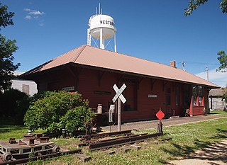
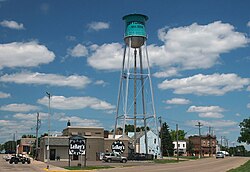
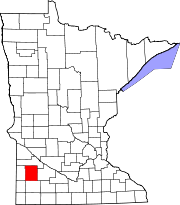
Westbrook is a city in Cottonwood County, Minnesota, United States. The population was 739 at the 2010 census.

<span class="mw-page-title-main">Deerwood, Minnesota</span> City in Minnesota, United States

Deerwood is a city in Crow Wing County, Minnesota, United States. The population was 526 at the 2020 census. It is part of the Brainerd Micropolitan Statistical Area.

<span class="mw-page-title-main">Trommald, Minnesota</span> City in Minnesota, United States

Trommald is a city in Crow Wing County, Minnesota, United States. The population was 99 at the 2020 census. It is part of the Brainerd Micropolitan Statistical Area.

<span class="mw-page-title-main">Kensington, Minnesota</span> City in Minnesota, United States

Kensington is a city in Douglas County, Minnesota, United States. The population was 266 at the 2020 census. The city is notable in Minnesota history for being the place where the Kensington Runestone was first displayed. It is now at a museum in nearby Alexandria, Minnesota.

<span class="mw-page-title-main">Isanti, Minnesota</span> City in the United States

Isanti is a city in Isanti County, Minnesota, United States. The population was 6,804 at the 2020 census. The name Isanti is composed of two Dakota words: isan ("knife") and ati ("camp"), and refers to the Santee Dakota people.

<span class="mw-page-title-main">Bluffton, Minnesota</span> City in Minnesota, United States

Bluffton is a city in Otter Tail County, Minnesota, United States, along the Leaf River. The population was 210 at the 2020 census.

<span class="mw-page-title-main">Deer Creek, Minnesota</span> City in Minnesota, United States

Deer Creek is a city in Otter Tail County, Minnesota, United States. The population was 330 at the 2020 census.

<span class="mw-page-title-main">Henning, Minnesota</span> City in Minnesota, United States

Henning is a city in Otter Tail County, Minnesota, United States. The population was 854 at the 2020 census.

<span class="mw-page-title-main">Sanborn, Minnesota</span> City in Minnesota, United States

Sanborn is a city in Redwood County, Minnesota, United States. The population was 339 at the 2010 census.

<span class="mw-page-title-main">Grant, Minnesota</span> City in Minnesota, United States

Grant is a city in Washington County, Minnesota, and a suburb of St. Paul. The population was 4,096 at the time of the 2010 census.

<span class="mw-page-title-main">Goodview, Minnesota</span> City in Minnesota, United States

Goodview is a city in Winona County, Minnesota, United States. The population was 4,158 at the 2020 census.

<span class="mw-page-title-main">Springfield, Minnesota</span> City in Minnesota, United States

Springfield is a city in Brown County, Minnesota, United States. The population was 2,152 at the 2010 census.

<span class="mw-page-title-main">Minnesota Lake, Minnesota</span> City in Minnesota, United States

Minnesota Lake is a city in Blue Earth and Faribault counties in the State of Minnesota. The population was 661 at the 2020 census. The bulk of the city is in Faribault County; a small part extends into Blue Earth County.

References

  1. "Election 2022 results" . Marshall Independent . Ogden Newspapers. November 10, 2022. Retrieved May 27, 2024.
  2. "Meet Your Elected Officials". City of Cottonwood, MN. n.d. Retrieved May 27, 2024.
  3. "2020 U.S. Gazetteer Files". United States Census Bureau. Retrieved July 24, 2022.
  4. 1 2 U.S. Geological Survey Geographic Names Information System: Cottonwood, Minnesota
  5. 1 2 "U.S. Census website". United States Census Bureau . Retrieved January 31, 2008.
  6. 1 2 "Cottonwood City, Minnesota". United States Census Bureau. Retrieved May 27, 2024.
  7. "US Gazetteer files 2010". United States Census Bureau. Archived from the original on July 2, 2012. Retrieved November 13, 2012.
  8. "Census of Population and Housing". Census.gov. Retrieved June 4, 2015.
  9. "U.S. Census website". United States Census Bureau . Retrieved November 13, 2012.
  10. Dunbar, Elizabeth; Steil, Mark (February 20, 2008). "Four children dead, cause of bus crash still unclear". Minnesota Public Radio News. American Public Media Group . Retrieved January 4, 2020.
  11. Post, Tim (February 26, 2008). "Fatal bus crash spurs immigration debate". Minnesota Public Radio News. American Public Media Group. Retrieved January 4, 2021.