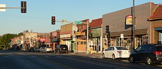
Benson is a historic neighborhood in Omaha, Nebraska. Now a pocket within North Omaha, Benson Place was originally platted in 1887 and was annexed into the City of Omaha in 1917. Actor Nick Nolte lived in the Benson area before moving to the Westside district.

Fort Omaha, originally known as Sherman Barracks and then Omaha Barracks, is an Indian War-era United States Army supply installation. Located at 5730 North 30th Street, with the entrance at North 30th and Fort Streets in modern-day North Omaha, Nebraska, the facility is primarily occupied by Metropolitan Community College. A Navy Operational Support Center and Marine Corps Reserve unit, along with an Army Reserve unit occupy the periphery of the 82.5 acres (33.4 ha) fort. The government deeded all but four parcels of the land to Metropolitan Community College in 1974.
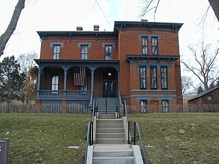
The General George Crook House Museum is located in Fort Omaha. The Fort is located in the Miller Park neighborhood of North Omaha, Nebraska, United States. The house was listed on the National Register of Historic Places in 1969, and is a contributing property to the Fort Omaha Historic District.

The Jewell Building is a city landmark in North Omaha, Nebraska. Built in 1923, it is listed on the National Register of Historic Places. Located at 2221 North 24th Street, the building was home to the Dreamland Ballroom for more than 40 years, and featured performances by many touring jazz and blues legends, including Duke Ellington, Count Basie, Louis Armstrong, Dizzy Gillespie, and Lionel Hampton.

Holy Family Church was built in 1883 at 1715 Izard Street, at the intersections of 18th and Izard Streets in North Omaha, Nebraska within the Roman Catholic Archdiocese of Omaha. It is the oldest existing Catholic Church in Omaha, and is listed on the National Register of Historic Places.

The Drake Court Apartments and the Dartmore Apartments Historic District, built between 1916 and 1921, is located at Jones Street from 20th to 23rd Streets in Midtown Omaha, in the U.S. state of Nebraska. Built in combined Georgian Revival, Colonial Revival and Prairie School styles, the complex was designated a City of Omaha Landmark in 1978; it was listed on the National Register of Historic Places as a historic district in 1980. The historic district originally included 6.5 acres (2.6 ha) with 19 buildings. In 2014, boundary of the historic district was expanded by 0.74 acres (0.30 ha) include three additional buildings, and decreased by 3 acres (1.2 ha) to remove open space and parking that had been re-purposed, for a new total of 4.24 acres (1.72 ha). The district was also renamed to Drake Court Historic District.

Field Club is a neighborhood located in the Midtown region of Omaha, Nebraska. Roughly bounded by Pacific Street, 32nd Avenue, Center St., and 36th Street, the neighborhood was placed on the National Register of Historic Places as a historic district on November 15, 2000. Field Club is the location of dozens of historically significant homes in the Omaha area, including the Gerald R. Ford Birthsite and Gardens.

The Gold Coast Historic District is located in Midtown Omaha, Nebraska. Listed on the National Register of Historic Places in 1997, this historic district covers approximately a 30 block area roughly bounded by 36th, 40th, Jones, and Cuming Streets. The neighborhood housed many of Omaha's cultural and financial leaders between 1900 and 1920, taking over from Omaha's original Gold Coast in prominence.
Morton Meadows is a historic neighborhood located in Midtown Omaha, Nebraska. The neighborhood lies between Center and Leavenworth Streets, from 42nd Street to Saddle Creek, and is sometimes referred to by its central boulevard, Twin Ridge. It is near the Dundee area, as well as the Gold Coast, Field Club and Country Club historic districts.

The Omaha Rail and Commerce Historic District, roughly bounded by Jackson, 15th, and 8th Streets, as well as the Union Pacific main line, is located in downtown Omaha, Nebraska. Today this historic district includes several buildings listed individually on the National Register of Historic Places, including the Union Pacific Depot and the Burlington Station.

The Bemis Park Landmark Heritage District is located in North Omaha, Nebraska. Situated from Cuming Street to Hawthorne Avenue, Glenwood Avenue to 33rd Street, Bemis Park was annexed into Omaha in 1887, and developed from 1889-1922. The district was designated an Omaha Landmark in 1983.

Strehlow Terrace, also called the Terrace Garden Apartment Complex and Ernie Chambers Court, is located at 2024 and 2107 North Sixteenth Street in the Near North Side neighborhood of North Omaha, Nebraska. Designed by Robert Strehlow and reputed local architect Frederick Henninger, Strehlow was added to the National Register of Historic Places in 1986.

Little Bohemia, or Bohemian Town, is a historic neighborhood in Omaha, Nebraska. Starting in the 1880s, Czech immigrants settled in this highly concentrated area, also called "Praha" (Prague) or "Bohemian Town", bounded by South 10th Street on the east, South 16th Street on the west, Pierce Street on the north, and Martha Street on the south, with a commercial area went along South 13th and South 14th Streets, centered on William Street. It was located south of downtown, and directly west of Little Italy. A portion of the neighborhood along South 13th Street was listed on the National Register of Historic Places in 2020.

Jobbers Canyon Historic District was a large industrial and warehouse area comprising 24 buildings located in downtown Omaha, Nebraska, US. It was roughly bound by Farnam Street on the north, South Eighth Street on the east, Jackson Street on the south, and South Tenth Street on the west. In 1989, all 24 buildings in Jobbers Canyon were demolished, representing the largest National Register historic district loss to date.

The Vinton Street Commercial Historic District is located along Vinton Street between Elm Street on the west and South 17th Street on the east in south Omaha, Nebraska. This district is located adjacent to Sheelytown, a residential neighborhood that had historically significant populations of Irish, Poles, and Eastern European immigrants. It grew along with the success of the Union Stockyards and South Omaha. It was added to the National Register of Historic Places in 2006.
Sheelytown was a historic ethnic neighborhood in South Omaha, Nebraska, USA with populations of Irish, Polish and other first generation immigrants. Located north of the Union Stockyards, it was bounded by Edward Creighton Boulevard on the north, Vinton Street on the south, South 24th Street to the east, and 35th Street to the west. Sheelytown was named for the Sheely Brothers Packing Houses that were located in the area. Sheelytown was annexed by Omaha in 1887. The Omaha Quartermaster Depot was built just east of the community across the Union Pacific tracks.

Vinton School was built as a fourteen-room elementary school in 1908 at 2120 Deer Park Boulevard in the Deer Park neighborhood of Omaha, Nebraska, United States. Designed by Omaha architect Frederick W. Clarke, Vinton School is the earliest and most elaborate example of a Tudor Revival-style school in Omaha. Designated an Omaha Landmark in June 1990, the building was listed on the National Register of Historic Places in November 1989.

The present Douglas County Courthouse is located at 1701 Farnam Street in Omaha, Nebraska, United States. Built in 1912, it was added to the National Register of Historic Places in 1979. Notable events at the courthouse include two lynchings and the city's first sit-in during the Civil Rights Movement. Five years after it was opened, the building was almost destroyed by mob violence in the Omaha Race Riot of 1919.

The Beebe and Runyan Furniture Showroom and Warehouse is located at 105 South 9th Street in Downtown Omaha, Nebraska. The building was listed on the National Register of Historic Places on July 23, 1998, and is a contributing property to the Warehouses in Omaha Multiple Property Submission.

The Saddle Creek Underpass is located in the Midtown area of Omaha, Nebraska. Designed to carry Saddle Creek Road under Dodge Street, the underpass was constructed in 1934 by the Works Progress Administration. It was included on the Bridges in Nebraska Multiple Property Submission on June 29, 1992.


