County Borough of Carlisle

Last updated

City of Carlisle
Area
  19012,025 acres (8.19 km2) [1]
  19314,488 acres (18.16 km2) [1]
  19616,092 acres (24.65 km2) [1]
Population
  190145,840 [1]
  193157,304 [1]
  197171,580 [1]
History
  Created1835 (Municipal Corporations Act 1835)
  Abolished1974 (Local Government Act 1972)
  Succeeded by City of Carlisle
Status Municipal borough 1835 – 1914
County borough 1914 – 1974
Government
   HQ Carlisle
   Motto Be Just and Fear Not
Coat of Arms of Carlisle.svg
Coat of arms

Carlisle was, from 1835 to 1974, a local government district in the northwest of England, coterminate with Carlisle. [1] In 1835, following the Municipal Corporations Act 1835, Carlisle was constituted a municipal borough of Cumberland, but was promoted to county borough status in 1914, within its boundaries taking over the functions of Cumberland County Council. The district was abolished on 31 March 1974 by the Local Government Act 1972.

Contents

Carlisle corporation prior to 1835

Carlisle was a borough by prescription, and received its first royal charter from Henry II. It enjoyed the title of "city" by virtue of being the see of an Anglican bishop from 1133. The original charter was lost in 1292 when much of the city was destroyed by fire. In 1352 Edward III granted the city a new charter which confirmed the rights previously enjoyed, and created a close corporation consisting of a mayor and bailiffs. Among the privileges granted to the corporation were the holding of a sixteen-day market beginning on the Feast of the Assumption and the right to the King's fishery in the River Eden. [2]

The charter by which the city was governed prior to the 1835 reforms was that granted by Charles I in 1615. This created a corporation by the name of the Mayor, Aldermen, Bailiffs and Citizens of the City of Carlisle. There were twelve aldermen, one of whom was elected mayor, two coroners and twenty-four capital citizens. [3] The right of election to the body was vested in the free burgesses, who consisted of members of eight fraternities or trade guilds of the city, namely the Merchants, Tanners, Skinners, Butchers, Smiths, Weavers, Tailors and Shoemakers. Burgesses, of which there were estimated to be about a thousand in 1835, did not have to be resident in the city. Elections were held annually at a general meeting on Ascension Day. [4]

The reformed borough

Following the report of a royal commission investigating municipal corporations throughout England and Wales, 178 boroughs were reformed as "municipal boroughs" under the Municipal Corporations Act 1835. The Act introduced a uniform constitution for each borough, which was governed by a town or city council consisting of a mayor, aldermen and councillors. Elections were held annually on 1 November, with one third of councillors retiring each year. There was one alderman for every three councillors, with half of the aldermanic bench being elected by the council itself every three years. The councillors and aldermen elected a mayor from among their number each year. The electorate was widened to include all ten pound householders within the borough. Non-resident freemen no longer had the vote unless they lived within seven miles (11 km) of the city. Later legislation periodically widened the franchise.

The reformed city and municipal borough of Carlisle had an area of 1,800 acres (7.3 km2), as opposed to the old borough which was limited to 80 acres (320,000 m2). The city council consisted of thirty councillors and ten aldermen, with the city divided into ten wards each represented by three councillors and one alderman. [3] [4] The boundaries were enlarged in 1887 and 1912. [5] [6]

Between 1866 and 1906 the borough included the whole or parts of the following civil parishes – Eaglesfield Abbey, Botchergate, Rickergate, Caldewgate, St Cuthberts Within and St Marys Within. In 1906 these were all merged into a single parish called Carlisle whose boundaries were the same as the borough and changed at the same times as the borough's did.

County borough

The Local Government Act 1888 had divided England and Wales into a system of county councils and county boroughs. Under the Act any municipal borough could, on reaching a population of 50,000, apply to become a county borough, independent of the county council. Carlisle made a successful application in 1913, and on 1 April 1914 became a county borough, for its own area taking over the functions of Cumberland County Council. [7] The county borough boundaries were enlarged in 1951. [6]

Coat of arms

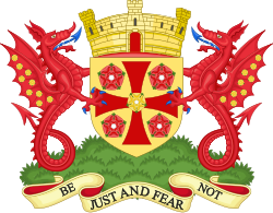
The ancient Carlisle Corporation used a coat of arms from at least 1462. This was a gold shield bearing a red cross pattée between four red roses. A fifth rose, gold in colour was placed in the centre of the cross. [5]

The reformed corporation adopted a completely different coat of arms in 1835, blazoned as Vert on a base barry wavy of six argent and azure, a castle between two roses Or, on a chief gules a lion passant guardant Or. This coat of arms was depicted on a 1610 map of the city engraved by John Speed. The arms had apparently never been used by the corporation prior to 1835, and were probably invented by Speed himself. [5]

By 1915 both coats were in use, and were sometimes displayed side by side. The motto "Be Just And Fear Not" had been adopted. [8] Neither coat, however, was on record at the College of Arms. On 7 July 1924 an official grant by letters patent was made. This featured the ancient arms, topped by a castle in place of a crest, and supported by two red wyverns, with gold roses on their wings. [9] [10]

The arms were blazoned as follows:

Or on a Cross patée between four Roses Gules a Rose of the field barbed and seeded proper. The Shield ensigned by a Mural Crown having three Towers Or and lined Gules the centre Tower pierced by a Gateway Gules. And for Supporters Upon a Mount Vert on either side a Wyvern Gules armed and langued Azure the wings semée of Roses Or barbed Vert. [9]

Abolition

The Local Government Act 1972 reorganised administration throughout England and Wales from 1 April 1974. The area of the county borough was merged with the surrounding Border Rural District to form a new City of Carlisle, one of six districts of the non-metropolitan county of Cumbria. [11]

Related Research Articles

<span class="mw-page-title-main">Cumberland</span> Historic county of England

Cumberland is a historic county in North West England. It covers part of the Lake District as well as the north Pennines and Solway Firth coast. Cumberland had an administrative function from the 12th century until 1974, when it was subsumed into Cumbria, a larger administrative area which also covered Westmorland and parts of Yorkshire and Lancashire. In April 2023, Cumberland was revived as an administrative entity when Cumbria County Council was abolished and replaced by two unitary authorities; one of which is named Cumberland and includes most of the historic county, with the exception of Penrith and the surrounding area.

<span class="mw-page-title-main">Municipal borough</span> Former type of British and Irish local government

Municipal boroughs were a type of local government district which existed in England and Wales between 1835 and 1974, in Northern Ireland from 1840 to 1973 and in the Republic of Ireland from 1840 to 2002. Broadly similar structures existed in Scotland from 1833 to 1975 with the reform of royal burghs and creation of police burghs.

<span class="mw-page-title-main">County Borough of Croydon</span>

The County Borough of Croydon was a local government district in and around the town of Croydon in north east Surrey, England from 1889 to 1965. Since 1965 the district has been part of the London Borough of Croydon within Greater London.

<span class="mw-page-title-main">Municipal Borough of Finchley</span>

Finchley, which is now in north London, was a local government district in Middlesex, England, from 1878 to 1965. Finchley Local Board first met in 1878. It became Finchley District Council in 1895 and the Municipal Borough of Finchley in 1933. In 1965 Middlesex was abolished and Finchley became part of the London Borough of Barnet.

<span class="mw-page-title-main">Municipal Borough of Bexley</span> Abolished 1965

Bexley was a local government district in north west Kent from 1879 to 1965 around the town of Old Bexley.

<span class="mw-page-title-main">Municipal Borough of Acton</span>

Acton was a local government district in Middlesex, England from 1865 to 1965.

<span class="mw-page-title-main">Municipal Borough of Ealing</span>

Ealing was a local government district from 1863 to 1965 around the town of Ealing which formed part of the built up area of London until 1965, where it became part of Greater London.

<span class="mw-page-title-main">Municipal Borough of Enfield</span>

Enfield was a local government district in Middlesex, England from 1850 to 1965.

<span class="mw-page-title-main">Municipal Borough of Southgate</span>

Southgate was a local government district of Middlesex from 1881 to 1965. It was part of the London postal district and Metropolitan Police District.

<span class="mw-page-title-main">Municipal Borough of Uxbridge</span>

Uxbridge was a local government district in north west Middlesex, England, from 1849 to 1965, seated in the town of Uxbridge.

<span class="mw-page-title-main">Municipal Borough of Twickenham</span>

Twickenham was a local government district in Middlesex, England from 1868 to 1965.

<span class="mw-page-title-main">County Borough of Salford</span> Former district of England

Salford was, from 1844 to 1974, a local government district in the county of Lancashire in the northwest of England, covering the city of Salford. It was granted city status in 1926.

<span class="mw-page-title-main">County Borough of Oldham</span>

Oldham was, from 1849 to 1974, a local government district in the northwest of England coterminous with the town of Oldham.

<span class="mw-page-title-main">Coat of arms of Wigan</span>

The coat of arms of Wigan Metropolitan Borough Council was granted by the College of Arms in 1974.

<span class="mw-page-title-main">County Borough of Stockport</span> Former municipal borough in present-day town of Stockport

Stockport County Borough was created by the Municipal Corporations Act 1835 when the existing Borough of Stockport was reformed as a municipal borough. Until 1835 the town was governed by a charter dating from circa 1220 granted by Ranulph de Blondeville, 4th Earl of Chester. The municipal borough consisted of parts of Cheshire, namely the township of Stockport and the neighbouring areas of Edgeley and Portwood and part of Heaton Norris in Lancashire.

<span class="mw-page-title-main">Municipal Borough of Stretford</span>

Stretford was, from 1868 to 1974, a local government district coterminate with the town of Stretford, Lancashire, England.

<span class="mw-page-title-main">County Borough of Bolton</span>

Bolton was, from 1838 to 1974, a local government district in the northwest of England conterminate with the town of Bolton.

<span class="mw-page-title-main">County Borough of Bury</span>

Bury was a local government district centred on Bury in the northwest of England from 1846 to 1974.

<span class="mw-page-title-main">Municipal Borough of Middleton</span>

The Municipal Borough of Middleton was, from 1886 to 1974, a municipal borough in the administrative county of Lancashire, England, coterminous with the town of Middleton.

<span class="mw-page-title-main">Municipal Borough of Heywood</span>

The Municipal Borough of Heywood was, from 1881 to 1974, a local government district in the administrative county of Lancashire, England, with borough status and coterminate with the town of Heywood.

References

  1. 1 2 3 4 5 6 7 "A vision of Carlisle CB/MB". Great Britain Historical GIS . visionofbritain.org.uk. Retrieved 22 June 2009.
  2. Daniel Lysons; Samuel Lysons (1816). "The city of Carlisle". Magna Britannia: volume 4: Cumberland. British History Online. pp. 56–81. Retrieved 23 June 2009.
  3. 1 2 Marr, J E (1910). Cambridge County Geographies: Cumberland. London: Cambridge University Press. p. 139.
  4. 1 2 Samuel Lewis, ed. (1848). "Carburton – Carlisle". A Topographical Dictionary of England. British History Online. pp. 511–520. Retrieved 23 June 2009.
  5. 1 2 3 "Carlisle". Kelly's Directory of Cumberland. Historical Directories. 1910. p. 64. Retrieved 23 June 2009.
  6. 1 2 Youngs, Frederic A Jr. (1991). Guide to the Local Administrative Units of England, Vol.2: Northern England. London: Royal Historical Society. ISBN   0-86193-127-0.
  7. Local Government Board Provisional Orders Confirmation (No.10) Act 1913 (3 & 4 Geo. 5) c. cxxxiv
  8. Fox-Davies, A C (1915). The Book of Public Arms, 2nd edition. London: T C & E C Jack. pp. 154–155.
  9. 1 2 Briggs, Geoffrey (1971). Civic and Corporate Heraldry: A Dictionary of Impersonal Arms of England, Wales and N. Ireland. London: Heraldry Today. pp. 96–97. ISBN   0-900455-21-7.
  10. Scott-Giles, C Wilfrid (1953). Civic Heraldry of England and Wales, 2nd edition. London: J M Dent & Sons. p. 92.
  11. Local government in England and Wales: A Guide to the New System. London: HMSO. 1974. p. 39. ISBN   0-11-750847-0.

Coordinates: 54°53′42″N2°56′00″W / 54.8951°N 2.9334°W / 54.8951; -2.9334