
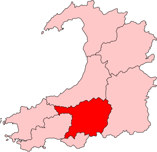
Dyfed is a preserved county in southwestern Wales. It is a mostly rural area with a coastline on the Irish Sea and the Bristol Channel.

Carmarthenshire is a county in the south-west of Wales. The three largest towns are Llanelli, Carmarthen and Ammanford. Carmarthen is the county town and administrative centre. The county is known as the "Garden of Wales" and is also home to the National Botanic Garden of Wales.
Llanelli is a market town and community in Carmarthenshire and the preserved county of Dyfed, Wales. It is located on the Loughor estuary and is the largest town in the county of Carmarthenshire. The town is 11 miles (18 km) north-west of Swansea and 12 miles (19 km) south-east of Carmarthen. The town had a population of 25,168 in 2011, estimated in 2019 at 26,225. The local authority was Llanelli Borough Council when the county of Dyfed existed, but it has been under Carmarthenshire County Council since 1996.

Carmarthen is the county town of Carmarthenshire and a community in Wales, lying on the River Towy 8 miles (13 km) north of its estuary in Carmarthen Bay. The population was 14,185 in 2011, down from 15,854 in 2001, but gauged at 16,285 in 2019. It has a claim to be the oldest town in Wales – Old Carmarthen and New Carmarthen became one borough in 1546. It was the most populous borough in Wales in the 16th–18th centuries, described by William Camden as "chief citie of the country". Growth stagnated by the mid-19th century as new settlements developed in the South Wales Coalfield.

Llandeilo is a town and community in Carmarthenshire, Wales, situated at the crossing of the River Towy by the A483 on a 19th-century stone bridge. Its population was 1,795 at the 2011 Census. It is adjacent to the westernmost point of the Brecon Beacons National Park. The town is served by Llandeilo railway station on the Heart of Wales Line.

Newcastle Emlyn is a town on the River Teifi, straddling the counties of Ceredigion and Carmarthenshire in West Wales. It is also a community entirely within Carmarthenshire, bordered by those of Llangeler and Cenarth, also in Carmarthenshire, and by Llandyfriog in Ceredigion. Adpar is the part of town on the Ceredigion side of the River Teifi. It was formerly called Trefhedyn and was an ancient Welsh borough in its own right. The area including Adpar had a population of 1,883 according to the 2011 census.

Kidwelly is a town and community in Carmarthenshire, southwest Wales, approximately 7 miles (11 km) northwest of the most populous town in the county, Llanelli. In the 2001 census the community of Kidwelly returned a population of 3,289, increasing to 3,523 at the 2011 Census.

Llandovery is a market town and community in Carmarthenshire, Wales. It lies on the River Tywi and at the junction of the A40 and A483 roads, about 25 miles (40 km) north-east of Carmarthen, 27 miles (43 km) north of Swansea and 21 miles (34 km) west of Brecon.

Laugharne is a town on the south coast of Carmarthenshire, Wales, lying on the estuary of the River Tâf.

Carmarthen District Council was one of six local government districts of the county of Dyfed, west Wales, from 1974 to 1996.

Carmarthenshire County Council is the local authority for the county of Carmarthenshire, Wales. It provides a range of services including education, planning, transport, social services and public safety. The council is one of twenty-two unitary authorities that came into existence on 1 April 1996 under the provisions of the Local Government (Wales) Act 1994. It took over local government functions previously provided by the three district councils of Carmarthen, Dinefwr, and Llanelli, as well as the county-level services in the area from Dyfed County Council, all of which councils were abolished at the same time.
Carmarthen East and Dinefwr is a constituency of the Senedd. It elects one Member of the Senedd by the first past the post method of election. Also, however, it is one of eight constituencies in the Mid and West Wales electoral region, which elects four additional members, in addition to eight constituency members, to produce a degree of proportional representation for the region as a whole.

Carmarthen Castle is a ruined castle in Carmarthen, West Wales, UK. First built by Walter, Sheriff of Gloucester in the early 1100s, the castle was captured and destroyed on several occasions before being rebuilt in stone during the 1190s. The castle was captured by Owain Glyndŵr in 1405. Henry VII's father died at Carmarthen Castle in 1456. During the Wars of the Roses the castle fell to William Herbert and, during the Civil War, was captured by Parliamentary forces. It was dismantled by order of Oliver Cromwell in the mid 1600s.

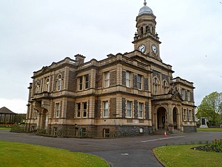
Dyfed County Council was the county council of the non-metropolitan county of Dyfed in south west Wales. It operated between 1974 and 1996. The county council was based at County Hall, Carmarthen.

In the United Kingdom, the term listed building refers to a building or other structure officially designated as being of special architectural, historical, or cultural significance; Grade I structures are those considered to be "buildings of exceptional interest". Listing was begun by a provision in the Town and Country Planning Act 1947. Once listed, strict limitations are imposed on the modifications allowed to a building's structure or fittings. In Wales, the authority for listing under the Planning Act 1990 rests with Cadw.
The administrative county of Carmarthen and the first Carmarthenshire County Council was established in 1889 under the Local Government Act 1888. The first elections were held in January 1889.

Carmarthen Guildhall is a municipal structure in Guildhall Square, Carmarthen, Wales. The guildhall, which was the headquarters of Carmarthen Borough Council, is a Grade I listed building.
Lampeter Town Hall is a municipal structure in the High Street, Lampeter, Wales. The town hall, which was the meeting place of Lampeter Borough Council, is a Grade II listed building.

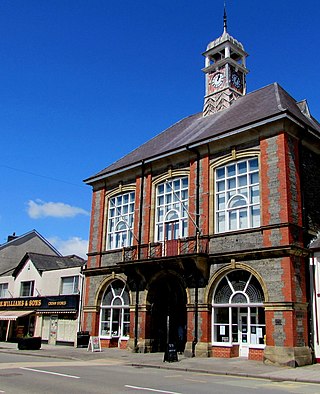
Llandovery Town Hall is a municipal building in Market Street, Llandovery in Carmarthenshire, Wales. The structure, which is used as the local public library, is a Grade II listed building.


