County Hall, Dolgellau

Last updated

County Hall
Native name
Neuadd y Sir Dolgellau
Dolgellau Magistrates' Court - geograph.org.uk - 2153071.jpg
County Hall
LocationSmithfield Street, Dolgellau
Coordinates 52°44′39″N3°53′05″W / 52.7441°N 3.8848°W / 52.7441; -3.8848
Built1825
Architect Edward Haycock
Architectural style(s) Neoclassical style
Listed Building – Grade II*
Official nameCounty Hall
Designated12 February 1952
Reference no.5073
Gwynedd UK location map.svg
Red pog.svg
Shown in Gwynedd

County Hall (Welsh : Neuadd y Sir Dolgellau) is a municipal building in Smithfield Street, Dolgellau, Gwynedd, Wales. The structure, which was the headquarters of Merionethshire County Council, is a Grade II* listed building. [1]

Contents

History

The old courthouse (Y Sospan) Scene outside the Royal Ship 1 - geograph.org.uk - 1531632 (cropped).jpg
The old courthouse (Y Sospan)

The first county building in the town was the old courthouse (Welsh : Y Sospan) in Queen's Square which was built in rubble masonry and completed in 1606. However, by the early 19th century the justices decided it was too small and sought a more substantial structure. [2] [3] [lower-alpha 1]

The building in Smithfield Street was designed by Edward Haycock in the neoclassical style, built in ashlar stone at a cost of £3,000 and was completed in 1825. [1] [6] [7] The design involved a symmetrical main frontage with five bays facing onto Smithfield Street with the end bays shorter than the central section and projected forward; the central section of three bays was fenestrated by three large segmental windows flanked by Tuscan order pilasters, while the end bays contained arched openings with wrought iron gates. The central section and each of the two end bays were surmounted by modillioned pediments. Internally, the principal room was the main courtroom which was in the central section. [1]

The building continued to serve in a judicial capacity as the venue for the courts of assize, with the justices alternating their weekly hearings between Dolgellau and Bala. [8] Following the implementation of the Local Government Act 1888, which established county councils in every county, Merionethshire County Council set up its headquarters in the building, [9] before moving to modern facilities at Cae Penarlag in Dolgellau in 1953. [10] [11]

The building continued to serve as the venue for magistrates' court hearings until the courts service relocated to the Caernarfon Criminal Justice Centre in 2016. [12] The building then remained vacant for two years before being occupied by a dentist's practice in 2018. [13]

See also

Notes

  1. The old courthouse was acquired by Sir Robert Williames Vaughan, 3rd Baronet in 1827 and remained in his ownership until his death in 1859. [2] In the mid-19th century it became a museum and public reading room in what was then described as the old town hall. [4] [5] By the early 20th century it had become a local solicitor's office, [2] and it currently serves as a restaurant and coffee house. [4]

Related Research Articles

<span class="mw-page-title-main">Caernarfon</span> Town in Gwynedd, Wales

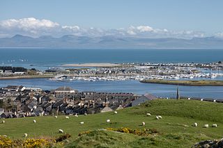
Caernarfon is a royal town, community and port in Gwynedd, Wales. It has a population of 9,852. It lies along the A487 road, on the eastern shore of the Menai Strait, opposite the island of Anglesey. The city of Bangor is 8.6 miles (13.8 km) to the north-east, while Snowdonia (Eryri) fringes Caernarfon to the east and south-east.

<span class="mw-page-title-main">Blaenau Ffestiniog</span> Town in Gwynedd, North Wales

Blaenau Ffestiniog is a town in Gwynedd, Wales. Once a slate mining centre in historic Merionethshire, it now relies much on tourists, drawn for instance to the Ffestiniog Railway and Llechwedd Slate Caverns. It reached a population of 12,000 at the peak development of the slate industry, but fell with the decline in demand for slate. The population of the community, including the nearby village Llan Ffestiniog, was 4,875 in the 2011 census: the fourth most populous in Gwynedd after Bangor, Caernarfon and Llandeiniolen. The population not including Llan is now only about 4,000.
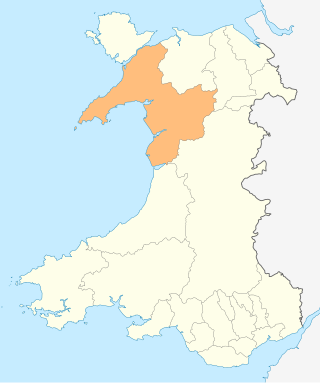
<span class="mw-page-title-main">Caernarfonshire</span> Historic county of Wales

Caernarfonshire, sometimes spelled Caernarvonshire or Carnarvonshire, is one of the thirteen historic counties, a vice-county and a former administrative county of Wales.

<span class="mw-page-title-main">Merionethshire</span> Historic county of Wales

Merionethshire or Merioneth is one of thirteen historic counties of Wales, a vice county and a former administrative county.

<span class="mw-page-title-main">Llandudno</span> Seaside town and community in Wales

Llandudno is a seaside resort, town and community in Conwy County Borough, Wales, located on the Creuddyn peninsula, which protrudes into the Irish Sea. In the 2011 UK census, the community – which includes Gogarth, Penrhyn Bay, Craigside, Glanwydden, Penrhynside, and Bryn Pydew – had a population of 20,701. The town's name means "Church of Saint Tudno".

<span class="mw-page-title-main">Meirionnydd</span> Region of Wales

Meirionnydd is a coastal and mountainous region of Wales. It has been a kingdom, a cantref, a district and, as Merionethshire, a county.

<span class="mw-page-title-main">Pwllheli</span> Town in north-west Wales

Pwllheli is a market town and community of the Llŷn Peninsula, north-western Wales. It lies in the traditional county of Caernarfonshire, but is currently administered as part of the unitary authority of Gwynedd. It had a population of 4,076 in 2011 of whom a large proportion, 81%, are Welsh speaking. Pwllheli is the place where Plaid Cymru was founded. It is the birthplace of the Welsh poet Sir Albert Evans-Jones.

<span class="mw-page-title-main">Barmouth</span> Seaside town in Gwynedd, Wales

Barmouth is a seaside town and community in the county of Gwynedd, north-west Wales; it lies on the estuary of the Afon Mawddach and Cardigan Bay. Located in the historic county of Merionethshire, the Welsh form of the name is derived from aber (estuary) and the river's name, Mawddach. The English form of the name is a corruption of the earlier Welsh form Abermawdd. The community includes the villages of Llanaber, Cutiau and Caerdeon.

<span class="mw-page-title-main">Dolgellau</span> Town in Gwynedd, Wales

Dolgellau is a town and community in Gwynedd, north-west Wales, lying on the River Wnion, a tributary of the River Mawddach. It was the traditional county town of the historic county of Merionethshire until the county of Gwynedd was created in 1974. Dolgellau is the main base for climbers of Cadair Idris and Mynydd Moel which are visible from the town. Dolgellau is the second largest settlement in southern Gwynedd after Tywyn and includes the community of Penmaenpool.

<span class="mw-page-title-main">Aberffraw</span> Village and community in Anglesey, Wales

Aberffraw is a village and community on the south west coast of the Isle of Anglesey, in Wales. The village is 9 miles from the island's capital, Llangefni, and is located is on the west bank of the Afon Ffraw. The community includes Soar and Dothan. Located near the A4080 and the nearest rail station is Bodorgan.

<span class="mw-page-title-main">Llanystumdwy</span> Human settlement in Wales

Llanystumdwy is a predominantly Welsh-speaking village, community and electoral ward on the Llŷn Peninsula in Wales. It lies in the traditional county of Caernarfonshire but is currently administered as part of the unitary authority of Gwynedd. It is not regarded as being part of Llŷn, but as belonging instead to the ancient commote of Eifionydd on the Cardigan Bay coast, where it has its own beach. The community includes the villages of Chwilog, Afon Wen, Llanarmon, and Llangybi, plus the hamlets of Rhoslan and Pencaenewydd.

<span class="mw-page-title-main">Neuadd Idris</span> Municipal Building in Dolgellau, Wales

The Old Market Hall is a municipal building in Eldon Square, Dolgellau, Gwynedd, Wales. The structure, which is now the home to the National Centre for Folk Music, known as Tŷ Siamas, is a Grade II listed building.

<span class="mw-page-title-main">Dyffryn Ardudwy</span> Human settlement in Wales

Dyffryn Ardudwy is a village, community and electoral ward in the Ardudwy area of Gwynedd, Wales. It comprises several small, almost conjoined, villages including Coed Ystumgwern, Llanenddwyn, Llanddwywe, Talybont and Dyffryn Ardudwy. It is situated on the main A496 coast road between Harlech and Barmouth. The ward had a population of 1,540 according to the 2011 census.

Sir Hugh John Ellis-Nanney, 1st Baronet, was a Welsh landowner, magistrate and political candidate.

<span class="mw-page-title-main">Llanegryn</span> Human settlement in Wales

Llanegryn is a village and a community in Gwynedd, north-west Wales. It was formerly part of the historic county of Merionethshire. It is located within Snowdonia National Park south of the Snowdonia (Eryri) mountain range. Travelling by road, it is around 4 miles (6 km) north-east of Tywyn and 17 miles (27 km) south-west of Dolgellau. The nearest railway stations are at Tonfanau and Llwyngwril, both less than 3 miles (5 km) away.

<span class="mw-page-title-main">Grade I listed buildings in Gwynedd</span>

In the United Kingdom, the term listed building refers to a building or other structure officially designated as being of special architectural, historical, or cultural significance; Grade I structures are those considered to be "buildings of exceptional interest". Listing was begun by a provision in the Town and Country Planning Act 1947. Once listed, strict limitations are imposed on the modifications allowed to a building's structure or fittings. In Wales, the authority for listing under the Planning Act 1990 rests with Cadw.

<span class="mw-page-title-main">Nannau, Wales</span> Grade II* listed building in Gwynedd, Wales

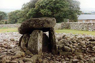
Nannau is a Georgian mansion and estate near the village of Llanfachreth, Gwynedd, North Wales, UK. The mansion was initially inhabited by the Welsh Nanney (Nannau) family, who were direct descendants of the Kings of Powys. For over 900 years, the Nannau estate was in possession of the same family.

<span class="mw-page-title-main">County Hall, Caernarfon</span> County building in Caernarfon, Wales

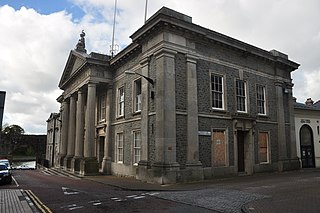
County Hall is a former municipal facility at Castle Ditch in Caernarfon, Wales. The County Hall, which was the headquarters of Caernarfonshire County Council from 1889 to 1974, is a Grade I listed building.

<span class="mw-page-title-main">Shire Hall, Haverfordwest</span> County building in Haverfordwest, Wales

The Shire Hall is a municipal structure in the High Street, Haverfordwest, Pembrokeshire, Wales. The shire hall, which was the meeting place of the old Pembrokeshire County Council, is a Grade II* listed building.

<span class="mw-page-title-main">Bala Town Hall</span> Municipal Building in Bala, Wales

Bala Town Hall, known in the late 19th century as the County Hall, is a municipal building in Bala, Gwynedd, Wales. The structure, which is now used as a restaurant, is a Grade II listed building.

References

  1. 1 2 3 Cadw. "County Hall (5073)". National Historic Assets of Wales . Retrieved 29 May 2022.
  2. 1 2 3 "Old Shire Hall, Dolgellau". Archives Hub. Retrieved 29 May 2022.
  3. Cadw. "Old Courthouse (Y Sospan Fach) (5061)". National Historic Assets of Wales . Retrieved 29 May 2022.
  4. 1 2 "About Y Sospan" . Retrieved 29 May 2022.
  5. "Dolgellau (33154)". Coflein. RCAHMW . Retrieved 29 May 2022.
  6. Colvin, Howard Montagu (1995). A Biographical Dictionary of British Architects 1600-1840: Third Edition. Yale University Press. p. 479. ISBN   978-0300125085.
  7. "Dolgellau Town Trail". Garthyfog Farm. Retrieved 29 May 2022.
  8. Hemingway, Joseph (1844). Panorama of the Beauties, Curiosities and Antiquities of North Wales. R. Groombridge. p. 155.
  9. "Historic Landscape Characterisation: Dolgellau". Gwynedd Archaeological Trust. Retrieved 29 May 2022.
  10. "No. 43451". The London Gazette . 2 October 1964. p. 8301.
  11. "Chronology". Dolgellau. 6 October 1964. Retrieved 29 May 2022.
  12. "Dolgellau court to close". Cambrian News. 11 February 2016. Retrieved 29 May 2022.
  13. "Toothache town where patients faced 100 mile journey for NHS dentist finally has a cure". Daily Post. 17 November 2018. Retrieved 29 May 2022.