
The Mechanic Street Historic District encompasses a historic 19th-century mill and mill village in a 14-block area of the Pawcatuck section of Stonington, Connecticut. Extending along the Pawcatuck River and south of West Broad Street, the area includes a large brick mill complex on the banks of the river, and a neighborhood of well-preserved worker housing on the road grid to its west. The district was listed on the National Register of Historic Places in 1988.

The Old Jeffersonville Historic District is located in Jeffersonville, Indiana, United States. It marks the original boundaries of Jeffersonville, and is the heart of modern-day downtown Jeffersonville. It was placed on the National Register of Historic Places in 1983. The area is roughly bounded by Court Avenue at the North, Graham Street on the east, the Ohio River at the south, and Interstate 65 at the west. In total, the district has 203 acres (0.8 km2), 500 buildings, 6 structures, and 11 objects. Several banks are located in the historic buildings in the district. The now defunct Steamboat Days Festival, held on the second weekend in September, used to be held on Spring Street and the waterfront. Jeffersonville's largest fire wiped out a block in the historic district on January 11, 2004 which destroyed the original Horner's Novelty store.

The Warren Waterfront Historic District encompasses the center of Warren, Rhode Island. It is bounded on the west by the Warren River, on the north roughly by Belcher Cove, on the east roughly by Federal and Main Streets, and on the south by Campbell Street. This area is a densely built residential, commercial, and civic area that has been the center of Warren since the mid-18th century. The town prospered in the 19th century, first as a whaling and shipbuilding center and later with industrial development. The district includes the town's major civic buildings, as well as a wide variety of housing in 19th century revival and Victorian styles. It was listed on the National Register of Historic Places in 1974, and enlarged in 2003.

The Old Shipbuilder's Historic District is a 287-acre (116 ha) historic district in Duxbury, Massachusetts. The district includes both sides of Washington Street extending from South Duxbury to Powder Point Avenue, including several side streets off of Washington and a small portion of St. George Street and Powder Point Avenue.

The Main Street Historic District encompasses the historic late 19th and early 20th-century commercial heart of Webster, Massachusetts. It consists of fourteen buildings on Main Street in downtown Webster, between High and Church Streets. This area contains the highest concentration of period commercial buildings in the town. The district was listed on the National Register of Historic Places in 1982.

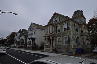
The Lower Highlands Historic District encompasses one of the oldest residential areas of Fall River, Massachusetts. The district is roughly bounded by Cherry, Main, Winter, and Bank Streets, and is located just east of the Downtown Fall River Historic District and directly south of the Highlands Historic District. This area was settled by 1810, has architecture tracing the city's growth as a major industrial center. The historic district was added to the National Register of Historic Places in 1984.
The North Bedford Historic District is a historic district roughly bounded by Summer, Parker, Pleasant and Kempton Streets in New Bedford, Massachusetts. It encompasses a predominantly residential neighborhood north of downtown New Bedford which was developed primarily in the mid 19th-century. It features a variety of worker housing of the period, as well as a number of higher quality houses built by businessmen. The district was added to the National Register of Historic Places in 1979.

The Dighton Wharves Historic District is a historic district at 2298-2328 Pleasant Street in Dighton, Massachusetts. It encompasses an area that was in the 18th and 19th centuries a port facility on the Taunton River for the town, including three 18th-century wharves and four houses of early to mid 18th-century construction. The district was added to the National Register of Historic Places in 1997.

Hortonville is a village in the town of Swansea, Bristol County, Massachusetts, United States. The part of the village on Locust Street from Oak Street to Hortonville Rd. makes up the Hortonville Historic District, which was listed on the National Register of Historic Places in 1990.

Mill River Historic District is a historic district encompassing the traditional center of government and a former industrial mill village along the Konkapot River in the village of Mill River in New Marlborough, Massachusetts. The district is roughly bounded by Main Street and River Church, Southfield, Clayton, School, and Hayes Hill Roads. It encompasses about 425 acres (172 ha), and contains mostly 19th century residential and civic buildings, as well as remnants of 19th century industrial activity.
Church Street Historic District is a historic district roughly on Church Street between Park Ave. and Highland St. in Ware, Massachusetts. This mainly residential area includes some of Ware's finest late 19th century houses and a well-preserved collection of Greek Revival houses. The area was developed primarily in response to the growth of industry to the south. The district was listed on the National Register of Historic Places in 1983.
The Prospect—Gaylord Historic District is a historic district encompassing a residential area built up mostly in the late 19th century just outside the central business district of Amherst, Massachusetts. Contributing properties include most of the houses on Prospect Street, which parallels Pleasant Street, as well as properties on Gaylord and Amity Streets running west from Prospect. These houses are generally in late Victorian styles such as Queen Anne, although some, for example a workman's house at 24 Gaylord Street, are in a more vernacular style. A central element of the district is the Hope Community Church, a historically African American church built in 1912 for a congregation whose history dates to 1869. Funds for its construction were raised in part through the efforts of W.E.B. Du Bois. The district was listed on the National Register of Historic Places in 1993.

The Springfield Street Historic District is a predominantly residential historic district south of the downtown area of Chicopee, Massachusetts. It encompasses a significant number of Queen Anne style houses built in the second half of the 19th century by wealthy residents of Chicopee, as well as housing for skilled workers at the nearby textile mills. It is centered where Springfield Street and Fairview Avenue meet. The district was listed on the National Register of Historic Places in 1991.

The East End Historic District encompasses the historic eastern portion of central Ipswich, Massachusetts. The now predominantly residential district is bounded on the north and west by East Street, running from its junction with North Main and High Streets to Jeffrey's Neck Road. The eastern boundary includes the Ipswich River and Turkey Shore Road from its junction with Labor-in-Vain Road to Green Street, and the southern boundary runs along Green Street to North Main. The district was listed on the National Register of Historic Places in 1980.

The Waterville Village Historic District encompasses most of the history 19th and early 20th-century village center of Waterville, Vermont. The village grew from beginnings late in the 18th century to serve as a modest civic, commercial, and residential hub for the rural community. It was added to the National Register of Historic Places in 2007.

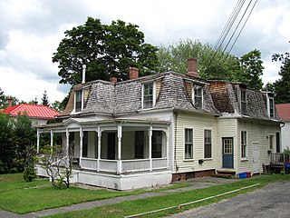
The Jewell Town District of South Hampton, New Hampshire, encompasses a colonial-era industrial village with a history dating to 1687. It is centered at the junction of West Whitehall and Jewell Streets, which is just south of a bend in the Powwow River, the source of the power for the mills that were built here. The area was settled in 1687 by Thomas Jewell, and by the early 19th century included a variety of mills as well as a bog iron works. The district now includes only remnants of its industrial past, and features a collection of 18th and early-19th century residential architecture. The district was listed on the National Register of Historic Places in 1983.
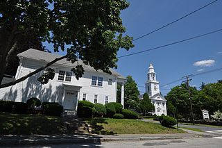
The Federal Street Historic District of Brunswick, Maine encompasses a part of the town whose development was influenced by its 18th-century success as a shipping center, and by the presence of Bowdoin College, whose historic central campus is part of the district. In addition to the campus, the district includes a series of relatively high-style Federal and later-period houses along Federal Street and Maine Street, which join the campus to downtown Brunswick. The district was listed on the National Register of Historic Places in 1976.

The Bath Historic District encompasses the historic 19th-century business district of Bath, Maine, along with an adjacent period neighborhood. The city has a long history as one of the nation's preeminent shipbuilding centers. The district was listed on the National Register of Historic Places in 1973.

The Bluefish River is a stream in Duxbury, Massachusetts ending in a tidal river estuary that was the center of an active shipbuilding industry during the early 19th century. Its source is a set of small ponds located near the intersection of Partridge Road and Washington Street, about one-third of a mile from Hall's Corner in Duxbury. The river is fed by Hounds Ditch Brook which empties into the Bluefish at the tidal estuary. The river contains Duxbury’s second anadromous fish run, with a privately-owned fish ladder south of Harrison Street. A large portion of the northern shore of the Bluefish River estuary is occupied by the Capt. David Cushman Preserve operated by the Wildlands Trust which contains walking trails with views of the estuary. Near its mouth, the river passes under the stone Bluefish River Bridge, a local landmark and part of the Old Shipbuilders Historic District. The river discharges into Duxbury Bay between Long Point and Bumpus Park.

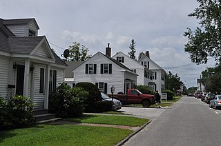
The Somerset Village Historic District is a historic district encompassing the historic town center of Somerset, Massachusetts. Settled in the 17th century, the village developed around a shipyard and pottery works, and became the town center when it was incorporated out of Swansea in 1790. Architecturally it is reflective mainly of its 19th-century growth, with stylistically diverse buildings. The district was added to the National Register of Historic Places in 2020.


