
The Cotswolds is a region in central-southwest England, along a range of rolling hills that rise from the meadows of the upper Thames to an escarpment above the Severn Valley and Evesham Vale.

Cirencester is a market town in Gloucestershire, England, 80 miles (130 km) west of London. Cirencester lies on the River Churn, a tributary of the River Thames, and is the largest town in the Cotswolds. It is the home of the Royal Agricultural University, the oldest agricultural college in the English-speaking world, founded in 1840.

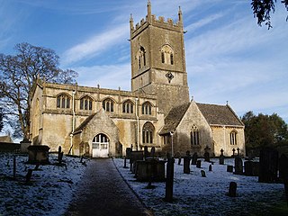
Bishop's Cleeve is a large village in the Borough of Tewkesbury, Gloucestershire, north of Cheltenham. The village lies at the foot of Cleeve Hill, the highest point in the Cotswolds, and borders Woodmancote on the east side of the Gloucestershire Warwickshire railway line that splits the two parishes. Bishop's Cleeve had a population of 10,612 in 2011, and was estimated to be over 17,000 in 2018. The village saw rapid growth during the 20th century as a result of the construction of Smiths Aerospace factory near the village after the Second World War. Currently, population and residential growth is a contentious subject due to the vast expansion of the housing estates without increased amenities. At the moment, a bid for 500 more houses has been refused but is currently under appeal.

Churchdown is a large village in Gloucestershire, England, situated between Gloucester and Cheltenham in the south of the Tewkesbury Borough.

Northleach is a market town in Northleach with Eastington civil parish in Gloucestershire, England. The town is in the valley of the River Leach in the Cotswolds, about 10 miles (16 km) northeast of Cirencester and 11 miles (18 km) east-southeast of Cheltenham. The 2011 Census recorded the parish's population as 1,854.

Charlton Kings is a contiguous village adjoining Cheltenham in Gloucestershire, England. The area constitutes a civil parish of 10,396 residents (2011).

Aldsworth is a village and civil parish in the Cotswold district of Gloucestershire, about ten miles north-east of Cirencester. In 2010 its population was 236. Aldsworth is a large parish, slightly north of the River Leach, located in the South West of the United Kingdom. The Parish was once a possession of the Abbey of Gloucester.

South Cerney is a village and civil parish in the Cotswold district of Gloucestershire, 3 miles south of Cirencester and close to the border with Wiltshire. It had a population of 3,074 according to the 2001 census, increasing to 3,464 at the 2011 census. It was founded in 999 by Saxon settlers, with a charter by King Aethelred II. In 2001 South Cerney was winner of the Bledisloe Cup for the best-kept village in Gloucestershire, having previously won the award in 1955.

Barnsley is a village and civil parish in the Cotswold district of Gloucestershire, England, 3.7 miles (6.0 km) northeast of Cirencester. It is 125 kilometres (78 mi) (geodesically) west of London.

Upper Rissington is a village and civil parish in the Cotswold district of Gloucestershire, England. It is located about two-and-a-half miles east of Bourton-on-the-Water and is one of the highest villages in the Cotswolds at an elevation of 275 m. The village is on the former site of the Central Flying School and the airfield is still the active RAF site of RAF Little Rissington.

Somerford Keynes is a village and civil parish in Gloucestershire, England, close to the River Thames and about 5 miles from its source. It lies on the boundary with Wiltshire, midway between Cirencester, Swindon and Malmesbury. The parish population at the 2011 census was 479. A 2019 estimate put it at 558.

Daglingworth is a Gloucestershire village in the valley of the River Dunt, near the A417 road connecting Gloucester and Cirencester. As with many smaller villages in the Cotswolds, most of the buildings are now private houses. Other properties are the church, the village hall, a stable & horse riding centre and Bridge Farm. The Church of the Holy Rood in the village is an Anglo-Saxon church with well-preserved stone carvings, including an Anglo-Saxon crucifixion tablet dating to 1015. There is also a canonical sundial on the south wall.
Withington is a Cotswold village and civil parish in Gloucestershire, England, about 6+1⁄2 miles (10 km) southeast of Cheltenham and 8 miles (13 km) north of Cirencester. The River Coln runs through the village. The parish includes the hamlets of Hilcot, Foxcote and Cassey Compton. The parish population taken at the 2011 census was 532.

Birdlip is a village in Cotswold District of Gloucestershire in England, in the Cotswolds Area of Outstanding Natural Beauty, at an altitude of 287 m (940 ft), and about 6 miles (9.7 km) south of Cheltenham and 8 miles (13 km) south east of Gloucester.
Siddington is a village and civil parish in Gloucestershire, England. It is located immediately south of Cirencester. At the 2011 United Kingdom Census, the parish had a population of 1,249.

Edgeworth is a small village and civil parish in the English county of Gloucestershire. It is located east of Stroud, west of Cirencester and south of Cheltenham.

Elkstone is a village and civil parish in the English county of Gloucestershire. In the 2001 United Kingdom census, the parish had a population of 203, increasing to 248 at the 2011 census

Syde, often in the past spelt Side, is a small village and civil parish in Gloucestershire, England. It lies in the Cotswolds, near the source of the River Frome, some six miles north west of Cirencester and seven miles east of Painswick.

Colesbourne is a village and civil parish in the Cotswold district of Gloucestershire, England. The village and parish lies within the Cotswolds, a designated Area of Outstanding Natural Beauty.

Stratton is a village, ward and former civil parish about 22 miles from Gloucester, now in the parish of Cirencester, in the Cotswold district, in the county of Gloucestershire, England. In 2018 the built up area and ward had an estimated population of 2584. In 1931 the parish had a population of 963. Stratton was on the A417, construction of the Cirencester and Stratton bypass was due to be started in 1994 and was complete in December 1997.

