Craigmont, Idaho

Last updated

Craigmont, Idaho
Lewis County Idaho Incorporated and Unincorporated areas Craigmont Highlighted 1619270.svg
Location of Craigmont in Lewis County, Idaho.
Coordinates: 46°14′32″N116°28′14″W / 46.24222°N 116.47056°W / 46.24222; -116.47056
Country United States
State Idaho
County Lewis
Area
[1]
  Total0.78 sq mi (2.02 km2)
  Land0.78 sq mi (2.01 km2)
  Water0.00 sq mi (0.00 km2)
Elevation
3,740 ft (1,140 m)
Population
 (2010) [2]
  Total501
  Estimate 
(2019) [3]
489
  Density629.34/sq mi (242.86/km2)
Time zone UTC-8 (Pacific (PST))
  Summer (DST) UTC-7 (PDT)
ZIP code
83523
Area code 208
FIPS code 16-19270
GNIS feature ID0399839

Craigmont is a city in the northwest United States in Lewis County, Idaho. Located on the Camas Prairie in north central Idaho, it is within the Nez Perce Indian Reservation. [4] The population was 501 at the 2010 census, down from 556 in 2000.

Contents

History

The city is named for Colonel William Craig (1809–69), [5] a mountain man who had a Nez Perce wife. He settled at Lapwai near his father-in-law Hin-mah-tute-ke-kaikt or James in 1840 when he gave up being a fur trapper due to the collapse of the market for beaver. [6] [7] [8] [9]

The Nez Perce Reservation was opened to white settlement 128 years ago in 1895, [10] [11] [12] [13] and a town named "Chicago," a mile west of the current Craigmont, was founded in 1898. In response to not getting their mail from the post office, it was renamed "Ilo" four years later, after Ilo Leggett, daughter of town founder and merchant W.O. Leggett. A fire burnt the town in 1904 and shortly thereafter the Camas Prairie Railroad bypassed the town and started a settlement, platted by Lewiston financier John P. Vollmer, on the northeast side of the railroad tracks, and he named it "Vollmer." Ilo responded and moved its community to the southwest side of the tracks, adjacent to Vollmer. After a decade-long feud and the consolidation of the school districts, the communities merged in 1920 to become Craigmont. [5] [14] [15]

Geography

Craigmont is located at 46°14′32″N116°28′14″W / 46.24222°N 116.47056°W / 46.24222; -116.47056 (46.2422, -116.4705), [16] on the Camas Prairie. Located within the Nez Perce Indian Reservation, [4] its elevation is 3,740 feet (1,140 m) above sea level. [17]

According to the United States Census Bureau, the city has a total area of 0.76 square miles (1.97 km2), all of it land. [18]

Climate

The climate in this area has mild differences between highs and lows, and there is adequate rainfall year-round. According to the Köppen Climate Classification system, Craigmont has a humid continental climate, abbreviated "Dfb" on climate maps. [19]

Climate data for Craigmont (1950-1996)
MonthJanFebMarAprMayJunJulAugSepOctNovDecYear
Record high °F (°C)55
(13)
66
(19)
69
(21)
83
(28)
89
(32)
94
(34)
97
(36)
96
(36)
95
(35)
84
(29)
69
(21)
57
(14)
97
(36)
Average high °F (°C)35
(2)
39
(4)
47.1
(8.4)
54
(12)
61.6
(16.4)
69.1
(20.6)
77.3
(25.2)
78.2
(25.7)
69.3
(20.7)
57
(14)
40.5
(4.7)
33.5
(0.8)
55.1
(12.8)
Average low °F (°C)20.9
(−6.2)
21.4
(−5.9)
27.7
(−2.4)
32
(0)
37.6
(3.1)
43
(6)
47
(8)
46.3
(7.9)
39.7
(4.3)
32.9
(0.5)
25.4
(−3.7)
18.9
(−7.3)
32.7
(0.4)
Record low °F (°C)−19
(−28)
−27
(−33)
−2
(−19)
17
(−8)
23
(−5)
29
(−2)
31
(−1)
26
(−3)
19
(−7)
10
(−12)
−13
(−25)
−28
(−33)
−28
(−33)
Average precipitation inches (mm)1.61
(41)
1.48
(38)
2.18
(55)
2.34
(59)
2.8
(71)
2.07
(53)
1.55
(39)
1
(25)
1.26
(32)
1.53
(39)
2.29
(58)
1.46
(37)
21.58
(548)
Average snowfall inches (cm)14.1
(36)
10
(25)
8.7
(22)
3.6
(9.1)
0.9
(2.3)
0
(0)
0
(0)
0
(0)
0.1
(0.25)
1.2
(3.0)
10.6
(27)
11.9
(30)
61
(150)
Average precipitation days131215141412867101714142
Source: WRCC [20]

Transportation

Railroad

Four miles (7 km) south of the city is Lawyers Creek Canyon, with large railroad trestles [21] of the Camas Prairie Railroad, whose second subdivision arrived on the Camas Prairie in 1908 and extended to Grangeville the following year. The largest is the massive century-old steel trestle, 1,488 feet (454 m) in length and its track 287 feet (87 m) above the creek. [22] After several ownership changes since 1998, the line from Spalding is now operated by BG&CM Railroad and terminates in Cottonwood. Passenger service on the Camas Prairie ended in 1955. [23] Lawyers Canyon is named after Chief Lawyer (1801–76) of the Nez Perce, nicknamed for his skill in dealing with the encroaching whites; he is buried in Kamiah. [24]

Highways

Northbound U.S. Route 95 was formerly routed westward through Craigmont as Main Street, then resumed westward toward Winchester. The highway was re-routed in 1991 and now bypasses Craigmont on its south side. Southbound, the new route between Craigmont and Ferdinand stays out of the canyon, crossing it on a 919-foot (280 m) bridge (photo) which opened in October 1991 [25] and passes over the site of the previous 82-foot (25 m) bridge, built in 1948. [26] [27] After the bridge, the southbound highway passes to the east of Ferdinand, a new routing completed in 1993. [28] [29]

Eastbound from Craigmont, State Highway 62 connects to Nezperce, the county seat.

Demographics

Historical population
CensusPop.Note
1930 496
1940 5286.5%
1950 59412.5%
1960 70318.4%
1970 554−21.2%
1980 61711.4%
1990 542−12.2%
2000 5562.6%
2010 501−9.9%
2019 (est.)489 [3] −2.4%
U.S. Decennial Census [30]

2010 census

As of the census [2] of 2010, there were 501 people, 230 households, and 149 families residing in the city. The population density was 659.2 inhabitants per square mile (254.5/km2). There were 261 housing units at an average density of 343.4 per square mile (132.6/km2). The racial makeup of the city was 95.2% White, 0.6% Native American, 1.0% Asian, 0.2% Pacific Islander, 1.6% from other races, and 1.4% from two or more races. Hispanic or Latino of any race were 2.0% of the population.

There were 230 households, of which 21.3% had children under the age of 18 living with them, 54.3% were married couples living together, 7.4% had a female householder with no husband present, 3.0% had a male householder with no wife present, and 35.2% were non-families. 31.7% of all households were made up of individuals, and 17.4% had someone living alone who was 65 years of age or older. The average household size was 2.18 and the average family size was 2.68.

The median age in the city was 49.4 years. 18.2% of residents were under the age of 18; 6.2% were between the ages of 18 and 24; 18.2% were from 25 to 44; 37.8% were from 45 to 64; and 19.8% were 65 years of age or older. The gender makeup of the city was 49.7% male and 50.3% female.

2000 census

As of the census [31] of 2000, there were 556 people, 225 households, and 157 families residing in the city. The population density was 743.8 inhabitants per square mile (287.2/km2). There were 248 housing units at an average density of 331.8 per square mile (128.1/km2). The racial makeup of the city was 97.12% White, 1.44% Native American, 0.36% Asian, 0.90% from other races, and 0.18% from two or more races. Hispanic or Latino of any race were 0.54% of the population.

There were 225 households, out of which 31.6% had children under the age of 18 living with them, 60.9% were married couples living together, 6.2% had a female householder with no husband present, and 30.2% were non-families. 23.6% of all households were made up of individuals, and 10.7% had someone living alone who was 65 years of age or older. The average household size was 2.47 and the average family size was 2.94.

In the city, the population was spread out, with 26.6% under the age of 18, 5.8% from 18 to 24, 28.1% from 25 to 44, 24.3% from 45 to 64, and 15.3% who were 65 years of age or older. The median age was 39 years. For every 100 females, there were 109.0 males. For every 100 females age 18 and over, there were 105.0 males.

The median income for a household in the city was $31,806, and the median income for a family was $36,719. Males had a median income of $36,250 versus $21,250 for females. The per capita income for the city was $16,548. About 12.9% of families and 13.0% of the population were below the poverty line, including 11.9% of those under age 18 and 11.5% of those age 65 or over.

Education

Craigmont is the home of Highland High School, with an average of 20 to 25 students per graduating class. The Huskies compete in athletics at the IHSAA Class 1A level. The Highland Joint School District #305 was established in 1962 and includes Craigmont, Winchester, Melrose, and Reubens. [32] [33] The current campus of the school was constructed in 1952. [15]

Related Research Articles

<span class="mw-page-title-main">Nez Perce</span> Indigenous peoples of North America

The Nez Perce are an Indigenous people of the Plateau who still live on a fraction of the lands on the southeastern Columbia River Plateau in the Pacific Northwest. This region has been occupied for at least 11,500 years.

<span class="mw-page-title-main">Lewiston, Idaho</span> City in Idaho, United States

Lewiston is a city and the county seat of Nez Perce County, Idaho, United States, in the state's north central region. It is the third-largest city in the northern Idaho region, behind Post Falls 38,485, and Coeur d'Alene 54,628, and twelfth-largest in the state. Lewiston is the principal city of the Lewiston, ID-WA Metropolitan Statistical Area, which includes all of Nez Perce County and Asotin County, Washington. As of the 2020 census, the population of Lewiston was 34,203 up from 31,894 in 2010.

<span class="mw-page-title-main">Lewis County, Idaho</span> County in Idaho, United States

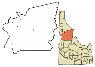
Lewis County is a county located in the north central region of the U.S. state of Idaho. As of the 2020 census, the population was 3,533, making it the fourth-least populous county in Idaho. The county seat is Nezperce, and Kamiah is the largest city. Partitioned from Nez Perce County and established in 1911, it was named after the explorer Meriwether Lewis. Most of the county is within the Nez Perce Indian Reservation, though Native Americans comprise less than 6% of the county population. Similar to the opening of lands in Oklahoma, the U.S. government opened the reservation for white settlement in November 1895. The proclamation had been signed less than two weeks earlier by President Cleveland.

<span class="mw-page-title-main">Latah County, Idaho</span> County in Idaho, United States

Latah County is a county located in the north central region of the U.S. state of Idaho. As of the 2020 census, the population was 39,517. The county seat and largest city is Moscow, the home of the University of Idaho, the state's flagship university.

<span class="mw-page-title-main">Idaho County, Idaho</span> County in Idaho, United States

Idaho County is a county in the U.S. state of Idaho, and the largest by area in the state. As of the 2020 census, the population was 16,541. The county seat is Grangeville. Previous county seats of the area were Florence (1864–68), Washington (1868–75), and Mount Idaho (1875–1902).

<span class="mw-page-title-main">Orofino, Idaho</span> City in Idaho, United States

Orofino is a city in and the county seat of Clearwater County, Idaho, United States, along Orofino Creek and the north bank of the Clearwater River. It is the major city within the Nez Perce Indian Reservation. The population was 3,142 at the time of the 2010 census.

<span class="mw-page-title-main">Pierce, Idaho</span> City in Idaho, United States

Pierce is a city in the northwest United States, located in Clearwater County, Idaho. The population was 508 at the 2010 census, down from 617 in 2000.

<span class="mw-page-title-main">Cottonwood, Idaho</span> City in the United States

Cottonwood is a city in Idaho County, Idaho. On the Camas Prairie in north central Idaho, the population was 900 at the 2010 census, down from 944 in 2000. It is just west of U.S. Route 95, between Grangeville and Lewiston.

<span class="mw-page-title-main">Ferdinand, Idaho</span> City in Idaho, United States

Ferdinand is a city in Idaho County, Idaho, United States. The population was 159 at the 2010 census, up from 145 in 2000. At the southern end of the Nez Perce Indian Reservation, it was founded by F.M. Bieker shortly after the reservation was opened for settlement in 1895. It was named after Ferdinand, Indiana, where his mother's family had lived.

<span class="mw-page-title-main">Grangeville, Idaho</span> City in Idaho, United States

Grangeville is the largest city in and the county seat of Idaho County, Idaho, United States, in the north central part of the state. Its population was 3,141 at the 2010 census, down from 3,228 in 2000.

<span class="mw-page-title-main">Kamiah, Idaho</span> City in Idaho, United States

Kamiah is a city in Lewis and Idaho counties in the U.S. state of Idaho. The largest city in Lewis County, it extends only a small distance into Idaho County, south of Lawyer Creek. The population was 1,295 at the 2010 census, up from 1,160 in 2000. The city lies in the narrow valley of the Clearwater River; downstream are Orofino and Lewiston, at the confluence with the Snake River.

<span class="mw-page-title-main">Kooskia, Idaho</span> City in Idaho, United States

Kooskia is a city in Idaho County, Idaho, United States. It is at the confluence of the South and Middle forks of the Clearwater River, combining to become the main river. The population was 607 at the 2010 census, down from 675 in 2000.

<span class="mw-page-title-main">White Bird, Idaho</span> Town in Idaho, United States

White Bird is a city in Idaho County, Idaho. The population was 91 at the time of the 2010 census, down from 106 in 2000.

<span class="mw-page-title-main">Winchester, Idaho</span> City in Idaho, United States

Winchester is a city in western Lewis County, Idaho, United States, located on the Camas Prairie in the north central part of the state. The population was 356 at the 2020 census, up from 340 in 2010.

<span class="mw-page-title-main">Lapwai, Idaho</span> City in Idaho, United States

Lapwai is a city in Nez Perce County, Idaho, United States. Its population was 1,137 at the 2010 census, and it is the seat of government of the Nez Perce Indian Reservation. Lapwai actually means "The land of the butterflies"

<span class="mw-page-title-main">Camas prairie</span>

The name camas prairie refers to several different geographical areas in the western United States which were named for the native perennial camassia or camas. The culturally and scientifically significant of these areas lie within Idaho and Montana. Camas bulbs were an important food source for Native Americans.

<span class="mw-page-title-main">Nez Perce National Historical Park</span> Series of federally protected historic sites in the northwestern United States

The Nez Perce National Historical Park is a United States National Historical Park comprising 38 sites located across the states of Idaho, Montana, Oregon, and Washington, which include traditional aboriginal lands of the Nez Perce people. The sites are strongly associated with the resistance of Chief Joseph and his band, who in June 1877 migrated from Oregon in an attempt to reach freedom in Canada and avoid being forced on to a reservation. They were pursued by U.S. Army cavalry forces and fought numerous skirmishes against them during the so-called Nez Perce War, which eventually ended with Chief Joseph's surrender in the Montana Territory.

<span class="mw-page-title-main">Camas Prairie Railroad</span> Short line railroad in northern Idaho (1909–1998)

Camas Prairie Railroad Company was a short line railroad in northern Idaho jointly owned and operated by Northern Pacific Railway and Union Pacific. The Camas Prairie Railroad was known as the "railroad on stilts" due to the many wooden trestles along its route.

The BG&CM Railroad or Bountiful Grain and Craig Mountain Railroad is a Class III shortline railroad located in North Central Idaho.

<span class="mw-page-title-main">U.S. Route 95 in Idaho</span> Section of U.S. Highway in Idaho, United States

In the U.S. state of Idaho, U.S. Route 95 (US-95) is a north–south highway near the western border of the state, stretching from Oregon to British Columbia for over 538 miles (866 km); it was earlier known in the state as the North and South Highway.

References

  1. "2019 U.S. Gazetteer Files". United States Census Bureau. Retrieved July 9, 2020.
  2. 1 2 "U.S. Census website". United States Census Bureau . Retrieved December 18, 2012.
  3. 1 2 "Population and Housing Unit Estimates". United States Census Bureau. May 24, 2020. Retrieved May 27, 2020.
  4. 1 2 "The Nez Perce Reservation with a Map Insert of Idaho" (PDF). Nez Perce Tribe. Geographic Information Systems. Retrieved April 5, 2016.
  5. 1 2 Ruark, Janice (November 26, 1976). "Craigmont farm town serving fertile prairie". Spokane Daily Chronicle. Washington. p. 3.
  6. Alvin M. Joseph, The Nez Perce and the Opening of the Northwest (Lincoln: University of Nebraska Press, 1971)
  7. Holbrook, R.L. (September 3, 1946). "Area prepares ti observe Craig centennial". Lewiston Morning Tribune. p. 9.
  8. Holbrook, Robert L. (October 28, 1946). "Col. William Craig, early settler of central Idaho". Lewiston Morning Tribune. p. 8.
  9. "Craig settled 124 years ago". Lewiston Morning Tribune. November 21, 1964. p. 9.
  10. Hamilton, Ladd (June 25, 1961). "Heads were popping up all over the place". Lewiston Morning Tribune. p. 14.
  11. Brammer, Rhonda (July 24, 1977). "Unruly mobs dashed to grab land when reservation opened". Lewiston Morning Tribune. p. 6E.
  12. "3,000 took part in "sneak" when Nez Perce Reservation was opened". Lewiston Morning Tribune. November 19, 1931. p. 3.
  13. "Nez Perce Reservation". Spokesman-Review. Spokane, Washington. December 11, 1921. p. 5.
  14. Conley, Cort. Idaho for the Curious. Cambridge: Backeddy, 1982, 623-626. ISBN   0-9603566-3-0.
  15. 1 2 Currier, Della (October 6, 1955). "Craigmont evolved after bitter feuding". Lewiston Morning Tribune. p. 11.
  16. "US Gazetteer files: 2010, 2000, and 1990". United States Census Bureau. February 12, 2011. Retrieved April 23, 2011.
  17. U.S. Geological Survey Geographic Names Information System: Craigmont, Idaho
  18. "US Gazetteer files 2010". United States Census Bureau. Archived from the original on January 12, 2012. Retrieved December 18, 2012.
  19. Climate Summary for Craigmont, Idaho
  20. "CRAIGMONT, ID (102246)". Western Regional Climate Center. Retrieved November 26, 2015.
  21. panoramio.com Archived 2014-12-19 at the Wayback Machine - photos of the Lawyers Creek Canyon trestles
  22. Campbell, Thomas J. (December 11, 1938). "Camas Prairie Railroad marks 30th anniversary". Lewiston Morning Tribune. p. 12.
  23. "Camas Prairie Railroad 'Bugs' reach end of the line today". Lewiston Morning Tribune. August 23, 1955. p. 12.
  24. Ruark, Janice (February 23, 1977). "Lawyer led Nez Perce in peace before war". Spokane Daily Chronicle. Washington. p. 3.
  25. "Lawyers Canyon Bridge set to open today". Lewiston Morning Tribune. October 8, 1991. p. 8A.
  26. "Lawyers Canyon span contract is awarded". Lewiston Morning Tribune. December 13, 1947. p. 14.
  27. "North & South Highway Clear". Lewiston Morning Tribune. March 28, 1948. p. 9.
  28. "New section of U.S. 95 may be done by Sept. 1". Lewiston Morning Tribune. March 24, 1993. p. 8A.
  29. "Around the Region: U.S. Highway 95 finds its way around Ferdinand". Lewiston Morning Tribune. September 4, 1993. p. 5A.
  30. "Census of Population and Housing". Census.gov. Retrieved June 4, 2015.
  31. "U.S. Census website". United States Census Bureau . Retrieved January 31, 2008.
  32. "Highland picked as name for new consolidated high school". Lewiston Morning Tribune. October 16, 1962. p. 9.
  33. "Bus routes". Highland Joint School District. Retrieved October 30, 2012.