Camas Prairie Railroad

Last updated
Camas Prairie Railroad Company
Camas Prairie RR map.jpg
A train on Lawyer Canyon Trestle. (1909) LawyerCanyon.jpg
A train on Lawyer Canyon Trestle. (1909)
Overview
Headquarters Lewiston, Idaho
Reporting mark CSP
Locale Lewiston, ID to Riparia, WA
Lewiston to Stites, ID
Spalding to Grangeville, ID
Orofino to Headquarters, ID
Dates of operation19091998
Successor Camas Prairie RailNet
(1998–2004)
Great Northwest Railroad
(2004– )
BG&CM Railroad
(2004– ) (2nd subdivision)
Technical
Track gauge 4 ft 8+12 in (1,435 mm) standard gauge
USA Region West relief location map.jpg
Red pog.svg
Camas Prairie Railroad

Camas Prairie Railroad Company( reporting mark CSP) was a short line railroad in northern Idaho jointly owned and operated by Northern Pacific Railway and Union Pacific. [1] [2]

Contents

Parts of the former railroad are now operated by the Great Northwest Railroad and the BG&CM Railroad.

History

The Nez Perce Indian Reservation was opened to white settlement in 1895. [3] [4] [5] [6] By the turn of the 20th century, Edward H. Harriman and James J. Hill were engaged in a "railroad war" for control of rail routes through this area to reach the Pacific Northwest. [7] [8] Despite their competing interests, the railroad barons co-operated to build the Camas Prairie Railroad.

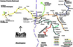
The CSP was built to tap the rolling, fertile hills of the Camas Prairie and the timber of the forested hills and canyonlands of the Clearwater River. [9] [10] Service to the south terminus of the second subdivision line at Grangeville commenced in December 1908, [7] and continued for 92 years.

The Camas Prairie Railroad was known as the "railroad on stilts" due to the many wooden trestles along its route. In one five-mile (8 km) stretch, there were more than a dozen trestles.

In addition to its wooden trestles, the railroad's second subdivision also had a sizable steel viaduct, 1,520 feet (460 m) in length with a maximum height of 280 feet (85 m). [11] [12] Bridge 38 spans Lawyer's Canyon, between Craigmont and Ferdinand, and is visible from U.S. Route 95.

Nezperce & Idaho Railroad

The Nezperce & Idaho Railroad (reporting mark NP&I) was an independently owned short line railroad that connected the community of Nezperce to the Camas Prairie Railroad. Primarily used to ship agricultural products it operated from 1910 until 1975, [13] [14] it was then used for boxcar storage until the 1980s. [13]

A water tower on the Camas Prairie Railroad in Lewiston, ID. Fat tank near Camas Prairie Railroad, Lewiston, ID. 2002 (10900113005).jpg
A water tower on the Camas Prairie Railroad in Lewiston, ID.

Demise

The railroad was sold to North American RailNet in April 1998, and it became the subsidiary Camas Prairie RailNet, Inc. (CSPR). After less than two years, CSPR notified the U.S. government in late 1999 that the second subdivision line to Grangeville could be subject to abandonment, citing lack of profitability. [15] [16] It made its formal request in May, [17] and it was approved by the Surface Transportation Board in September 2000; the last run to Fenn and Grangeville was on November 29. [18] [19] The tracks were to be removed shortly thereafter, but that was delayed as a new operator for the line was sought.

A train on Half Moon Trestle. (1909) TrainHalfMoon.jpg
A train on Half Moon Trestle. (1909)

When BG&CM stepped in to operate the second subdivision line in December 2002, it was originally only to extend from Spalding to Craigmont, [20] but a few weeks later decided to continue south, across Lawyer's Canyon to Cottonwood, stopping the salvage crews from going further north. [21] [22]

The tracks from Cottonwood to Grangeville were removed and salvaged in late 2002 and 2003. North American RailNet sold the remainder of the railroad to Watco in March 2004, [23] [24] which renamed it the Great Northwest Railroad.

In 2011, Bridge 21-3 was destroyed in a wildfire. Although BG&CM owner Mike Williams indicated plans to rebuild by spring of 2012 at the latest, [25] no construction has occurred.

By 2021 the tracks had been removed all the way from Grangeville to Ruebens.

Second subdivision

All locations in north central Idaho

  County  City / Stop  Mile  Elevation
feetm
Nez
Perce
Spalding 0805245
Lapwai 3.3955291
Sweetwater 5.31,090332
Culdesac 12.11,645501
Lewis Nucrag19.52,780847
Reubens 26.13,5251,074
Craigmont 34.43,7401,140
Idaho Ferdinand 42.33,7201,134
Cottonwood 51.03,4951,065
Fenn 59.53,275998
Grangeville 66.83,3951,035

Source: [17]

Passenger service

Passenger service on the main line along the Clearwater River to Stites and on the second subdivision to Grangeville was discontinued 69 years ago in August 1955. [26] [27]

The 1975 film Breakheart Pass starring Charles Bronson was filmed on portions of the railroad, as were parts of 1999's Wild Wild West.

Related Research Articles

<span class="mw-page-title-main">Nez Perce</span> Indigenous peoples of North America

The Nez Perce are an Indigenous people of the Plateau who still live on a fraction of the lands on the southeastern Columbia River Plateau in the Pacific Northwest. This region has been occupied for at least 11,500 years.

<span class="mw-page-title-main">Lewis County, Idaho</span> County in Idaho, United States

Lewis County is a county located in the north central region of the U.S. state of Idaho. As of the 2020 census, the population was 3,533, making it the fourth-least populous county in Idaho. The county seat is Nezperce, and Kamiah is the largest city. Partitioned from Nez Perce County and established in 1911, it was named after the explorer Meriwether Lewis. Most of the county is within the Nez Perce Indian Reservation, though Native Americans comprise less than 6% of the county population. Similar to the opening of lands in Oklahoma, the U.S. government opened the reservation for white settlement in November 1895. The proclamation had been signed less than two weeks earlier by President Cleveland.

<span class="mw-page-title-main">Idaho County, Idaho</span> County in Idaho, United States

Idaho County is a county in the U.S. state of Idaho, and the largest by area in the state. As of the 2020 census, the population was 16,541. The county seat is Grangeville. Previous county seats of the area were Florence (1864–68), Washington (1868–75), and Mount Idaho (1875–1902).

<span class="mw-page-title-main">Cottonwood, Idaho</span> City in the United States

Cottonwood is a city in Idaho County, Idaho. On the Camas Prairie in north central Idaho, the population was 900 at the 2010 census, down from 944 in 2000. It is just west of U.S. Route 95, between Grangeville and Lewiston.

<span class="mw-page-title-main">Ferdinand, Idaho</span> City in Idaho, United States

Ferdinand is a city in Idaho County, Idaho, United States. The population was 159 at the 2010 census, up from 145 in 2000. At the southern end of the Nez Perce Indian Reservation, it was founded by F.M. Bieker shortly after the reservation was opened for settlement in 1895. It was named after Ferdinand, Indiana, where his mother's family had lived.

<span class="mw-page-title-main">Grangeville, Idaho</span> City in Idaho, United States

Grangeville is the largest city in and the county seat of Idaho County, Idaho, United States, in the north central part of the state. Its population was 3,141 at the 2010 census, down from 3,228 in 2000.

<span class="mw-page-title-main">Kamiah, Idaho</span> City in Idaho, United States

Kamiah is a city in Lewis and Idaho counties in the U.S. state of Idaho. The largest city in Lewis County, it extends only a small distance into Idaho County, south of Lawyer Creek. The population was 1,295 at the 2010 census, up from 1,160 in 2000. The city lies in the narrow valley of the Clearwater River; downstream are Orofino and Lewiston, at the confluence with the Snake River.

<span class="mw-page-title-main">Kooskia, Idaho</span> City in Idaho, United States

Kooskia is a city in Idaho County, Idaho, United States. It is at the confluence of the South and Middle forks of the Clearwater River, combining to become the main river. The population was 607 at the 2010 census, down from 675 in 2000.

<span class="mw-page-title-main">Craigmont, Idaho</span> City in Idaho, United States

Craigmont is a city in the northwest United States in Lewis County, Idaho. Located on the Camas Prairie in north central Idaho, it is within the Nez Perce Indian Reservation. The population was 501 at the 2010 census, down from 556 in 2000.

<span class="mw-page-title-main">Winchester, Idaho</span> City in Idaho, United States

Winchester is a city in western Lewis County, Idaho, United States, located on the Camas Prairie in the north central part of the state. The population was 356 at the 2020 census, up from 340 in 2010.

<span class="mw-page-title-main">Lapwai, Idaho</span> City in Idaho, United States

Lapwai is a city in Nez Perce County, Idaho, United States. Its population was 1,137 at the 2010 census, and it is the seat of government of the Nez Perce Indian Reservation.

<span class="mw-page-title-main">Camas prairie</span>

The name camas prairie refers to several different geographical areas in the western United States which were named for the native perennial camassia or camas. The culturally and scientifically significant of these areas lie within Idaho and Montana. Camas bulbs were an important food source for Native Americans.

<span class="mw-page-title-main">Nez Perce National Historical Park</span> Series of federally protected historic sites in the northwestern United States

The Nez Perce National Historical Park is a United States National Historical Park comprising 38 sites located across the states of Idaho, Montana, Oregon, and Washington, which include traditional aboriginal lands of the Nez Perce people. The sites are strongly associated with the resistance of Chief Joseph and his band, who in June 1877 migrated from Oregon in an attempt to reach freedom in Canada and avoid being forced on to a reservation. They were pursued by U.S. Army cavalry forces and fought numerous skirmishes against them during the so-called Nez Perce War, which eventually ended with Chief Joseph's surrender in the Montana Territory.

Mount Idaho is a ghost town the western United States, located in Idaho County, Idaho. The town served as county seat of Idaho County from 1875 to 1902.

The BG&CM Railroad or Bountiful Grain and Craig Mountain Railroad is a Class III shortline railroad located in North Central Idaho.

<span class="mw-page-title-main">U.S. Route 95 in Idaho</span> Section of U.S. Highway in Idaho, United States

In the U.S. state of Idaho, U.S. Route 95 (US-95) is a north–south highway near the western border of the state, stretching from Oregon to British Columbia for over 538 miles (866 km); it was earlier known in the state as the North and South Highway.

<span class="mw-page-title-main">White Bird Hill Summit</span>

White Bird Hill Summit is a mountain pass in the northwest United States, located in north central Idaho on U.S. Highway 95. In Idaho County, it is midway between White Bird and Grangeville. The summit elevation of the highway is 4,245 feet (1,294 m) above sea level, through a substantial cut.

<span class="mw-page-title-main">Fort Lapwai</span> Historic fortification of the American Civil War in Idaho

Fort Lapwai (1862–1884), was a federal fort in present-day Lapwai in north central Idaho, United States. On the Nez Perce Indian Reservation in Nez Perce County, it was originally called Camp Lapwai until 1863. East of Lewiston, it was located on the west bank of Lapwai Creek, three miles (5 km) above where it joins the Clearwater River at the state's first settlement, Lapwai Mission Station, built in 1836 by Henry Spalding. It is part of the multi-site Nez Perce National Historical Park. The word "Lapwai" means place of the butterflies, as the area had thousands in early summer in earlier years.

Fenn is an unincorporated community in Idaho County, Idaho, United States. It is located on U.S. Route 95 on the Camas Prairie, seven miles (11 km) northwest of Grangeville and eight miles (13 km) south of Cottonwood. Fenn had a post office with ZIP code 83531.

The Great Northwest Railroad (GRNW) is located in North Central Idaho, and runs a mainline of approximately 77 miles (124 km). Known as the Camas Prairie Railroad until 1998 and then Camas Prairie Railnet, Watco purchased the line in 2004 and renamed it the GRNW.

References

  1. "Camas Prairie Railroad was born to squabbling parents". Lewiston Morning Tribune . Idaho. September 30, 1990. p. 12-centennial.
  2. Campbell, Thomas W. (July 16, 1961). "Wedding of rails provided spunky offspring". Lewiston Morning Tribune. Idaho. p. 5.
  3. Hamilton, Ladd (June 25, 1961). "Heads were popping up all over the place". Lewiston Morning Tribune. Idaho. p. 14.
  4. Brammer, Rhonda (July 24, 1977). "Unruly mobs dashed to grab land when reservation opened". Lewiston Morning Tribune. Idaho. p. 6E.
  5. "3,000 took part in "sneak" when Nez Perce Reservation was opened". Lewiston Morning Tribune. Idaho. November 19, 1931. p. 3.
  6. "Nez Perce Reservation". Spokesman-Review. Spokane, Washington. December 11, 1921. p. 5.
  7. 1 2 Hanrahan, R.E. (May 1, 1936). "Camas Prairie Railroad unique operating setup". Lewiston Morning Tribune. Idaho. p. 3.
  8. Campbell, Thomas J. (December 11, 1938). "Camas Prairie Railroad marks 30th anniversary". Lewiston Morning Tribune. Idaho. p. 12.
  9. "Come over and see us". Spokesman-Review. Spokane, Washington. February 27, 1895. p. 6.
  10. "Camas Prairie Railroad, unique system owned by competitors, is major industry in Lewiston". Lewiston Morning Tribune. Idaho. May 20, 1939. p. 3-sec.5.
  11. Renk, Nancy F.; Miss, C. J. (2002). "Camas Prairie Railroad, Second Subdivision" (PDF). Historic American Engineering Record . Washington, D.C.: Library of Congress. p. 6. Retrieved May 8, 2022.
  12. "CSP – Lawyers Canyon Viaduct". Bridgehunter.com. Retrieved July 12, 2017.
  13. 1 2 Askari, Mohsin (6 May 1990). "NEZPERCE-CRAIGMONT LINE SCRAP-METAL RAILROAD OWED ITS LIFE TO JOE LUX". The Lewiston Tribune. Retrieved 2021-06-02.
  14. "It's a Short Line, But a Long Story". The Lewiston Tribune. 22 August 2011. Retrieved 2021-06-02.
  15. Williams, Elaine (February 6, 2000). "Abandoning 66-mile stretch a step-by-step procedure". Lewiston Morning Tribune. Idaho. p. 1E.
  16. Williams, Elaine (August 21, 2000). "Severing ties". Lewiston Morning Tribune. Idaho. p. 1A.
  17. 1 2 "Legal notices: Camas Prairie RailNet, Inc". Lewiston Morning Tribune. Idaho. May 2, 2000. p. 9B.
  18. "Camas Prairie dream out of steam". Moscow-Pullman Daily News. Idaho-Washington. Associated Press. November 30, 2000. p. 2A.
  19. Walker, Jodi (December 31, 2000). "Some cracks in the foundation: Last train to Grangeville". Lewiston Morning Tribune. Idaho. p. 3A.
  20. Walker, Jodi (December 18, 2002). "Camas Prairie line will run again". Lewiston Morning Tribune. Idaho. p. 1A.
  21. Walker, Jodi (January 9, 2003). "Cottonwood has a railroad, again". Lewiston Morning Tribune. Idaho. p. 1A.
  22. Williams, Elaine (March 23, 2003). "Spalding line survives, barely". Lewiston Morning Tribune. Idaho. p. 1E.
  23. Williams, Elaine (February 17, 2004). "Railroad changing hands". Lewiston Morning Tribune. Idaho. p. 1A.
  24. Williames, Elaine (March 4, 2004). "Railroad changes hands, trains keep on running". Lewiston Morning Tribune. Idaho. p. 6A.
  25. Tribune, ERIC BARKER of the (10 September 2011). "Owner plans to rebuild rail trestle". The Lewiston Tribune. Retrieved 2021-06-01.
  26. "Camas Prairie trains stop". Spokane Daily Chronicle. Washington. Associated Press. August 24, 1955. p. b3.
  27. "Camas Prairie Railroad 'Bugs' reach end of the line today". Lewiston Morning Tribune. Idaho. August 23, 1955. p. 12.
External videos
Nuvola apps kaboodle.svg "Camas Prairie Railroad Cab Ride Trailer" on YouTube
Nuvola apps kaboodle.svg "Tribute to the Camas Prairie's 2nd Sub" on YouTube

46°14′N116°28′W / 46.24°N 116.47°W / 46.24; -116.47