Orofino, Idaho

Last updated

Orofino, Idaho
Clearwater River in Ahsahka, Idaho.jpg
Clearwater River near Orofino
Clearwater County Idaho Incorporated and Unincorporated areas Orofino Highlighted 1659320.svg
Location of Orofino in Clearwater County, Idaho.
Usa edcp location map.svg
Red pog.svg
Orofino, Idaho
Location in the United States
Coordinates: 46°29′8″N116°15′32″W / 46.48556°N 116.25889°W / 46.48556; -116.25889
Country United States
State Idaho
County Clearwater
Area
[1]
  Total2.61 sq mi (6.76 km2)
  Land2.46 sq mi (6.38 km2)
  Water0.15 sq mi (0.38 km2)
Elevation
1,030 ft (310 m)
Population
 (2010) [2]
  Total3,142
  Estimate 
(2019) [3]
3,099
  Density1,257.71/sq mi (485.63/km2)
Time zone UTC-8 (Pacific (PST))
  Summer (DST) UTC-7 (PDT)
ZIP code
83544
Area code 208
FIPS code 16-59320
GNIS feature ID0396986
Website www.cityoforofino.org
View of Orofino, 1931 Idaho - Lowman through Orofino - NARA - 23939453 (cropped).jpg
View of Orofino, 1931

Orofino ("fine gold" [ore] in Spanish) is a city in and the county seat of Clearwater County, [4] Idaho, United States, along Orofino Creek and the north bank of the Clearwater River. It is the major city within the Nez Perce Indian Reservation. The population was 3,142 at the time of the 2010 census.

Contents

Nearby is the historical "Canoe Camp," where the Lewis and Clark expedition built five new dugout canoes and embarked on October 7, 1805, downstream to the Pacific Ocean. Some four miles (6 km) north is the Dworshak Dam, third-highest dam in the United States, completed in the early 1970s. Nearby is the Dworshak National Fish Hatchery, started to try to compensate for the loss of migratory fish upstream after the dam was constructed.

Originally the name was two words, Oro Fino, applied to a gold mining camp established in 1861 two miles (3 km) south of Pierce. When the United States government opened up the Nez Percé reservation to non-tribal settlers in 1895, [5] [6] [7] [8] thousands of European Americans rushed to lay claims to land. Clifford Fuller set up a trading post on his new homestead. The town (Orofino-on-the-Clearwater) was established the next year. [9] The railroad, later part of the Camas Prairie Railroad, was constructed from Lewiston in 1899. [10]

Orofino is home to state institutions: Idaho State Hospital North and the Idaho Correctional Institution–Orofino. These two facilities are located adjacent to Orofino High School, which includes the junior high or middle school grades, and whose mascot is the Maniac.

Orofino hosts an annual July 4 celebration, as well as the Clearwater County Fair and Lumberjack Days in late summer. [11] Each spring, Boomershoot, an annual precision rifle event, is held nearby.

Geography

Orofino is located at 46°29′8″N116°15′32″W / 46.48556°N 116.25889°W / 46.48556; -116.25889 (46.485485, -116.258847). [12]

According to the United States Census Bureau, the city has a total area of 2.47 square miles (6.40 km2), of which 2.33 square miles (6.03 km2) is land and 0.14 square miles (0.36 km2) is water. [13]

Climate

The city has a climate typical of low-elevation areas in Idaho and eastern Washington. Orofino has a dry-summer continental climate (Köppen Dsb). Due to the warm summers, it nearly qualifies as a continental Mediterranean climate (Dsa). Idaho’s all-time highest temperature of 118 °F or 47.8 °C was recorded at Orofino on July 28, 1934.

Climate data for Orofino, Idaho (1971-2000)
MonthJanFebMarAprMayJunJulAugSepOctNovDecYear
Record high °F (°C)62
(17)
68
(20)
82
(28)
98
(37)
105
(41)
115
(46)
118
(48)
116
(47)
107
(42)
92
(33)
71
(22)
62
(17)
118
(48)
Mean daily maximum °F (°C)37.7
(3.2)
45.8
(7.7)
55.4
(13.0)
64.0
(17.8)
72.0
(22.2)
79.7
(26.5)
88.9
(31.6)
90.2
(32.3)
78.8
(26.0)
63.2
(17.3)
46.1
(7.8)
37.3
(2.9)
63.3
(17.4)
Mean daily minimum °F (°C)25.2
(−3.8)
28.0
(−2.2)
32.0
(0.0)
37.8
(3.2)
44.1
(6.7)
50.3
(10.2)
53.7
(12.1)
52.9
(11.6)
45.3
(7.4)
36.4
(2.4)
31.1
(−0.5)
26.2
(−3.2)
38.6
(3.7)
Record low °F (°C)−11
(−24)
−9
(−23)
12
(−11)
27
(−3)
28
(−2)
35
(2)
41
(5)
39
(4)
28
(−2)
15
(−9)
1
(−17)
−15
(−26)
−15
(−26)
Average precipitation inches (mm)2.91
(74)
2.66
(68)
2.53
(64)
2.40
(61)
2.59
(66)
1.67
(42)
1.06
(27)
0.88
(22)
1.24
(31)
1.98
(50)
3.38
(86)
3.29
(84)
26.59
(675)
Average snowfall inches (cm)12.0
(30)
3.9
(9.9)
1.3
(3.3)
0.1
(0.25)
0.0
(0.0)
0.0
(0.0)
0.0
(0.0)
0.0
(0.0)
0.0
(0.0)
0.0
(0.0)
1.3
(3.3)
7.9
(20)
26.5
(66.75)
Source 1: NOAA (normals, 1971-2000) [14]
Source 2: Western Regional Climate Centre (snowfall, 1948-1981) [15]

Demographics

Historical population
CensusPop.Note
1910 384
1920 53739.8%
1930 1,078100.7%
1940 1,60248.6%
1950 1,6563.4%
1960 2,47149.2%
1970 3,88357.1%
1980 3,711−4.4%
1990 2,868−22.7%
2000 3,24713.2%
2010 3,142−3.2%
2019 (est.)3,099 [3] −1.4%
U.S. Decennial Census [16]

2010 census

As of the census [2] of 2010, there were 3,142 people, 1,167 households, and 698 families residing in the city. The population density was 1,348.5 inhabitants per square mile (520.7/km2). There were 1,285 housing units at an average density of 551.5 per square mile (212.9/km2). The racial makeup of the city was 91.7% White, 0.5% African American, 2.5% Native American, 1.4% Asian, 0.3% Pacific Islander, 1.2% from other races, and 2.4% from two or more races. Hispanic or Latino of any race were 4.3% of the population.

There were 1,167 households, of which 24.3% had children under the age of 18 living with them, 46.4% were married couples living together, 9.3% had a female householder with no husband present, 4.2% had a male householder with no wife present, and 40.2% were non-families. 34.8% of all households were made up of individuals, and 17.5% had someone living alone who was 65 years of age or older. The average household size was 2.17 and the average family size was 2.77.

The median age in the city was 43.7 years. 17% of residents were under the age of 18; 7.2% were between the ages of 18 and 24; 27.3% were from 25 to 44; 28.3% were from 45 to 64; and 20.1% were 65 years of age or older. The gender makeup of the city was 58.3% male and 41.7% female.

2000 census

As of the census [17] of 2000, there were 3,247 people, 1,137 households, and 767 families residing in the city. The population density was 1,349.0 inhabitants per square mile (520.9/km2). There were 1,279 housing units at an average density of 531.4 per square mile (205.2/km2). The racial makeup of the city was 93.93% White, 0.37% African American, 2.13% Native American, 0.59% Asian, 0.09% Pacific Islander, 0.99% from other races, and 1.91% from two or more races. Hispanic or Latino of any race were 2.25% of the population.

There were 1,137 households, out of which 28.9% had children under the age of 18 living with them, 54.1% were married couples living together, 8.4% had a female householder with no husband present, and 32.5% were non-families. 27.6% of all households were made up of individuals, and 12.8% had someone living alone who was 65 years of age or older. The average household size was 2.33 and the average family size was 2.83.

In the city, the population was spread out, with 20.1% under the age of 18, 7.9% from 18 to 24, 30.4% from 25 to 44, 26.1% from 45 to 64, and 15.6% who were 65 years of age or older. The median age was 40 years. For every 100 females, there were 132.9 males. For every 100 females age 18 and over, there were 143.2 males.

The median income for a household in the city was $30,580, and the median income for a family was $36,908. Males had a median income of $30,386 versus $20,968 for females. The per capita income for the city was $14,563. About 7.6% of families and 12.1% of the population were below the poverty line, including 16.3% of those under age 18 and 7.1% of those age 65 or over.

Government and infrastructure

The city government is small due to the limited number of residents.

Major facilities are run by the state, which operates the Idaho State Hospital North here. In addition, the Idaho Department of Correction operates the Idaho Correctional Institution-Orofino here. [18] [19]

The United States Postal Service operates the Orofino Post Office. [20]

Transportation

The city is served by US 12, a two-lane undivided highway on the south bank of the Clearwater River, connected to Orofino by a bridge. The highway connects to Lewiston to the west and Missoula, Montana (over Lolo Pass) to the east. The route is known as the "Northwest Passage Scenic Byway," a National Scenic Byway. [21] The population is dependent on cars. Most areas have few or no sidewalks. Orofino Municipal Airport (KS68) is available for those traveling by small aircraft.

Related Research Articles

<span class="mw-page-title-main">Lewiston, Idaho</span> City in Idaho, United States

Lewiston is a city and the county seat of Nez Perce County, Idaho, United States, in the state's north central region. It is the third-largest city in the northern Idaho region, behind Post Falls and Coeur d'Alene, and the twelfth-largest in the state. Lewiston is the principal city of the Lewiston, ID-WA Metropolitan Statistical Area, which includes all of Nez Perce County and Asotin County, Washington. As of the 2020 census, the population of Lewiston was 34,203, up from 31,894 in 2010.

<span class="mw-page-title-main">Nez Perce County, Idaho</span> County in Idaho, United States

Nez Perce County is a county located in the U.S. state of Idaho. As of the 2020 census, the population was 42,090. The county seat is Lewiston. The county is named after the Native American Nez Percé tribe. Nez Perce County is part of the Lewiston, Idaho–WA Metropolitan Statistical Area.

<span class="mw-page-title-main">Wallowa County, Oregon</span> County in Oregon, United States

Wallowa County is the northeastern most county in the U.S. state of Oregon. As of the 2020 census, the population was 7,391, making it Oregon's fifth-least populous county. Its county seat is Enterprise. According to Oregon Geographic Names, the origins of the county's name are uncertain, with the most likely explanation being it is derived from the Nez Perce term for a structure of stakes used in fishing. An alternative explanation is that Wallowa is derived from a Nez Perce word for "winding water". The journals of Lewis and Clark Expedition record the name of the Wallowa River as Wil-le-wah.

<span class="mw-page-title-main">Shoshone County, Idaho</span> County in Idaho, United States

Shoshone County is a county in the U.S. state of Idaho. As of the 2020 census, the population was 13,169. The county seat is Wallace and the largest city is Kellogg. The county was established in 1864, named for the Native American Shoshone tribe.

<span class="mw-page-title-main">Lewis County, Idaho</span> County in Idaho, United States

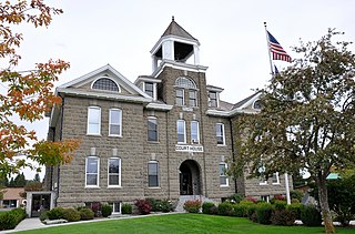
Lewis County is a county located in the north central region of the U.S. state of Idaho. As of the 2020 census, the population was 3,533, making it the fourth-least populous county in Idaho. The county seat is Nezperce, and Kamiah is the largest city. Partitioned from Nez Perce County and established in 1911, it was named after the explorer Meriwether Lewis. Most of the county is within the Nez Perce Indian Reservation, though Native Americans comprise less than 6% of the county population. Similar to the opening of lands in Oklahoma, the U.S. government opened the reservation for white settlement in November 1895. The proclamation had been signed less than two weeks earlier by President Cleveland.

<span class="mw-page-title-main">Latah County, Idaho</span> County in Idaho, United States

Latah County is a county located in the north central region of the U.S. state of Idaho. As of the 2020 census, the population was 39,517. The county seat and largest city is Moscow, the home of the University of Idaho, the state's flagship university.

<span class="mw-page-title-main">Idaho County, Idaho</span> County in Idaho, United States

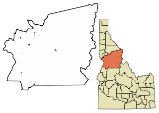
Idaho County is a county in the U.S. state of Idaho, and the largest by area in the state. As of the 2020 census, the population was 16,541. The county seat is Grangeville. Previous county seats of the area were Florence (1864–68), Washington (1868–75), and Mount Idaho (1875–1902).

<span class="mw-page-title-main">Clearwater County, Idaho</span> County in Idaho, United States

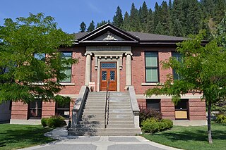
Clearwater County is a county located in the U.S. state of Idaho. As of the 2020 census, the population was 8,734. The county seat is Orofino. Established in 1911, the county was named after the Clearwater River.

<span class="mw-page-title-main">Pierce, Idaho</span> City in Idaho, United States

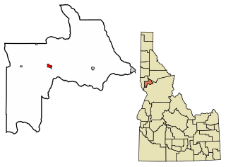
Pierce is a city in the northwest United States, located in Clearwater County, Idaho. The population was 508 at the 2010 census, down from 617 in 2000.

<span class="mw-page-title-main">Ferdinand, Idaho</span> City in Idaho, United States

Ferdinand is a city in Idaho County, Idaho, United States. The population was 159 at the 2010 census, up from 145 in 2000. At the southern end of the Nez Perce Indian Reservation, it was founded by F.M. Bieker shortly after the reservation was opened for settlement in 1895. It was named after Ferdinand, Indiana, where his mother's family had lived.

<span class="mw-page-title-main">Kamiah, Idaho</span> City in Idaho, United States

Kamiah is a city in Lewis and Idaho counties in the U.S. state of Idaho. The largest city in Lewis County, it extends only a small distance into Idaho County, south of Lawyer Creek. The population was 1,295 at the 2010 census, up from 1,160 in 2000. The city lies in the narrow valley of the Clearwater River; downstream are Orofino and Lewiston, at the confluence with the Snake River.

<span class="mw-page-title-main">Kooskia, Idaho</span> City in Idaho, United States

Kooskia is a city in Idaho County, Idaho, United States. It is at the confluence of the South and Middle forks of the Clearwater River, combining to become the main river. The population was 607 at the 2010 census, down from 675 in 2000.

<span class="mw-page-title-main">White Bird, Idaho</span> Town in Idaho, United States

White Bird is a city in Idaho County, Idaho. The population was 91 at the time of the 2010 census, down from 106 in 2000.

<span class="mw-page-title-main">Genesee, Idaho</span> City in Idaho, United States

Genesee is a city in Latah County, Idaho, United States. The population was 955 at the 2010 census, up from 946 in 2000. The city was named for the Genesee region of western New York, although it may also be a modification of the biblical Genesis.

<span class="mw-page-title-main">Craigmont, Idaho</span> City in Idaho, United States

Craigmont is a city in the northwest United States in Lewis County, Idaho. Located on the Camas Prairie in north central Idaho, it is within the Nez Perce Indian Reservation. The population was 501 at the 2010 census, down from 556 in 2000.

<span class="mw-page-title-main">Winchester, Idaho</span> City in Idaho, United States

Winchester is a city in western Lewis County, Idaho, United States, located on the Camas Prairie in the north central part of the state. The population was 356 at the 2020 census, up from 340 in 2010.

<span class="mw-page-title-main">Culdesac, Idaho</span> City in Idaho, United States

Culdesac is a city in Nez Perce County, Idaho, United States. The population was 380 at the 2010 census. It is part of the Lewiston, ID-WA Metropolitan Statistical Area.

<span class="mw-page-title-main">Lapwai, Idaho</span> City in Idaho, United States

Lapwai is a city in Nez Perce County, Idaho, United States. Its population was 1,137 at the 2010 census, and it is the seat of government of the Nez Perce Indian Reservation.

<span class="mw-page-title-main">Peck, Idaho</span> City in Idaho, United States

Peck is a city in Nez Perce County, Idaho, United States. The population was 197 at the 2010 census. It is part of the Lewiston, ID-WA Metropolitan Statistical Area. Many residents of Peck work in nearby Orofino, Idaho. Additionally, Peck residents attend high school in Orofino since Peck does not have a high school.

Greer is an unincorporated community in Clearwater County, Idaho, on the Nez Perce Indian Reservation. Greer is located along the Clearwater River and Idaho State Highway 11, near the junction with U.S. Route 12, seven miles (11 km) southeast of Orofino.

References

  1. "2019 U.S. Gazetteer Files". United States Census Bureau. Retrieved July 9, 2020.
  2. 1 2 "U.S. Census website". United States Census Bureau . Retrieved December 18, 2012.
  3. 1 2 "Population and Housing Unit Estimates". United States Census Bureau. May 24, 2020. Retrieved May 27, 2020.
  4. "Find a County". National Association of Counties. Retrieved June 7, 2011.
  5. Hamilton, Ladd (June 25, 1961). "Heads were popping up all over the place". Lewiston Morning Tribune. p. 14.
  6. Brammer, Rhonda (July 24, 1977). "Unruly mobs dashed to grab land when reservation opened". Lewiston Morning Tribune. p. 6E.
  7. "3,000 took part in "sneak" when Nez Perce Reservation was opened". Lewiston Morning Tribune. November 19, 1931. p. 3.
  8. "Nez Perce Reservation". Spokesman-Review. December 11, 1921. p. 5.
  9. "Why they call it Orofino". Lewiston Morning Tribune. February 26, 1933. p. 4.
  10. Idaho for the Curious, by Cort Conley, ©1982, ISBN   0-9603566-3-0, p.95-97
  11. "Three loggers share all-around Lumberjack Days championship". Lewiston Morning Tribune. September 17, 1962. p. 12.
  12. "US Gazetteer files: 2010, 2000, and 1990". United States Census Bureau. February 12, 2011. Retrieved April 23, 2011.
  13. "US Gazetteer files 2010". United States Census Bureau. Archived from the original on July 2, 2012. Retrieved December 18, 2012.
  14. "Climatography of the United States NO.81" (PDF). National Oceanic and Atmospheric Administration . Retrieved March 21, 2018.
  15. "Idaho wrcc". Western Regional Climate Center . Retrieved March 8, 2021.
  16. "Census of Population and Housing". Census.gov. Retrieved June 4, 2015.
  17. "U.S. Census website". United States Census Bureau . Retrieved January 31, 2008.
  18. "Locations." Idaho Department of Correction. Retrieved on June 4, 2011. "Idaho Correctional Institution-Orofino (ICIO), 381 West Hospital Drive, Orofino, ID 83544 "
  19. "Orofino city, Idaho Archived 2011-11-24 at the Wayback Machine ." U.S. Census Bureau. Retrieved on June 4, 2011.
  20. "Post Office™ Location - OROFINO Archived 2012-08-30 at the Wayback Machine ." United States Postal Service. Retrieved on June 4, 2011.
  21. Idaho Byways - Northwest Passage Scenic Byway Archived 2013-06-25 at the Wayback Machine