
Burkittsville is a historic village in Frederick County, Maryland, United States. The village lies in the southern Middletown Valley along the eastern base of South Mountain.

Sharpsburg is a town in Washington County, Maryland. The town is approximately 13 miles (21 km) south of Hagerstown. Its population was 705 at the 2010 census.
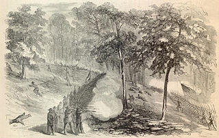
The Battle of South Mountain, known in several early Southern accounts as the Battle of Boonsboro Gap, was fought on September 14, 1862, as part of the Maryland campaign of the American Civil War. Three pitched battles were fought for possession of three South Mountain passes: Crampton's, Turner's, and Fox's Gaps.

Kennesaw Battlefield Park preserves a Civil War battleground of the Atlanta Campaign, and also contains Kennesaw Mountain. It is located at 900 Kennesaw Mountain Drive, between Marietta and Kennesaw, Georgia. The name "Kennesaw" derives from the Cherokee Indian "Gah-nee-sah" meaning "cemetery" or burial ground. The area was designated as a U.S. historic district on October 15, 1966.

Crampton's Gap, also known as Crampton Gap, is a wind gap on South Mountain in Maryland.
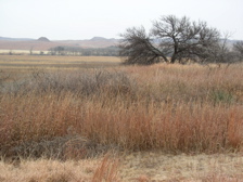
Washita Battlefield National Historic Site protects and interprets the site of the Southern Cheyenne village of Chief Black Kettle where the Battle of Washita occurred. The site is located about 150 miles (241 km) west of Oklahoma City, Oklahoma, near Cheyenne, Oklahoma. Just before dawn on November 27, 1868, the village was attacked by the 7th U.S. Cavalry under Lt. Col. George Custer. In the Battle of Washita, the Cheyenne suffered large numbers of casualties. The strike was hailed at the time by the military and many civilians as a significant victory aimed at reducing Indian raids on frontier settlements as it forced the Cheyenne back to the reservation set aside for them. The site is a small portion of a large area that was declared a National Historic Landmark in 1965, and was listed on the National Register of Historic Places in 1966. The landmarked area encompasses the entire battlefield, which extends for some 6 miles (9.7 km) through the city of Cheyenne.
Brices Cross Roads National Battlefield Site memorializes the Battle of Brice's Cross Roads, in which a U.S. Army force was defeated by a smaller Confederate force commanded by Major-General Nathan Bedford Forrest on June 10, 1864, but nonetheless secured Union supply lines between Nashville and Chattanooga, Tennessee.

Turner's Gap is a wind gap in the South Mountain Range of the Blue Ridge Mountains, located in Frederick County and Washington County, Maryland. The gap is traversed by U.S. Route 40 Alternate, the old National Pike. The Appalachian Trail also crosses the gap along the ridgeline.
The Battle of Crampton's Gap, or Battle of Burkittsville, was a battle fought between forces under Confederate Brig. Gen. Howell Cobb and Union Maj. Gen. William B. Franklin as part of the Battle of South Mountain on September 14, 1862, at Crampton's Gap in Western Maryland, during the Maryland Campaign of the American Civil War.

Maryland Route 17 is a state highway in the U.S. state of Maryland. The state highway begins at the Virginia state line at the Potomac River in Brunswick, where the highway continues south as Virginia State Route 287. MD 17 runs 29.49 miles (47.46 km) north from the Brunswick Bridge to the Frederick–Washington county line near Wolfsville. The state highway serves as the main north–south highway of the Middletown Valley of western Frederick County. MD 17 connects Brunswick and Wolfsville with Rosemont, Burkittsville, Middletown, and Myersville. The state highway also connects those communities with the valley's main east–west highways, which include U.S. Route 340, US 40 Alternate, Interstate 70 (I-70), and US 40.

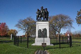
Gathland State Park is a public recreation area and historic preserve located on South Mountain near Burkittsville, Maryland, in the United States. The state park occupies the former estate of war correspondent George Alfred Townsend (1841-1914), who wrote under the pen name "Gath" during the American Civil War. The estate's few remaining original structures include the War Correspondents Memorial Arch, which sits alongside the Appalachian Trail. The park is operated by the Maryland Department of Natural Resources. The arch is a National Historic Monument maintained by the National Park Service.

George Alfred Townsend was an American journalist and novelist. He worked as a war correspondent during the American Civil War. Townsend wrote under the pen name "Gath", which was derived by adding an "H" to his initials, and inspired by the biblical passage II Samuel 1:20, "Tell it not in Gath, publish it not in the streets of Askalon."
The Fallen Timbers Battlefield was the site of the Battle of Fallen Timbers on 20 August 1794. The battle, a decisive American victory over Native American and British opponents, effectively ended the Northwest Indian War, securing the Old Northwest for settlement. An area believed to be the battle site, located in Maumee, Ohio, was declared a National Historic Landmark in 1960. That site, now the Fallen Timbers State Memorial, is about 0.25 miles (0.40 km) south of the actual battlefield, which was identified in 1995, and much of which is now preserved as part of the Fallen Timbers Battlefield and Fort Miamis National Historic Site along with Fort Miami. The National Historic Site was established in 1999 as a partnership between the National Park Service, Toledo MetroParks, and the Ohio Historical Society.

The Petersburg Breakthrough Battlefield is a historic district in Dinwiddie County, near Petersburg, Virginia. It was the location of the Third Battle of Petersburg, in which the Union Army broke through Confederate Army lines protecting Petersburg and Richmond on April 2, 1865, during the American Civil War. The success of the breakthrough led to abandonment of Richmond by General Robert E. Lee, a general retreat, and surrender at Appomattox Court House one week later. Portions of the area were listed on the National Register of Historic Places in 2003, and a different portion was designated a National Historic Landmark in 2006. Much of the battlefield area is part of Pamplin Historical Park, a private park open to the public that interprets the battle. The park includes a full-service visitor center, trails, displays, interpretive signs and history programs. The Civil War Trust and its partners have acquired and preserved 407 acres (1.65 km2) of the Breakthrough battlefield in five transactions since 2004.
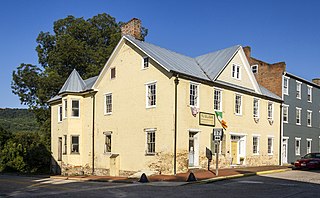
The Burkittsville Historic District comprises the small town of Burkittsville, Maryland. Located at a crossroads in western Frederick County, the town is a consistent collection of early 19th-century Federal style houses mixed with a few Victorian style houses that has remained virtually unchanged since 1900. The town is surrounded on three sides by an open, farmed landscape, and nestles against South Mountain on its western side.

The River Raisin National Battlefield Park preserves the site of the Battle of Frenchtown as the only national battlefield marking a site of the War of 1812. It was established as the 393rd unit of the United States National Park Service under Title VII of the Omnibus Public Land Management Act, which was signed into law on March 30, 2009. The park is located in the city of Monroe in Monroe County, Michigan. It was designated as a Michigan Historic Site on February 18, 1956 and was added to the National Register of Historic Places on December 10, 1982. The house at 1403 East Elm Avenue was added to the National Register listing in 2019. It officially began operation as a national park unit on October 22, 2010.

Fox's Gap, also known as Fox Gap, is a wind gap in the South Mountain Range of the Blue Ridge Mountains, located in Frederick County and Washington County, Maryland. The gap is traversed by Reno Monument Road. The Appalachian Trail also crosses the gap along the ridgeline.

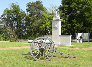
The Turner's and Fox's Gaps Historic District comprises the Civil War-era battlefield involved in the Battle of South Mountain, which took place on September 14, 1862. The district extends on the west to the slopes of South Mountain in the area of Zittlestown, and to the east beyond the foot of the mountain to the small community of Bolivar. The district is characterized by steep mountain terrain in the west and open farmland in the east, with Turner's Gap to the north and Fox's Gap to the south. The district includes 115 contributing buildings and structures. The most significant contributing buildings are the Mountain House Inn and the White House Inn, or Beachley House. Also included in the list is the Reno Monument at Fox's Gap, shown at right. The Old National Pike, now known as U.S. 40 Alternate, passes over South Mountain at Turner's Gap.

The Ringgold Gap Battlefield, in Catoosa County, Georgia, preserves the scene of the Battle of Ringgold Gap in the American Civil War.
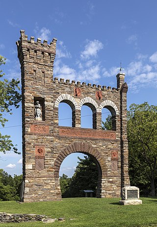
The National War Correspondents Memorial, part of Gathland State Park, is a memorial dedicated to journalists who died in war. It is located at Crampton's Gap at South Mountain, near Burkittsville, Maryland, in the United States.


