Crane, Indiana

Last updated

Crane, Indiana
Crane-558-Blandy-in.jpg
Crane NSA Visitor's Center (right) and the Lonely Night Saloon (left)
Martin County Indiana Incorporated and Unincorporated areas Crane Highlighted 1815652.svg
Location in Martin County, Indiana
Coordinates: 38°53′39″N86°54′05″W / 38.89417°N 86.90139°W / 38.89417; -86.90139
Country United States
State Indiana
County Martin
Township Perry
Area
[1]
  Total0.12 sq mi (0.31 km2)
  Land0.12 sq mi (0.31 km2)
  Water0.00 sq mi (0.00 km2)
Elevation
[2]
597 ft (182 m)
Population
 (2020) [3]
  Total166
  Density1,383.33/sq mi (532.46/km2)
Time zone UTC-5 (Eastern (EST))
  Summer (DST) UTC-5 (EST)
ZIP code
47522
Area code(s) 812 and 930
FIPS code 18-15652 [4]
GNIS feature ID2396667 [2]

Crane is a town in Perry Township, Martin County, in the U.S. state of Indiana. [2] The population was 166 at the 2020 census. The community is adjacent to the Naval Surface Warfare Center Crane Division.

Contents

History

Crane was originally known as "Burns City Ammunition Depot", and under the latter name was founded in 1940. [5] In 1943, the community was renamed "Crane", in honor of William M. Crane, first chief of the Navy Bureau of Ordnance. [6]

Geography

Crane is located in the northwest corner of Martin County. The western border of the town follows the Daviess County line. The Naval Surface Warfare Center Crane Division occupies the areas east of Crane (a visitor center lies within the town). Indiana State Road 558 passes through the southern part of Crane, connecting the town with U.S. Route 231 to the west. Interstate 69 passes just north of Crane.

According to the U.S. Census Bureau, Crane has a total area of 0.12 square miles (0.31 km2), all of it recorded as land. [1] Culpepper Branch has its headwaters in Crane and flows southeast to First Creek, which turns and flows west to join the White River at Newberry.

Demographics

Historical population
CensusPop.Note
1970 339
1980 297−12.4%
1990 216−27.3%
2000 203−6.0%
2010 184−9.4%
2020 166−9.8%
U.S. Decennial Census [7]

2010 census

As of the census [8] of 2010, there were 184 people, 80 households, and 43 families living in the town. The population density was 1,533.3 inhabitants per square mile (592.0/km2). There were 109 housing units at an average density of 908.3 per square mile (350.7/km2). The racial makeup of the town was 96.7% White and 3.3% Asian.

There were 80 households, of which 27.5% had children under the age of 18 living with them, 36.3% were married couples living together, 11.3% had a female householder with no husband present, 6.3% had a male householder with no wife present, and 46.3% were non-families. 43.8% of all households were made up of individuals, and 13.8% had someone living alone who was 65 years of age or older. The average household size was 2.30 and the average family size was 3.12.

The median age in the town was 39.4 years. 26.1% of residents were under the age of 18; 5.4% were between the ages of 18 and 24; 25.5% were from 25 to 44; 26.7% were from 45 to 64; and 16.3% were 65 years of age or older. The gender makeup of the town was 48.4% male and 51.6% female.

2000 census

As of the census [4] of 2000, there were 203 people, 89 households, and 54 families living in the town. The population density was 1,705.4 inhabitants per square mile (658.5/km2). There were 112 housing units at an average density of 940.9 per square mile (363.3/km2). The racial makeup of the town was 97.04% White, 0.49% Asian, and 2.46% from two or more races. Hispanic or Latino of any race were 0.49% of the population.

There were 89 households, out of which 24.7% had children under the age of 18 living with them, 49.4% were married couples living together, 6.7% had a female householder with no husband present, and 39.3% were non-families. 31.5% of all households were made up of individuals, and 12.4% had someone living alone who was 65 years of age or older. The average household size was 2.28 and the average family size was 2.93.

In the town, the population was spread out, with 27.1% under the age of 18, 2.0% from 18 to 24, 21.2% from 25 to 44, 28.6% from 45 to 64, and 21.2% who were 65 years of age or older. The median age was 44 years. For every 100 females, there were 89.7 males. For every 100 females age 18 and over, there were 92.2 males.

The median income for a household in the town was $36,250, and the median income for a family was $45,625. Males had a median income of $33,750 versus $27,500 for females. The per capita income for the town was $16,853. About 9.6% of families and 13.6% of the population were below the poverty line, including 26.9% of those under the age of eighteen and 3.0% of those 65 or over.

Numbered highways

Related Research Articles

<span class="mw-page-title-main">St. Leon, Indiana</span> Town in Indiana, United States

St. Leon or Saint Leon is a town in Kelso Township, Dearborn County, Indiana, United States. The population was 678 at the 2010 census.

<span class="mw-page-title-main">West Harrison, Indiana</span> Town in Indiana, United States

West Harrison is a town in Harrison Township, Dearborn County, Indiana, United States. The population was 289 at the 2010 census.

<span class="mw-page-title-main">St. Paul, Indiana</span> Town in Indiana, United States

St. Paul or Saint Paul is a small town on the border of Decatur and Shelby counties in the U.S. state of Indiana. The population was 1,031 at the 2010 census.

<span class="mw-page-title-main">Ashley, Indiana</span> Town in Indiana, United States

Ashley is a town in Indiana located on the border of Smithfield Township, DeKalb County and Steuben Township, Steuben County. The population was 983 at the 2010 census.

<span class="mw-page-title-main">McCordsville, Indiana</span> Town in Indiana, United States

McCordsville is a town in Vernon Township, Hancock County, Indiana, United States. The town is a fast-growing suburb of Indianapolis with an estimated population of 8,592 in 2020.

<span class="mw-page-title-main">Wilkinson, Indiana</span> Town in Indiana, United States

Wilkinson is a town in Brown Township, Hancock County, Indiana, United States. The population was 449 at the 2010 census.

<span class="mw-page-title-main">Stilesville, Indiana</span> Town in Indiana, United States

Stilesville is a town in Franklin Township, Hendricks County, Indiana, United States. The population was 316 at the 2010 Census.

<span class="mw-page-title-main">Andrews, Indiana</span> Town in Indiana, United States

Andrews is a town in Dallas Township, Huntington County, Indiana, United States. The population was 1,048 at the 2020 census.

<span class="mw-page-title-main">Sidney, Indiana</span> Town in Indiana, United States

Sidney is a town in Jackson Township, Kosciusko County, in the U.S. state of Indiana. The population was 83 at the 2010 census.

<span class="mw-page-title-main">Edgewood, Indiana</span> Town in Indiana, United States

Edgewood is a town in Anderson Township, Madison County, Indiana, United States. It is part of the Indianapolis–Carmel–Anderson metropolitan statistical area. The population was 2,053 at the 2020 census.

<span class="mw-page-title-main">Woodlawn Heights, Indiana</span> Town in Indiana, United States

Woodlawn Heights is a town in Anderson Township, Madison County, Indiana, United States. It is part of the Indianapolis–Carmel–Anderson metropolitan statistical area. The population was 91 at the 2020 census.

<span class="mw-page-title-main">Wingate, Indiana</span> Town in Indiana, United States

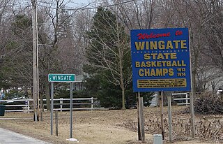
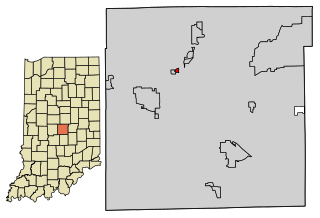
Wingate, formerly known as "Pleasant Hill", is a town in Coal Creek Township, Montgomery County, in the U.S. state of Indiana. The population was 237 at the 2020 census.

<span class="mw-page-title-main">Bethany, Indiana</span> Town in Indiana, United States

Bethany is a town in Clay Township, Morgan County, in the U.S. state of Indiana. The population was 95 at the 2020 census.

<span class="mw-page-title-main">Paragon, Indiana</span> Town in Indiana, United States

Paragon is a town in Ray Township, Morgan County, in the U.S. state of Indiana. The population was 556 at the 2020 census, down from 659 in 2010.

<span class="mw-page-title-main">Fillmore, Indiana</span> Town in Indiana, United States

Fillmore is a town in Marion Township, Putnam County, in the U.S. state of Indiana. The population was 532 at the 2020 census.

<span class="mw-page-title-main">Clear Lake, Indiana</span> Town in Indiana, United States

Clear Lake is a town located in the northeast corner of Steuben County, Indiana, in Clear Lake Township. As such, is the northeasternmost community in the State of Indiana. The population was 339 at the 2010 census.

<span class="mw-page-title-main">Mount Auburn, Indiana</span> Town in Indiana, United States

Mount Auburn is a town in Jackson Township, Wayne County, in the U.S. state of Indiana. The population was 117 at the 2010 census. The town is sandwiched between Dublin and Cambridge City.

<span class="mw-page-title-main">North Crows Nest, Indiana</span> Town in Indiana, United States

North Crows Nest is a town in Washington Township, Marion County, Indiana, United States. It is approximately 7 miles (11 km) north of downtown Indianapolis. The population was 44 at the 2020 census. It has existed as an "included town" since 1970, when it was incorporated into Indianapolis as part of Unigov. It is part of Indianapolis, but retains town governmental powers under IC 36-3-1-11.

<span class="mw-page-title-main">Spring Hill, Indiana</span> Town in Indiana, United States

Spring Hill is a town in Marion County, Indiana, United States. The population was 95 at the 2020 census. It has existed as an "included town" since 1970, when it was incorporated into Indianapolis as part of Unigov. It is part of Indianapolis, but retains town governmental powers under IC 36-3-1-11.

<span class="mw-page-title-main">Wynnedale, Indiana</span> Town in Indiana, United States

Wynnedale is a town in Washington Township, Marion County, Indiana, United States. The population was 215 at the 2020 census. It has existed as an "included town" since 1970, when it was incorporated into Indianapolis as part of Unigov. It is part of Indianapolis, but retains a functioning town government under IC 36-3-1-11.

References

  1. 1 2 "2022 U.S. Gazetteer Files: Indiana". United States Census Bureau. Retrieved April 17, 2023.
  2. 1 2 3 U.S. Geological Survey Geographic Names Information System: Crane, Indiana
  3. "P1. Race – Crane town, Indiana: 2020 DEC Redistricting Data (PL 94-171)". U.S. Census Bureau. Retrieved April 17, 2023.
  4. 1 2 "U.S. Census website". United States Census Bureau . Retrieved January 31, 2008.
  5. Baker, Ronald L. (October 1995). From Needmore to Prosperity: Hoosier Place Names in Folklore and History . Indiana University Press. p.  104. ISBN   978-0-253-32866-3. In 1940 this area first was called the Burns City Ammunition Depot...
  6. Rund, Christopher; Frailey, Fred W.; Powell, Eric (September 2011). The Indiana Rail Road Company: America's New Regional Railroad. Indiana University Press. p. 264. ISBN   0-253-35695-4.
  7. "Census of Population and Housing". Census.gov. Retrieved June 4, 2015.
  8. "U.S. Census website". United States Census Bureau . Retrieved December 11, 2012.