Martin County, Indiana

Last updated

Martin County
Martin County Indiana Courthouse.jpg
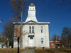
Martin County Courthouse
Map of Indiana highlighting Martin County.svg
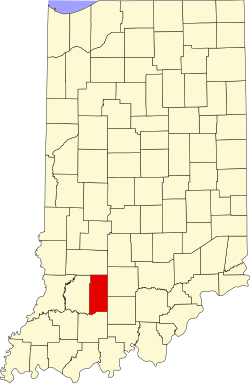
Location within the U.S. state of Indiana
Indiana in United States.svg
Indiana's location within the U.S.
Coordinates: 38°43′N86°48′W / 38.71°N 86.8°W / 38.71; -86.8
CountryFlag of the United States.svg United States
StateFlag of Indiana.svg  Indiana
FoundedJanuary 20, 1820
Named for Major John T. Martin
Seat Shoals
Largest city Loogootee
Area
  Total340.41 sq mi (881.7 km2)
  Land335.74 sq mi (869.6 km2)
  Water4.67 sq mi (12.1 km2)  1.37%
Population
 (2020)
  Total9,812
  Density29/sq mi (11/km2)
Time zone UTC−5 (Eastern)
  Summer (DST) UTC−4 (EDT)
Congressional district 8th
Website martincountyindiana.com
Indiana county number 51

Martin County is a county in the U.S. state of Indiana. As of the 2020 United States Census, the population was 9,812. [1] The county seat is Shoals at the center of the county, [2] and the county's only incorporated city is Loogootee, on the county's western border. [3]

Contents

History

The Indiana Territory achieved statehood near the end of 1816. Shortly thereafter, the new State legislature created Dubois (December 1817) and Daviess (February 1818) counties. Due to the inflow of settlers into southwest Indiana, and the difficulty of accessing the county seats of those counties, Martin County was partitioned off from parts of those counties, being authorized on January 20, 1820. It was named for Maj. John T. Martin of Newport, Kentucky. [4] [5]

Geography

The hills of Martin County are largely wooded and cut with drainages; [3] the available area is devoted to agriculture, development, or is under control of the US Government - about a third of the county belongs to the Naval Surface Warfare Center Crane Division, and about a quarter of the county belongs to Hoosier National Forest. The highest point (870 feet/270 meters ASL) is in Mitcheltree Township, within NSA Crane. [6]

The East Fork of the White River flows southwestward through the lower part of the county. The central part of the county is drained by Indian Creek, which discharges into White River near the center of the county. The upper part of the county is drained by Boggs Creek, which discharges into White River near the county's western edge. [3]

According to the 2010 census, the county has a total area of 340.41 square miles (881.7 km2), of which 335.74 square miles (869.6 km2) (or 98.63%) is land and 4.67 square miles (12.1 km2) (or 1.37%) is water. [7]

Adjacent counties

Protected areas

Lakes

Highways

City and towns

Unincorporated communities

Townships

Climate and weather

Shoals, Indiana
Climate chart (explanation)
J
F
M
A
M
J
J
A
S
O
N
D
 
 
3.2
 
 
37
19
 
 
2.9
 
 
43
22
 
 
4.3
 
 
54
31
 
 
4.5
 
 
65
40
 
 
5.6
 
 
75
50
 
 
4.2
 
 
83
59
 
 
4.7
 
 
86
64
 
 
3.8
 
 
85
62
 
 
3.4
 
 
79
54
 
 
3.1
 
 
68
42
 
 
4.5
 
 
54
34
 
 
3.5
 
 
42
24
Average max. and min. temperatures in °F
Precipitation totals in inches
Source: The Weather Channel [9]
Metric conversion
J
F
M
A
M
J
J
A
S
O
N
D
 
 
80
 
 
3
−7
 
 
74
 
 
6
−6
 
 
108
 
 
12
−1
 
 
114
 
 
18
4
 
 
142
 
 
24
10
 
 
108
 
 
28
15
 
 
120
 
 
30
18
 
 
96
 
 
29
17
 
 
85
 
 
26
12
 
 
80
 
 
20
6
 
 
114
 
 
12
1
 
 
90
 
 
6
−4
Average max. and min. temperatures in °C
Precipitation totals in mm

In recent years, average temperatures in Shoals have ranged from a low of 19 °F (−7 °C) in January to a high of 86 °F (30 °C) in July, although a record low of −23 °F (−31 °C) was recorded in January 1994 and a record high of 104 °F (40 °C) was recorded in July 1954. Average monthly precipitation ranged from 2.92 inches (74 mm) in February to 5.60 inches (142 mm) in May. [9]

Government

The county government is a constitutional body, and is granted specific powers by the Constitution of Indiana, and by the Indiana Code.

County Council: The legislative branch of the county government; controls spending and revenue collection in the county. Representatives are elected to four-year terms from county districts. They are responsible for setting salaries, the annual budget, and special spending. The council has limited authority to impose local taxes, in the form of an income and property tax that is subject to state level approval, excise taxes, and service taxes. [10] [11]

Board of Commissioners: The executive body of the county; commissioners are elected county-wide to staggered four-year terms. One commissioner serves as president. The commissioners execute the acts legislated by the council, collect revenue, and manage the county government. [10] [11]

Court: The county maintains a small claims court that handles civil cases. The judge on the court is elected to a term of four years and must be a member of the Indiana Bar Association. The judge is assisted by a constable who is also elected to a four-year term. In some cases, court decisions can be appealed to the state level circuit court. [11]

County Officials: The county has other elected offices, including sheriff, coroner, auditor, treasurer, recorder, surveyor, and circuit court clerk. Officers are elected to four-year terms. Members elected to county government positions are required to declare party affiliations and to be residents of the county. [11]

Martin County is part of Indiana's 8th congressional district; Indiana Senate district 39; [12] and Indiana House of Representatives districts 62 and 63. [13]

Political Culture

United States presidential election results for Martin County, Indiana [14]
Year Republican Democratic Third party
No.%No.%No.%
2020 4,02978.16%1,01119.61%1152.23%
2016 3,69776.29%88118.18%2685.53%
2012 3,26268.78%1,35128.48%1302.74%
2008 3,12263.68%1,70634.80%751.53%
2004 3,41468.33%1,52230.46%601.20%
2000 3,00865.26%1,51832.94%831.80%
1996 2,28148.33%1,84839.15%59112.52%
1992 2,52346.40%2,01837.11%89716.50%
1988 3,06658.75%2,13240.85%210.40%
1984 3,36363.07%1,93736.33%320.60%
1980 3,08253.33%2,47942.90%2183.77%
1976 2,70248.55%2,82750.80%360.65%
1972 3,47062.99%2,02136.69%180.33%
1968 2,51246.22%2,31542.59%60811.19%
1964 2,00038.87%3,13760.96%90.17%
1960 2,75651.55%2,58548.35%50.09%
1956 2,94655.63%2,34344.24%70.13%
1952 2,75751.71%2,54647.75%290.54%
1948 2,23043.96%2,78854.96%551.08%
1944 2,46749.37%2,51550.33%150.30%
1940 2,90252.28%2,63847.52%110.20%
1936 2,58346.57%2,92352.70%400.72%
1932 2,10640.31%3,07258.79%470.90%
1928 2,45051.88%2,24547.54%270.57%
1924 2,47046.77%2,66950.54%1422.69%
1920 2,74752.27%2,44346.49%651.24%
1916 1,53448.93%1,54949.41%521.66%
1912 97532.28%1,44047.68%60520.03%
1908 1,66748.35%1,73350.26%481.39%
1904 1,80952.21%1,57445.43%822.37%
1900 1,71249.90%1,66048.38%591.72%
1896 1,38444.37%1,71955.11%160.51%
1892 1,28344.04%1,39147.75%2398.20%
1888 1,39146.99%1,55852.64%110.37%

Education

SchoolTypeEnrollmentMascotColors IHSAA ClassAthletic Conference
Loogootee High School Public 325Lions   A Blue Chip Conference
Shoals High School Public 223JugRox  A Blue Chip Conference

Demographics

Historical population
CensusPop.Note
1820 1,032
1830 2,01094.8%
1840 3,87592.8%
1850 5,94153.3%
1860 8,97551.1%
1870 11,10323.7%
1880 13,47521.4%
1890 13,9733.7%
1900 14,7115.3%
1910 12,950−12.0%
1920 11,865−8.4%
1930 10,103−14.9%
1940 10,3001.9%
1950 10,6783.7%
1960 10,608−0.7%
1970 10,9693.4%
1980 11,0010.3%
1990 10,369−5.7%
2000 10,3690.0%
2010 10,334−0.3%
2020 10,327−0.1%
2023 (est.)9,897 [15] −4.2%
US Decennial Census [16]
1790-1960 [17] 1900-1990 [18]
1990-2000 [19] 2010-2013 [20]

2010 Census

As of the 2010 United States Census, there were 10,334 people, 4,216 households, and 2,832 families in the county. [21] The population density was 30.8 inhabitants per square mile (11.9/km2). There were 4,786 housing units at an average density of 14.3 per square mile (5.5/km2). [7] The racial makeup of the county was 98.4% white, 0.3% Asian, 0.3% American Indian, 0.1% black or African American, 0.2% from other races, and 0.7% from two or more races. Those of Hispanic or Latino origin made up 0.7% of the population. [21] In terms of ancestry, 27.8% were German, 19.2% were Irish, 14.9% were English, and 12.7% were American. [22]

Of the 4,216 households, 30.5% had children under the age of 18 living with them, 52.8% were married couples living together, 9.2% had a female householder with no husband present, 32.8% were non-families, and 28.7% of all households were made up of individuals. The average household size was 2.43 and the average family size was 2.98. The median age was 41.8 years. [21]

The median income for a household in the county was $47,697 and the median income for a family was $55,017. Males had a median income of $41,411 versus $30,503 for females. The per capita income for the county was $21,750. About 8.6% of families and 13.0% of the population were below the poverty line, including 21.2% of those under age 18 and 9.1% of those age 65 or over. [23]

See also

Related Research Articles

<span class="mw-page-title-main">Whitley County, Indiana</span> County in Indiana, United States

Whitley County is a rural county in the U.S. state of Indiana. As of the 2020 United States census, the population was 36,825. Whitley County is the 49th largest county in Indiana. The county seat is Columbia City. The county has the highest county number (92) on Indiana license plates, as it is alphabetically the last in the state's list of counties. It is part of the Fort Wayne Metropolitan Statistical Area and the Fort Wayne–Huntington–Auburn Combined Statistical Area.

<span class="mw-page-title-main">Wayne County, Indiana</span> County in Indiana, United States

Wayne County is a county located in east central Indiana, United States, on the border with Ohio. As of the 2020 United States Census, the population was 66,553. The county seat is Richmond. Wayne County comprises the Richmond, IN Micropolitan Statistical Area. Richmond hosts Earlham College, a small private liberal arts college.

<span class="mw-page-title-main">Perry County, Indiana</span> County in Indiana, United States

Perry County is a county located in the southwestern part of the U.S. state of Indiana. As of 2020, the population was 19,170. The county seat is Tell City. It is the hilliest county as well as one of the most forested counties in Indiana as it features more than 60,000 acres (240 km2) of Hoosier National Forest. The Ohio River Scenic Byway along Indiana State Road 66 runs along the southern border of the county while Interstate 64 traverses the northern portion of the county. Connecting the two is Indiana State Road 37.

<span class="mw-page-title-main">Orange County, Indiana</span> County in Indiana, United States

Orange County is located in southern Indiana in the United States. As of 2020, its population was 19,867. The county seat is Paoli. The county has four incorporated settlements with a total population of about 8,600, as well as several small unincorporated communities. It is divided into 10 townships which provide local services. One U.S. route and five Indiana state roads pass through or into the county.

<span class="mw-page-title-main">Marion County, Indiana</span> County in Indiana, United States

Marion County is located in the U.S. state of Indiana. The 2020 United States census reported a population of 977,203, making it the most populous county in the state and the 54th-most populous county in the U.S. Indianapolis is the county seat, the state capital, and most populous city. Marion County is consolidated with Indianapolis through an arrangement known as Unigov. Marion County is the central county of the Indianapolis–Carmel–Anderson MSA in Central Indiana.

<span class="mw-page-title-main">Madison County, Indiana</span> County in Indiana, United States

Madison County is a county in the U.S. state of Indiana. The 2020 census states the population is standing at 130,129. The county seat since 1836 has been Anderson, one of three incorporated cities within the county.

<span class="mw-page-title-main">Lawrence County, Indiana</span> County in Indiana, United States

Lawrence County is a county located in the U.S. state of Indiana. As of 2020, the population was 45,011. The county seat is Bedford. Lawrence County comprises the Bedford, IN Micropolitan Statistical Area.

<span class="mw-page-title-main">Jefferson County, Indiana</span> County in Indiana, United States

Jefferson County is a county located in the U.S. state of Indiana. As of 2020, the population was 33,147. The county seat is Madison.

<span class="mw-page-title-main">Jay County, Indiana</span> County in Indiana, United States

Jay County is a county in the U.S. state of Indiana. As of 2020, the population was 20,478. The county seat is Portland.

<span class="mw-page-title-main">Jackson County, Indiana</span> County in Indiana, United States

Jackson County is a county located in the U.S. state of Indiana. As of 2020, the population was 46,428. The county seat is Brownstown.

<span class="mw-page-title-main">Greene County, Indiana</span> County in Indiana, United States

Greene County is a county in the U.S. state of Indiana. As of 2020, the population was 30,803. The county seat is Bloomfield. The county was determined by the US Census Bureau to include the mean center of U.S. population in 1930.

<span class="mw-page-title-main">Grant County, Indiana</span> County in Indiana, United States

Grant County is a county in central Indiana in the United States Midwest. At the time of the 2020 census, the population was 66,674. The county seat is Marion. Important paleontological discoveries, dating from the Pliocene epoch, have been made at the Pipe Creek Sinkhole in Grant County.

<span class="mw-page-title-main">Dubois County, Indiana</span> County in Indiana, United States

Dubois County is a county located in the U.S. state of Indiana. As of 2020, the population was 43,637. The county seat is Jasper. Dubois County is now the sole county of the Jasper Micropolitan Statistical Area.

<span class="mw-page-title-main">Decatur County, Indiana</span> County in Indiana, United States

Decatur County is a county in the U.S. state of Indiana. As of the 2020 United States Census, the population was 26,472. The county seat is Greensburg.

<span class="mw-page-title-main">Daviess County, Indiana</span> County in Indiana, United States

Daviess County is a county in the U.S. state of Indiana. As of the 2020 United States Census, the population was 33,381. The county seat is Washington. About 15% of the county's population is Amish of Swiss origin, as of 2017.

<span class="mw-page-title-main">Crawford County, Indiana</span> County in Indiana, United States

Crawford County is a county located in the U.S. state of Indiana. As of 2020, the population was 10,526. The county seat is English.

<span class="mw-page-title-main">Knightstown, Indiana</span> Town in Indiana, United States

Knightstown is a town in Wayne Township, Henry County, Indiana, adjacent to Rush County, along the Big Blue River. The population was 2,182 at the 2010 census. It is approximately thirty-two miles east of Indianapolis.

<span class="mw-page-title-main">Loogootee, Indiana</span> City in Indiana, United States

Loogootee is a city in Perry Township, Martin County, in the U.S. state of Indiana. The population was 2,601 at the time of the 2020 census.

<span class="mw-page-title-main">Shoals, Indiana</span> Town in Indiana, United States

Shoals is a town in Center and Halbert townships and the county seat of Martin County, in the U.S. state of Indiana. The population was 677 at the 2020 census, down from 756 in 2010.

<span class="mw-page-title-main">DeKalb County, Indiana</span> County in Indiana, United States

DeKalb County is a county in the U.S. state of Indiana. As of the 2020 United States Census, the population was 43,265. The county seat is Auburn.

References

  1. 2020 census
  2. "Find a County". National Association of Counties. Retrieved June 7, 2011.
  3. 1 2 3 4 Martin County IN (Google Maps, accessed 2 August 2020)
  4. De Witt Clinton Goodrich & Charles Richard Tuttle (1875). An Illustrated History of the State of Indiana. Indiana: R. S. Peale & Co. p.  567.
  5. Gannett, Henry (1905). The Origin of Certain Place Names in the United States. Government Printing Office. p.  201.
  6. Martin County High Point, Indiana (PeakBagger.com, accessed 2 August 2020)
  7. 1 2 "Population, Housing Units, Area, and Density: 2010 - County". US Census Bureau. Archived from the original on February 12, 2020. Retrieved July 10, 2015.
  8. Map of Hoosier National Forest, showing its NW portion extending into the northeast and southeast parts of Martin County (US Forest Service, accessed 2 August 2020)
  9. 1 2 "Monthly Averages for Shoals IN". The Weather Channel. Retrieved January 27, 2011.
  10. 1 2 Indiana Code. "Title 36, Article 2, Section 3". IN.gov. Retrieved September 16, 2008.
  11. 1 2 3 4 Indiana Code. "Title 2, Article 10, Section 2" (PDF). IN.gov. Retrieved September 16, 2008.
  12. Indiana Senate Districts (accessed 2 August 2020)
  13. Indiana House Districts (accessed 2 August 2020)
  14. Leip, David. "Atlas of US Presidential Elections". uselectionatlas.org. Retrieved May 18, 2018.
  15. "Annual Estimates of the Resident Population for Counties: April 1, 2020 to July 1, 2023". United States Census Bureau. Retrieved April 2, 2024.
  16. "US Decennial Census". US Census Bureau. Retrieved July 10, 2014.
  17. "Historical Census Browser". University of Virginia Library. Retrieved July 10, 2014.
  18. "Population of Counties by Decennial Census: 1900 to 1990". US Census Bureau. Retrieved July 10, 2014.
  19. "Census 2000 PHC-T-4. Ranking Tables for Counties: 1990 and 2000" (PDF). US Census Bureau. Retrieved July 10, 2014.
  20. "Martin County QuickFacts". US Census Bureau. Archived from the original on June 7, 2011. Retrieved September 25, 2011.
  21. 1 2 3 "Profile of General Population and Housing Characteristics: 2010 Demographic Profile Data". US Census Bureau. Archived from the original on February 13, 2020. Retrieved July 10, 2015.
  22. "Selected Social Characteristics in the US – 2006-2010 American Community Survey 5-Year Estimates". US Census Bureau. Archived from the original on February 14, 2020. Retrieved July 10, 2015.
  23. "Selected Economic Characteristics – 2006-2010 American Community Survey 5-Year Estimates". US Census Bureau. Archived from the original on February 14, 2020. Retrieved July 10, 2015.

38°43′N86°48′W / 38.71°N 86.80°W / 38.71; -86.80