Wells County, Indiana

Last updated

Wells County
Wells County Courthouse P4020318.jpg
Map of Indiana highlighting Wells County.svg
Location within the U.S. state of Indiana
Indiana in United States.svg
Indiana's location within the U.S.
Coordinates: 40°44′N85°13′W / 40.73°N 85.22°W / 40.73; -85.22
CountryFlag of the United States.svg United States
StateFlag of Indiana.svg  Indiana
Founded1837
Named for William A. Wells
Seat Bluffton
Largest cityBluffton
Area
  Total370.25 sq mi (958.9 km2)
  Land368.09 sq mi (953.3 km2)
  Water2.16 sq mi (5.6 km2)  0.58%
Population
 (2020)
  Total28,180
  Density76/sq mi (29/km2)
Time zone UTC−5 (Eastern)
  Summer (DST) UTC−4 (EDT)
Congressional district 3rd
Website www.wellscounty.org
Indiana county number 90

Wells County is a county in the U.S. state of Indiana. As of the 2020 United States Census, the population was 28,180. [1] The county seat is Bluffton. [2]

Contents

Wells County is included in the Fort Wayne Metropolitan Statistical Area and the Fort Wayne—Huntington—Auburn Combined Statistical Area.

History

The Territory of Indiana was established in 1800 as legitimized by the Northwest Ordinance of 1787. The governing structure established through this act began creating counties in the territory as it became increasingly populated. In December 1816, the State of Indiana was admitted to the Union. Wells was named after famous frontiersmen William A. Wells who played a central role in the Northwest Indian Wars and the activity surrounding Fort Miami and Kekionga. [3] It was initially assigned to Allen County for legislative and administrative affairs.[ citation needed ]

In the winter of 1835, Col. John Vowter of Jennings County, Chairman of the Committee on New Counties, introduced a bill proposing that the assembly "lay out all the unorganized territory to which the Indian title had been extinguished in the state into a suitable number of counties". This bill would be approved later that year on February 7, effectively creating thirteen Northern Indiana counties, one of which was Wells. [4]

On February 2, 1837, an act was passed by the state, authorizing Wells County to be organized independent of Allen County, and specifying May 1 for the date of the first meeting. However, that meeting did not take place, and so an act dated January 20, 1838, authorized the meeting of appointed commissioners to decide on a county seat. That vote was completed on March 5, 1838, selecting Bluffton. [5]

Geography

The low rolling hills of Wells County have been deforested and are now completely devoted to agriculture and urban development. The Wabash River flows to the northwest, draining the central and upper part of the county, while the lower part is drained by the Salamonie River, also flowing to the northwest. [6] The highest point on the terrain (935 feet/285 meters ASL) is an isolated rise on the county's south borderline with Jay County, one-half mile (0.8 km) east of the NE corner of Blackford County. [7]

According to the 2010 census, the county has a total area of 370.25 square miles (958.9 km2), of which 368.09 square miles (953.3 km2) (or 99.42%) is land and 2.16 square miles (5.6 km2) (or 0.58%) is water. [8]

Adjacent counties

City and towns

Unincorporated communities

Townships

Major highways

Climate and weather

Bluffton, Indiana
Climate chart (explanation)
J
F
M
A
M
J
J
A
S
O
N
D
 
 
2
 
 
30
16
 
 
1.8
 
 
34
19
 
 
2.6
 
 
46
29
 
 
3.2
 
 
58
40
 
 
4.1
 
 
70
51
 
 
3.9
 
 
80
61
 
 
3.9
 
 
84
64
 
 
3.7
 
 
81
62
 
 
3.1
 
 
75
55
 
 
2.5
 
 
63
42
 
 
3
 
 
48
33
 
 
2.7
 
 
35
23
Average max. and min. temperatures in °F
Precipitation totals in inches
Source: The Weather Channel [9]
Metric conversion
J
F
M
A
M
J
J
A
S
O
N
D
 
 
51
 
 
−1
−9
 
 
46
 
 
1
−7
 
 
66
 
 
8
−2
 
 
82
 
 
14
4
 
 
104
 
 
21
11
 
 
100
 
 
27
16
 
 
99
 
 
29
18
 
 
94
 
 
27
17
 
 
78
 
 
24
13
 
 
64
 
 
17
6
 
 
77
 
 
9
1
 
 
67
 
 
2
−5
Average max. and min. temperatures in °C
Precipitation totals in mm

In recent years, average temperatures in Bluffton have ranged from a low of 16 °F (−9 °C) in January to a high of 84 °F (29 °C) in July, although a record low of −24 °F (−31 °C) was recorded in January 1985 and a record high of 104 °F (40 °C) was recorded in July 1980. Average monthly precipitation ranged from 1.83 inches (46 mm) in February to 4.11 inches (104 mm) in May. [9]

Government

The county government is a constitutional body, and is granted specific powers by the Constitution of Indiana, and by the Indiana Code.

County Council: The legislative branch of the county government; controls spending and revenue collection in the county. Representatives are elected to four-year terms from county districts. They set salaries, the annual budget, and special spending. The council has limited authority to impose local taxes, in the form of an income and property tax that is subject to state level approval, excise taxes, and service taxes. [10] [11]

Board of Commissioners: The executive body of the county; commissioners are elected county-wide to staggered four-year terms. One commissioner serves as president. The commissioners execute acts legislated by the council, collect revenue, and manage the county government. [10] [11]

Court: The county maintains a small claims court that handles civil cases. The judge on the court is elected to a term of four years. The judge is assisted by a constable who is also elected to a four-year term. In some cases, court decisions can be appealed to the state level circuit court. [11]

County Officials: The county has other elected offices, including sheriff, coroner, auditor, treasurer, recorder, surveyor, and circuit court clerk. The officers are elected to four-year terms. Members elected to county government positions are required to declare party affiliations and to be residents of the county. [11]

United States presidential election results for Wells County, Indiana [12]
Year Republican Democratic Third party
No.%No.%No.%
2020 10,85577.10%2,92820.80%2972.11%
2016 10,00575.30%2,58619.46%6955.23%
2012 9,25671.46%3,43626.53%2602.01%
2008 8,50464.98%4,40333.64%1811.38%
2004 9,16874.21%3,11225.19%740.60%
2000 7,75568.74%3,31929.42%2071.83%
1996 6,32255.98%3,75233.22%1,22010.80%
1992 5,79948.17%3,28227.26%2,95824.57%
1988 7,71268.93%3,43730.72%390.35%
1984 7,57969.40%3,27429.98%670.61%
1980 5,86456.14%3,76036.00%8217.86%
1976 5,59656.33%4,25042.78%880.89%
1972 6,42565.77%3,24433.21%1001.02%
1968 5,36153.07%3,82737.89%9139.04%
1964 4,01839.96%5,94559.12%920.91%
1960 6,03458.91%4,12840.30%800.78%
1956 5,70358.32%3,98440.74%910.93%
1952 5,38055.85%3,96341.14%2903.01%
1948 4,28847.15%4,72651.97%800.88%
1944 4,70850.03%4,47547.56%2272.41%
1940 4,89847.75%5,23651.05%1231.20%
1936 3,60636.59%6,18962.81%590.60%
1932 3,07332.25%6,23665.45%2192.30%
1928 4,14248.93%4,24650.16%770.91%
1924 3,93244.92%4,53751.83%2853.26%
1920 4,43047.61%4,65350.01%2222.39%
1916 1,94737.26%2,92856.03%3516.72%
1912 81215.95%2,76054.20%1,52029.85%
1908 2,18535.92%3,34554.99%5539.09%
1904 2,56540.74%3,12749.67%6049.59%
1900 2,29037.50%3,59958.94%2173.55%
1896 2,21236.63%3,72861.74%981.62%
1892 1,66833.90%2,72555.37%52810.73%
1888 1,92637.17%2,94256.77%3146.06%

Demographics

Historical population
CensusPop.Note
1840 1,822
1850 6,152237.7%
1860 10,84476.3%
1870 13,58525.3%
1880 18,44235.8%
1890 21,51416.7%
1900 23,4499.0%
1910 22,418−4.4%
1920 20,509−8.5%
1930 18,411−10.2%
1940 19,0993.7%
1950 19,5642.4%
1960 21,2208.5%
1970 23,82112.3%
1980 25,4016.6%
1990 25,9482.2%
2000 27,6006.4%
2010 27,6360.1%
2020 28,1802.0%
2023 (est.)28,555 [13] 1.3%
US Decennial Census [14]
1790-1960 [15] 1900-1990 [16]
1990-2000 [17] 2010-2013 [18] 2018 [19] [18] 2020 [1]

2010 Census

As of the 2010 United States Census, there were 27,636 people, 10,780 households, and 7,684 families in the county. [20] The population density was 75.1 inhabitants per square mile (29.0/km2). There were 11,659 housing units at an average density of 31.7 per square mile (12.2/km2). [8] The racial makeup of the county was 97.3% white, 0.4% Asian, 0.3% American Indian, 0.3% black or African American, 0.8% from other races, and 0.9% from two or more races. Those of Hispanic or Latino origin made up 2.0% of the population. [20] In terms of ancestry, 38.4% were German, 12.3% were English, 10.8% were Irish, and 10.3% were American. [21] Of the 10,780 households, 33.1% had children under the age of 18 living with them, 58.1% were married couples living together, 8.6% had a female householder with no husband present, 28.7% were non-families, and 24.8% of all households were made up of individuals. The average household size was 2.52 and the average family size was 3.00. The median age was 40.2 years. [20]

The median income for a household in the county was $47,697 and the median income for a family was $56,885. Males had a median income of $41,871 versus $30,031 for females. The per capita income for the county was $23,169. About 6.2% of families and 8.0% of the population were below the poverty line, including 10.8% of those under age 18 and 3.6% of those age 65 or over. [22]

Education

School districts include: Bluffton-Harrison Metropolitan School District, Northern Wells Community Schools, and Southern Wells Community Schools. [23]

See also

Related Research Articles

<span class="mw-page-title-main">White County, Indiana</span> County in Indiana, United States

White County is a county in the U.S. state of Indiana. As of the 2020 United States Census, the population was 24,688. The county seat is Monticello.

<span class="mw-page-title-main">Union County, Indiana</span> County in Indiana, United States

Union County is a county in the U.S. state of Indiana. As of the 2020 United States census, the population was 7,087. The county seat is Liberty.

<span class="mw-page-title-main">Ripley County, Indiana</span> County in Indiana, United States

Ripley County is a county located at the southeastern corner of the U.S. state of Indiana. According to the 2020 Census, the population was 28,995. The county seat is Versailles.

<span class="mw-page-title-main">Pulaski County, Indiana</span> County of Indiana, United States

Pulaski County is a county located in the U.S. state of Indiana. According to the 2020 U.S. census, the population was 12,514. The county seat is Winamac.

<span class="mw-page-title-main">Ohio County, Indiana</span> County in Indiana, United States

Ohio County is a county located in southeastern Indiana. With a 2020 population of 5,940, and an area of just 87 square miles, Ohio County is the smallest county in Indiana by area and the least populous. The county seat and only incorporated municipality is Rising Sun. The county was officially established in 1844 and was one of the last Indiana counties to be created. Ohio County borders the state of Kentucky across the Ohio River for which it was named. It is part of the Cincinnati, OH-KY-IN Metropolitan Statistical Area. The county is divided into four townships which provide local services. Three state roads pass through or into the county.

<span class="mw-page-title-main">Noble County, Indiana</span> County in Indiana, United States

Noble County is a county in the U.S. state of Indiana. As of the 2020 United States Census, the population was 47,457. The county seat is Albion. The county is divided into 13 townships which provide local services.

<span class="mw-page-title-main">Miami County, Indiana</span> County in Indiana, United States

Miami County is a county located in the U.S. state of Indiana. As of 2020, the population was 35,962. The county seat is the City of Peru. Miami County is part of the Kokomo-Peru CSA.

<span class="mw-page-title-main">Jackson County, Indiana</span> County in Indiana, United States

Jackson County is a county located in the U.S. state of Indiana. As of 2020, the population was 46,428. The county seat is Brownstown.

<span class="mw-page-title-main">Howard County, Indiana</span> County in Indiana, United States

Howard County is one of 92 counties in the U.S. state of Indiana. As of the 2020 census, the population was 83,658. The county seat is Kokomo. Originally named Richardville County, it was renamed in 1846 to commemorate General Tilghman Ashurst Howard.

<span class="mw-page-title-main">Henry County, Indiana</span> County in Indiana, United States

Henry County is a county located in east central Indiana, United States. As of 2020, the population was 48,914. The county seat and largest and only city is New Castle. Henry County is the main setting of the novel Raintree County by Ross Lockridge Jr.

<span class="mw-page-title-main">Fayette County, Indiana</span> County in Indiana, United States

Fayette County is one of 92 counties in U.S. state of Indiana located in the east central portion of the state. As of 2020, the population was 23,398. Most of the county is rural; land use is farms, pasture and unincorporated woodland. The county seat and only incorporated town is Connersville, which holds a majority of the county's population.

<span class="mw-page-title-main">Delaware County, Indiana</span> County in Indiana, United States

Delaware County is a county in the east central portion of the U.S. state of Indiana. As of 2020, the population was 111,903. The county seat is Muncie.

<span class="mw-page-title-main">Crawford County, Indiana</span> County in Indiana, United States

Crawford County is a county located in the U.S. state of Indiana. As of 2020, the population was 10,526. The county seat is English.

<span class="mw-page-title-main">Bartholomew County, Indiana</span> County in Indiana, United States

Bartholomew County is a county located in the U.S. state of Indiana. The population was 82,208 at the 2020 census. The county seat is Columbus. The county was determined by the U.S. Census Bureau to be home to the mean center of U.S. population in 1900.

<span class="mw-page-title-main">Wingate, Indiana</span> Town in Indiana, United States

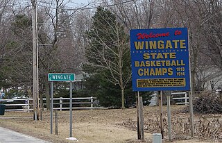
Wingate, formerly known as "Pleasant Hill", is a town in Coal Creek Township, Montgomery County, in the U.S. state of Indiana. The population was 237 at the 2020 census.

<span class="mw-page-title-main">Bluffton, Indiana</span> City in Indiana, United States

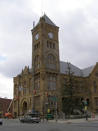
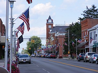
Bluffton is a city in and the county seat of Wells County, Indiana, United States. The population was 10,308 at the 2020 census, up from 9,897 at the 2010 census. Bluffton is nicknamed the "Parlor City" for its history of having some of the first clean paved streets in the area during the time of the Indiana gas boom.

<span class="mw-page-title-main">Ossian, Indiana</span> Town in Indiana, United States

Ossian is a town in Jefferson Township, Wells County, in the U.S. state of Indiana. The town was named after Ossian, the narrator of a cycle of epic poems by the Scottish poet James Macpherson. The population was 3,289 at the 2010 census.

<span class="mw-page-title-main">Bluffton, Ohio</span> Village in Ohio, United States

Bluffton, originally known as Shannon, is a village in Allen and Hancock counties in the U.S. state of Ohio. The population was 3,967 at the 2020 census. Bluffton is home to Bluffton University, a four-year educational institution affiliated with Mennonite Church USA. Bluffton is served by the Bluffton general aviation airport. Bluffton participates in the Tree City USA program.

<span class="mw-page-title-main">DeKalb County, Indiana</span> County in Indiana, United States

DeKalb County is a county in the U.S. state of Indiana. As of the 2020 United States Census, the population was 43,265. The county seat is Auburn.

<span class="mw-page-title-main">Scott County, Indiana</span> County in Indiana, United States

Scott County is a county located in the U.S. state of Indiana. As of 2020, the population was 24,384. The county seat is Scottsburg.

References

  1. 1 2 2020 Population and Housing State Data | Indiana
  2. "Find a County". National Association of Counties. Retrieved June 7, 2011.
  3. Captain William A. Wells was captured by Native Americans as a young boy and adopted by the Miami chief Little Turtle. He eventually became a scout for Gen. "Mad Anthony" Wayne. Capt. Wells was killed by Potawatomi allied with the British at the Battle of Fort Dearborn at the outbreak of the War of 1812.
  4. Tyndall, John W. (John Wilson); Lesh, O. E. (Orlo Ervin) (1918). Standard history of Adams and Wells counties, Indiana : An authentic narrative of the past, with an extended survey of modern developments in the progress of town and country. Allen County Public Library Genealogy Center. Chicago : Lewis Publishing Co.
  5. Tyndall, John W; Lesh, O E (1918). Standard History of Adams and Wells counties, Indiana. Chicago: Lewis Publishing Co. pp. 304–6.
  6. Wells County IN (Google Maps, accessed 6 August 2020)
  7. Wells County High Point, Indiana (PeakBagger.com, accessed 6 August 2020)
  8. 1 2 "Population, Housing Units, Area, and Density: 2010 - County". US Census Bureau. Archived from the original on February 12, 2020. Retrieved July 10, 2015.
  9. 1 2 "Monthly Averages for Bluffton IN". The Weather Channel. Retrieved January 27, 2011.
  10. 1 2 Indiana Code. "Title 36, Article 2, Section 3". IN.gov. Retrieved September 16, 2008.
  11. 1 2 3 4 Indiana Code. "Title 2, Article 10, Section 2" (PDF). IN.gov. Archived (PDF) from the original on December 27, 2004. Retrieved September 16, 2008.
  12. Leip, David. "Atlas of US Presidential Elections". uselectionatlas.org. Retrieved May 21, 2018.
  13. "Annual Estimates of the Resident Population for Counties: April 1, 2020 to July 1, 2023". United States Census Bureau. Retrieved April 2, 2024.
  14. "U.S. Decennial Census". United States Census Bureau. Retrieved July 10, 2014.
  15. "Historical Census Browser". University of Virginia Library. Retrieved July 10, 2014.
  16. "Population of Counties by Decennial Census: 1900 to 1990". US Census Bureau. Retrieved July 10, 2014.
  17. "Census 2000 PHC-T-4. Ranking Tables for Counties: 1990 and 2000" (PDF). United States Census Bureau. Archived (PDF) from the original on March 27, 2010. Retrieved July 10, 2014.
  18. 1 2 "Wells County QuickFacts". US Census Bureau. Archived from the original on June 7, 2011. Retrieved September 25, 2011.
  19. "QuickFacts. Wells County IN". US Census Bureau. Retrieved July 26, 2019.
  20. 1 2 3 "Profile of General Population and Housing Characteristics: 2010 Demographic Profile Data". US Census Bureau. Archived from the original on February 13, 2020. Retrieved July 10, 2015.
  21. "Selected Social Characteristics in the US – 2006-2010 American Community Survey 5-Year Estimates". US Census Bureau. Archived from the original on February 14, 2020. Retrieved July 10, 2015.
  22. "American FactFinder - Results". factfinder.census.gov. Archived from the original on February 14, 2020. Retrieved February 3, 2022.
  23. "2020 CENSUS - SCHOOL DISTRICT REFERENCE MAP: Wells County, IN" (PDF). U.S. Census Bureau. Archived (PDF) from the original on July 23, 2022. Retrieved July 23, 2022. - Text list

40°44′N85°13′W / 40.73°N 85.22°W / 40.73; -85.22