Southern Indiana

Last updated
Southern Indiana
Southern Indiana.PNG
Coordinates: 39°0′N86°0′W / 39.000°N 86.000°W / 39.000; -86.000
Population
 (2020)
  Total1,386,568
Time zones Central
Eastern
Area code 812/930

Southern Indiana is a geographic and cultural region that generally comprises the southern third of the U.S. state of Indiana and borders the states of Illinois to the west, Kentucky to the south, and Ohio to the east. Spanning the state's southernmost 33 counties, its main population centers include Southwestern Indiana (anchored by the city of Evansville), the Louisville metropolitan area (south), and the Cincinnati metropolitan area (southeast). The region's history and geography have led to a blending of Northern and Southern cultures, distinct from the rest of the state. It is often considered to be part of the Upland South and lower Midwest. [1]

Contents

The Wabash and Ohio rivers form the region's western and southern boundaries, respectively. Elevation ranges from around 360 feet (110 m) above mean sea level at the rivers' confluence to 1,060 feet (320 m) at the highest point in the Knobstone Escarpment. Southern Indiana's topography is considerably more varied than Central and Northern Indiana, including large tracts of forest, rolling hills, and karst caves. The region is also home to the oldest exposed Devonian fossil beds in the world at the Falls of the Ohio National Wildlife Conservation Area. Situated in the Wabash Valley Seismic Zone, Southwestern Indiana is at elevated risk for earthquakes.

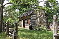
Southern Indiana, home to about 1.4 million people, was the first area of the state to be settled by European colonists. Founded in 1732, Vincennes is the oldest continually inhabited European settlement in Indiana and served as the first capital of the Indiana Territory; Corydon would later serve as the state's first capital. Protected areas include Charles C. Deam Wilderness Area, George Rogers Clark National Historical Park, Hoosier National Forest, and the Lincoln Boyhood National Memorial. Southern Indiana is home to about a dozen higher education institutions, including Indiana University Bloomington, the flagship campus of the Indiana University system. The Catholic Church has a significant presence in the region, including Saint Meinrad Archabbey, the Monastery Immaculate Conception, and Mount Saint Francis. The region is split between the Eastern and Central time zones. [2]

Geography

Sub-regions

Kentuckiana

Kentuckiana, a portmanteau of "Kentucky" and "Indiana", is a loosely defined sub-region that spans north-central Kentucky and Southern Indiana's south-central counties. It is primarily centered on the Louisville metropolitan area. Counties typically considered part of the Kentuckiana sub-region include:

Southwestern Indiana

Southeastern Indiana

Other counties

Time zones

Southwestern Indiana observes Central Time, including Posey, Vanderburgh, Warrick, Spencer, and Gibson counties. The rest of Southern Indiana observes Eastern Time.

Dialect

Southern Indiana also differs from the rest of the state linguistically. Southern dialect and South Midland dialect of American English are prevalent, as opposed to the Inland North dialect in far Northern Indiana and the North Midland dialect in Central and North-Central Indiana. Southern Indiana is the northernmost extent of the South Midland region, forming what linguists refer to as the "Hoosier Apex" of the South Midland dialect.

Educational institutions

Southern Indiana is home to IU Bloomington, the flagship campus of the Indiana University system, recognized for its academics and Indiana Hoosiers athletic program. Indiana University Bloomington - panoramio (8).jpg
Southern Indiana is home to IU Bloomington, the flagship campus of the Indiana University system, recognized for its academics and Indiana Hoosiers athletic program.

About 12 accredited institutions of higher education are located throughout Southern Indiana, including some private, liberal arts colleges and multiple public university campuses, including the flagship campus of the Indiana University system, IU Bloomington. The "‡" symbol indicates universities with main campuses outside Southern Indiana.

Public

Private

Sports

Professional sports

There are two professional sports teams in the region, both located in Evansville – the Evansville Thunderbolts (founded in 2018), and the Evansville Otters (founded in 1995) play in baseball's independent Frontier League.

College sports

National Collegiate Athletic Association Division I
National Collegiate Athletic Association Division II
National Collegiate Athletic Association Division III
National Association of Intercollegiate Athletics (NAIA)
National Junior College Athletic Association (NJCAA)

See also

Related Research Articles

<span class="mw-page-title-main">Warrick County, Indiana</span> County in Indiana, United States

Warrick County is a county located in the U.S. state of Indiana. As of 2020, the population was 63,898. The county seat is Boonville. It was organized in 1813 and was named for Captain Jacob Warrick, an Indiana militia company commander killed in the Battle of Tippecanoe in 1811. It is one of the ten fastest-growing counties in Indiana.

<span class="mw-page-title-main">Gibson County, Indiana</span> County in Indiana, United States

Gibson County is a county in the southwestern part of the U.S. state of Indiana. As of the 2020 United States Census, the population was 33,011. The county seat is Princeton.

<span class="mw-page-title-main">Scouting in Indiana</span>

Scouting in Indiana has a long history, from the 1910s to the present day, serving thousands of youth in programs that suit the environment in which they live.

<span class="mw-page-title-main">Evansville, Indiana</span> City in Indiana, United States

Evansville is a city in and the county seat of Vanderburgh County, Indiana, United States. With a population of 118,414 at the 2020 census, it is Indiana's third-most populous city after Indianapolis and Fort Wayne, the most populous city in Southern Indiana, and the 249th-most populous city in the United States. It is the central city of the Evansville metropolitan area, a hub of commercial, medical, and cultural activity of southwestern Indiana and the Illinois–Indiana–Kentucky tri-state area, which is home to over 911,000 people. The 38th parallel north crosses the north side of the city and is marked on Interstate 69 immediately north of its junction with Indiana 62 within the city's east side.

<span class="mw-page-title-main">Kentuckiana</span> Place in the United States

Kentuckiana, a portmanteau of Kentucky and Indiana, is the area in the Upland South region of the United States containing metropolitan areas with counties in both Kentucky and Indiana. Kentuckiana is primarily the Louisville metropolitan area, including nine counties in Kentucky and five counties in Southern Indiana. This area "is regularly referred to as Kentuckiana".

<span class="mw-page-title-main">Area codes 812 and 930</span> Area codes that serve the southern third of the state of Indiana

Area codes 812 and 930 are telephone area codes in the North American Numbering Plan (NANP) for the southern third of the state of Indiana.

<span class="mw-page-title-main">Indiana's 8th congressional district</span> U.S. House district for Indiana

Indiana's 8th congressional district is a congressional district in the U.S. state of Indiana. Based in southwest and west central Indiana, the district is anchored in Evansville and also includes Jasper, Princeton, Terre Haute, Vincennes, and Washington.

<span class="mw-page-title-main">Geography of Indiana</span> Overview of the geography of Indiana

The geography of Indiana comprises the physical features of the land and relative location of U.S. State of Indiana. Indiana is in the north-central United States and borders on Lake Michigan. Surrounding states are Michigan to the north and northeast, Illinois to the west, Kentucky to the south, and Ohio to the east. The entire southern boundary is the Ohio River.

<span class="mw-page-title-main">South Gibson School Corporation</span> School district in Indiana

The South Gibson School Corporation is the largest of the three public school governing institutions in both enrollment and territory covered in Gibson County, Indiana as well as one of the ten largest in enrollment in Southwestern Indiana. The SGSC is responsible for a district including four townships of southern and southwestern Gibson County; Johnson, Montgomery, Union, Wabash, and parts of Barton, Center and Patoka Townships within Gibson County as well as drawing in students from Northern Vanderburgh and Posey Counties. It consists of a superintendent, a five-member school board, eight principals and vice principals and employs around 190 teachers and specialists. The SGSC's renovation of the then-35-year-old Gibson Southern High School was complete as of 2010-11 School Year.

<span class="mw-page-title-main">Southwestern Indiana</span> Region in Indiana, United States

Southwestern Indiana is an 11-county region of southern Indiana, United States located at the southernmost and westernmost part of the state. As of the 2010 census, the region's combined population is 474,251. Evansville, Indiana's third-largest city, is the primary hub for the region, as well as the primary regional hub for a tri-state area that includes Kentucky and Illinois. Other regional hubs include Jasper, Vincennes, and Washington. Although part of a Midwestern state, this region's culture and language, like much of the rest of Southern Indiana, is aligned more with that of the Upland South rather than the Midwest.

<span class="mw-page-title-main">Vincennes Trace</span> Trackway

The Vincennes Trace was a major trackway running through what are now the American states of Kentucky, Indiana, and Illinois. Originally formed by millions of migrating bison, the Trace crossed the Ohio River near the Falls of the Ohio and continued northwest to the Wabash River, near present-day Vincennes, before it crossed to what became known as Illinois. This buffalo migration route, often 12 to 20 feet wide in places, was well known and used by American Indians. Later European traders and American settlers learned of it, and many used it as an early land route to travel west into Indiana and Illinois. It is considered the most important of the traces to the Illinois country.

<span class="mw-page-title-main">Interstate 64 in Indiana</span> Section of Interstate Highway in Indiana

Interstate 64 (I-64) in the US state of Indiana is a major east–west highway providing access between Illinois and Kentucky. It passes through southern Indiana as part of its connection between the two metropolitan areas of St Louis, Missouri, and Louisville, Kentucky.

<span class="mw-page-title-main">Southern Indiana Career & Technical Center</span> Vocational & trade magnet high school in Evansville, Indiana, USA

The Southern Indiana Career & Technical Center is a high school-level institution that provides advanced education to meet the demand in the areas of agriculture, business and marketing, family and consumer sciences, health careers, and trade and industry arts to the students in Indiana's Area Career & Technical District #46 (ACTD-46) consisting of nine school district and corporations in Gibson, Posey, Spencer, Vanderburgh and Warrick Counties in Southwestern Indiana. 90.7 FM WPSR, which used to broadcast from Central High School, now broadcasts from the center.

The Evansville metropolitan area is the 164th largest metropolitan statistical area (MSA) in the United States. The primary city is Evansville, Indiana, the third most populous city in Indiana and the most populous city in Southern Indiana as well as the hub for Southwestern Indiana. Other Indiana cities include Boonville, Mount Vernon, Jasper, Oakland City, Princeton, and Vincennes. Large towns in Indiana include Chandler, Fort Branch, McCutchanville, and Newburgh. Cities in Kentucky include Henderson, Dixon, Providence, and Robards and currently covers an area of 2,367 sq mi (6,130 km2). It is the primary metropolitan area in the Illinois–Indiana–Kentucky Tri-State Area.

<span class="mw-page-title-main">Underground Railroad in Indiana</span>

The Underground Railroad in Indiana was part of a larger, unofficial, and loosely-connected network of groups and individuals who aided and facilitated the escape of runaway slaves from the southern United States. The network in Indiana gradually evolved in the 1830s and 1840s, reached its peak during the 1850s, and continued until slavery was abolished throughout the United States at the end of the American Civil War in 1865. It is not known how many fugitive slaves escaped through Indiana on their journey to Michigan and Canada. An unknown number of Indiana's abolitionists, anti-slavery advocates, and people of color, as well as Quakers and other religious groups illegally operated stations along the network. Some of the network's operatives have been identified, including Levi Coffin, the best-known of Indiana's Underground Railroad leaders. In addition to shelter, network agents provided food, guidance, and, in some cases, transportation to aid the runaways.

<span class="mw-page-title-main">Indiana</span> U.S. state

Indiana is a state in the Midwestern region of the United States. It borders Lake Michigan to the northwest, Michigan to the north and northeast, Ohio to the east, the Ohio River and Kentucky to the south and southeast, and the Wabash River and Illinois to the west. It is the 38th-largest by area and the 17th-most populous of the 50 States. Its capital and largest city is Indianapolis. Indiana was admitted to the United States as the 19th state on December 11, 1816.

<span class="mw-page-title-main">Indiana High School Athletic Association</span>

The Indiana High School Athletic Association (IHSAA) is the arbiter of interscholastic competition among public and private high schools in the U.S. state of Indiana.

<span class="mw-page-title-main">Illinois–Indiana–Kentucky tri-state area</span> Tri-state region of the United States

The Illinois–Indiana–Kentucky tri-state area is a tri-state area where the U.S. states of Illinois, Indiana, and Kentucky intersect. The area is defined mainly by the television viewing area and consists of ten Illinois counties, eleven Indiana counties, and nine Kentucky counties, centered upon the Ohio and Wabash Rivers.

<span class="mw-page-title-main">Kasson, Indiana</span> Unincorporated community in Indiana, United States

Kasson is an unincorporated community in German Township, Vanderburgh County, in the U.S. state of Indiana.

References

  1. Madison, James H. (August 28, 2014). The Story of Us. Indianapolis Monthly. Retrieved February 18, 2021.
  2. Mack, Justin L. (March 8, 2019). "Looking back at Indiana's complicated relationship with time: Why Indiana observes daylight saving time". The Indianapolis Star. Retrieved January 26, 2024.