Related Research Articles

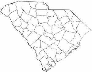
Georgetown County is a county located in the U.S. state of South Carolina. As of the 2010 census, the population was 60,158. Its county seat is Georgetown. The county was founded in 1769. It is named for George III of the United Kingdom.

Berkeley County is a county in the U.S. state of South Carolina. As of the 2010 census, its population was 177,843. Its county seat is Moncks Corner. After two previous incarnations of Berkeley County, the current county was created in 1882.
Jamestown is a town in Berkeley County, South Carolina, United States. The population was 72 at the 2010 census.

Georgetown is the third oldest city in the U.S. state of South Carolina and the county seat of Georgetown County, in the Lowcountry. As of the 2010 census it had a population of 9,163. Located on Winyah Bay at the confluence of the Black, Great Pee Dee, Waccamaw, and Sampit rivers, Georgetown is the second largest seaport in South Carolina, handling over 960,000 tons of materials a year.

The Province of North Carolina was a British colony that existed in North America from 1712 to 1776, created as a proprietary colony. The power of the British government was vested in a governor of North Carolina, but the colony declared independence from Great Britain in 1776. The Province of North Carolina had four capitals: Bath (1712–1722), Edenton (1722–1743), Brunswick (1743–1770), and New Bern. The colony later became the states of North Carolina and Tennessee, and parts of the colony combined with other territory to form the states of Georgia, Alabama, and Mississippi.
The Province of Carolina was an English and later a British colony of North America. Carolina was founded in what is present-day North Carolina. Carolina expanded south and, at its greatest extent, nominally included the present-day states of North Carolina, South Carolina, Georgia, Alabama, Tennessee and Mississippi, and parts of modern Florida and Louisiana.

The Waccamaw River is a river, approximately 140 miles (225 km) long, in southeastern North Carolina and eastern South Carolina in the United States. It drains an area of approximately 1,110 square miles (2886 km²) in the coastal plain along the eastern border between the two states into the Atlantic Ocean. Along its upper course, it is a slow-moving, blackwater river surrounded by vast wetlands, passable only by shallow-draft watercraft such as canoe. Along its lower course, it is lined by sandy banks and old plantation houses, providing an important navigation channel with a unique geography, flowing roughly parallel to the coast.
The Pee Dee is a region of South Carolina located in the northeastern corner of the state. It lies along the lower watershed of the Pee Dee River, which was named after the Pee Dee Indian Tribe, a state-recognized tribe of approximately 200 members.
A lord proprietor is a person granted a royal charter for the establishment and government of an English colony in the 17th century. The plural of the term is "lords proprietors" or "lords proprietary".

The history of the colonial period of South Carolina focuses on the English colonization that created one of the original Thirteen Colonies. Major settlement began after 1651 as the northern half of the British colony of Carolina attracted frontiersmen from Pennsylvania and Virginia, while the southern parts were populated by wealthy English people who set up large plantations dependent on slave labor, for the cultivation of cotton, rice, and indigo.
This article discusses the early history of Williamsburg County, South Carolina
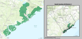
The 1st Congressional District of South Carolina is a coastal congressional district in South Carolina, represented by Democrat Joe Cunningham since January 3, 2019. He succeeded Republican Mark Sanford, who was defeated by Katie Arrington in the Republican primary. Cunningham is the first Democrat to represent the district since the 1980s.
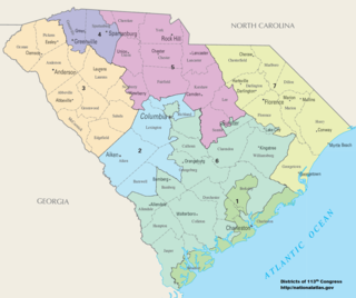
There are currently seven United States congressional districts in South Carolina. There have been as few as four and as many as nine congressional districts in South Carolina. The 9th district and the 8th district were lost after the 1840 Census. Because the state exceeded the nation's average population growth in the 2010 Census, South Carolina regained its 7th district, which had remained unused since the Civil War.

St. James Church, Santee, also known as St. James Episcopal Church, Santee, is a historic church located in a remote portion of Francis Marion National Forest in Charleston County, South Carolina. Built in 1768, it is a remarkably sophisticated expression of fashionable Georgian architecture in a remote area, and was designated a National Historic Landmark in 1970 for its architectural significance. It is located on the west side of the Old Georgetown Road, several miles north of South Carolina Highway 46 and McClellanville.
Henry Mouzon II was a colonial era patriot and renowned civil engineer. He prepared the definitive survey of the North and South Carolina Colonies prior to the start of the American Revolutionary War. He served as an Officer of the Continental Line and as a Militia Officer in Francis Marion’s Brigade, where he distinguished himself in the Battle of Black Mingo.

Prince George Winyah Church is an Anglican church in Georgetown, South Carolina. Prince George Winyah is one of the oldest continuous congregations in South Carolina, and the church building is one of the oldest churches in continuous service in South Carolina. Prince George Winyah (Anglican) and Churchyard was named to the National Register of Historic Places on May 6, 1971.

Temple Beth Elohim is a Reform synagogue located at 230 Screven Street in Georgetown, South Carolina.

Battery White was an artillery battery constructed by the Confederates during the American Civil War. Built in 1862–63 to defend Winyah Bay on the South Carolina coast, the battery was strongly situated and constructed; however, it was inadequately manned, and was captured without resistance during the final months of the war.
References
- 1 2 3 4 5 6 7 8 9 South Carolina Department of Archives and History. "The Formation of Counties in South Carolina". South Carolina Department of Archives and History. Archived from the original on 21 July 2011. Retrieved 29 April 2020.
- ↑ Frederick A. Porcher: "Historical and Social Sketch of Craven County, So. Ca." in The Southern Quarterly Review, April, 1852; reprinted in Thomas T. Gaillard: A Contribution to the History of the Huguenots of South Carolina, New York, 1887. New York: Knickerbocker Press, 1887. 52 pp.
- ↑ Anne Baker, Leland Bridges, and Roy Williams III: St. James Santee, Plantation Parish, History and Records, 1685-1925, Spartanburg, S.C.: The Reprint Company, Publishers, 1997.
- ↑ Thomas Cooper: The Statutes at Large of South Carolina', Volume 4, Containing the Acts from 1752, Exclusive, to 1786, Inclusive. Columbia, S.C.: A. S. Johnston, 1838. Vol. 4, pp. 662-663.