
The Pahranagat Valley is a Tonopah Basin landform in Lincoln County, Nevada.

Ash Springs is an unincorporated community in the Pahranagat Valley of Lincoln County, Nevada. The community's principal industry is ranching. Ash Springs is named for the desert ash trees growing nearby.
Warm Springs is a former town in the Tonopah Basin in Nye County, Nevada, near the mountain pass which divides the Kawich and Hot Creek ranges. It is located at the junction of U.S. Route 6 and State Route 375, around 50 miles east of Tonopah. Only two abandoned buildings remain.

Hiko is a small, agrarian community in the Tonopah Basin on State Route 318 in Lincoln County, Nevada, United States. It is a census-designated place, with a population of 119 at the 2010 census.

U.S. Route 50 (US 50) is a transcontinental highway in the United States, stretching from West Sacramento, California, in the west to Ocean City, Maryland, on the east coast. The Nevada portion crosses the center of the state and was named "The Loneliest Road in America" by Life magazine in July 1986. The name was intended as a pejorative, but Nevada officials seized it as a marketing slogan. The name originates from large desolate areas traversed by the route, with few or no signs of civilization. The highway crosses several large desert valleys separated by numerous mountain ranges towering over the valley floors, in what is known as the Basin and Range province of the Great Basin.

Galena is an abandoned town in Washoe County, Nevada, south of Reno. The portion of Reno just south of Mount Rose Highway and west of Steamboat Springs is also known as Galena.
Belleville, Nevada, in Mineral County, Nevada, United States, was a mining town that rose up around the milling of ore shipped in from nearby mines. Today it is a ghost town.

Logan, Nevada, is a ghost town located in the hills about 9.5 mi (15.3 km) west of Hiko and 2.5 mi (4.0 km) south of Mount Irish Peak. Logan had its brief existence as a mining camp when silver ore was discovered in 1865 in the Mount Irish Range just to the north in Silver Canyon on the east flank of Mount Irish.
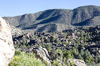
The Mount Irish Range is a mountain range in Lincoln County, Nevada. The range is bounded by the Coal Valley to the north, the Pahranagat Valley to the east, the Tikaboo Valley to the southwest and the Wild Horse Valley to the northwest. Surrounding ranges include the Seaman Range and Hiko Range to the east, the Pahranagat Range and East Pahranagat Range to the south and south east, the Groom Range to the southwest, the Timpahute Range to the west and the Golden Gate Range across Murphy Gap to the northwest.
Potts is a ghost town and abandoned ranching property in Monitor Valley, Nye County, Nevada, approximately 2 miles east of Nevada State Route 82.

Sunnyside is a small unincorporated community in the White River Valley of eastern Nevada, near the southern terminus of the Egan Range. The site is located on State Route 318 approximately 31 miles by road south of Lund in White Pine County, the closest town, and 63 miles by road north of Hiko in Lincoln County.
Schellbourne, formerly known as Fort Schellbourne and Schell Creek Station is a ghost town located in the Schell Creek Range in White Pine County in Nevada, United States, located 43 miles (69 km) north of Ely. The town was a stopover along the Central Overland Route, Pony Express and original routing of the Lincoln Highway. It is today Nevada Historical Marker number 51. The site was listed on the National Register of Historic Places in 1972. Its boundaries were increased in 1977.

Fairview is a ghost town in Churchill County, Nevada, in the United States of America.
Potosi or Potosi Camp, was called Crystal City in the 1870s, a mining ghost town in Clark County, Nevada. It lies at an elevation of 5705 feet.
White Plains is a ghost town in Churchill County, in the U.S. state of Nevada.
Alkali is a ghost town located in Esmeralda County, Nevada. Alkali is the site of Alkali Hot Spring, which was operated as a spa by Geni and Joe Guisti in the 1930s. During Goldfield's peak, the site included an indoor wooden swimming pool with a separate area for children and a large building containing a dining room, kitchen, dance hall and bar. In front of the dining room were tall tamarisk trees and a large picnic table where visitors could either order from the dining room or bring their own lunches. The Guisti residence was at the rear of the dining room. Geni Guisti served young folks grape juice over ice at the bar, which was considered a real treat. Friday and Saturday night dances were attended by Tonopah residents.

Bullionville is a ghost town in Lincoln County, Nevada, United States, 1/4 mile east of U.S. Route 93, one mile north of Panaca and 10 miles (16 km) south of Pioche. The town prospered between 1870 and 1882, and is now abandoned.
Tempiute is a ghost town in Lincoln County, Nevada United States.

Crystal Springs hot springs is a system of geothermal springs and seeps near Ash Springs, located at the site of a ghost town, Crystal Springs, Nevada. Several marshes and springs are located along the White River.


