Culbin Sands, Forest and Findhorn Bay is a huge area of coast and countryside and an SSSI (site of special scientific interest) in Moray, Scotland, stretching from just east of the town of Nairn eastwards to the village of Findhorn and its bay. All of the areas are very important for wildlife in general and are strongly protected by law. The Culbin Sands are known in Gaelic as Bar Inbhir Èireann.
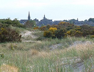
The eastern end of the Culbin Forest from the north west with the Moray Firth in the foreground and Burghead Bay and Findhorn Bay beyond
This huge forest is almost completely owned by the Forestry and Land Scotland.[1] It is split by several large paths and smaller tracks in between. The densely covered areas off these paths are difficult to traverse. Most walks are taken beginning at the south of the forest at Wellhill Car Park and ending at the beach. Among the trees there are several strange monoliths bearing messages, and at one tree there is a small plaque commemorating its planting by Prince Charles. Although mostly made up of tall pines and coarse ground cover, Culbin also has many more open, sandy patches in the forest, where small younger trees have recently been planted. The grassland areas are very suitable for butterflies. There are several ponds which act as oases to the local animals. Hill 99, a towering wooden structure which blends in subtly with the canopy, provides an excellent viewpoint. The wildlife amongst the trees is very discreet although birds can clearly be heard singing everywhere.
The forest hosts breeding crested tits.[2] The forest is also an important site for the Kentish glory moth (Endromis versicolora),[3] which exploits the forestry activity carried out by Forestry and Land Scotland. The timber felling generates spaces for birch saplings to take root, the larval food plant of the moths, which prefer saplings under three metres tall. The moths follow the timber felling around the forest, and the adults can be seen in April and May.
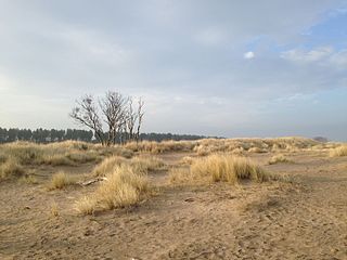
Culbin Sands
Nowadays the name "Culbin Sands" means a beach, but formerly the name meant a large area of loose dune sand desert which is now the Culbin Forest. In its heyday, the dune system was the largest in Britain.
This long strip of pristine beach is owned by the RSPB,[4] due to its excellent bird habitat, home to Eurasian oystercatchers, Eurasian curlews, common redshanks and other birds. It is made up of a curious mixture of sand and long grass, but gets muddier further westwards. Much natural driftwood ends up on the sands. Three sand spits enclose a large salt marsh known as 'The Gut'. The largest, known as 'The Bar', is the largest spit in Scotland.
Towards Nairn, the beach is home to a wintering population of pale-bellied brant geese, one of only two in Scotland.[5] The birds belong to the Svalbard population.
In 1888 and 1889, the dunes hosted breeding pairs of Pallas's sandgrouse, the only time this has ever been recorded in Scotland.[6]
The sands had a reputation for shifting, engulfing homesteads. This was due to removal of marram from the dunes for thatching, as the roots helped to hold the soil together. The Forestry Commission (now Forestry and Land Scotland) sought to stabilise the dune in much a similar method by planting scrub, before giving the land over to forestry.
Findhorn Bay
Aerial photo of Findhorn Bay, with the east end of the Culbin Forest at right and the estuary of the River Findhorn at centre.
The 'Bay' is not a true bay at all, but a large tidal basin. It is enclosed by the villages of Kinloss and Findhorn to the east, and Culbin Forest to the west. It drains the river Findhorn and the Muckle Burn.
In the winter, the bay is home to a roost of at least 10,000 pink-footed geese.[7] The flock is exploited by fowlers, leading to some tensions locally with animal lovers.
The bay is deepest in the channel leading out to the Moray Firth, reaching up to 10 metres. Other than that, the bay is predominantly shallow, the average depth being circa 2 metres. Due this safety, and lack of strong swell, the bay is popular with amateur sailors and windsurfers.
History
There was a village situated to the North East of the Culbin Forest, although the exact location is not known. Reports of the village and land around it being buried in sandstorms of 1694,[8] as reported by several major channels, was not captured in the news records of the time. Stories of the village being buried by sandstorm are based in folklore. However, recordings of this time (still stored by the Local Heritage Centre in Elgin, Moray) mention the town and its deforestation of the Culbin Forest, which resulted in destabilizing the land between the village and the mainland. This allowed the sea to corrode the land and, eventually, sink the town.
This was the same scenario also impacted the village Findhorn, which used to extend further north into the Sea.
Due to the extent of the Culbin deforestation by the Village of Culbin, the Culbin Sands sat empty until the 1920s when the Forestry Commission planted the area with pine trees over a period of 40 years.[8][9][10][11][12][13]
Holkham National Nature Reserve is England's largest national nature reserve (NNR). It is on the Norfolk coast between Burnham Overy Staithe and Blakeney, and is managed by Natural England with the cooperation of the Holkham Estate. Its 3,900 hectares comprise a wide range of habitats, including grazing marsh, woodland, salt marsh, sand dunes and foreshore. The reserve is part of the North Norfolk Coast Site of Special Scientific Interest, and the larger area is additionally protected through Natura 2000, Special Protection Area (SPA) and Ramsar listings, and is part of both an Area of Outstanding Natural Beauty (AONB) and a World Biosphere Reserve. Holkham NNR is important for its wintering wildfowl, especially pink-footed geese, Eurasian wigeon and brant geese, but it also has breeding waders, and attracts many migrating birds in autumn. A number of scarce invertebrates and plants can be found in the dunes, and the reserve is one of the only two sites in the UK to have an antlion colony.
The Firth of Forth is the estuary, or firth, of several Scottish rivers including the River Forth. It meets the North Sea with Fife on the north coast and Lothian on the south.
Nairn is a town and royal burgh in the Highland council area of Scotland. It is an ancient fishing port and market town around 17 miles (27 km) east of Inverness, at the point where the River Nairn enters the Moray Firth. It is the traditional county town of Nairnshire.
The Forvie National Nature Reserve is a national nature reserve owned and managed by NatureScot. It is located north of Newburgh in Aberdeenshire, in the northeast of Scotland. The reserve includes the Sands of Forvie, which are the fifth largest sand dune system in Britain, and the least disturbed by human activity. The dune system is an integral part of the Ythan Estuary, which also forms part of the reserve, and separates the sands from Balmedie beach.
The Oregon Dunes National Recreation Area is located on the Oregon Coast, stretching approximately 40 miles (64 km) north of the Coos River in North Bend to the Siuslaw River in Florence, and adjoining Honeyman State Park on the west. It is part of Siuslaw National Forest and is administered by the United States Forest Service.
Findhorn is a village in Moray, Scotland. It is located on the eastern shore of Findhorn Bay and immediately south of the Moray Firth. Findhorn is 3 miles (5 km) northwest of Kinloss, and about 5 miles (9 km) by road from Forres.
Aberlady is a coastal village in the Scottish council area of East Lothian. The village had an estimated population of 1,260 in 2020.
Gullane is a town on the southern shore of the Firth of Forth in East Lothian on the east coast of Scotland. There has been a church in the village since the ninth century. The ruins of the Old Church of St. Andrew built in the twelfth century can still be seen at the western entrance to the village; the church was abandoned after a series of sandstorms made it unusable, and Dirleton Parish Church took its place.
Newborough Warren near the village of Newborough (Niwbwrch) is a large dune and beach system of 2,269 hectares, approximately half of which is a conifer plantation. The whole area is designated as a Site of Special Scientific Interest and all of the site except the forestry is a national nature reserve.
The Ythan Estuary is the tidal component of the Ythan River, emptying into the North Sea 19 kilometres (12 mi) north of Aberdeen, Scotland. The estuary’s tidal action extends a 7 kilometres (4.3 mi) inland and has characteristic widths of between 250 metres (820 ft) and 780 metres (2,560 ft). Besides the tidal channel there are interfaces to the upland dunes including mudflats, sand beaches and shingle flats. Reaches of salt marsh occur, but they are primarily near the Waterside Bridge and the mouth of the Tarty Burn, a small tributary river. Based upon the habitat of the moorland bordering the east of the Ythan River near the mouth, this estuary is the most significant coastal moorland in the northern United Kingdom.
The River Findhorn is one of the longest rivers in Scotland. Located in the north east, it flows into the Moray Firth on the north coast. It has one of the largest non-firth estuaries in Scotland.
The John Muir Country Park is a country park near the village of West Barns, which is part of the town of Dunbar in East Lothian, Scotland. It is named after John Muir, a famous naturalist and geologist who was born in Dunbar and later emigrated to the United States, where he developed his ideas.
The Streckelsberg is an approximately 58-metre high coastal cliff on the island of Usedom in North Germany. After the Golm and the Kückelsberg, the Streckelsberg is the third highest elevation on the island. The Streckelsberg is located half a kilometre southeast of the former fishing village and present-day seaside resort of Koserow directly on the Baltic Sea shore. To the southeast is the village of Kölpinsee; the B 111 federal road and Usedomer Bäderbahn railway run past the hill to the southwest.
Tentsmuir National Nature Reserve (NNR) is located southeast of Tayport in Fife, Scotland. The reserve is made up of three parts, encompassing Morton Lochs, Tentsmuir Point and Tayport Heath, and is managed by NatureScot. The different sections of Tentsmuir NNR were originally designated as separate national nature reserves at different times: the Morton Lochs section was designated in 1952; Tentsmuir Point in 1954; and Tayport Heath in 1988. While these discrete sections are distant from one another, they form part of the extensive dune system at Tentsmuir, and in 2003 SNH combined the three sites to form Tentsmuir National Nature Reserve. The adjoining Tentsmuir Forest is managed by Forestry and Land Scotland and covers most of the land between the three portions of the NNR.
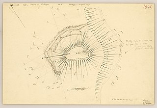
The Doune of Relugas is a hill fort located 9.25 kilometres (5.75 mi) south south west of Forres in Moray, Scotland. It is situated on a rocky knoll rising to approximately 400 feet (120 m) above ordnance datum and forming the south east part of the promontory at the confluence of the River Findhorn and the River Divie. The site commands an uninterrupted view of the valley of the Findhorn as far as Culbin Sands, 9 miles to the north on the shore of the Moray Firth.
The Moray and Nairn Coast is a protected wetland site on the southern shore of the Moray Firth, in the west of Scotland. A total of 2,412 hectares comprises two areas: intertidal flats, saltmarsh and sand dunes at Findhorn Bay and Culbin Bar, and alluvial deposits and woodland of the lower River Spey and Spey Bay. It has been protected as a Ramsar Site since 1997.
Culbin House was a manor house, in the Culbin Sands, near Forres, Moray in Scotland. The house was the caput of the feudal barony of Culbin.
This page is based on this Wikipedia article Text is available under the CC BY-SA 4.0 license; additional terms may apply. Images, videos and audio are available under their respective licenses.