Cumbre Vieja tsunami hazard

Last updated

Cumbre Vieja tsunami hazard
Location of Cumbre Vieja in the North Atlantic Ocean.
The island of La Palma in the Atlantic Ocean (Isla de la Palma) La Palma & La Gomera Islands, Canary Islands (cropped).jpg
The island of La Palma in the Atlantic Ocean

The island of La Palma in the Canary Islands is at risk of undergoing a large landslide, which could cause a tsunami in the Atlantic Ocean. Volcanic islands and volcanoes on land frequently undergo large landslides/collapses, which have been documented in Hawaii for example. A recent example is Anak Krakatau, which collapsed to cause the 2018 Sunda Strait tsunami.

Contents

Steven N. Ward and Simon Day in a 2001 research article proposed that a Holocene change in the eruptive activity of Cumbre Vieja volcano and a fracture on the volcano that formed during an eruption in 1949 may be the prelude to a giant collapse. They estimated that such a collapse could cause tsunamis across the entire North Atlantic and severely impact areas as far away as North America. Later research has debated whether the tsunami would still have a significant size far away from La Palma, as the tsunami wave may quickly decay in height away from the source and interactions with the continental shelves could further reduce its size. Evidence indicates that most collapses in the Canary Islands took place as multistage events that are not as effective at creating tsunamis, and a multi-stage collapse at La Palma likewise would result in smaller tsunamis.

The recurrence rate of similar collapses is extremely low, about one every 100,000 years or less in the case of the Canary Islands. Other volcanoes across the world are at risk of causing such tsunamis.

Sector collapses and tsunamis caused by them

Giant landslides and collapses of ocean island volcanoes were first described in 1964 in Hawaii and are now known to happen in almost every ocean basin. [1] As volcanoes grow in size they eventually become unstable and collapse, generating landslides [2] and collapses such as the failure of Mount St. Helens in 1980 [3] and many others. [4] In the Hawaiian Islands, collapses with volumes of over 5,000 cubic kilometres (1,200 cu mi) have been identified. [5]

A number of such landslides have been identified in the Canary Islands, especially in the more active volcanoes El Hierro, La Palma and Tenerife [6] where about 14 such events are recorded through their deposits. [7] They mostly take the form of debris flows [6] with volumes of 50–200 cubic kilometres (12–48 cu mi) [7] that emanate from an amphitheatre-shaped depression on the volcanic island and come to rest on the seafloor at 3,000–4,000 metres (9,800–13,100 ft) depth. They do not appear to form through individual collapses; multi-stage failures lasting hours or days appear to be more common [6] as has been inferred from the patterns of landslide-generated turbidite deposits in the Agadir Basin north of the Canary Islands. [8] The most recent such event took place at El Hierro 15,000 years ago [6] and was later re-dated to have occurred between 87,000±8,000 (margin of uncertainty) and 39,000±13,000 years ago. [9]

Many processes are involved in the onset of volcano instability and the eventual failure of the edifice. [10] Mechanisms that destabilize volcanic edifices to the point of collapse include inflation and deflation of magma chambers during the entry of new magma, intrusion of cryptodomes and dykes, and instability of slopes under loading from lava flows and oversteepened lava domes. Periodic collapses have been found at some volcanoes, such as at Augustine and Volcan de Colima. [11] Shield volcanoes have different mechanical properties than stratovolcanoes as well as flatter slopes and undergo larger collapses than the latter. [12] Finally, the mechanical stability both of the volcanic edifice and the underlying basement and the influence of climate and sea level changes play a role in volcano stability. [11]

Tsunami hazards

Large collapses on volcanoes have generated tsunamis, of which about 1% relates to volcanic collapse; [4] both small collapses [1] and earthquake-linked landslides that took place in historical times generated tsunamis. [13] The 1998 Papua New Guinea earthquake in particular drew attention to this hazard. [14] The most recent such tsunami is the 2018 Sunda Strait tsunami, which was caused by a flank collapse of Anak Krakatau and caused at least 437 fatalities. [15] The possibility of a large collapse of this volcano causing a tsunami was known already before the 2018 event, [16] and the disaster drew attention to the dangers associated with non-earthquake tsunamis. [17]

Other historically recorded examples include the 1929 Grand Banks earthquake, the 1958 Lituya Bay tsunami, [18] numerous tsunamis at Stromboli including a 2002 tsunami [19] that caused severe damage to coastal settlements, [5] the 1888 tsunami caused by the Ritter Island collapse [20] which killed about 3000 people [5] and is the largest historical tsunami-forming collapse with a volume of 5 cubic kilometres (1.2 cu mi), [21] and the 1792 Shimabara collapse of Unzen volcano in Japan which claimed 4,000 or 14,538 victims. [5] [2] In total, volcanically generated tsunamis are responsible for about 20% of all fatalities related to volcanic eruptions. [22]

Prehistoric landslides that caused tsunamis include the Storegga slide 8,200 years ago, a 3,000 cubic kilometres (720 cu mi) submarine landslide off Norway that generated a tsunami recorded from geological evidence in the Faroe Islands, Norway and Scotland. The landslide has been modelled as a retrogressive failure that moved at a rate of 25–30 metres per second (82–98 ft/s). [23] Another landslide-induced tsunami inundated Santiago, Cape Verde, 73,000 years ago after a collapse of the neighbouring Fogo volcano. [24] More controversial is the evidence of past landslide-induced tsunamis at Kohala [21] and Lanai in the Hawaiian Islands and at Gran Canaria in the Canary Islands, [18] and other candidate deposits of landslide-induced tsunamis have been reported from Bermuda, Eleuthera, Mauritius, Rangiroa [25] [21] and Stromboli. [26]

The size of such tsunamis depends both on the geological details of the landslide (such as its Froude number [27] ) and also on assumptions about the hydrodynamics of the model used to simulate tsunami generation, thus they have a large margin of uncertainty. Generally, landslide-induced tsunamis decay more quickly with distance than earthquake-induced tsunamis, [13] as the former, often having a dipole structure at the source, [20] tend to spread out radially and has a shorter wavelength while the latter disperses little as it propagates away perpendicularly to the source fault. [23] Testing whether a given tsunami model is correct is complicated by the rarity of giant collapses. [28] The term "megatsunami" has been defined by media and has no precise definition, although it is commonly taken to refer to tsunamis over 100 metres (330 ft) high. [29]

Regional context: Cumbre Vieja and the Atlantic Ocean

The Cumbre Vieja volcano lies on the southern third of La Palma (Canary Islands) and rises about 2 kilometres (1.2 mi) [1] above sea level and 6 kilometres (3.7 mi) above the seafloor. [30] It is the fastest growing volcano in the archipelago and thus dangerous in terms of collapses and landslides. [7] Several collapses took place since the Pliocene, followed by the growth of Cumbre Vieja during the last 125,000 years. [31] The latest eruption began on 19 September 2021 following a week of seismic activity. [32]

During the Holocene volcanic activity on Cumbre Vieja has become concentrated along a north–south axis, which may reflect an incipient detachment fault under the volcano. During the 1949 eruption a 4 kilometres (2.5 mi) long normal fault developed along the crest of Cumbre Vieja; it has been inactive since then [1] and prior eruptions did not form such faults, which do not have the appearance of graben faults. [33] Geodesy has not identified ongoing movement of the flank. [34] Unlike on Hawaii, flank movements at Canary Islands appear to occur mainly during volcanic episodes. [35]

Tsunamis are less common in the Atlantic Ocean than in the Pacific or the Indian oceans, but they have been observed e.g. after the 1755 Lisbon earthquake. Apart from fault lines, submarine volcanoes such as Kick'em Jenny and landslides are sources of tsunamis in the Atlantic. [3] Tsunamis are not unique to the sea; a landslide in the Vajont Dam in 1963 caused a megatsunami resulting in around 2000 fatalities, and evidence of past tsunamis is recorded from Lake Tahoe. [36] [37]

Models

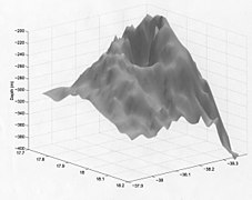
Model by Ward and Day 2001

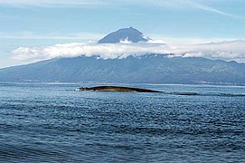
Ward and Day 2001 estimated that the unstable part of Cumbre Vieja would be at least 15 kilometres (9.3 mi) wide in north–south direction. In light of the behaviour of other documented sector collapses such as at Mount St. Helens, the headscarp of the unstable part of Cumbre Vieja is likely 2–3 kilometres (1.2–1.9 mi) east from the 1949 fault [1] and the toe of the sector lies at 1–3 kilometres (0.62–1.86 mi) depth below sea level. Bathymetric observations west of La Palma support this interpretation. They had not enough information with which to estimate the thickness of the block but assumed that it would have a volume of about 150–500 cubic kilometres (36–120 cu mi) and the shape of a wedge, comparable to the Cumbre Nueva giant landslide 566,000 years ago also on La Palma. [38]

The authors used linear wave theory to estimate the tsunami induced by the simulated Cumbre Vieja. [38] They used a scenario of a collapse of 500 cubic kilometres (120 cu mi) that moves at a rate of about 100 metres per second (330 ft/s) on top of a layer of mud or landslide breccia, which lubricate its movement, and eventually spreads 60 kilometres (37 mi) to cover a jug-shaped area of 3,500 square kilometres (1,400 sq mi). Ignoring that the landslide excavates part of the flank of Cumbre Vieja, thus assuming that it does not contribute to any tsunami generation, they estimated the following timing of the tsunami: [39]

France and the Iberian Peninsula would be affected as well. [41] Further, the authors concluded that the size of the tsunami roughly scales with the product of the landslide speed and its volume. They suggested that traces of past such tsunamis may be found in the southeastern United States, on the continental shelf, in northeast Brazil, in the Bahamas, western Africa. [40]

Later models

Mader 2001 employed a shallow water code that includes friction and the Coriolis force. Assuming shallow-water behaviour of the wave even with runup the eventual tsunami heights in the US and the Caribbean would not exceed 3 metres (9.8 ft) and in Africa and Europe it would not be higher than 10 metres (33 ft). [42] Mader 2001 also estimated that dispersion along the US coast could reduce tsunami amplitude to less than 1 metre (3 ft 3 in). [43]

Gisler, Weaver and Gittings 2006 used public domain bathymetric information [3] and the so-called "SAGE hydrocode" to simulate the tsunami [44] stemming from variously shaped landslides. The landslides generate a single wave that eventually detaches from the landslide as the latter slows down. [45] The waves have shorter wavelengths and periods than teletsunamis and thus do not spread as effectively as the latter away from the source [46] and decay away roughly with the inverse of the distance. Such tsunamis would be a greater danger to the Canary Islands, the eastern Lesser Antilles, Iberia, Morocco and northeastern South America [47] than to North America where they would be only a few centimetres high. [48]

Løvholt, Pedersen and Gisler in 2008 published another study that employed the worst-case landslide scenario of Ward and Day 2001, but used hydrodynamic modelling that accounts for dispersion, non-linear effects and the deformation of the landslide material itself to simulate waves generated by such a collapse. [7] In this model, the landslide had a volume of 375 cubic kilometres (90 cu mi) and a maximum speed of 190 metres per second (620 ft/s). It generates a high leading wave that eventually separates from the landslide, while turbulent flow behind the slide generates lower waves. Overall, a complex wave field develops [49] with a sickle-shaped front wave that is over 100 metres (330 ft) high when it reaches a radius of 100 kilometres (62 mi). [50] The waves do not decay at a constant rate with distance, with the crestal wave decaying slightly faster than 1/distance while the trailing wave decays slightly more slowly. [51] Thus at distance the trailing waves can become higher than the leading wave, [52] especially the waves propagating west display this behaviour. [53] Undulating bores also develop, a factor not commonly considered in tsunami models. [54]

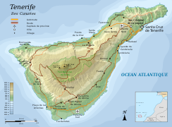
In the Løvholt, Pedersen and Gisler 2008 model, the impact in the Canary Islands would be quite severe, with the tsunami reaching heights of over 10–188 metres (33–617 ft), threatening even inland valleys and towns and hitting the two largest cities of the islands (Santa Cruz and Las Palmas) badly. [55] The impact in Florida would not be as severe as in the Ward and Day 2001 model by a factor of 2–3 [56] but wave heights of several metres would still occur around the North Atlantic. [57] Off the US coast, wave amplitude would reach 9.6 metres (31 ft). [58]

Abadie et al. 2009 simulated both the most realistic landslide geometry and the tsunamis that would result from it near its source. [59] They concluded that most realistic volumes would be 38–68 cubic kilometres (9.1–16.3 cu mi) for a small collapse and 108–130 cubic kilometres (26–31 cu mi) for a large collapse. [60] The initial height of the wave depends strongly on the viscosity of the landslide and can exceed 1.3 kilometres (0.81 mi). [61]

Løvholt, Pedersen and Glimsdal 2010 noted that landslide-generated tsunamis can have a leading wave smaller than following waves, requiring a dispersive wave model. They simulated inundation in Cadiz resulting from a 375 cubic kilometres (90 cu mi) collapse at La Palma. [62] The found runup of about 20 metres (66 ft) and the possible development of undular bores. [63]

Abadie, Harris and Grilli 2011 employed three-dimensional simulations with the hydrodynamic simulator "THETIS" to reproduce the tsunamis induced by failures of 20 cubic kilometres (4.8 cu mi), 40 cubic kilometres (9.6 cu mi), 80 cubic kilometres (19 cu mi) and 450 cubic kilometres (110 cu mi). These volumes were taken from studies on the stability of La Palma's western flank, while the 450 cubic kilometres (110 cu mi) reflects worst-case scenarios from earlier tsunami studies at Cumbre Vieja. [64] The landslide is directed southwestward and induces a wave train, with the 80 cubic kilometres (19 cu mi) collapse having a maximum wave height of 80 metres (260 ft). [65] At El Hierro the tsunami can shoal and rise to a height of 100 metres (330 ft), while the wave train surrounds La Palma and continues eastward with a height of 20–30 metres (66–98 ft). [66]

Zhou et al. 2011 used numerical simulations to model various tsunamis, including a scenario resulting from a mass failure at La Palma. [67] It assumes a smaller volume of 365 cubic kilometres (88 cu mi) as the collapse hits only the western flank [68] and does not assume a southwest-directed propagation direction, thus increasing the hazard to the US coast. [69] The resulting tsunami approaches the US coast between 6–8 hours after the collapse, in a north-to-south fashion. [70] Waves grow due to shoaling as they approach the continental shelf [71] but later decline due to increased bottom friction [72] and eventually reach heights of 3–10 metres (9.8–32.8 ft) when they come ashore. The impact of undular bore formation on runup is unclear. [72]

Abadie et al. 2012 simulated both the development of waves using dispersive models that include non-linear effects, and the behaviour of the landslide generating them through slope stability and material strength models. [73] They considered both volumes of 38–68 cubic kilometres (9.1–16.3 cu mi), obtained from research on the stability of the flank of Cumbre Vieja, as well as volumes of 500 cubic kilometres (120 cu mi) as hypothesized by the original Ward and Day 2001 study. [74] The slide has a complex acceleration behaviour and most of the waves are formed during a short period early in the slide where the Froude number briefly exceeds 1; [75] the initial wave can reach a height of 1.3 kilometres (0.81 mi)0.8 kilometres (0.50 mi) [76] and eventually wave trains are formed, which are diffracted around the southern tip of La Palma and go on to hit the other Canary Islands. With increasing volume of the slides, the wavelength becomes shorter and the amplitude higher, yielding steeper waves. [77] Abadie et al. 2012 estimated a fast decay of the waves with distance but cautioned that since their model was not appropriate to use for simulating far-field wave propagation the decay may be exaggerated. In the Canary Islands, inundation would reach a height of 290 metres (950 ft) on La Palma; [78] even for a 80 cubic kilometres (19 cu mi) slide would reach heights of 100 metres (330 ft) in the city of Santa Cruz de La Palma (population 18,000) while the largest city of La Palma (Los Llanos de Aridane, population 20,000) may be spared. [79] The waves would take approximately one hour to propagate through the archipelago, [80] and important cities in the entire Canary Islands would be hit by substantial tsunamis irrespective of the landslide size. [81]

Tehranirad et al. 2015 modelled the impact both of a worst-case 450 cubic kilometres (110 cu mi) landslide and of a more realistic 80 cubic kilometres (19 cu mi) collapse on Ocean City, Maryland, the surrounding area, Europe, Africa and the Canary Islands, using the "THETIS" [82] and "FUNWAVE-TVD" hydrodynamical models. [83] They found that for a larger volume, the leading wave is both larger and forms farther away from the island. [84] For a volume of 450 cubic kilometres (110 cu mi), the tsunami hits Africa after 1–2 hours, followed by Europe between 2–3 hours, the Central Atlantic between 4–5 hours and the US continental shelf between 7–9 hours. [85] At the continental shelf, the wave train slows down and the number of main waves changes. Bathymetry, [86] such as the presence of submarine topography, alters the behaviour of the wave. [86] In the 450 cubic kilometres (110 cu mi) scenario after slightly over 8 hours from collapse tsunami waves reach the areas offshore the US coast, where their height decays as they traverse the continental shelf. [87] The eventual wave heights at the 5 metres (16 ft) depth contour are about 0–2 metres (0.0–6.6 ft) for the 80 cubic kilometres (19 cu mi) collapse and 1–5 metres (3 ft 3 in – 16 ft 5 in) for the 450 cubic kilometres (110 cu mi) collapse; [88] impact is worst in North Carolina but also New York and Florida are impacted [89] even if refraction around the Hudson River Canyon mitigates the impact in New York City. [90] In Europe, tsunami waves arrive after 1–2 hours; even with a smaller collapse of 80 cubic kilometres (19 cu mi) impact around Porto and Lisbon is severe [91] with waves of 5 metres (16 ft) height, as Europe is closer to La Palma. [92]

Abadie et al. 2020 repeated their 2012 simulations using a model which incorporates viscous behaviour to obtain wave heights in the Atlantic, the Caribbean Sea and Western Europe [93] for landslides with a volume of 20 cubic kilometres (4.8 cu mi), 40 cubic kilometres (9.6 cu mi) and 80 cubic kilometres (19 cu mi). [94] This simulation yields a lower initial wave height (80 metres (260 ft) for the 80 cubic kilometres (19 cu mi) landslide) and a flatter profile of the initial water level disturbance. [95] Wave heights reach 0.15 metres (5.9 in) in the Bay of Biscay, 0.75 metres (2 ft 6 in) south of Portugal, [96] 0.4–0.25 metres (1 ft 3.7 in – 9.8 in) along French coasts, 0.75–0.5 metres (2 ft 6 in – 1 ft 8 in) at Guadeloupe, [97] all for the 80 cubic kilometres (19 cu mi) case. [98] Tsunami heights at Agadir, Essaouira and Sufi exceed 5 metres (16 ft), at Lisbon, Coruna, Porto and Vigo about 2 metres (6 ft 7 in) and along parts of the French coasts 1 metre (3 ft 3 in); [99] in Guadeloupe even a small landslide (20 cubic kilometres (4.8 cu mi)) can lead to widespread inundation. [100]

Ward and Day 2006 indicated that the combined effects of several wave trains may amplify the tsunami impact over that of a single wave. [101] Research by Frohlich et al. 2009 on boulders emplaced on Tongatapu endorsed the hypothesis of large landslide-induced tsunamis [102] and Ramalho et al. 2015 identified evidence of a megatsunami, implying a single step collapse, caused by the collapse of Fogo volcano in the Cape Verde islands. [103]

Criticism

The findings of Ward and Day 2001 have gained considerable attention, [104] [21] amplified by increased concerns after the 2004 Indian Ocean earthquake about the hazards posed by tsunamis, [105] [106] [107] and in turn increased awareness of megatsunami risks and phenomena. [36] The tsunami scenario has been used as a plot device in works of fiction. [108] The coverage of the risk of a collapse gained criticism for exaggeration, [109] in particular the coverage in North American and English media, [110] and to disputes between the scientists involved. [111] They have triggered debate about their validity and the landslide and wave scenarios employed. Various models with different physical specifications have been used to simulate the waves induced by such a landslide. [25] Later estimates have questioned the assumptions made by Ward and Day 2001, mainly with regards to the following: [112]

In general, many of these studies have found lower wave heights at distance than the original Ward and Day 2001 paper. [122] There are also questions about the southern limit of the width of the unstable zone, [123] about whether creep might stabilize it [124] and about whether it actually exists at all. [125]

Probability

Giant landslides are rare events. [111] Humanity has never witnessed enormous collapses on La Palma [58] and there is evidence that the western flank of La Palma is currently stable [64] and a collapse in the near future unlikely. [126] A worst-case scenario giant landslide like the one modelled by Ward and Day 2001 is a very low probability event, probably much less common than once per 100,000 years [117] which is the probable occurrence rate of large landslides in the Canary Islands. [6] [127] A smaller landslide scenario, which Tehranirad et al. 2015 defined as "extreme credible worst case scenario", has a recurrence rate of about once every 100,000 years. [82] Because of their low incidence probability, the hazard from large flank collapses at La Palma is considered to be low. [125] Return periods are not the only factor involved in estimating risk, as the amount of damage done by an extreme event has to be considered. [127] Globally, the return period of giant landslide-induced tsunamis may exceed one per 10,000 years. [128]

Potential impact

A Cumbre Vieja landslide tsunami may constitute a threat to Brazil, [129] Canada, [130] Caribbean, [131] Ireland, [132] Morocco, [133] the Northeastern United States, [134] Portugal [135] and the United Kingdom. [136] The impact would not be limited to humans. [137] Aside from the tsunami hazard, the impact of a large collapse on people living on the island would be severe. The communities of El Paso, Fuencaliente, Los Llanos and Tazacorte are located on the unstable block. [138]

Other volcanoes with such threats

Other volcanoes in the world with such landslide risks include:

While non-volcanic, tsunami threats from submarine landslides off the western Great Bahama Bank have been identified. They may impact The Bahamas, Cuba and Florida. [152]

Related Research Articles

<span class="mw-page-title-main">Tsunami</span> Series of water waves caused by the displacement of a large volume of a body of water

A tsunami is a series of waves in a water body caused by the displacement of a large volume of water, generally in an ocean or a large lake. Earthquakes, volcanic eruptions and other underwater explosions above or below water all have the potential to generate a tsunami. Unlike normal ocean waves, which are generated by wind, or tides, which are in turn generated by the gravitational pull of the Moon and the Sun, a tsunami is generated by the displacement of water from a large event.

<span class="mw-page-title-main">Megatsunami</span> Very large wave created by a large, sudden displacement of material into a body of water

A megatsunami is a very large wave created by a large, sudden displacement of material into a body of water.

<span class="mw-page-title-main">La Palma</span> Most northwestern Canary Island

La Palma, also known as La isla bonita and historically San Miguel de La Palma, is the most northwesterly island of the Canary Islands, Spain. La Palma has an area of 708.32 square kilometres (273.48 sq mi) making it the fifth largest of the eight main Canary Islands. The total population at the start of 2023 was 84,338, of which 15,522 lived in the capital, Santa Cruz de La Palma and 20,375 in Los Llanos de Aridane. Its highest mountain is the Roque de los Muchachos, at 2,426 metres (7,959 ft), being second among the peaks of the Canaries after the Teide massif on Tenerife.

<span class="mw-page-title-main">Cumbre Vieja</span> Volcano in La Palma, Spain

The Cumbre Vieja is an active volcanic ridge on the island of La Palma in the Canary Islands, Spain. The spine of Cumbre Vieja trends in an approximate north–south direction, comprising the southern half of La Palma, with both summit ridge and flanks pockmarked by dozens of craters and cones. The latest eruption began on 19 September 2021 in a forested area of Las Manchas locality known as Cabeza de Vaca. Voluminous lava flows quickly reached populated areas downslope, fanning out across settlements and banana plantations, destroying thousands of buildings and ultimately pouring over steep cliffs into the ocean to enlarge the island at several locations. The volcano went quiet on 13 December 2021, and on 25 December 2021, the local government declared the eruption to be over.

<span class="mw-page-title-main">Parinacota (volcano)</span> Volcano on the border of Chile and Bolivia

Parinacota, Parina Quta or Parinaquta is a dormant stratovolcano on the border of Bolivia and Chile. Together with Pomerape it forms the Nevados de Payachata volcanic chain. Part of the Central Volcanic Zone of the Andes, its summit reaches an elevation of 6,380 metres (20,930 ft) above sea level. The symmetrical cone is capped by a summit crater with widths of 1 kilometre (0.62 mi) or 1,000 metres (3,300 ft). Farther down on the southern slopes lie three parasitic centres known as the Ajata cones. These cones have generated lava flows. The volcano overlies a platform formed by lava domes and andesitic lava flows.

<span class="mw-page-title-main">Storegga Slide</span> Prehistoric landslide off Norway

The three Storegga Slides are amongst the largest known submarine landslides. They occurred at the edge of Norway's continental shelf in the Norwegian Sea, approximately 6225–6170 BCE. The collapse involved an estimated 290 km (180 mi) length of coastal shelf, with a total volume of 3,500 km3 (840 cu mi) of debris, which caused a paleotsunami in the North Atlantic Ocean.

<span class="mw-page-title-main">Socompa</span> Mountain in Argentina

Socompa is a large stratovolcano at the border of Argentina and Chile with an elevation of 6,051 metres (19,852 ft) metres. Part of the Chilean and Argentine Andean Volcanic Belt (AVB), it is part of the Central Volcanic Zone, one of the various segments of the AVB. This part of the Andean volcanic arc begins in Peru and runs first through Bolivia and Chile, and then through Argentina and Chile, and contains about 44 active volcanoes. Socompa lies close to the pass of the same name, where the Salta-Antofagasta railway crosses the border.

<span class="mw-page-title-main">Hilina Slump</span> Subsided section of the Big Island of Hawaii

The Hilina Slump, on the south flank of the Kīlauea Volcano on the southeast coast of the Big Island of Hawaiʻi, is the most notable of several landslides that ring each of the Hawaiian Islands. These landslides are the means by which material deposited at a volcano's vents are transferred downward and seaward, eventually spilling onto the seabed to broaden the island.

<span class="mw-page-title-main">Usoi Dam</span> Landslide dam on the Murghab River, Tajikistan

The Usoi Dam is a natural landslide dam along the Murghab River in Tajikistan. At 567 metres (1,860 ft) high, it is the tallest dam in the world, either natural or man-made. The dam was created on February 18, 1911, when the 7.4-Ms Sarez earthquake caused a massive landslide that blocked the flow of the river.

<span class="mw-page-title-main">Aucanquilcha</span> Stratovolcano in Antofagasta Region, Chile

Aucanquilcha is a massive stratovolcano located in the Antofagasta Region of northern Chile, just west of the border with Bolivia and within the Alto Loa National Reserve. Part of the Central Volcanic Zone of the Andes, the stratovolcano has the form of a ridge with a maximum height of 6,176 metres (20,262 ft). The volcano is embedded in a larger cluster of volcanoes known as the Aucanquilcha cluster. This cluster of volcanoes was formed in stages over eleven million years of activity with varying magma output, including lava domes and lava flows. Aucanquilcha volcano proper is formed from four units that erupted between 1.04–0.23 million years ago. During the ice ages, both the principal Aucanquilcha complex and the other volcanoes of the cluster were subject to glaciation, resulting in the formation of moraines and cirques.

<span class="mw-page-title-main">James Healy Seamount</span> Submarine volcano in New Zealands Kermadec Islands

James Healy Seamount is a submarine volcano located among the South Kermadec Ridge Seamounts south of New Zealand's Kermadec Islands. It consists of a volcanic cone that reaches a depth of 1,150 metres (3,770 ft) below sea level, two 2–2.5 kilometres (1.2–1.6 mi) and 1.3 kilometres (0.81 mi) wide calderas and a parasitic cone that reaches a depth of 950 metres (3,120 ft) below sea level. The flanks of the volcano are covered with pumice and volcanic rocks, and hydrothermal venting occurs inside the caldera.

<span class="mw-page-title-main">San Pedro (Chile volcano)</span> One of the tallest active volcanoes in the world

San Pedro is a Holocene composite volcano in northern Chile and at 6,155 metres (20,194 ft) in elevation one of the highest active volcanoes in the world. Part of the Chilean Andes' volcanic segment, it is part of the Central Volcanic Zone of the Andes, one of the four tracts of the Andean Volcanic Belt. This region of volcanism includes the world's two highest volcanoes Ojos del Salado and Llullaillaco. San Pedro, like other Andean volcanoes, was formed by the subduction of the Nazca Plate beneath the South America Plate. It has a neighbouring volcano, San Pablo, and is itself formed by two separate edifices usually known as the Old Cone and the Young Cone. These edifices are formed by rocks ranging from basaltic andesite over andesite to dacite and are emplaced on a basement formed by Miocene volcanic rocks.

Tsunamis affecting Britain and Ireland are extremely uncommon, and there have only been two confirmed cases in recorded history. Meteotsunamis are somewhat more common, especially on the southern coasts of England around the English and Bristol Channels.

A tsunami is a series of water waves caused by the displacement of a large volume within a body of water, often caused by earthquakes, or similar events. This may occur in lakes as well as oceans, presenting threats to both fishermen and shoreside inhabitants. Because they are generated by a near field source region, tsunamis generated in lakes and reservoirs result in a decreased amount of warning time.

<span class="mw-page-title-main">Ubinas</span> Volcano in southern Peru

Ubinas is an active stratovolcano in the Moquegua Region of southern Peru, approximately 60 kilometres (37 mi) east of the city of Arequipa. Part of the Central Volcanic Zone of the Andes, it rises 5,672 metres (18,609 ft) above sea level. The volcano's summit is cut by a 1.4-kilometre-wide (0.87 mi) and 150-metre-deep (490 ft) caldera, which itself contains a smaller crater. Below the summit, Ubinas has the shape of an upwards-steepening cone with a prominent notch on the southern side. The gently sloping lower part of the volcano is also known as Ubinas I and the steeper upper part as Ubinas II; they represent different stages in the volcano's geological history.

<span class="mw-page-title-main">Monowai (seamount)</span> Volcanic seamount north of New Zealand

Monowai Seamount is a volcanic seamount to the north of New Zealand. It is formed by a large caldera and a volcanic cone just south-southeast from the caldera. The volcanic cone rises to depths of up to 100 metres (330 ft) but its depth varies with ongoing volcanic activity, including sector collapses and the growth of lava domes. The seamount and its volcanism were discovered after 1877, but only in 1980 was it named "Monowai" after a research ship of the same name.

On the morning of March 13, 1888, an explosion took place on Ritter Island, a small volcanic island in the Bismarck and Solomon Seas, between New Britain and Umboi Island. The explosion resulted in the collapse of most of the island and generated a tsunami with runups of up to 15 meters (49 ft) that caused damage more than 700 kilometers (430 mi) away and killed anywhere between 500 and 3,000 on neighbouring islands, including scientists and explorers. This event is the largest volcanic island sector collapse in recent history.

<span class="mw-page-title-main">Volcanic tsunami</span> Natural hazard

A volcanic tsunami, also called a volcanogenic tsunami, is a tsunami produced by volcanic phenomena. About 20–25% of all fatalities at volcanoes during the past 250 years have been caused by volcanic tsunamis. The most devastating volcanic tsunami in recorded history was that produced by the 1883 eruption of Krakatoa. The waves reached heights of 40 m (130 ft) and killed 36,000 people.

<span class="mw-page-title-main">2021 Cumbre Vieja volcanic eruption</span> Volcanic eruption in the Canary Islands, Spain

An eruption at the Cumbre Vieja volcanic ridge, comprising the southern half of the Spanish island of La Palma in the Canary Islands, took place between 19 September and 13 December 2021. It was the first volcanic eruption on the island since the eruption of Teneguía in 1971. At 85 days, it is the longest known and the most damaging volcanic eruption on La Palma since records began. The total damage caused by the volcano amounts up to 843 million euros.

<span class="mw-page-title-main">Volcanic landslide</span> Mass movement that occurs at volcanoes

A volcanic landslide or volcanogenic landslide is a type of mass wasting that takes place at volcanoes.

References

  1. 1 2 3 4 5 Ward & Day 2001, p. 3397.
  2. 1 2 Abadie et al. 2012, p. 1.
  3. 1 2 3 Gisler, Weaver & Gittings 2006, p. 2.
  4. 1 2 McGuire 2006, p. 121.
  5. 1 2 3 4 McGuire 2006, p. 122.
  6. 1 2 3 4 5 Masson et al. 2006, p. 2021.
  7. 1 2 3 4 5 6 Løvholt, Pedersen & Gisler 2008, p. 2.
  8. Masson et al. 2006, p. 2023.
  9. Longpré, Marc-Antoine; Chadwick, Jane P.; Wijbrans, Jan; Iping, Rik (1 June 2011). "Age of the El Golfo debris avalanche, El Hierro (Canary Islands): New constraints from laser and furnace 40Ar/39Ar dating". Journal of Volcanology and Geothermal Research. 203 (1): 76. Bibcode:2011JVGR..203...76L. doi:10.1016/j.jvolgeores.2011.04.002. ISSN   0377-0273.
  10. McGuire 2006, p. 128.
  11. 1 2 McGuire 2006, p. 125.
  12. McGuire 2006, p. 126.
  13. 1 2 Masson et al. 2006, p. 2024.
  14. Løvholt, Pedersen & Gisler 2008, p. 1.
  15. Grilli et al. 2019, p. 1.
  16. Grilli et al. 2019, p. 8.
  17. Necmioglu et al. 2023, p. 1811.
  18. 1 2 Dawson & Stewart 2007, p. 170.
  19. Necmioglu et al. 2023, p. 1812.
  20. 1 2 Dawson & Stewart 2007, p. 169.
  21. 1 2 3 4 McGuire 2006, p. 132.
  22. Grilli et al. 2019, p. 2.
  23. 1 2 Masson et al. 2006, p. 2025.
  24. Blahut, Jan; Klimeš, Jan; Rowberry, Matt; Kusák, Michal (April 2018). "Database of giant landslides on volcanic islands first results from the Atlantic Ocean". Landslides. 15 (4): 826. Bibcode:2018Lands..15..823B. doi:10.1007/s10346-018-0967-3. S2CID   134889445.
  25. 1 2 Abadie et al. 2012, p. 2.
  26. Tanner, Lawrence H.; Calvari, Sonia (15 October 2004). "Unusual sedimentary deposits on the SE side of Stromboli volcano, Italy: products of a tsunami caused by the ca. 5000 years BP Sciara del Fuoco collapse?". Journal of Volcanology and Geothermal Research. 137 (4): 329. Bibcode:2004JVGR..137..329T. doi:10.1016/j.jvolgeores.2004.07.003. ISSN   0377-0273.
  27. Løvholt, Pedersen & Gisler 2008, p. 3.
  28. Pararas-Carayannis 2002, p. 255.
  29. McGuire 2006, p. 123.
  30. Chamberlain 2006, p. 34.
  31. Chamberlain 2006, pp. 35–36.
  32. Estévez, Karen (19 September 2021). "La erupción del volcán de La Palma obliga a la evacuación de miles de personas". elDiario.es (in Spanish). Retrieved 20 September 2021.
  33. Chamberlain 2006, p. 37.
  34. Chamberlain 2006, p. 42.
  35. Morgan, Julia K. (2005). "Discrete element simulations of gravitational volcanic deformation: 1. Deformation structures and geometries". Journal of Geophysical Research. 110 (B5): 14. Bibcode:2005JGRB..110.5402M. doi: 10.1029/2004JB003252 .
  36. 1 2 Ivanov, Alexei V.; Demonterova, Elena I.; Reznitskii, Leonid Z.; Barash, Igor G.; Arzhannikov, Sergey G.; Arzhannikova, Anastasia V.; Hung, Chan-Hui; Chung, Sun-Lin; Iizuka, Yoshiyuki (25 October 2016). "Catastrophic outburst and tsunami flooding of Lake Baikal: U–Pb detrital zircon provenance study of the Palaeo-Manzurka megaflood sediments". International Geology Review. 58 (14): 1818. Bibcode:2016IGRv...58.1818I. doi:10.1080/00206814.2015.1064329. S2CID   130438036.
  37. Carracedo et al. 2009, p. 44.
  38. 1 2 Ward & Day 2001, p. 3398.
  39. 1 2 3 Ward & Day 2001, p. 3399.
  40. 1 2 3 4 5 Ward & Day 2001, p. 3400.
  41. Pararas-Carayannis 2002, p. 253.
  42. Mader 2001, p. 3.
  43. Mader 2001, p. 5.
  44. Gisler, Weaver & Gittings 2006, p. 3.
  45. Gisler, Weaver & Gittings 2006, p. 4.
  46. Gisler, Weaver & Gittings 2006, p. 5.
  47. Gisler, Weaver & Gittings 2006, p. 11.
  48. Gisler, Weaver & Gittings 2006, p. 12.
  49. Løvholt, Pedersen & Gisler 2008, pp. 5–6.
  50. Løvholt, Pedersen & Gisler 2008, p. 9.
  51. Løvholt, Pedersen & Gisler 2008, pp. 6–7.
  52. Løvholt, Pedersen & Gisler 2008, p. 12.
  53. Løvholt, Pedersen & Gisler 2008, pp. 13–14.
  54. Løvholt, Pedersen & Gisler 2008, p. 18.
  55. Løvholt, Pedersen & Gisler 2008, pp. 10–11.
  56. Løvholt, Pedersen & Gisler 2008, p. 15.
  57. Løvholt, Pedersen & Gisler 2008, p. 17.
  58. 1 2 Zhou et al. 2011, p. 2685.
  59. Abadie et al. 2009, p. 1384.
  60. Abadie et al. 2009, p. 1390.
  61. Abadie et al. 2009, pp. 1390–1392.
  62. Løvholt, Pedersen & Glimsdal 2010, p. 76.
  63. Løvholt, Pedersen & Glimsdal 2010, p. 77.
  64. 1 2 Abadie, Harris & Grilli 2011, p. 688.
  65. Abadie, Harris & Grilli 2011, p. 691.
  66. Abadie, Harris & Grilli 2011, p. 692.
  67. Zhou et al. 2011, p. 2677.
  68. Zhou et al. 2011, p. 2687.
  69. Zhou et al. 2011, p. 2688.
  70. Zhou et al. 2011, p. 2689.
  71. Zhou et al. 2011, p. 2690.
  72. 1 2 Zhou et al. 2011, p. 2691.
  73. Abadie et al. 2012, p. 3.
  74. Abadie et al. 2012, p. 4.
  75. Abadie et al. 2012, p. 7.
  76. Abadie et al. 2012, p. 12.
  77. Abadie et al. 2012, p. 13.
  78. Abadie et al. 2012, p. 15.
  79. Abadie et al. 2012, p. 16.
  80. Abadie et al. 2012, p. 21.
  81. Abadie et al. 2012, p. 24.
  82. 1 2 Tehranirad et al. 2015, p. 3591.
  83. Tehranirad et al. 2015, p. 3594.
  84. Tehranirad et al. 2015, p. 3593.
  85. Tehranirad et al. 2015, pp. 3596–3598.
  86. 1 2 Tehranirad et al. 2015, p. 3599.
  87. Tehranirad et al. 2015, p. 3601.
  88. Tehranirad et al. 2015, p. 3608.
  89. Tehranirad et al. 2015, p. 3610.
  90. Tehranirad et al. 2015, p. 3611.
  91. Tehranirad et al. 2015, p. 3606.
  92. Tehranirad et al. 2015, p. 3614.
  93. Abadie et al. 2020, p. 3020.
  94. Abadie et al. 2020, p. 3022.
  95. Abadie et al. 2020, p. 3026.
  96. Abadie et al. 2020, p. 3027.
  97. Abadie et al. 2020, p. 3028.
  98. Abadie et al. 2020, p. 3029.
  99. Abadie et al. 2020, p. 3031.
  100. Abadie et al. 2020, p. 3032.
  101. Ward, Steven N.; Day, Simon (2008). "Tsunami balls: a granular approach to tsunami runup and inundation". Communications in Computational Physics: 242 via ResearchGate.
  102. Frohlich, Cliff; Hornbach, Matthew J.; Taylor, Frederick W.; Shen, Chuan-Chou; Moala, 'Apai; Morton, Allan E.; Kruger, Jens (1 February 2009). "Huge erratic boulders in Tonga deposited by a prehistoric tsunami". Geology. 37 (2): 134. Bibcode:2009Geo....37..131F. doi:10.1130/G25277A.1. ISSN   0091-7613.
  103. Ramalho, Ricardo S.; Winckler, Gisela; Madeira, José; Helffrich, George R.; Hipólito, Ana; Quartau, Rui; Adena, Katherine; Schaefer, Joerg M. (1 October 2015). "Hazard potential of volcanic flank collapses raised by new megatsunami evidence". Science Advances. 1 (9): 10. Bibcode:2015SciA....1E0456R. doi:10.1126/sciadv.1500456. ISSN   2375-2548. PMC   4646801 . PMID   26601287.
  104. Orlowski 2021, p. 55.
  105. Fernández Torres et al. 2014, pp. 32–33.
  106. Smolka 2006, p. 2158.
  107. Ewing, Lesley; Flick, Reinhard E.; Synolakis, Costas E. (1 September 2010). "A review of coastal community vulnerabilities toward resilience benefits from disaster reduction measures". Environmental Hazards. 9 (3): 225. doi:10.3763/ehaz.2010.0050. S2CID   153898787.
  108. Ordaz Gargallo, jorge (March 2023). "Geology and literary fiction". Boletín Geológico y Minero. 134 (1): 67–85. doi: 10.21701/bolgeomin/134.1/004 .
  109. Carracedo, Juan Carlos; Troll, Valentin R., eds. (2013). Teide Volcano: Geology and Eruptions of a Highly Differentiated Oceanic Stratovolcano. Active Volcanoes of the World. Berlin Heidelberg: Springer-Verlag. p. 259. ISBN   978-3-642-25892-3.
  110. Carracedo et al. 2009, p. 52.
  111. 1 2 Orlowski 2021, p. 56.
  112. Masson et al. 2006, pp. 2027–2029.
  113. Masson et al. 2006, pp. 2027–2028.
  114. Mader 2001, p. 2.
  115. Masson et al. 2006, pp. 2028–2029.
  116. McGuire 2006, p. 134.
  117. 1 2 Masson et al. 2006, p. 2029.
  118. Zhou et al. 2011, p. 2686.
  119. McGuire 2006, p. 133.
  120. Smolka 2006, p. 2163.
  121. McGuire 2006, pp. 134–135.
  122. Abadie et al. 2009, p. 1389.
  123. Garcia, X.; Jones, A. G. (20 July 2010). "Internal structure of the western flank of the Cumbre Vieja volcano, La Palma, Canary Islands, from land magnetotelluric imaging". Journal of Geophysical Research. 115 (B7): 11. Bibcode:2010JGRB..115.7104G. doi: 10.1029/2009JB006445 .
  124. Padrón, Eleazar; Pérez, Nemesio M.; Rodríguez, Fátima; Melián, Gladys; Hernández, Pedro A.; Sumino, Hirochika; Padilla, Germán; Barrancos, José; Dionis, Samara; Notsu, Kenji; Calvo, David (April 2015). "Dynamics of diffuse carbon dioxide emissions from Cumbre Vieja volcano, La Palma, Canary Islands". Bulletin of Volcanology. 77 (4): 3. Bibcode:2015BVol...77...28P. doi:10.1007/s00445-015-0914-2. S2CID   128899101.
  125. 1 2 Carracedo et al. 2009, p. 55.
  126. Pararas-Carayannis 2002, p. 256.
  127. 1 2 Tehranirad et al. 2015, p. 3590.
  128. McGuire, W.J (15 August 2006). "Global risk from extreme geophysical events: threat identification and assessment". Philosophical Transactions of the Royal Society A: Mathematical, Physical and Engineering Sciences. 364 (1845): 1891. Bibcode:2006RSPTA.364.1889M. doi:10.1098/rsta.2006.1804. PMID   16844640. S2CID   36216617.
  129. França, Carlos A. S.; De Mesquita, Afranio R. (January 2007). "The 26 December 2004 Tsunami Recorded along the Southeastern Coast of Brazil". Natural Hazards. 40 (1): 209. doi:10.1007/s11069-006-0010-1. S2CID   131568916.
  130. Clague, John J.; Munro, Adam; Murty, Tad (2003). "Tsunami Hazard and Risk in Canada". Natural Hazards. 28 (2/3): 434. doi:10.1023/A:1022994411319. S2CID   129351944.
  131. Engel, Max; Brückner, Helmut; Wennrich, Volker; Scheffers, Anja; Kelletat, Dieter; Vött, Andreas; Schäbitz, Frank; Daut, Gerhard; Willershäuser, Timo; May, Simon Matthias (1 November 2010). "Coastal stratigraphies of eastern Bonaire (Netherlands Antilles): New insights into the palaeo-tsunami history of the southern Caribbean". Sedimentary Geology. 231 (1): 15. Bibcode:2010SedG..231...14E. doi:10.1016/j.sedgeo.2010.08.002. ISSN   0037-0738.
  132. O'Brien, L.; Dudley, J. M.; Dias, F. (11 March 2013). "Extreme wave events in Ireland: 14 680 BP–2012". Natural Hazards and Earth System Sciences. 13 (3): 643. Bibcode:2013NHESS..13..625O. doi: 10.5194/nhess-13-625-2013 . ISSN   1561-8633.
  133. Medina, F.; Mhammdi, N.; Chiguer, A.; Akil, M.; Jaaidi, E. B. (November 2011). "The Rabat and Larache boulder fields; new examples of high-energy deposits related to storms and tsunami waves in north-western Morocco". Natural Hazards. 59 (2): 742. Bibcode:2011NatHa..59..725M. doi:10.1007/s11069-011-9792-x. S2CID   129393431.
  134. Elliott, Michael; Cutts, Nicholas D.; Trono, Anna (1 June 2014). "A typology of marine and estuarine hazards and risks as vectors of change: A review for vulnerable coasts and their management". Ocean & Coastal Management. 93: 92. Bibcode:2014OCM....93...88E. doi:10.1016/j.ocecoaman.2014.03.014. ISSN   0964-5691.
  135. Baptista, M. A.; Miranda, J. M. (9 January 2009). "Revision of the Portuguese catalog of tsunamis". Natural Hazards and Earth System Sciences. 9 (1): 26. Bibcode:2009NHESS...9...25B. doi: 10.5194/nhess-9-25-2009 . hdl: 10400.21/1265 via ResearchGate.
  136. Horsburgh, Kevin; Horritt, Matt (1 October 2006). "The Bristol Channel floods of 1607 – reconstruction and analysis". Weather. 61 (10): 275. Bibcode:2006Wthr...61..272H. doi: 10.1256/wea.133.05 .
  137. Sutherland, William J.; Alves, Jose A.; Amano, Tatsuya; Chang, Charlotte H.; Davidson, Nicholas C.; Max Finlayson, C.; Gill, Jennifer A.; Gill, Robert E.; González, Patricia M.; Gunnarsson, Tómas Grétar; Kleijn, David; Spray, Chris J.; Székely, Tamás; Thompson, Des B. A. (October 2012). "A horizon scanning assessment of current and potential future threats to migratory shorebirds". Ibis. 154 (4): 665. doi: 10.1111/j.1474-919X.2012.01261.x .
  138. Chamberlain 2006, p. 40.
  139. Grilli et al. 2019, p. 10.
  140. 1 2 McGuire 2006, p. 137.
  141. Mazarovich, A. O.; Sokolov, S. Yu. (1 June 2022). "The Risk of Destruction of Berenberg Volcano (Jan Mayen Island, Norwegian–Greenland Sea)". Doklady Earth Sciences. 504 (2): 368–371. Bibcode:2022DokES.504..368M. doi:10.1134/S1028334X22060113. ISSN   1531-8354. S2CID   250460481.
  142. Masson, D. G.; Le Bas, T. P.; Grevemeyer, I.; Weinrebe, W. (July 2008). "Flank collapse and large-scale landsliding in the Cape Verde Islands, off West Africa: LARGE-SCALE LANDSLIDING, CAPE VERDE ISLANDS". Geochemistry, Geophysics, Geosystems. 9 (7): 14. doi: 10.1029/2008GC001983 .
  143. Lindsay, Jan M.; Shepherd, John B.; Wilson, Doug (January 2005). "Volcanic and Scientific Activity at Kick ?em Jenny Submarine Volcano 2001?2002: Implications for Volcanic Hazard in the Southern Grenadines, Lesser Antilles". Natural Hazards. 34 (1): 20. Bibcode:2005NatHa..34....1L. doi:10.1007/s11069-004-1566-2. S2CID   140162662.
  144. Ward 2002, p. 973.
  145. Ward 2002, p. 974.
  146. Lin, Cheng-Horng; Lai, Ya-Chuan; Shih, Min-Hung; Pu, Hsin-Chieh; Lee, Shiann-Jong (6 November 2018). "Seismic Detection of a Magma Reservoir beneath Turtle Island of Taiwan by S-Wave Shadows and Reflections". Scientific Reports. 8 (1): 2–3. Bibcode:2018NatSR...816401L. doi:10.1038/s41598-018-34596-0. ISSN   2045-2322. PMC   6219605 . PMID   30401817.
  147. Zaniboni, F.; Pagnoni, G.; Tinti, S.; Della Seta, M.; Fredi, P.; Marotta, E.; Orsi, G. (November 2013). "The potential failure of Monte Nuovo at Ischia Island (Southern Italy): numerical assessment of a likely induced tsunami and its effects on a densely inhabited area". Bulletin of Volcanology. 75 (11): 763. Bibcode:2013BVol...75..763Z. doi:10.1007/s00445-013-0763-9. S2CID   129761721.
  148. Nunn, Patrick D.; Pastorizo, Ronna (1 January 2007). "Geological histories and geohazard potential of Pacific Islands illuminated by myths". Geological Society, London, Special Publications. 273 (1): 153. Bibcode:2007GSLSP.273..143N. doi:10.1144/GSL.SP.2007.273.01.13. ISSN   0305-8719. S2CID   129166027.
  149. Roger, J.; Frère, A.; Hébert, H. (25 July 2014). "Impact of a tsunami generated at the Lesser Antilles subduction zone on the Northern Atlantic Ocean coastlines". Advances in Geosciences. 38: 44. Bibcode:2014AdG....38...43R. doi: 10.5194/adgeo-38-43-2014 .
  150. Necmioglu et al. 2023, p. 1827.
  151. Coppo, Nicolas P.; Schnegg, Pierre-André; Falco, Pierik; Costa, Roberto (30 May 2009). "A deep scar in the flank of Tenerife (Canary Islands): Geophysical contribution to tsunami hazard assessment". Earth and Planetary Science Letters. 282 (1): 65–68. Bibcode:2009E&PSL.282...65C. doi:10.1016/j.epsl.2009.03.017. ISSN   0012-821X.
  152. Schnyder, Jara S. D.; Eberli, Gregor P.; Kirby, James T.; Shi, Fengyan; Tehranirad, Babak; Mulder, Thierry; Ducassou, Emmanuelle; Hebbeln, Dierk; Wintersteller, Paul (4 November 2016). "Tsunamis caused by submarine slope failures along western Great Bahama Bank". Scientific Reports. 6 (1): 35925. Bibcode:2016NatSR...635925S. doi:10.1038/srep35925. ISSN   2045-2322. PMC   5095707 . PMID   27811961.

Sources