
A ZIP Code is a system of postal codes used by the United States Postal Service (USPS). Introduced on July 1, 1963, the basic format consisted of five digits. In 1983, an extended ZIP+4 code was introduced; it included the five digits of the ZIP Code, followed by a hyphen and four digits that designated a more specific location.

Dixon Springs is an unincorporated community in Smith County, Tennessee, United States. It is located along Tennessee State Route 25 between Carthage and Hartsville. Dixon Springs has a post office, with zip code 37057.

Elora is an unincorporated community in Lincoln County, Tennessee, United States. It lies approximately 16 miles (26 km) southeast of Fayetteville and 2 miles (3.2 km) north of the Alabama state line. It has a post office with zip code 37328.

Colmar is a suburban unincorporated community located in Montgomery County, Pennsylvania, United States, along State Route 309 just northeast of Lansdale. The West Branch Neshaminy Creek forms the community's natural northern boundary and flows eastward into the Neshaminy Creek. It is located in Hatfield and Montgomery Townships. It is served by the North Penn School District and is part of the North Penn Valley region that is centered on the borough of Lansdale. Colmar is important to transportation in the northern Delaware Valley due to its location on Route 309 and having the Colmar station on the Lansdale/Doylestown Line of SEPTA Regional Rail. While Colmar has its own post office, with the ZIP code of 18915, nearby areas use the Hatfield ZIP code of 19440 or the Lansdale ZIP code of 19446.
Line Lexington is an unincorporated community located in the Delaware Valley on Route 309 in Bucks and Montgomery counties in Pennsylvania, United States. It is split between the Bucks County townships of Hilltown and New Britain and the Montgomery County township of Hatfield. The Montgomery County portion of the village is in the North Penn School District and is part of the North Penn Valley region that is centered on the borough of Lansdale. The Bucks County portion is also served by the North Penn School District. While it has its own post office with the ZIP code of 18932, portions use the Colmar ZIP code of 18915, the Chalfont ZIP code of 18914 or the Hatfield ZIP code of 19440. It is served by SEPTA Suburban Bus Route 132 and the nearest SEPTA Regional Rail stations are nearby in Colmar and Chalfont on the Lansdale/Doylestown Line. The Line Lexington telephone exchange uses area code 215.

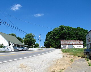
Turtletown is an unincorporated community in Polk County, Tennessee, United States. Turtletown is located on Tennessee State Route 68 6.5 miles (10.5 km) north-northeast of Ducktown. Turtletown is in a primarily mountainous terrain, covered in forests except for areas cleared by farmers, ponds, or roads. Turtletown has a post office with ZIP code 37391. Turtletown's borders, however, in the eyes of some are disputed. According to one, parts of it are known as Dogtown, which appears on a few local maps. However, to others, it is simply all Turtletown and Dogtown does not exist. The only known map that contains this is the USGS map of the area, and a U.S. Forest Service map. There is an abandoned school, Turtletown School, across the street from the Post Office.
Delano is an unincorporated community in Polk County, Tennessee, United States. It is located near the junction of U.S. Route 411, Tennessee State Route 30 and Tennessee State Route 163 4.3 miles (6.9 km) south-southwest of Etowah. Delano has a post office with ZIP code 37325, which opened on August 14, 1909.
Old Fort is an unincorporated community in Polk County, Tennessee, United States. Old Fort is located along U.S. Route 411, Tennessee State Route 33 and a CSX Transportation line 8.75 miles (14.08 km) south-southwest of Benton. Oldfort has a post office with ZIP code 37362.
Macon is an unincorporated community in Fayette County, Tennessee, United States. The community is located at the intersection of two state highways, State Route 193 and State Route 194. Its ZIP Code is 38048.

Smartt is an unincorporated community in Warren County, Tennessee, United States. Smartt is located along Tennessee State Route 55 and the Caney Fork and Western Railroad 4.5 miles (7.2 km) southwest of McMinnville. Smartt has a post office with ZIP code 37378.
Moss is an unincorporated community in Clay County, Tennessee, United States.
Only is an unincorporated community in Hickman County, Tennessee, United States. Only is located on Tennessee State Route 229 near Tennessee State Route 50 and Interstate 40, 13.9 miles (22.4 km) west-northwest of Centerville. Only has a post office, with ZIP code 37140.

Bloomington Springs is an unincorporated community in Putnam County, Tennessee, United States. It has a post office, with ZIP code 38545. It is concentrated around the intersection of Tennessee State Route 56 and Tennessee State Route 291, north of Baxter and west of Cookeville.
Beechgrove, also known as Beech Grove, is an unincorporated community in Coffee County, Tennessee, United States. Beechgrove is located in northwestern Coffee County at the junction of Interstate 24, U.S. Route 41, and State Route 64. Beechgrove has a post office with ZIP code 37018.

Pruden is an unincorporated community located partly in Bell County, Kentucky and partly in Claiborne County, Tennessee, in the southeastern United States. It is located along Tennessee State Route 90 and Kentucky Route 74, which intersect at the state line, in the upper Clearfork Valley.
Nunnelly is an unincorporated community in Hickman County, Tennessee, United States. Nunnelly is located at the junction of state routes 48 and 230, 5.6 miles (9.0 km) north of Centerville. Nunnelly has a post office, with ZIP code 37137.

Mulberry is an unincorporated community in Lincoln County, Tennessee, United States. Mulberry is located along Tennessee State Route 50, 7.4 miles (11.9 km) northeast of Fayetteville. Mulberry has a post office with ZIP code 37359, which opened on January 7, 1828. The community was named for the red mulberry plants found in the area.

Pioneer is an unincorporated community in Campbell County, Tennessee, United States. Its ZIP code is 37847. It is situated in the upper Cove Creek Valley at the intersection of Tennessee State Route 297 and Tennessee State Route 63.

Pelham is an unincorporated community and census-designated place (CDP) in Grundy County, Tennessee, United States. As of the 2010 census, its population was 403. Pelham is located at the junction of U.S. Route 41, State Route 2, and State Route 50 near the base of the Cumberland Plateau, 5.35 miles (8.61 km) north-northwest of Monteagle. Pelham has a post office with ZIP code 37366, which opened on April 4, 1832.
Cecil is an unincorporated community in Montgomery County, Alabama, United States. Cecil is located on Alabama State Route 110, 17.6 miles (28.3 km) east-southeast of Montgomery. Cecil had a post office until it closed on May 20, 1986; it still has its own ZIP code, 36013.


