Related Research Articles

Morton County is a county in the U.S. state of North Dakota. As of the 2020 census, the population was 33,291, making it the seventh-most populous county in North Dakota. Its county seat is Mandan. Morton County is included in the Bismarck, ND, Metropolitan Statistical Area.
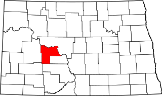
Mercer County is a county in the U.S. state of North Dakota. As of the 2020 census, the population was 8,350. Its county seat is Stanton.

Glen Ullin is a city in Morton County, North Dakota, United States. It is part of the "Bismarck, ND Metropolitan Statistical Area" or "Bismarck-Mandan". The population was 732 at the 2020 census.
Ada is a township in Dickey County, North Dakota, United States. Its population during the 2000 Census was 60, and was estimated at 52 in 2009. Its population in 1900 was 232.
Adler Township is one of the twenty-seven townships of Nelson County, North Dakota, United States. Its population during the 2000 Census was 47, and an estimated 38 as of 2009.
Advance Township is a township in Pembina County, North Dakota, United States. At the time of the 2000 Census, its population was 143, with an estimated 122 people as of 2009.
Akra Township is a township in Pembina County, North Dakota, United States.

Raleigh is a census-designated place (CDP) in Grant County, North Dakota, United States. An unincorporated community, it was designated as part of the U.S. Census Bureau's Participant Statistical Areas Program on March 31, 2010. It was not counted separately during the 2000 Census, but was included in the 2010 Census, where a population of 12 was reported.

Beisigl Township is a township in Adams County, North Dakota, United States. As of the 2010 census, its population was 22.
Edna Township is a civil township in Barnes County in the U.S. state of North Dakota. As of the 2000 Census, its population was 74. It is the 20th largest township in the county in terms of both total population and population density.
Mission Township is a civil township in Benson County, North Dakota, United States. As of the 2000 census, its population was 1,077. It is the most populous township in the county.

Cecil Township is a civil township in Bottineau County in the U.S. state of North Dakota. As of the 2000 census, its population was 28.

Haram Township is a civil township in Bottineau County in the U.S. state of North Dakota. As of the 2000 census, its population was 85.

Porcupine is a census-designated place in Sioux County, North Dakota, United States. It lies only a few minutes' drive from the city of Selfridge. The community includes the headquarters of the Selfridge/Porcupine district.
Freda Township is a township in Grant County, North Dakota, United States. Its population as of the 2000 Census was 12. It lies in the eastern part of the county along the Cannonball River.
Custer Township is the name shared by former townships in Morton County, North Dakota, United States. Both townships were organized at different times in two different parts of the county.
Schrunk Township is a civil township in Burleigh County in the U.S. state of North Dakota. As of the 2000 census, its population was 26, but had increased to an estimated 71 by 2009.
Brandenburg Township is a civil township located in Richland County, North Dakota, United States. Its population during the 2000 Census was 142, and estimated to be 126 as of 2009.
Saddle Butte Township is a township in Golden Valley County, North Dakota, United States. Its population was 25 as of the 2010 census, down from 27 in 2000.
Apple Valley is an unincorporated community and census-designated place (CDP) in Burleigh County, North Dakota, United States. It was first listed as a CDP prior to the 2020 census.
References
- 1 2 U.S. Census Bureau (1992). "Population and Housing Unit Counts, North Dakota" (PDF). 1990 Census of Population and Housing. Government Printing Office . Retrieved 2008-07-20.
- ↑ "US Board on Geographic Names". United States Geological Survey. 2007-10-25. Retrieved 2008-01-31.
- ↑ U.S. Census Bureau (1931). "Number and Distribution of Inhabitants, North Dakota" (PDF). Fifteenth Census of the United States: 1930. Government Printing Office . Retrieved 2008-07-20.
- ↑ U.S. Census Bureau (1963). "Number of Inhabitants, North Dakota" (PDF). Census of Population: 1960. Government Printing Office . Retrieved 2008-07-20.
- 1 2 "Big Muddy Creek". Geographic Names Information System . United States Geological Survey, United States Department of the Interior . Retrieved 2010-06-23.
"Curlew Valley". Geographic Names Information System . United States Geological Survey, United States Department of the Interior . Retrieved 2010-06-23. - ↑ Wick, Douglas A. (1988). North Dakota Place Names. Bismarck, North Dakota: Hedemarken Collectibles. pp. 42–43. ISBN 0-9620968-0-6. OCLC 191277027.
- ↑ Williams, Mary Ann (Barnes) (1966). Origins of North Dakota Place Names. Bismarck, North Dakota: Bismarck Tribune, 1966. p. 195. OCLC 431626.
Municipalities and communities of Morton County, North Dakota, United States | ||
|---|---|---|
| Cities |  | |
| Township | ||
| CDP | ||
| Unincorporated communities | ||
Coordinates: 46°48′54″N101°49′48″W / 46.81500°N 101.83000°W
| | This North Dakota location article is a stub. You can help Wikipedia by expanding it. |