Damiansville, Illinois

Last updated

Damiansville, Illinois
Nickname: 
the town of pointers
Clinton County Illinois Incorporated and Unincorporated areas Damiansville Highlighted.svg
Location of Damiansville in Clinton County, Illinois.
Illinois in United States (US48).svg
Location of Illinois in the United States
Coordinates: 38°30′32″N89°36′54″W / 38.50889°N 89.61500°W / 38.50889; -89.61500 [1]
CountryUnited States
StateIllinois
County Clinton
Government
  Village presidentHerman Jansen [2]
Area
[3]
  Total0.82 sq mi (2.13 km2)
  Land0.82 sq mi (2.13 km2)
  Water0.00 sq mi (0.00 km2)
Elevation
[1]
430 ft (130 m)
Population
 (2020)
  Total564
  Density686.13/sq mi (265.03/km2)
Time zone UTC-6 (CST)
  Summer (DST) UTC-5 (CDT)
ZIP Code(s)
62215
Area code 618
FIPS code 17-18472
GNIS feature ID2398675 [1]
Wikimedia CommonsDamiansville, Illinois
Website www.damiansville.org

Damiansville is a village in Clinton County, Illinois, United States. The population was 564 at the 2020 census, up from 491 at the 2010 census. [4]

Contents

Geography

Interstate 64 runs along the southern border of the village, with access from Exit 34, and leads 35 miles (56 km) west to St. Louis and 43 miles (69 km) east to Mount Vernon.

According to the 2021 census gazetteer files, Damiansville has a total area of 0.82 square miles (2.12 km2), all land. [5]

Demographics

Historical population
CensusPop.Note
1880 96
1980 396
1990 379−4.3%
2000 368−2.9%
2010 49133.4%
2020 56414.9%
U.S. Decennial Census [6]

As of the 2020 census [7] there were 564 people, 205 households, and 152 families residing in the village. The population density was 686.13 inhabitants per square mile (264.92/km2). There were 191 housing units at an average density of 232.36 per square mile (89.71/km2). The racial makeup of the village was 75.53% White, 0.71% African American, 0.71% Asian, 3.72% from other races, and 19.33% from two or more races. Hispanic or Latino of any race were 20.39% of the population.

There were 205 households, out of which 40.5% had children under the age of 18 living with them, 66.34% were married couples living together, 3.90% had a female householder with no husband present, and 25.85% were non-families. 18.54% of all households were made up of individuals, and 7.80% had someone living alone who was 65 years of age or older. The average household size was 2.82 and the average family size was 2.54.

The village's age distribution consisted of 22.4% under the age of 18, 6.4% from 18 to 24, 35% from 25 to 44, 23.1% from 45 to 64, and 13.1% who were 65 years of age or older. The median age was 33.7 years. For every 100 females, there were 132.9 males. For every 100 females age 18 and over, there were 131.1 males.

The median income for a household in the village was $70,375, and the median income for a family was $71,667. Males had a median income of $39,500 versus $33,000 for females. The per capita income for the village was $34,250. About 0.7% of families and 2.9% of the population were below the poverty line, including 0.0% of those under age 18 and 5.4% of those age 65 or over.

Education

It is in the service area of Central Community High School, formed as a consolidation of the Breese and Aviston high schools in 1971. [8]

Related Research Articles

<span class="mw-page-title-main">Camp Point, Illinois</span> Village in Illinois, United States

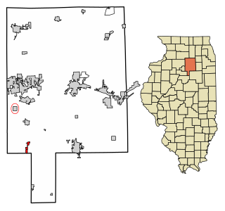
Camp Point is a village in Adams County, Illinois, United States. The population was 1,121 at the 2020 census, down from 1,132 at the 2010 census. It is part of the Quincy, IL–MO Micropolitan Statistical Area.

<span class="mw-page-title-main">La Prairie, Illinois</span> Town in Illinois, United States

La Prairie is a village in Adams County, Illinois, United States. The population was 42 at the 2020 census. It is part of the Quincy, IL–MO Micropolitan Statistical Area.

<span class="mw-page-title-main">Old Ripley, Illinois</span> Village in Illinois, United States

Old Ripley is a village in Bond County, Illinois, United States. The population was 82 at the 2020 census.

<span class="mw-page-title-main">Mound Station, Illinois</span> Village in Illinois, United States

Mound Station (Timewell) is a village in Brown County, Illinois, United States. The population was 117 at the 2020 census.

<span class="mw-page-title-main">Bureau Junction, Illinois</span> Village in Illinois, United States

Bureau Junction, usually called Bureau, is a village in Bureau County, Illinois, United States. The population was 281 at the 2020 census. The village name is shown as both "Bureau Junction" and "Bureau" on federal maps, and is commonly called "Bureau", including by phone companies and the United States Post Office. It is part of the Ottawa Micropolitan Statistical Area. Bureau Junction was the point where the Rock Island Line railroad's branch line to Peoria split. Track west and south of Bureau is operated by Iowa Interstate, while tracks east to Chicago were formerly operated by CSX but are currently leased to Iowa Interstate.

<span class="mw-page-title-main">Dalzell, Illinois</span> Village in Illinois, United States

Dalzell is a village in Bureau and LaSalle counties in the U.S. state of Illinois. The population was 663 at the 2020 census, down from 717 at the 2010 census. It is part of the Ottawa Micropolitan Statistical Area. Dalzell was founded on November 24, 1903, and certified on February 11, 1904.

<span class="mw-page-title-main">Malden, Illinois</span> Village in Illinois, United States

Malden is a village in Bureau County, Illinois, United States. The population was 318 at the 2010 census. It is part of the Ottawa, IL Micropolitan Statistical Area.

<span class="mw-page-title-main">Ashland, Illinois</span> Village in Illinois, United States

Ashland is a village in Cass County, Illinois, United States. The population was 1,218 at the 2020 census.

<span class="mw-page-title-main">Ludlow, Illinois</span> Village in Illinois, United States

Ludlow is a village in Champaign County, Illinois, United States. The population was 308 at the 2020 census.

<span class="mw-page-title-main">Albers, Illinois</span> Village in Illinois, United States

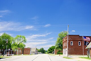
Albers is a village in Clinton County, Illinois, United States. The population was 1,121 at the 2020 census.

<span class="mw-page-title-main">Thornton, Illinois</span> Village in Illinois, United States

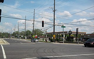
Thornton is a village in Cook County, Illinois, United States and a south suburb of Chicago. The population was 2,386 at the 2020 census. Thornton is home to the Thornton Quarry, one of the largest quarries in the world.

<span class="mw-page-title-main">Wapella, Illinois</span> Village in Illinois, United States

Wapella is a village in DeWitt County, Illinois, United States. The population was 513 at the 2020 census.

<span class="mw-page-title-main">St. Peter, Illinois</span> Village in Illinois, United States

St. Peter or Saint Peter is a village in Fayette County, Illinois, United States. The population was 322 at the 2020 census.

<span class="mw-page-title-main">Valier, Illinois</span> Village in Illinois, United States

Valier is a village in Franklin County, Illinois, United States. The population was 554 at the 2020 census.

<span class="mw-page-title-main">Rockbridge, Illinois</span> Village in Illinois, United States

Rockbridge is a village in Greene County, Illinois, United States. The population was 175 at the 2020 census.

<span class="mw-page-title-main">Godley, Illinois</span> Village in Illinois, United States

Godley is a village in Grundy and Will counties, Illinois, United States. The population was 566 at the 2020 census.

<span class="mw-page-title-main">West Point, Illinois</span> Village in Illinois, United States

West Point is a village in Hancock County, Illinois, United States. The population was 178 at the 2010 census.

<span class="mw-page-title-main">Leland, Illinois</span> Village in Illinois, United States

Leland is a village in LaSalle County, Illinois, United States. The population was 951 at the 2020 census. It is part of the Ottawa Micropolitan Statistical Area.

<span class="mw-page-title-main">Lostant, Illinois</span> Village in Illinois, United States

Lostant is a village in LaSalle County, Illinois, United States. The population was 423 at the 2020 census, down from 498 at the 2010 census. It is part of the Ottawa Micropolitan Statistical Area.

<span class="mw-page-title-main">Florence, Illinois</span> Village in Illinois, United States

Florence is a village in Pike County, Illinois, United States. The population was 17 at the 2020 census, making Florence the second-least populated municipality in Illinois.

References

  1. 1 2 3 U.S. Geological Survey Geographic Names Information System: Damiansville, Illinois
  2. "Municipalities | Clinton County, Illinois" . Retrieved July 20, 2022.
  3. "2020 U.S. Gazetteer Files". United States Census Bureau. Retrieved March 15, 2022.
  4. "Geographic Identifiers: 2010 Demographic Profile Data (G001): Damiansville village, Illinois". U.S. Census Bureau, American Factfinder. Archived from the original on February 12, 2020. Retrieved August 1, 2014.
  5. Bureau, US Census. "Gazetteer Files". Census.gov. Retrieved June 29, 2022.
  6. "Census of Population and Housing". Census.gov. Retrieved June 4, 2015.
  7. "Explore Census Data". data.census.gov. Retrieved June 28, 2022.
  8. "School / District / Community Profile" (PDF). Central Community High School. Retrieved April 5, 2020.