
Ladakh is a region administered by India as a union territory and constitutes an eastern portion of the larger Kashmir region that has been the subject of a dispute between India and Pakistan since 1947 and India and China since 1959. Ladakh is bordered by the Tibet Autonomous Region to the east, the Indian state of Himachal Pradesh to the south, both the Indian-administered union territory of Jammu and Kashmir and the Pakistan-administered Gilgit-Baltistan to the west, and the southwest corner of Xinjiang across the Karakoram Pass in the far north. It extends from the Siachen Glacier in the Karakoram range to the north to the main Great Himalayas to the south. The eastern end, consisting of the uninhabited Aksai Chin plains, is claimed by the Indian Government as part of Ladakh, but has been under Chinese control.

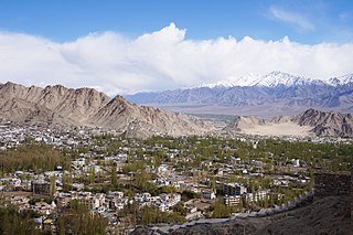
Leh is a city in Indian-administered Ladakh in the disputed Kashmir region. It is the largest city and the joint capital of Ladakh. Leh, located in the Leh district, was also the historical capital of the Kingdom of Ladakh. The seat of the kingdom, Leh Palace, the former residence of the royal family of Ladakh, was built in the same style and about the same time as the Potala Palace in Tibet. Since they were both constructed in a similar style and at roughly the same time, the Potala Palace in Tibet and Leh Palace, the royal residence, are frequently contrasted. Leh is at an altitude of 3,524 m (11,562 ft), and is connected via National Highway 1 to Srinagar in the southwest and to Manali in the south via the Leh-Manali Highway.

Baltistan also known as Baltiyul or Little Tibet, is a mountainous region in the Pakistani-administered territory of Gilgit-Baltistan and constitutes a northern portion of the larger Kashmir region that has been the subject of a dispute between India and Pakistan since 1947. It is located near the Karakoram and borders Gilgit to the west, China's Xinjiang to the north, Indian-administered Ladakh to the southeast, and the Indian-administered Kashmir Valley to the southwest. The average altitude of the region is over 3,350 metres (10,990 ft). Baltistan is largely administered under the Baltistan Division.

Kargil district is a district in Indian-administered Ladakh in the disputed Kashmir-region, which is administered as a union territory of Ladakh. It is named after the city of Kargil, where the district headquarters lies. The district is bounded by the Indian-administered union territory of Jammu and Kashmir to the west, the Pakistani-administered administrative territory of Gilgit–Baltistan to the north, Ladakh's Leh district to the east, and the Indian state of Himachal Pradesh to the south. Encompassing three historical regions known as Purig, Dras and Zanskar, the district lies to the northeast of the Great Himalayas and encompasses the majority of the Zanskar Range. Its population inhabits the river valleys of the Dras, Suru, Wakha Rong, and Zanskar.

Skardu is a city located in Pakistan-administered Gilgit-Baltistan in the disputed Kashmir region. Skardu serves as the capital of Skardu District and the Baltistan Division. It is situated at an average elevation of nearly 2,500 metres above sea level in the Skardu Valley, at the confluence of the Indus and Shigar rivers. It is an important gateway to the eight-thousanders of the nearby Karakoram mountain range. The Indus River running through the region separates the Karakoram from the Ladakh Range.
Leh district is a district in Indian-administered Ladakh in the disputed Kashmir-region. Ladakh is an Indian-administered union territory. With an area of 45,110 km2, it is the second largest district in the country, second only to Kutch. It is bounded on the north by Gilgit-Baltistan's Kharmang and Ghanche districts and Xinjiang's Kashgar Prefecture and Hotan Prefecture, to which it connects via the historic Karakoram Pass. Aksai Chin and Tibet are to the east, Kargil district to the west, and Lahul and Spiti to the south. The district headquarters is in Leh. It lies between 32 and 36 degree north latitude and 75 to 80 degree east longitude.

Kargil or Kargyil is a city in Indian-administered Ladakh in the disputed Kashmir region. It is the joint capital of Ladakh, an Indian-administered union territory. It is also the headquarters of the Kargil district. It is the second-largest city in Ladakh after Leh. Kargil is located 204 kilometres (127 mi) east of Srinagar in Jammu and Kashmir, and 234 kilometres (145 mi) to the west of Leh. It is on the bank of the Suru River near its confluence with the Wakha Rong river, the latter providing the most accessible route to Leh.
Ladakh has a long history with evidence of human settlement from as back as 9000 b.c. It has been a crossroad of high Asia for thousands of years and has seen many cultures, empires and technologies born in its neighbours. As a result of these developments Ladakh has imported many traditions and culture from its neighbours and combining them all gave rise to a unique tradition and culture of its own.
Batalik is a village and military base in Ladakh, India, located in a narrow section of the Indus River valley, close to the Line of Control with Pakistan-administered Baltistan. It was a focal point of the 1999 Kargil War because of its strategic location between Kargil, Leh and Baltistan.

Dras, also known locally in Shina as Himababs, Hembabs, or Humas, is a town and hill station, and the headquarters of Drass district of the union territory of Ladakh in India. It is on the NH 1 between Zoji La pass and Kargil. A tourist hub for its high-altitude trekking routes and tourist sites, it is often called "The Gateway to Ladakh". The government's official spelling of the town's name is "Drass".

Chorbat Valley is a section of the Shyok river valley divided between Pakistan-administered Gilgit-Baltistan and Indian-administered Ladakh. The Pakistan-administered portion is in the Khaplu tehsil of Ghanche District in Gilgit–Baltistan, and the Indian-administered portion is in the Nubra tehsil, Leh district of Ladakh. Chorbat stretches from the edge of Khaplu to the Chalunka village of Nubra.
Hanu is a village panchayat in the Khalsi tehsil in the Leh district of Ladakh, India. It is one of the main Brokpa villages in Ladakh. It is in the valley of the Hanu stream that flows from the Chorbat La pass to drain into the Indus river.
Dah is a panchayat village in the Leh district of Ladakh, India. It is the most prominent of all the Brokpa settlements, other than Dah, it has six hamlets: Biama(or phunder), Baldes, Sannit, Pardos, Lastyang and Dundur It is located east of Batalik in Aryan Valley of Indus river of Ladakh in the Khalsi tehsil.
Garkon is a panchayat village in the Aryan valley region located in the Kargil block of Kargil district, in a rural region of the Indian union territory of Ladakh. It is located east of Batalik in Aryan Valley of Indus river system.
Hardas is a village in Kargil district of the Indian union territory of Ladakh, close to the India–Pakistan border (LOC). The village is located 10 kilometres north of Kargil, the district headquarters, on the left of the Dras River.
Chulichan is a village in the Kargil district of Ladakh, India, close to the Line of Control with Pakistan-administered Kashmir. It is populated by Shia Brokpas and Baltis.

Aryan Valley, historically known as Dah Hanu region, is an area comprising four village clusters — Dah and Hanu in Leh district, and Garkon and Darchik in Kargil district — in Central Ladakh in India. It is inhabited by Brokpa people of Dardic origin. Until its absorption into the Maryul kingdom, Brokpa chiefs wielded nominal autonomy in the region.
Ganokh, locally called Ganishah, is a village in the Kharmang District of Baltistan, Pakistan, close to the Line of Control with Indian-administered Ladakh. It is populated by Brokpas professing Shia Islam.

Brokpa, Drokpa, Dard and Shin is a category of Scheduled Tribes under the Indian constitution.
Marol is a village situated near the confluence of the Suru River and the Indus River in the Kharmang District of Baltistan, Pakistan. It is close to the India–Pakistan border (LOC).

