Mount Morrison is located in the Sierra Nevada, in the Sherwin Range. It rises south of Convict Lake near the town of Mammoth Lakes.

Loch Leven is the name of several lakes in California, United States, in the Sierra Nevada.

Mount Darwin is a flat-topped mountain in the Sierra Nevada, on the border of between Fresno and Inyo counties in Kings Canyon National Park and the John Muir Wilderness of California.

Mount Sill is one of the fourteeners of the Sierra Nevada in California. It is located in the Palisades, a group of striking rock peaks with a few small glaciers on their flanks. Mount Sill is located 0.6 miles (1 km) east of North Palisade, the high point of the group. The two peaks are connected by a high, rocky ridge, on the north side of which lies the Palisade Glacier. Mount Sill lies on the main Sierra Crest, but is at a point where the crest turns sharply, giving it particularly striking summit views. On one side is Kings Canyon National Park and Fresno County; on the other is the John Muir Wilderness, Inyo National Forest and Inyo County.

Mount Conness is a 12,590 foot (3,840 m) mountain in the Sierra Nevada range, to the west of the Hall Natural Area. Conness is on the boundary between the Inyo National Forest and Yosemite National Park. The Conness Glacier lies north of the summit.

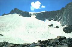
The Palisade Glacier is a glacier located on the northeast side of the Palisades within the John Muir Wilderness in the central Sierra Nevada of California. The glacier descends from the flanks of four mountain peaks over 14,000 ft (4,300 m) in elevation of which North Palisade is third highest peak in the Sierra Nevada Range.
Lyell Glacier is in the Sierra Nevada of California. The glacier was discovered by John Muir in 1871, and was the largest glacier in Yosemite National Park. It lies on the northern slopes of Mount Lyell.
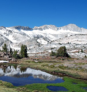
The Conness Glacier is on the steep northeast cirque of Mount Conness, east of the Sierra Nevada crest, in the U.S. state of California. The glacier is situated at about 11,548 feet (3,520 m). and can be seen from Saddlebag Lake to the east. The glacier is the largest glacier in the Sierra Nevada north of Tioga Pass or Highway 120.
The Konwakiton Glacier is a glacier situated on the southern flank of Mount Shasta, in the U.S. state of California. It occupies the head of a large cirque on the south side of Shasta's Misery Hill cone, just northeast of the prominent outcrop of Thumb Rock at about 11,500 ft (3,500 m). It is the fifth largest glacier on Mount Shasta, although less than one-third the size of any of the four larger ones. The Konwakiton is the most frequently visited of Shasta's glaciers, since the standard climbing route up Avalanche Gulch skirts along its western edge above Thumb Rock saddle, with the boot track often only a few feet from the bergschrund at the glacier's head.

Maclure Glacier is on Mount Maclure in the Sierra Nevada crest of Yosemite National Park in Tuolumne County, California, United States. The glacier is named after William Maclure. Like most glaciers in the Sierra Nevada, Maclure Glacier is a small cirque glacier that is .20 mi (0.32 km) long and covers an area of only .08 sq mi (0.21 km2). The mean elevation of the glacier is around 11,400 ft (3,500 m). Both the Maclure Glacier and the Lyell Glacier, located nearby on Mount Lyell, have retreated since their first discovery.
Lilliput Glacier is the smallest named glacier in the Sierra Nevada of California. The glacier has an area of .05 km2 (0.019 sq mi), which is approximately 12.2 acres. In terms of area this is about the size of 48 typical suburb lots that single family home are built on. This glacier lies on the shaded north-facing vertical cliff of Mount Stewart, being the southernmost named glacier in the United States.
Norman Clyde Glacier is a small glacier located in the crest of the Sierra Nevada Range in the John Muir Wilderness of Inyo National Forest in Inyo County, California. The glacier is northwest of Norman Clyde Peak and both are named after California mountaineer Norman Clyde. A small ridge separates the glacier from the adjacent but larger Middle Palisade Glacier located less than .25 mi (0.40 km) to the southeast.

Middle Palisade Glacier consists of two glaciers in the Sierra Nevada mountains, in the U.S. state of California. Less than .25-mile (0.40 km) southeast of Norman Clyde Glacier and situated at an altitude of 12,700 feet (3,900 m), Middle Palisade Glacier is in the John Muir Wilderness of Inyo National Forest. 14,012-foot (4,271 m) Middle Palisade is immediately west of the glacier.
Mount Maclure is the nearest neighbor to Mount Lyell, the highest point in Yosemite National Park. Mount Maclure is the fifth-highest mountain of Yosemite. Mount Maclure is located at the southeast end of the Cathedral Range, about 0.6 miles (0.97 km) northwest of Lyell. The summit is on the boundary between Madera and Tuolumne counties which is also the boundary between the park and the Ansel Adams Wilderness. It was named in honor of William Maclure, a pioneer in American geology who produced the first geological maps of the United States. Maclure Glacier, one of the last remaining glaciers in Yosemite, is situated on the mountain's northern flank.
The Matthes Glaciers are a group of glaciers east of the Glacier Divide in the Sierra Nevada, in the U.S. state of California. The glaciers were named for François E. Matthes. There are approximately 10 small glacierets situated above 12,200 feet (3,700 m) in the John Muir Wilderness of Sierra National Forest which comprise the Matthes Glaciers.
Mendel Glacier is on the north side of Mount Mendel in the Sierra Nevada, California. The name is commonly used; however, the name is not recognized by the United States Geological Survey in the Geographic Names Information System. Mendel Glacier is .35 miles (0.56 km) north of Darwin Glacier at 12,500 feet (3,800 m) above sea level.
Goethe Glacier is a small glacier located in the Sierra Nevada Range in the John Muir Wilderness of Sierra National Forest in the U.S. state of California. The glacier is northwest of Mount Goethe.
Mount Fiske Glacier is a small glacier located in the Sierra Nevada Range within Kings Canyon National Park in the U.S. state of California. The glacier is on the north slope of Mount Fiske and .70 mi (1.13 km) northwest of Mount Warlow Glacier.
Mount Warlow Glacier is a small glacier located in the Sierra Nevada Range within Kings Canyon National Park in the U.S. state of California. The glacier is on the northwest slope of Mount Warlow and is .70 mi (1.13 km) southwest of Mount Fiske Glacier.
Powell Glacier is located in the Sierra Nevada Range in the U.S. state of California. Just to the northeast of Mount Powell, the glacier is within the John Muir Wilderness of Inyo National Forest at an elevation of 12,523 ft (3,817 m).