Dasharathchand

Last updated
Dasharathchand
दशरथचन्द
Baitadi (12).JPG
Hill station, Dashrathchanda
Nepal Sudurpashchim Pradesh adm location map.svg
Red pog.svg
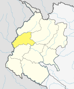
Dasharathchand
Location of Dasharathchanda in Sudurpashchim
Nepal adm location map.svg
Red pog.svg
Dasharathchand
Dasharathchand (Nepal)
Coordinates: 29°33′17″N80°25′36″E / 29.55472°N 80.42667°E / 29.55472; 80.42667
Country Nepal
Province Sudurpashchim Province
District Baitadi District
Wards 11
Established1997
Government
  Type Mayor-council
   Mayor Puskar Raj Joshi
   Deputy Mayor Kausalia Chand
Area
  Total135.15 km2 (52.18 sq mi)
Population
 (2011)
  Total34,575
  Density260/km2 (660/sq mi)
  Religions
Hindu
Time zone UTC+5:45 (NST)
Postal code
10200
Area code 095
Website dasharathchandmun.gov.np

Dasharathchand is a municipality and the district headquarter of Baitadi District in Sudurpashchim Province of Nepal. It is a hill station above Mahakali River close to the Indian border. At the time of the 2011 Nepal census it had a population of 34,575 people living in 7,257 individual households. [1]

Contents

Background

Dasharatchand municipality was established in 1997 at the time, when the government of Nepal established a total of 22 Municipalities. [2] Six VDCs were merged while establishing this municipality. Those VDCs were: Dashrathchanda, Khalanga, Tripurasundari, Thalegada, Jogannath and Barakot. [3] According to the 2011 Nepal census its total population was 17,427 and total area was 55.01 square kilometres (21.24 sq mi). It was divided into 13 wards. [4]

In March 2017, the Government of Nepal restructured all the local level bodies of Nepal into 753 new local level structures. [5] [6] The previous Gurukhola, Dehimandau, Durga Bhabani, portion of Durgasthan, Gwallek and Nagarjun VDCs merged to the former Dashrathchanda Municipality and rearranged it into 11 wards. Now total population of the Dashrathchanda Municipality is 34,575 individuals and total area is 135.15 square kilometres (52.18 sq mi). [7]

Media

To promote local culture, Dasharathchanda has two FM radio stations  Saugat F.M. (103.6 MHz) and Radio Sunsher (106.6 MHz). There is also Radio Nwedeu,[ clarification needed ] a community radio station.[ citation needed ]

Transportation

Mahakali Highway links Dasharathchand to Dhangadhi in the South and Api Municipality in the North. [8]

Related Research Articles

<span class="mw-page-title-main">Phungling Municipality</span> Municipality in Province No. 1, Nepal

Phungling Municipality is a municipality located in Taplejung District in the Province No. 1 of Nepal. The municipality was formed merging the then two Village Development Committees of Phungling and Dokhu in May 2014. At the time of the 2011 Nepal census it had a population of 19,085 people and 4,480 individual households.

<span class="mw-page-title-main">Baitadi District</span> District in Sudurpashchim Province, Nepal

Baitadi District, historical name “Bairath” (बैराथ), a part of Sudurpashchim Province, is one of the 77 districts of Nepal. It is a Hill district. Baitadi, with Dasharathchand as its headquarters, covers an area of 1,519 km2 (586 sq mi) and has a population of 250,898 according to the census (2011). The Baitadi district entails 56 village development councils (VDCs) and two municipality in the past. Now, by federal policy there are 10 local units; 4 Municipalities and 6 Rural Municipalities. Baitadi falls into the farthest western regional district of Nepal touching Jhulaghat, India, Nepal's neighboring country, to its border.

<span class="mw-page-title-main">Darchula District</span> District in Sudurpashchim Province, Nepal

Darchula District (Nepali: दार्चुला जिल्लाpronounced [ˈdaɾt͡sula], a part of Sudurpashchim Province, is one of the nine districts of province and one of seventy-seven districts of Nepal. The district, with Khalanga as its district headquarters, covers an area of 2,322 km2 and has a population of 133,274. Darchula Lies in the west-north corner of the country.

<span class="mw-page-title-main">Kanchanpur District</span> District in Sudurpashchim Province, Nepal

Kanchanpur District, a part of Sudurpashchim Province in the Terai plain, is one of seventy seven districts of Nepal. The district, with Bhimdatta as its district headquarters, covers an area of 1,610 square kilometres (620 sq mi) and had a population of 134,868 in 2001 and 171,304 in 2011. It is located in south-western of Nepal. It is bordered by Kailali district in the east, Dadeldhura district in the north and with India in the south and west.

<span class="mw-page-title-main">Damak Municipality</span> Municipality in Nepal

Damak, a city in eastern Nepal is one of the oldest municipalities in Jhapa District in Koshi Pradesh in eastern Nepal. It is situated between the Ratuwa River in the east and the Maawa River in the west. It has Sivalik Hills in its north and ends with the intersection of Ratuwa River and Maawa River in the south. Mahendra Highway crosses this municipality nearly bisecting it. It is the third largest city in Jhapa District with a population of 107,410 in 2021 A.D

<span class="mw-page-title-main">Triyuga Municipality</span> Municipality in Koshi Pradesh, Nepal

Triyuga is one of eight municipalities of Udayapur district of the Koshi Pradesh of Nepal. Gaighat is the headquarter of the municipality. According to the 1991 Nepal census, it had a population of 55,291. According to the 2011 Nepal census, Triyuga had 87,557 inhabitants. According to the 2021 Nepal census the initial population of the municipality is 104,375. It is divided into 16 wards. Triyuga Municipality was established on B.S. Chaitra 13, 2053. It was named after Triyuga River. A river which flows through the town. Triyuga is the 3rd largest municipality in Nepal and 1st largest in Koshi Pradesh in term of size (area). The total area of the municipality is 547.43 square kilometres (211.36 sq mi)

<span class="mw-page-title-main">Putalibazar</span> Municipality in Gandaki Province, Nepal

Putalibazar, is a municipality and district headquarters in Syangja District in Gandaki Province of central Nepal. Putalibazar is a famous city of Syangja District.

<span class="mw-page-title-main">Solududhkunda Municipality</span> Municipality in Province No. 1, Nepal

Solududhkunda (earlier:Dudhkunda) is the only municipality of Solukhumbu District. Located in Province No. 1 of Nepal. The town of Salleri, which is located within the municipality is the headquarter of Solukhumbu District It was formed in 2014 by merging four VDCs: Salleri, Garma, Loding Tamakhani and Beni and was divided into 9 wards. Total area of the municipality had 254.3 square kilometres (98.2 sq mi) and population of municipality had 20,399 individuals living in 5,368 households.

Naubise is a village development committee in Dhading District in the Bagmati Zone of central Nepal. At the time of the 2011 Nepal census it had a population of 25621 and had 3239 houses in it.

Tulsipur is a Sub-Metropolitan City in Dang District of Lumbini Province of Nepal. As per population, it is the district's second most populous city after Ghorahi. It was established in 1992 by merging the former Village development committees Tulsipur and Amritpur. In 2014, it was expanded and the Village development committees of Urahari, Tarigaun, Pawannagar and Halwar. At the time of the 2011 Nepal census it had a population of 141,528 people living in 31,243 individual households.

<span class="mw-page-title-main">Godawari, Kailali</span> Municipality in Sudurpaschim, Nepal

Godawari is a municipality located in the Kailali District of Nepal.

Dipayal Silgadhi is a municipality and the district headquarters of Doti District in Sudurpashchim Province of Nepal. Previously, it also served as the headquarters of the Far-Western Development Region. It lies in the Lesser Himalayas on the bank of Seti River. At the time of the 2011 Nepal census it had a population of 32,941 people living in 7,447 individual households.

<span class="mw-page-title-main">Bardibas</span> Municipality in Madhesh Province, Nepal

Bardibas is a municipal area (municipality) and a town located in Mahottari District of Madhesh Province of Nepal. It is located at latitude: 26°54'6.84" to 27°08'46.90" and longitude: 85°47'42.67" to 85°56'42.97". The municipality is surrounded by Dhanusha District in the East and Sarlahi District in the West, Bagmati Province falls in the North and Bhangaha, Aurahi and Gaushala municipalities are located in the South.

<span class="mw-page-title-main">Amargadhi</span> Place in Nepal

Amargadhi is a municipality and the district headquarter of Dadeldhura District in Sudurpashchim Province of western Nepal. It was named after Gorkha General Amar Singh Thapa, who fought in the Gurkha War between 1814 and 1816 At the time of the 2011 Nepal census it had a population of 21,245 people living in 4,778 individual households.

<span class="mw-page-title-main">Kawasoti</span> Kawasoti Municipality in Gandaki Province, Nepal

Kawasoti (Nepali: कावासोती) is a municipality in Nawalpur District, Gandaki Province, Nepal. It is 31 km (19 mi) west of Bharatpur and 85 km (53 mi) east of Butwal, approximately on the middle of Mahendra Highway. The Naryani River flows south of it, and the Mahabharat Range is north of it.

Panchpokhari Thangpal is a rural municipality located in Sindhupalchok District of Bagmati Province of Nepal. The RM is surrounded by Jugal in the East, Helambu in the West, Rasuwa District covers from North and Melamchi and Indrawati falls in South of the RM.

Duhun is a rural council located in Darchula District of Sudurpashchim province in Nepal.

Shivapuri is a Rural municipality located within the Nuwakot District of the Bagmati Province of Nepal. The municipality spans 101.5 square kilometres (39.2 sq mi) of area, with a total population of 20,769 according to a 2011 Nepal census.

Pratappur is a Rural municipality located within the Parasi District of the Lumbini Province of Nepal. The rural municipality spans 87.55 square kilometres (33.80 sq mi) of area, with a total population of 41,315 according to a 2011 Nepal census.

References

  1. "National Population and Housing Census 2011" (PDF). Central Bureau of Statistics. November 2017. Archived from the original (PDF) on 27 January 2018. Retrieved 1 May 2018.
  2. "Population Monograph of Nepal Vol-3" (PDF). Central Bureau of Statistics. 2014. Retrieved 3 February 2021.
  3. "Official website of Dashrathchanda Municipality". Dashrathchanda Municipality. Retrieved 3 February 2021.
  4. "National Population and Housing Census 2011 (National Report)" (PDF). Central bureau of statistics. Retrieved 3 February 2021.
  5. "New local level structure comes into effect from today". www.thehimalayantimes.com. The Himalayan Times. 10 March 2017. Retrieved 17 July 2018.
  6. "New local level units come into existence". www.kathmandupost.ekantipur.com. 11 March 2017. Retrieved 18 July 2018.
  7. "District Corrected Last for RAJAPATRA" (PDF). www.mofald.gov.np. Retrieved 17 July 2018.
  8. Nepal Country Study Guide  Strategic Information and Developments. IBP USA. 2012. pp. 197–200.

Coordinates: (16791)_source:kolossus-dewiki 29°33′17″N80°25′36″E / 29.55472°N 80.42667°E / 29.55472; 80.42667