Dave Tucker (geologist)

Last updated

David Samuel Tucker [1] is a geologist, author, and union organizer in Washington state. He is a research associate at Western Washington University. [2] He was an instructor at North Cascades Institute, [3] and the director of the Mount Baker Volcano Research Center (now closed). [4] [5] [6] He writes the blog Northwest Geology Field Trips, a blog aimed at laypeople detailing where to find interesting geology in the Pacific Northwest. [7] :55 In 2015, he published a popular book on Washington geology, Geology Underfoot in Western Washington . [8] [9] [10] [11] He resides in Bellingham, Washington. [12] In the 1980s he worked as a mountaineering guide in the Cascades, Mexico, and South America. [13]

Contents

Education

Tucker is a graduate of Western Washington University: 1974 (B.S. in environmental science) and 2004 (M.S. in geology). [14] [15]

Geology research

Tucker's geologic research focuses on volcanic rocks in the Mount Baker region in the northwestern portion of the North Cascades. [16] [17] Tucker obtained a master's degree in geology at Western Washington University in 2004. His thesis mapped and described the previously little known and undefined Hannegan caldera, including geochemistry of related rocks. The 3.72-million-year-old Hannegan caldera is in the North Cascades National Park a few miles northeast of Mount Shuksan. The caldera is 8x3.5 km in area. Tucker estimated the erupted volume at around 140 km3 of rhyolite magma. The caldera is traversed by trails to Hannegan Pass, Copper Ridge, and the Chilliwack River. Ruth Mountain, Icy Peak and Hannegan Peak are the dominant geographic features in the caldera. [18] [19] [20]

Tucker assisted USGS geologist Wes Hildreth in field work that resulted in the first detailed geologic map of Mount Baker. [21] [22] He also collaborated with USGS geologist Kevin M. Scott to characterize Holocene eruption history at Mount Baker, including formation of Sherman Crater, eruption of volcanic ash (tephras) and lahars. [23] Their research culminated in a 2020 USGS Professional Paper. [24] [25]

A focus of research has been a description of the entrance of the Sulphur Creek lava flow into Glacial Lake Baker 9800 years ago. [26]

Tucker has also collaborated on studies of Mount Baker glaciers. [27] [28] [29]

From 2007 to 2013, Tucker led teams of volunteers to Sherman Crater at 9500 feet on the south flank of Mount Baker to collect fumaroles gas samples for a USGS study of hazards and potential activity at Mount Baker. He also led a team that made an ice-radar transect [30] to reveal the thickness of ice filling the 12,000- year-old Carmelo Crater [31] at the summit plateau of Mount Baker. [32] [33] [34] [35]

In 2012, Tucker, George Mustoe, and Keith Kemplin published a paper that described the fossil footprints believed to belong to Gastornis , also known as Diatryma, [36] a giant flightless bird in the Eocene Chuckanut Formation of Whatcom County. [37] [38] The track, preserved in a large sandstone slab, was found in the 2009 Racehorse Creek landslide. It was preserved by a volunteer team coordinated by Tucker and flown off the mountainside using a large helicopter to Western Washington University's Geology Department. [39] [40] [41]

IWW

Tucker has been a member of the Industrial Workers of the World since 1981, [42] in which he goes by the nickname "Tuck". [43] He served as the General Secretary-Treasurer in the union's Chicago headquarters in 1983, [44] [45] and several terms on the General Executive Board, [46] most recently in 2017–2019. [47] He is the current secretary and treasurer of the Whatcom-Skagit IWW branch. [48] [49] [50]

Tuck is an expert on the Everett massacre and the Centralia massacre, [51] [52] and has been a leader in demonstrations at the sites. [53] He has been an authority figure in the history and culture of the union in Washington and otherwise. [54] Tuck was a mentee to Carlos Cortez. [55]

Publications

Related Research Articles

A caldera is a large cauldron-like hollow that forms shortly after the emptying of a magma chamber in a volcano eruption. An eruption that ejects large volumes of magma over a short period of time can cause significant detriment to the structural integrity of such a chamber, greatly diminishing its capacity to support its own roof, and any substrate or rock resting above. The ground surface then collapses into the emptied or partially emptied magma chamber, leaving a large depression at the surface. Although sometimes described as a crater, the feature is actually a type of sinkhole, as it is formed through subsidence and collapse rather than an explosion or impact. Compared to the thousands of volcanic eruptions that occur over the course of a century, the formation of a caldera is a rare event, occurring only a few times within a given window of 100 years. Only seven caldera-forming collapses are known to have occurred between 1911 and 2016. More recently, a caldera collapse occurred at Kīlauea, Hawaii in 2018.

<span class="mw-page-title-main">Mount Baker</span> Mountain in Washington state, United States

Mount Baker, also known as Koma Kulshan or simply Kulshan, is a 10,781 ft (3,286 m) active glacier-covered andesitic stratovolcano in the Cascade Volcanic Arc and the North Cascades of Washington in the United States. Mount Baker has the second-most thermally active crater in the Cascade Range after Mount St. Helens. About 30 miles (48 km) due east of the city of Bellingham, Whatcom County, Mount Baker is the youngest volcano in the Mount Baker volcanic field. While volcanism has persisted here for some 1.5 million years, the current volcanic cone is likely no more than 140,000 years old, and possibly no older than 80–90,000 years. Older volcanic edifices have mostly eroded away due to glaciation.

<span class="mw-page-title-main">Supervolcano</span> Volcano that has erupted 1000 cubic km of lava in a single eruption

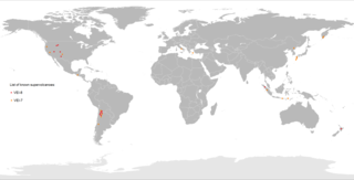
A supervolcano is a volcano that has had an eruption with a volcanic explosivity index (VEI) of 8, the largest recorded value on the index. This means the volume of deposits for such an eruption is greater than 1,000 cubic kilometers.

<span class="mw-page-title-main">Yellowstone Caldera</span> Volcanic caldera in Yellowstone National Park in the United states

The Yellowstone Caldera, sometimes referred to as the Yellowstone Supervolcano, is a volcanic caldera and supervolcano in Yellowstone National Park in the Western United States. The caldera and most of the park are located in the northwest corner of the state of Wyoming. The caldera measures 43 by 28 miles, and postcaldera lavas spill out a significant distance beyond the caldera proper.

<span class="mw-page-title-main">Mount Hampton</span> Shield volcano in Antarctica

Mount Hampton is a shield volcano with a circular ice-filled caldera. It is a twin volcano with Whitney Peak to the northwest and has erupted phonolite rocks. It is the northernmost of the volcanoes which comprise the Executive Committee Range in Marie Byrd Land, Antarctica and was active during the Miocene.

<span class="mw-page-title-main">Mount Takahe</span> Shield volcano in the Antarctic continent

Mount Takahe is a 3,460-metre-high (11,350 ft) snow-covered shield volcano in Marie Byrd Land, Antarctica, 200 kilometres (120 mi) from the Amundsen Sea. It is a c. 30-kilometre-wide (19 mi) mountain with parasitic vents and a caldera up to 8 kilometres (5 mi) wide. Most of the volcano is formed by trachytic lava flows, but hyaloclastite is also found. Snow, ice, and glaciers cover most of Mount Takahe. With a volume of 780 km3 (200 cu mi), it is a massive volcano; the parts of the edifice that are buried underneath the West Antarctic Ice Sheet are probably even larger. It is part of the West Antarctic Rift System along with 18 other known volcanoes.

<span class="mw-page-title-main">Mount Waesche</span> Volcano in Antarctica

Mount Waesche is a mountain of volcanic origin at the southern end of the Executive Committee Range in Marie Byrd Land, Antarctica. It is 3,292 metres high, and stands 20 kilometres southwest of Mount Sidley, the highest volcano in Antarctica. The mountain lies southwest of the Chang Peak caldera and is largely covered with snow and glaciers, but there are rock exposures on the southern and southwestern slopes.

<span class="mw-page-title-main">Yellowstone hotspot</span> Volcanic hotspot in the United States

The Yellowstone hotspot is a volcanic hotspot in the United States responsible for large scale volcanism in Idaho, Montana, Nevada, Oregon, and Wyoming, formed as the North American tectonic plate moved over it. It formed the eastern Snake River Plain through a succession of caldera-forming eruptions. The resulting calderas include the Island Park Caldera, Henry's Fork Caldera, and the Bruneau-Jarbidge caldera. The hotspot currently lies under the Yellowstone Caldera. The hotspot's most recent caldera-forming supereruption, known as the Lava Creek Eruption, took place 640,000 years ago and created the Lava Creek Tuff, and the most recent Yellowstone Caldera. The Yellowstone hotspot is one of a few volcanic hotspots underlying the North American tectonic plate; another example is the Anahim hotspot.

<span class="mw-page-title-main">Boring Lava Field</span> Plio-Pleistocene volcanic field in Oregon, United States

The Boring Lava Field is a Plio-Pleistocene volcanic field with cinder cones, small shield volcanoes, and lava flows in the northern Willamette Valley of the U.S. state of Oregon and adjacent southwest Washington. The field got its name from the town of Boring, Oregon, located 12 miles (20 km) southeast of downtown Portland. Boring lies southeast of the densest cluster of lava vents. The zone became volcanically active about 2.7 million years ago, with long periods of eruptive activity interspersed with quiescence. Its last eruptions took place about 57,000 years ago at the Beacon Rock cinder cone volcano; the individual volcanic vents of the field are considered extinct, but the field itself is not.

Theia Mons is a large highland shield volcano on the planet Venus. Located near the center of Beta Regio, a large region of recent volcanic uplift due to a currently active mantle plume, Theia Mons is situated at the junction of three branches of Devana Chasma, an extensive rift system. It is named after Theia, a Titan from Greek mythology; the name Theia Mons was officially approved by the International Astronomical Union (IAU) in 1979.

<span class="mw-page-title-main">Timeline of volcanism on Earth</span>

This timeline of volcanism on Earth includes a list of major volcanic eruptions of approximately at least magnitude 6 on the Volcanic explosivity index (VEI) or equivalent sulfur dioxide emission during the Quaternary period. Other volcanic eruptions are also listed.

<span class="mw-page-title-main">Ruth Mountain</span> Mountain in Washington (state), United States

Ruth Mountain is a 7,115 ft (2,170 m) Skagit Range summit located two miles south of Hannegan Pass in the North Cascades of Washington state. The name honors Ruth Cleveland, daughter of President Grover Cleveland. This mountain's name was officially adopted in 1952 by the United States Board on Geographic Names. Ruth Mountain is situated on the shared border of North Cascades National Park and the Mount Baker Wilderness, which is part of the Mount Baker-Snoqualmie National Forest. The summit offers views of Mount Shuksan, East Nooksack Glacier, Seahpo Peak, Nooksack Tower, Icy Peak, Mount Sefrit, Mineral Mountain, and the Picket Range. The melting and receding Ruth Glacier on the north slope of Ruth creates the headwaters for the Chilliwack River. Precipitation runoff also finds its way into the Nooksack and Baker Rivers.

<span class="mw-page-title-main">Kulshan caldera</span> Pleistocene caldera volcano

The Kulshan caldera is a Pleistocene volcano in the North Cascades of Washington and one of the few calderas identified in the entire Cascade Range. It is the product of the Mount Baker volcanic field, which has a history stretching back to possibly 3.722 million years ago.

<span class="mw-page-title-main">Hannegan Peak</span> Mountain in Washington (state), United States

Hannegan Peak is a 6,191-foot elevation (1,887 m) mountain summit located in the Skagit Range, which is a subset of the North Cascades in Whatcom County of Washington state. It is situated immediately north of Hannegan Pass, and 2.2 mi (3.5 km) north of Ruth Mountain in the Mount Baker Wilderness, which is managed by Mount Baker-Snoqualmie National Forest. Banning Austin and R.M. Lyle made the first ascent of Hannegan Peak in 1893 while surveying for a possible road across the Cascades over Hannegan Pass to Whatcom Pass. This peak was named in association with Hannegan Pass, which in turn was named for Tom Hannegan, State Road Commissioner at that time. Although no road was built, a four-mile trail leads hikers to the pass, and another one-mile path leads to the summit. Peaks which can be seen from the summit include Mount Shuksan, Ruth Mountain, Mineral Mountain, Mount Baker, Mount Sefrit, Mount Larrabee, Granite Mountain, Mount Chardonnay, Mount Rexford, the Picket Range, and many more.

<span class="mw-page-title-main">Hannegan caldera</span> Geologic caldera in Washington (state)

Hannegan caldera is a 3.72 million year old volcanic collapse structure in the North Cascades of the U.S. state of Washington. The caldera collapsed during two separate volcanic eruptions that produced as much as 140 km3 of rhyolite ash.

<span class="mw-page-title-main">Cascade Volcanic Arc calderas</span>

The Cascade Volcanic Arc is a chain of volcanoes stretching from southern British Columbia down to northern California. Within the arc there is a variety of stratovolcanoes like Mount Rainier and broad shield volcanoes like Medicine Lake. But calderas are very rare in the Cascades, with very few forming over the 39 million year lifespan of the arc.

Kevin M. Scott is an American geologist, author, and fellow of the Geological Society of America (GSA). Scott is a Scientist Emeritus for the United States Geological Survey (USGS). The Kevin Islands of Antarctica are named after him.

<span class="mw-page-title-main">Judy Fierstein</span> American geologist

Judith Ellen Fierstein is a geologist and researcher employed by the U.S. Geological Survey (USGS), and affiliated with the USGS California Volcano Observatory. Fierstein's research in geology has advanced the understanding of volcanism in Chile, including the history of Laguna del Maule. She is also a researcher on volcanoes in Alaska, where she is noted as an expert on Novarupta. Much of her research has been conducted with fellow geologist Wes Hildreth. They are both fellows of the Geological Society of America (GSA); she was nominated by Charles R. Bacon in 2007.

References

  1. "Tucker, David S. (David Samuel)". Library of Congress . Retrieved 2024-01-20.
  2. "David Tucker: Research Associate". Geology Department. Western Washington University . Retrieved 2022-12-08.
  3. "Dave Tucker". North Cascades Institute. Retrieved 2022-12-08.
  4. "Mount Baker photos taken 100 years apart show startling glacial recession". Metro News . November 6, 2012. Archived from the original on 2016-03-14.
  5. Tucker, Dave. Hirsch, David (ed.). "Mount Baker Volcano Research Center: Home Page". Mount Baker Volcano Research Center. Western Washington University. Archived from the original on December 7, 2022. Retrieved December 7, 2022.
  6. Ashton, Stephanie (April 26, 2010). "What Lies Beneath: Northwest Geology Field Trips". Foothills Gazette. Archived from the original on 2010-12-17.
  7. Romaine, Garret (2013-10-15). Modern Rockhounding and Prospecting Handbook. Rowman & Littlefield. ISBN   978-1-4930-0469-0.
  8. Vinh, Tan (November 5, 2014). "Chuckanut's Rock Trail brings dramatic geology up close". The Seattle Times .
  9. "BOOKS: Learn about local geology with Dave Tucker on May 11". The Bellingham Herald . May 10, 2015.
  10. "Western geologist speaks on launch of new book". The Front. May 15, 2015.
  11. Kahn, Dean (June 10, 2015). "Bellingham geologist writes Western Washington guidebook". The Bellingham Herald .
  12. "Tucker, Dave". Mountain Press . Retrieved 2023-02-20.
  13. "Peakbagging Page for Dave Tucker". Peakbagger. Retrieved 2022-12-08.
  14. "'Bird Herd' brings prehistoric bird's footprint to WWU". Window. 3 (1): 8. Fall 2010.
  15. Everyhope-Roser, Jemma (Spring–Summer 2017). "Uncovering the Secrets of the Mountain". Window. 9 (2): 22–27.
  16. "Dave Tucker". Western Today. Western Washington University . Retrieved 2022-12-08.
  17. "Mt. Baker Eruption History and Hazards: The Active Volcano in our Backyard". WhatcomTalk. October 21, 2014.
  18. Tucker, D.; Hildreth, W.; Ullrich, T.; Friedman, R. (2007-03-01). "Geology and complex collapse mechanisms of the 3.72 Ma Hannegan caldera, North Cascades, Washington, USA". Geological Society of America Bulletin. 119 (3–4): 329–342. Bibcode:2007GSAB..119..329T. doi:10.1130/b25904.1. ISSN   0016-7606.
  19. Tucker, David S. (2006). "Geologic Map of the Pliocene Hannegan Caldera, North Cascades, Washington". Geological Society of America Digital Maps. doi:10.1130/2006.dmch003.
  20. Tucker, David S (2008-10-01). "Two-phase, reciprocal, double trapdoor collapse at Hannegan caldera, North Cascades, Washington, USA". IOP Conference Series: Earth and Environmental Science. 3 (1): 012011. Bibcode:2008E&ES....3a2011T. doi: 10.1088/1755-1307/3/1/012011 . ISSN   1755-1315. S2CID   250683520.
  21. Hildreth, Wes; Fierstein, Judy; Lanphere, Marvin (2003-06-01). "Eruptive history and geochronology of the Mount Baker volcanic field, Washington". Geological Society of America Bulletin. 115 (6). 115: 729–764. Bibcode:2003GSAB..115..729H. doi:10.1130/0016-7606(2003)115<0729:EHAGOT>2.0.CO;2. ISSN   0016-7606.
  22. Tucker, David S.; Scott, Kevin M.; Lewis, David R. (2007). "Field guide to Mount Baker volcanic deposits in the Baker River valley: Nineteenth century lahars, tephras, debris avalanches, and early Holocene subaqueous lava" (PDF). Geological Society of America. 9: 83–98. doi:10.1130/2007.fld009(04). ISBN   978-0-8137-0009-0. S2CID   56436105. ResearchGate:284444919.
  23. Tucker, Dave. "Mount Baker – studying the active volcano in our backyard". Arlington, Washington .
  24. Tucker, David S.; Scott, Kevin M.; Grossman, Eric E.; Linneman, Scott (2014). "Mount Baker lahars and debris flows, ancient, modern, and future". Geological Society of America: 33–52. doi:10.1130/2014.0038(03). ISBN   978-0-8137-0038-0. S2CID   128435917. USGS   70150351.
  25. Scott, Kevin M.; Tucker, David S.; Riedel, Jon L.; Gardner, Cynthia A.; McGeehin, John P. (2020). "Latest Pleistocene to present geology of Mount Baker Volcano, northern Cascade Range, Washington" (PDF). U.S. Geological Survey Professional Paper 1865. Reston. doi:10.3133/pp1865. ISSN   2330-7102. OCLC   1235102680. S2CID   226618025. UR Libraries docid:alma9978290640205216.
  26. Tucker, David S.; Scott, Kevin M. (2009-09-10). "Structures and facies associated with the flow of subaerial basaltic lava into a deep freshwater lake: The Sulphur Creek lava flow, North Cascades, Washington". Journal of Volcanology and Geothermal Research. Volcano-Ice Interactions on Earth and Mars: the state of the science. 185 (4): 311–322. Bibcode:2009JVGR..185..311T. doi:10.1016/j.jvolgeores.2008.11.028. ISSN   0377-0273.
  27. Osborn, G.; Menounos, Brian; Scott, Kevin; Clague, John; Tucker, D.; Riedel, Jon; Davis, P. (2007). "Neoglacial fluctuations of Deming Glacier, Mt. Baker, Washington USA". AGU Fall Meeting Abstracts. 2007. Bibcode:2007AGUFMGC41A0095O.
  28. Clark, Douglas; Ryane, C.; Tucker, D.; Davis, P.; Bowerman, N.; Osborn, G.; Clague, John; Menounos, Brian; Scott, Kevin; Guilderson, T.; Riedel, Jon; Steig, Eric (2007). "New stratigraphic constraints on Holocene glacier advances at Mt. Baker, Washington". AGU Fall Meeting Abstracts. 2007. Bibcode:2007AGUFMGC41A0096C.
  29. Martin, Christian (December 6, 2011). "Book captures soaring views of North Cascades in winter". Crosscut.com .
  30. Tucker, David S. (2009). MORPHOLOGY OF MOUNT BAKER'S CARMELO (SUMMIT) CRATER REVEALED BY ICE-PENETRATING RADAR. 2009 Portland GSA Annual Meeting.
  31. "Mount Baker - 140,000 years ago to present". U.S. Geological Survey . Retrieved 2022-12-07.
  32. Tucker, D (July 28, 2011). Tour of Sherman Crater, Mount Baker via YouTube.
  33. Tucker, D (July 28, 2011). Fumarole gas sampling, Sherman Crater, Mount Baker via YouTube.
  34. "Geochemistry". Mount Baker Volcano Research Center. Western Washington University . Retrieved 2022-12-07.
  35. Werner, C.; Evans, W. C.; Poland, M.; Tucker, D. S.; Doukas, M. P. (2009-10-10). "Long-term changes in quiescent degassing at Mount Baker Volcano, Washington, USA; Evidence for a stalled intrusion in 1975 and connection to a deep magma source". Journal of Volcanology and Geothermal Research. 186 (3): 379–386. Bibcode:2009JVGR..186..379W. doi:10.1016/j.jvolgeores.2009.07.006. ISSN   0377-0273.
  36. Tucker, Dave (October 19, 2010). "Ancient track of giant bird Diatryma now on display at WWU". Northwest Geology Field Trips. Wordpress. Retrieved 2022-12-08.
  37. Mustoe, George E.; Tucker, David S.; Kemplin, Keith L. (August 29, 2013). "Giant Eocene bird footprints from Northwest Washington, USA: GIANT EOCENE BIRD TRACKS". Palaeontology. 55 (6): 1293–1305. doi: 10.1111/j.1475-4983.2012.01195.x . S2CID   55949124.
  38. pskhun (November 25, 2012). "[Paleontology | Ichnotaxa • 2012] Rivavipes giganteus • Giant Eocene bird footprints from northwest Washington, USA". Species New to Science. Blogger.
  39. Switek, Brian (November 14, 2012). "Eocene Big Bird Not so Scary, After All". WIRED .
  40. "General Membership Meeting with Dave Tucker: Diatryma - Huge, Flightless Bird of the Chuckanut" (PDF). The Avalanche. 43 (8). North Cascades Audubon Society. 2012. Archived from the original (PDF) on 2016-03-04.
  41. Thompson, John (July 12, 2010). "Fossil discovered by WWU geologists proves local existence of giant flightless bird 50M years ago". Western Today. Western Washington University.
  42. "SOLD OUT: Whatcom READS Presents the Chuckanut Radio Hour Featuring Jess Walter at the Hotel Leo!". Village Books. Retrieved 2023-04-30.
  43. L, Alana (2021-04-19). "Carlos Cortéz: Building a Ship We Might Not Sail On". Seattle Industrial Workers of the World. Retrieved 2023-04-30.
  44. "General Secretary-Treasurers of the IWW". Industrial Workers of the World . Retrieved 2022-12-08.
  45. Williams, Mary (August 17, 1983). "For the 'Wobblies,' A Shaky Economy Aids in 'Comeback'". The Wall Street Journal . That doesn't sound very revolutionary; but in his museumlike office in Chicago, secretary-treasurer Dave Tucker insists the group still holds valid its founding premise: "The working class and the employing class have nothing in common..."
  46. "IWW: DAVID TUCKER, EXECUTIVE BOARD MEMBER". Union Facts. Retrieved 2022-12-08.
  47. "Know the Union: General Executive Board Member Tuck". Industrial Worker . August 2, 2019.
  48. Multiple sources:
  49. "IWW Events in Bellingham". Industrial Workers of the World Whatcom-Skagit Branch. Retrieved 2023-04-30.
  50. "Bisbee Deportation - Libcom.org" (PDF). iww.org. SUMMER 2017 #1780 VOLUME 114 NO. 3. p. 6.
  51. x331980, Tuck (2022-11-04). "Bloody Sunday: The 1916 Everett Massacre". Industrial Worker . Retrieved 2022-12-10.{{cite web}}: CS1 maint: numeric names: authors list (link)
  52. Halley, Catherine (2021-01-13). "How the IWW Grew after the Centralia Tragedy". JSTOR Daily . Retrieved 2023-04-30.
  53. Multiple sources:
  54. Multiple sources:
  55. Kessler, Meggie (August 12, 2022). "Seattle Worker Rises, Empowers Working Class". Industrial Worker . Seattle.