Related Research Articles

Woodbridge is a port and market town in the East Suffolk district of Suffolk, England. It is 8 miles (13 km) up the River Deben from the sea. It lies 7 miles (11 km) north-east of Ipswich and forms part of the wider Ipswich built-up area. The town is close to some major archaeological sites of the Anglo-Saxon period, including the Sutton Hoo burial ship, and had 35 households at the time of the Domesday Book of 1086. It is well known for its boating harbour and tide mill, on the edge of the Suffolk Coast and Heath Area of Outstanding Natural Beauty. Several festivals are held. As a "gem in Suffolk's crown", it has been named the best place to live in the East of England.
Suffolk Coastal was a local government district in Suffolk, England. Its council was based in Melton, having moved from neighbouring Woodbridge in 2017. Other towns include Felixstowe, Framlingham, Leiston, Aldeburgh, and Saxmundham.

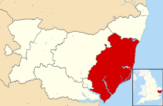
East Suffolk, along with West Suffolk, was created in 1888 as an administrative county of England. The administrative county was based on the eastern quarter sessions division of Suffolk. East Suffolk County Council's headquarters were at East Suffolk County Hall in Ipswich.

Wickham Market is a large village and electoral ward situated in the River Deben valley of Suffolk, England, within the Suffolk Coastal heritage area.

Walton is a settlement and former civil parish in the East Suffolk district, in the county of Suffolk, England, lying between the rivers Orwell and Deben. It is now part of Felixstowe parish. In 1911 the parish had a population of 4226.

Alderton is a village and civil parish in the East Suffolk district of Suffolk, England, about six miles north of Felixstowe, 10 miles south-east of Woodbridge and 2 miles south of Hollesley, on the North Sea coast and in the heart of the Suffolk Coast and Heaths Area of Outstanding Natural Beauty. In 2007 its population was 430, reducing to 423 at the 2011 Census.

Bromeswell is a village and civil parish in the East Suffolk district of Suffolk, England about 2 miles east of Woodbridge.
Eye was a parliamentary constituency, represented in the House of Commons of the Parliament of the United Kingdom, encompassing an area around the market town and civil parish of Eye, Suffolk.
Culpho is a hamlet and civil parish in the East Suffolk district of Suffolk, about 4 miles (6.4 km) northeast of the centre of Ipswich and 3+1⁄2 miles (5.6 km) west of Woodbridge.

Dallinghoo is a village about three miles (5 km) north of Woodbridge, Suffolk, England.

Butley is a village and civil parish in the English county of Suffolk.

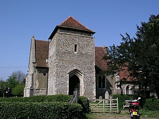
Great Bealings is a small village in Suffolk, England. It has about 302 people living in it in around 113 households. Its nearest towns are Ipswich and Woodbridge. Nearby villages include Little Bealings, Playford, Culpho, Hasketon and Grundisburgh. The village does not have an obvious centre, and the population is split between two areas — one around Lower Street to the East of the village, and the other at Boot Street/Grundisburgh Road to the West of the village. St Mary's, the village church, is about in the middle of these two centres of population.

Deben Rural District was a rural district in the county of East Suffolk, England. It was created in 1934 by the merger of parts of the disbanded Bosmere and Claydon Rural District, the disbanded Plomesgate Rural District and the disbanded Woodbridge Rural District, under a County Review Order. It was named after the River Deben and administered from Woodbridge.
Loes was a hundred of Suffolk, with an area of 31,321 acres (126.75 km2).

Shottisham is a village and civil parish in the East Suffolk district, in the county of Suffolk. It lies in the Wilford Hundred, about four and a half miles south-east of Woodbridge, between the parishes of Sutton, Alderton, Ramsholt and Hollesley, in the Bawdsey peninsula. About three miles from the coast at Hollesley Bay and Shingle Street, the village street overlooks a slight hollow of meads and copses at the road crossing of Shottisham Creek, a tributary brook of the river Deben.

Sutton is a village and a civil parish on the B1083 road, in the East Suffolk district, in the county of Suffolk, England. Sutton has a pub, a mobile post office and a place of worship. There is also the hamlet of Sutton Street and the Sutton Common estate nearby.

Woodbridge Rural District was a rural district within the administrative county of East Suffolk between 1894 and 1934. It was created out of the earlier Woodbridge rural sanitary district. It surrounded the town of Woodbridge, which had earlier been created as an urban district.