Woodbridge, Suffolk

Last updated

Woodbridge
Woodbridge1.jpeg
The harbour, with Woodbridge Tide Mill in the background
Woodbridge Achievement.png
Suffolk UK relief location map.jpg
Red pog.svg
Woodbridge
Location within Suffolk
United Kingdom relief location map.jpg
Red pog.svg
Woodbridge
Location within the United Kingdom
Coordinates: 52°05′38″N01°19′12″E / 52.09389°N 1.32000°E / 52.09389; 1.32000
Sovereign state United Kingdom
Constituent Country England
Region East Anglia
County Suffolk
Population
 (2011)
  Total7,749
  Estimate 
(2020)
8,244
 (2011 Census) [1]
Postcode
Area code 01394
Website www.eastsuffolk.gov.uk
Woodbridge Thoroughfare in July 2017 Cmglee Woodbridge Thoroughfare.jpg
Woodbridge Thoroughfare in July 2017

Woodbridge is a port town and civil parish in the East Suffolk district of Suffolk, England. It is 8 miles (13 km) up the River Deben from the sea. It lies 7 miles (11 km) north-east of Ipswich and around 74 miles north-east of London. [2]

Contents

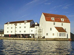
The town is close to some major archaeological sites of the Anglo-Saxon period, including the Sutton Hoo burial ship, and had 35 households at the time of the Domesday Book of 1086. It is well known for its boating harbour and tide mill next to the Deben River, on the edge of the Suffolk Coast and Heath Area of Outstanding Natural Beauty. [3] Several festivals are held. [4] As a "gem in Suffolk's crown", [5] it has been named the best place to live in the East of England. [6]

Etymology

Historians disagree over the etymology of Woodbridge. The Dictionary of British Placenames (2003) suggests that it is a combination of the Old English wudu (wood) and brycg (bridge). [7] The Sutton Hoo Society's 1988 magazine Saxon points out, however, that there is no suitable site for a bridge at Woodbridge, or any fordable sites until Wilford, the site of the current bridge, several miles upstream. [8] It also raises that an Anglo-Saxon bridge being wooden would have been unlikely to be worthy of comment. [8] It suggests that it might instead have been a combination of odde (a cognate of the Old Scandinavian oddi meaning promontory or cape) and breg (from the Anglo-Saxon brego meaning king - note the closeness of Sutton Hoo) or more likely bryg (a cognate of the Norwegian brygge or quay). [8]

The Suffolk Traveller (1764) suggests a similar origin to The Dictionary but originating from a bridge over a hollow way that leads from Woodbridge Market Place to the Ipswich. [9] But this is disputed by Rev. Thomas Carthew, then perpetual curate of Woodbridge who points out that the bridge had existed for less than a hundred years at that point and therefore was not old enough to be the source of the name. [10] He instead suggests Oden or Woden (Odin) and Burgh, Bury, or Brigg (town). [10] The Topographical Dictionary of England (1840) suggests a combination of Woden and Bryge. [11]

History and heritage

Archaeological finds point to habitation in the area from the Neolithic Age (2500–1700 BCE). A ritual site was found while excavations were made for the East Anglia Array, a wind farm at Seven Springs Field. [12] The area was occupied by the Romans for 300 years after Queen Boudica's failed rebellion in 59 CE, but there is little evidence of their presence.

After the Roman forces were recalled to Rome in 410 CE, substantial Anglo-Saxon (Germanic) settlement ensued. The Angles gave their name to East Anglia.

King Rædwald of East Anglia was Bretwalda, the most powerful king in England in the early 7th century. He died in about 624 CE and is often associated with the burial at Sutton Hoo, across the River Deben from Woodbridge. The burial ship is 89 feet (27 m) long. The treasures discovered there in 1939 were the richest finds ever on British soil. They are held now in the British Museum in London, but replicas of some items and the story of the finds can be seen in the Woodbridge Museum. The National Trust has built a visitor centre on the site.

The earliest record of Woodbridge as such dates from the mid-10th century, when it was acquired by St Aethelwold, Bishop of Winchester, as part of the endowment of a monastery he helped to refound at Ely, Cambridgeshire in 970. [13] The Domesday Book of 1086 describes Woodbridge as part of Loes Hundred with 35 households, i. e. one of the largest 20 per cent of settlements recorded. [14] Much of Woodbridge was granted to the powerful Bigod family, who built the castle at Framlingham.

The town has been a centre for boatbuilding, rope-making and sail-making since the Middle Ages. Edward III and Sir Francis Drake had fighting ships built in Woodbridge. [15] The town suffered in the plague of 1349, but recovered enough, with encouragement from the Canons and growing general prosperity, to have a new church (St Mary's, behind the buildings on the south side of Market Hill) built of limestone from the Wash and decorated with Thetford flint. By the mid-15th century the Brews family had added a tower and porch.

On 12 October 1534, Prior Henry Bassingbourne confirmed Henry VIII's supremacy over the Church and rejected the incumbent "Roman Bishop". Nonetheless, Woodbridge Priory was dissolved three years later. [16]

As religious unrest continued under the Roman Catholic Queen Mary Tudor, Alexander Gooch, a weaver of Woodbridge, and Alice Driver of Grundisburgh were burnt for heresy on Rushmere Heath. Alice had previously had her ears cut off for likening Queen Mary to Jezebel. Subsequent religious settlement under Elizabeth I helped Woodbridge industries such as weaving, sail-cloth manufacture, rope-making and salt making to prosper, along with the wool trade. The port was enlarged, and shipbuilding and the timber trade became lucrative, so that a customs house was established in 1589.

The town has various buildings of the Tudor, Georgian, Regency and Victorian periods, and a tide mill in working order, one of only two in the UK and among the earliest. The mill first recorded on the site in 1170 was run by Augustinian canons. In 1536 it passed to King Henry VIII. In 1564, Queen Elizabeth I granted the mill and the priory to Thomas Seckford, who in 1577 founded Woodbridge School and the Seckford Almshouses for the poor of Woodbridge. Two windmills survive, Buttrum's Mill, and Tricker's Mill, of which Buttrum's is open to the public. [17]

In 1943, the Royal Air Force (RAF) built a military airfield east of Woodbridge. RAF Woodbridge was used during the Cold War by the United States Air Force as the base for two Tactical Fighter Squadrons until 1993.

Governance

Woodbridge Shire Hall The Shire Hall, Woodbridge Market Hill (geograph 3595539).jpg
Woodbridge Shire Hall

Woodbridge lies in the East Suffolk district of the shire county of Suffolk. It is a civil parish; the town council, which is based at Woodbridge Shire Hall, was formed in 1974 as a third-tier successor to the urban district council and has a mayor and 16 councillors elected for four wards. [18] The town is currently represented by the Conservative Therese Coffey in the Suffolk Coastal parliamentary constituency. [19] The county councillor is the Liberal Democrat Caroline Page.

Education and the arts

The town has state and grant-aided primary and secondary education at Farlingaye High School, Woodbridge Primary School, Kyson Primary School, and St Mary's Church of England Voluntarily Aided Primary School. [20] The co-educational independent Woodbridge School has junior and senior departments and facilities for boarding. [21]

Woodbridge has a community brass band, the Excelsior, formed in 1846, which makes it the oldest in East Anglia. [22] There is a local radio station. [23] The town also has a two-hectare (5-acre) walled park. [24] Also of interest ecologically are the Quaker Burial Ground [25] and Fen Meadow, 2.67 hectares (6.6 acres) of traditionally managed grassland. [26]

Media

Local news and television programmes are provided by BBC East and ITV Anglia. Television signals are received from the Sudbury TV transmitter and the local relay transmitter. [27]

Local radio stations are BBC Radio Suffolk, Heart East, Greatest Hits Radio Ipswich & Suffolk, Nation Radio Suffolk and Ipswich Community Radio, a community based station which broadcast from nearby Ipswich. [28]

The town is served by the local newspaper, Ipswich Star.

Sport and leisure

Woodbridge Tide Mill Woodbridge Tide Mill (1).jpg
Woodbridge Tide Mill

Woodbridge has a Non-League football club Woodbridge Town F.C., which plays at Notcutts Park.

The many clubs and groups cover association football, badminton, birdwatching, bowls, cricket, cruising, netball, road running, rowing, rugby football, [29] swimming, tennis, golf (Woodbridge Golf Club, founded 1893 at Bromeswell listed in the top 100 in England and Ufford Park), yachting and archery. [30] They include Deben Rowing Club and Deben Yacht Club.

The town's Deben Leisure Centre and swimming pool were refurbished in 2017–2018 and now provide fuller services since reopening. [31]

Places of worship

St John's Church, Woodbridge St.John's Church, Woodbridge - geograph.org.uk - 1141298.jpg
St John's Church, Woodbridge

The two Church of England churches are the medieval St Mary's on Market Hill, [32] [33] and the Victorian St John's on St John's Hill. [34] [35]

St Mary's Church, Woodbridge Woodbridge - Church of St Mary (2).jpg
St Mary's Church, Woodbridge

Woodbridge Quay Church in Quay Street, once the Quay Meeting House, embodies a 2006 merger of the town's Baptist and United Reformed congregations. It is affiliated to the Baptist Union of Great Britain and the Evangelical Alliance. [36] There is a Methodist Church in St John's Street, a Salvation Army hall in New Street, [37] and the Roman Catholic Church of St Thomas of Canterbury in St John's Street. The last forms a joint parish with Framlingham. [38] Woodbridge Quaker Meeting meets weekly at Woodbridge Shire Hall. Avenue Evangelical Church, on the outskirts of Woodbridge, is affiliated to the Fellowship of Independent Evangelical Churches. [39]

Climate

Woodbridge has an unusually warm summer climate, according to the averages for 1991–2020, and is exceptionally dry by British standards. [40]

Climate data for RAF Bentwaters 26m amsl (1991–2020)
MonthJanFebMarAprMayJunJulAugSepOctNovDecYear
Mean daily maximum °C (°F)7.8
(46.0)
5.8
(42.4)
10.2
(50.4)
11.2
(52.2)
15.3
(59.5)
17.7
(63.9)
21.5
(70.7)
22.6
(72.7)
19.3
(66.7)
12.9
(55.2)
10.6
(51.1)
7.3
(45.1)
13.5
(56.3)
Daily mean °C (°F)6.0
(42.8)
4.0
(39.2)
7.7
(45.9)
8.3
(46.9)
12.2
(54.0)
14.4
(57.9)
18.4
(65.1)
19.1
(66.4)
15.9
(60.6)
10.5
(50.9)
8.3
(46.9)
5.4
(41.7)
10.9
(51.5)
Mean daily minimum °C (°F)4.1
(39.4)
2.2
(36.0)
5.2
(41.4)
5.3
(41.5)
9.1
(48.4)
11.1
(52.0)
15.4
(59.7)
15.5
(59.9)
12.5
(54.5)
8.0
(46.4)
6.1
(43.0)
3.4
(38.1)
8.2
(46.7)
Average rainfall mm (inches)43.7
(1.72)
46.4
(1.83)
36.9
(1.45)
39.4
(1.55)
48.0
(1.89)
45.8
(1.80)
23.1
(0.91)
15.2
(0.60)
61.3
(2.41)
20.1
(0.79)
65.5
(2.58)
38.3
(1.51)
483.7
(19.04)
Average rainy days (≥ 1.0 mm)8.68.49.38.66.810.65.45.05.510.113.58.3100.1
Source: Meteoclimat [41]

Notable residents

Writers Edward FitzGerald and Anne Knight were born in Woodbridge, and fellow writer Bernard Barton lived in the town in later life.

Other residents of note include musicians Nate James and Charlie Simpson; actors Brian Capron and Nicholas Pandolfi; painter Thomas Churchyard; Director-General of the BBC Ian Jacob; abolitionist John Clarkson; Roy Keane the football manager, and Thomas Seckford, official at the court of Queen Elizabeth I. The clockmaker John Calver lived in the town. [42] Musicians Brian Eno and Brinsley Schwarz were born there. [43] The world's most tattooed man, Tom Leppard, was born in the town. So were the actor Gavin Lee and the footballer Vernon Lewis.

Twin towns

Woodbridge has been twinned since 1973 with Mussidan, a town in the Dordogne in south-west France.

Freedom of the Town

The following people and military units have received the Freedom of the Town of Woodbridge.

Military Units

See also

Related Research Articles

<span class="mw-page-title-main">Suffolk</span> County of England

Suffolk is a ceremonial county in the East of England and East Anglia. It is bordered by Norfolk to the north, the North Sea to the east, Essex to the south, and Cambridgeshire to the west. Ipswich is the largest settlement and the county town.

<span class="mw-page-title-main">Ipswich</span> Town and borough in England

Ipswich is a port town and borough in the county of Suffolk, England. Ipswich is the county town of Suffolk and is the largest settlement in the county, followed by Lowestoft and Bury St Edmunds. It is situated in East Anglia. Ipswich is the second-largest population centre in East Anglia, Norwich being the largest. It is 67 miles (108 km) northeast of London. In 2011 it had a population of 144,957. The Ipswich built-up area is the fourth-largest in the East of England region and the 42nd-largest in England and Wales. It includes the towns and villages of Kesgrave, Woodbridge, Bramford and Martlesham Heath.

<span class="mw-page-title-main">Hadleigh, Suffolk</span> Human settlement in England

Hadleigh is an ancient market town and civil parish in the Babergh district of Suffolk, England. The town is situated next to the River Brett, between the larger towns of Sudbury and Ipswich. It had a population of 8,253 at the 2011 census. The headquarters of Babergh District Council were located in the town until 2017.

<span class="mw-page-title-main">Bury St Edmunds</span> Town in Suffolk, England

Bury St Edmunds, commonly referred to locally as Bury, is a historic market and cathedral town and civil parish in the West Suffolk district, in the county of Suffolk, England. The town is best known for Bury St Edmunds Abbey and St Edmundsbury Cathedral. Bury is the seat of the Diocese of St Edmundsbury and Ipswich of the Church of England, with the episcopal see at St Edmundsbury Cathedral. In 2011 it had a population of 45,000.

<span class="mw-page-title-main">Felixstowe</span> Human settlement in England

Felixstowe is a port town in Suffolk, England. The estimated population in 2017 was 24,521. The Port of Felixstowe is the largest container port in the United Kingdom. Felixstowe is approximately 72 miles (116 km) northeast of London. Enjoy the Victorian Gardens along the sea front in a 360° virtual tour here

<span class="mw-page-title-main">Thomas Seckford</span> Member of the Parliament of England

Thomas Seckford or Thomas Sakford Esquire (1515–1587) was a senior lawyer, a "man of business" at the court of Queen Elizabeth I, a landowner of the armigerous Suffolk gentry, Member of Parliament, and public benefactor of the town of Woodbridge. He was one of the Masters in Ordinary of the Court of Requests to Queen Elizabeth, 1569-1587, and was Surveyor of the Court of Wards and Liveries 1581-1587. He built mansions in Woodbridge, Ipswich and Clerkenwell, and was at different times Steward of the Liberty of Ely in Suffolk, Bailiff for the Crown of the former possessions of Clerkenwell Priory in the City of London and County of Middlesex, and deputy Steward for the northern parts of the Duchy of Lancaster. He was the patron of Christopher Saxton in the making of the first surveyed County Atlas of England and Wales.

<span class="mw-page-title-main">Suffolk Coastal (UK Parliament constituency)</span> Parliamentary constituency in the United Kingdom, 1983 onwards

Suffolk Coastal is a parliamentary constituency in the county of Suffolk, England which has been represented in the House of Commons of the UK Parliament since 2010 by Thérèse Coffey, a Conservative Member of Parliament. She served as Secretary of State for Environment, Food and Rural Affairs from October 2022 to November 2023

<span class="mw-page-title-main">Wuffingas</span> Anglo-Saxon royal dynasty of East Anglia

The Wuffingas, Uffingas or Wiffings were the ruling dynasty of East Anglia, the long-lived Anglo-Saxon kingdom which today includes the English counties of Norfolk and Suffolk. The Wuffingas took their name from Wuffa, an early East Anglian king. Nothing is known of the members of the dynasty before Rædwald, who ruled from about 599 to c.624. The Viking invasions of the 9th century and Dissolution of the monasteries in the 16th century both led to the destruction of documents relating to the rule of the Wuffingas.

<span class="mw-page-title-main">Wickham Market</span> Human settlement in England

Wickham Market is a large village and electoral ward in the River Deben valley, Suffolk, England, within the Suffolk Coastal heritage area.

<span class="mw-page-title-main">Melton railway station (Suffolk)</span> Railway station in Suffolk, England

Melton railway station is on the East Suffolk Line in the east of England, serving the village of Melton, Suffolk. It is 11 miles 49 chains (18.7 km) down the line from Ipswich and 80 miles 28 chains (129.3 km) measured from London Liverpool Street; it is situated between Woodbridge and Wickham Market. Its three-letter station code is MES.

<span class="mw-page-title-main">Walton, Suffolk</span> Human settlement in England

Walton is a settlement and former civil parish, now in the parish of Felixstowe, in the East Suffolk district, in the county of Suffolk, England, lying between the rivers Orwell and Deben.

<span class="mw-page-title-main">Felix of Burgundy</span> 7th-century Bishop of Dunwich and saint

Felix of Burgundy, also known as Felix of Dunwich, was the first bishop of the kingdom of the East Angles. He is widely credited as the man who introduced Christianity to the kingdom. Almost all that is known about him comes from the Ecclesiastical History of the English People, completed by the English historian Bede in about 731, and the Anglo-Saxon Chronicle. Bede wrote that Felix freed "the whole of this kingdom from long-standing evil and unhappiness".

<span class="mw-page-title-main">Dommoc</span>

Dommoc, a place not certainly identified but probably within the modern county of Suffolk, was the original seat of the Anglo-Saxon bishops of the Kingdom of East Anglia. It was established by Sigeberht of East Anglia for Saint Felix in c. 629–631. It remained the bishopric of all East Anglia until c. 673, when Theodore of Tarsus, Archbishop of Canterbury, divided the see and created a second bishopric at either North Elmham, Norfolk, or South Elmham, Suffolk. The see of Dommoc continued to exist until the time of the Viking Wars of the 860s, after which it lapsed.

<span class="mw-page-title-main">Great Bealings</span> Human settlement in England

Great Bealings is a small village in Suffolk, England. It has about 302 people living in it in around 113 households. Its nearest towns are Ipswich and Woodbridge. Nearby villages include Little Bealings, Playford, Culpho, Hasketon and Grundisburgh. The village does not have an obvious centre, and the population is split between two areas — one around Lower Street to the East of the village, and the other at Boot Street/Grundisburgh Road to the West of the village. St Mary's, the village church, is about in the middle of these two centres of population.

<span class="mw-page-title-main">Port of Ipswich</span> Major port in Suffolk, England

The Port of Ipswich can be dated to c.625. The name Ipswich was originally Gippeswyc, referring to the River Gyppes with a suffix derived from the Scandinavian term vik, which had evolved from meaning bay or inlet to mean landing-place, following the proliferation of merchants requiring places to unload their goods and conduct trade. Since 1997 the port has been run by Associated British Ports.

<span class="mw-page-title-main">Ipswich Waterfront</span>

The Ipswich Waterfront is a cultural and historically significant area surrounding the marina in the town of Ipswich, Suffolk, England. The modern dock was constructed in 1842 and the area was a functioning dock up until the 1970s. At the time of completion, the dock was known as 'the biggest and most important enclosed dock in the kingdom'. Although the dock as it stands was constructed in 1842, the area was used for trade as far back as the 7th century. The decline of industry in the town resulted in the area being transformed into a trendy area of Ipswich, the waterfront is now characterised by its marina, known as Neptune Marina, as well as its mix of classical and postmodern architecture which includes multiple high-rise apartment buildings, restaurants, bars and cafés. The waterfront is also home to the main campus of the region's university, the University of Suffolk.

<span class="mw-page-title-main">Waldringfield</span> Human settlement in England

Waldringfield is a village and civil parish in the East Suffolk district, in the county of Suffolk, England. It is situated on the bank of the River Deben within the Suffolk Coast and Heaths Area of Outstanding Natural Beauty, 4 miles (6.4 km) south of the town of Woodbridge and 8 miles (12.9 km) east of the county town of Ipswich.

Sutton is a village and a civil parish on the B1083 road, in the East Suffolk district, in the county of Suffolk, England. Sutton has a pub, a mobile post office and a place of worship. There is also the hamlet of Sutton Street and the Sutton Common estate nearby.

Vincent Burrough Redstone was a Suffolk historian who suggested to Edith Pretty that the Sutton Hoo Ship-burial should be excavated. He was a master of Woodbridge School and secretary of the Suffolk Institute of Archaeology. He retired from Woodbridge School in 1921 and spent the remainder of his life researching historical topics. He was particularly noted for his study of Huguenot settlement in Suffolk.

References

  1. "Population - Ward Woodbridge". Suffolk Observatory. Retrieved 14 September 2015.
  2. "Distance from Woodbridge Suffolk Great Britain to London City Great Britain". Distantias. Retrieved 22 August 2023.
  3. "Home". www.suffolkcoastandheaths.org. Retrieved 14 December 2020.
  4. Venning, Nicola (4 June 2018). "The best locations for culture vultures: live near Britain's best arts festivals". The Telegraph. ISSN   0307-1235 . Retrieved 14 December 2020.
  5. "Guide to Woodbridge - a historic, riverside town in Suffolk". www.thesuffolkcoast.co.uk. Retrieved 14 December 2020.
  6. "Suffolk town named best place to live in the East". ITV News. 17 March 2017. Retrieved 14 December 2020.
  7. Mills, A. D. (2003). A dictionary of British place-names. A. D. Mills. Oxford: Oxford University Press. ISBN   978-0-19-173944-6. OCLC   54381298.
  8. 1 2 3 "Where is the bridge at Woodbridge" (PDF). Saxon. No. 7. Spring 1988.
  9. Kirby, John (1764). The Suffolk Traveller. J. Shave and sold. p. 106.
  10. 1 2 "Notes from a copy of the Suffolk Traveler". British Isle Geanology. Retrieved 5 May 2021.
  11. Lewis, Samuel (1840). "Woodbridge". A Topographical Dictionary of England. Vol. 4. S. Lewis and Company. p. 581.
  12. Kennedy, Maev (28 June 2018). "Archaeologists stumble on Neolithic ritual site in Suffolk". The Guardian. Retrieved 28 June 2018.
  13. British History online. Retrieved 27 December 2019.
  14. "Woodbridge". opendomesday.org. Open Domesday. Retrieved 6 December 2021.
  15. Long, Peter (2004). The Hidden Places of England. Traveller Publishing Ltd. p. 514. ISBN   1904434126.
  16. The Abbey (Junior School), Woodbridge, British Listed Buildings. Retrieved 1 May 2011.
  17. English Heritage descriptions. Retrieved 20 December 2010.
  18. "About Woodbridge Town Council". Suffolk County Council. Retrieved 21 December 2010.
  19. "Election 2010: Results:UK>England>Eastern>Suffolk Coastal". BBC . Retrieved 21 December 2010.
  20. "A to Z of schools by village/town". Suffolk County Council . Retrieved 21 December 2010.
  21. "Retrieved 20 December 2010". woodbridge.suffolk.sch.uk.
  22. "Home". Home.
  23. "Community Radio for Woodbridge & The Deben Valley. Retrieved 20 December 2010". debenradio.co.uk.
  24. "Retrieved 20 December 2010". onesuffolk.co.uk.
  25. "Retrieved 20 December 2010". onesuffolk.co.uk.
  26. "Retrieved 12 December 2010". onesuffolk.co.uk.
  27. "Freeview Light on the Woodbridge (Suffolk, England) transmitter". UK Free TV. 1 May 2004. Retrieved 12 December 2023.
  28. "Ipswich Community Radio" . Retrieved 12 December 2023.
  29. "Home – Woodbridge Rugby Club". Woodbridge Rugby Club.
  30. "Retrieved 20 December 2010". onesuffolk.co.uk.
  31. "Suffolk Coastal's Leisure Centre Redevelopment Programme » East Suffolk". www.eastsuffolk.gov.uk. Retrieved 12 March 2019.
  32. Knott, Simon (July 2019). "St Mary, Woodbridge". Suffolk Churches. Retrieved 6 January 2022.
  33. "Home". St. Mary's Church. Retrieved 6 January 2022.
  34. Knott, Simon (December 2017). "St John, Woodbridge". Suffolk Churches. Retrieved 6 January 2022.
  35. "Homepage". St John's Woodbridge. Retrieved 6 January 2022.
  36. webmaster@thequay.org.uk, Michael Astbury-. "Woodbridge Quay Church". www.thequay.org.uk.
  37. "Retrieved 20 December 2010". woodbridgesalvationarmy.org.uk.
  38. Community: Retrieved 20 December 2010. Architecture: Retrieved 20 December 2010.
  39. "Avenue Evangelical Church – A Christ-centred, Bible-teaching, Evangelical church in Woodbridge". www.avenueevangelicalchurch.org.uk. Retrieved 4 November 2016.
  40. "Météo climat stats | Moyennes 1991/2020 / Données Météorologiques Gratuites". climate-datas-weather.dynalias.org.
  41. "Bentwaters Climate Period: 1991–2020". Meteoclimat. Retrieved 27 January 2021.
  42. Garfield, Simon (19 October 2016). "Still ticking: The improbable survival of the luxury watch business | Simon Garfield". The Guardian. ISSN   0261-3077 . Retrieved 5 July 2018.
  43. Miller, Andy (5 July 2008). "The life and times of Brian Eno". The Daily Telegraph . Retrieved 21 December 2010.
  44. "23 Engineer Regiment exercises freedom of Woodbridge". BBC News Suffolk. 19 May 2011. Retrieved 24 August 2022.
  45. Potter, Tom (23 July 2015). "Parade celebrates links between Woodbridge and 23 Parachute Engineer Regiment".
  46. Potter, Tom (26 April 2016). "Freedom honour for RBL branch solidifies town's military links". The East Anglian Daily Times. Retrieved 16 September 2021.