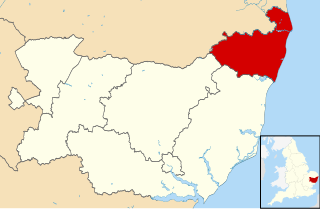
Waveney was a local government district in Suffolk, England, named after the River Waveney that formed its north-east border. The district council was based in Lowestoft, the major settlement in Waveney. The other towns in the district were Beccles, Bungay, Halesworth and Southwold.
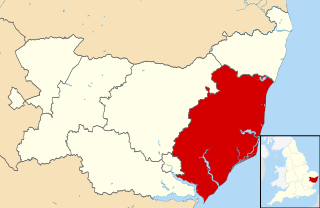
Suffolk Coastal was a local government district in Suffolk, England. Its council was based in Melton, having moved from neighbouring Woodbridge in 2017. Other towns include Felixstowe, Framlingham, Leiston, Aldeburgh, and Saxmundham.

Rickinghall Superior is a civil parish in the Mid Suffolk district of Suffolk, England. It covers the eastern part of the village of Rickinghall, and also the hamlets of Candle Street and Allwood Green. The population of this civil parish at the 2011 census was 719.

Kelsale is a village and former civil parish, now in the parish of Kelsale cum Carlton, in the East Suffolk district, in the county of Suffolk, England. It is located approximately 1 mile north of Saxmundham town centre at the junction of the B1121 and the A12. In 1881 the civil parish had a population of 973.

Carlton is a village and former civil parish, now in the parish of Kelsale cum Carlton, in the Suffolk Coastal district, in the county of Suffolk, England. It is located one mile north of Saxmundham. The village is bordered by Kelsale in the north, the B1121 in the east and the A12 to the west. In 1881 the civil parish had a population of 94.

Wenhaston with Mells Hamlet is a civil parish in the English county of Suffolk. The population at the 2011 Census was 801. It forms part of East Suffolk district and is situated just south of the River Blyth.
Copdock and Washbrook is a civil parish in the Babergh district, in the county of Suffolk, England. It covers the villages of Copdock and Washbrook, as well as the hamlets of Coles Green, Mace Green and Washbrook Street.

Wenham Parva is a village and a civil parish in Suffolk, England. It covers the village of Little Wenham and the hamlet of Wenham Grange. Located in Babergh district, it had a population of 20 in 2005, making it the joint-least populated parish in Suffolk alongside South Cove, Wangford and Wordwell. At the 2011 Census the population had increased to 185.
Old Newton with Dagworth is a civil parish in the Mid Suffolk district of Suffolk in eastern England. The parish contains the village of Old Newton, as well as the hamlets of Brown Street, Dagworth and Ward Green. In 2005 its population was 1,050. The parish shares a parish council with neighbouring Gipping.

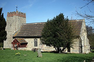
Skoulding's Mill is a Grade II listed tower mill at Kelsale, Suffolk, England which has been converted to residential accommodation.

Weston Colville is a village in South Cambridgeshire, 10 miles southeast of Cambridge and 6 miles south of Newmarket, close to the border with Suffolk.
Hoxne was a hundred of Suffolk, with an area of 55,648 acres (225.20 km2).

Saxtead is a small village in the East Suffolk district, in the county of Suffolk. Saxtead gives its name to the settlements of Saxtead Green and Saxtead Little Green and the windmill Saxtead Green Windmill. The population of the civil parish at the 2011 Census was 335. Saxtead is located on the A1120 road in between the town of Stowmarket and the village of Yoxford.

Cransford is a village and a civil parish in the East Suffolk district, in the English county of Suffolk. The civil parish had a population at the 2011 Census of 162.

Monewden is a small village and a civil parish in the hundred of Loss, in the Suffolk Coastal District, in the English county of Suffolk. The population of the civil parish as of the 2011 census was 120. The village is located around 12 miles (19 km) north of Ipswich and 4 miles (6.4 km) west of Wickham Market.

Hemley is a village and a civil parish in the East Suffolk district, in the English county of Suffolk.

Falkenham is a village and a civil parish in the East Suffolk district, in the English county of Suffolk, near the village of Kirton and the towns of Ipswich and Felixstowe. The population of the civil parish as of the 2011 census was 170.

Peasenhall is a village and civil parish in the East Suffolk district, in the English county of Suffolk. The population of the civil parish at the 2011 Census was 517. It lies on the A1120 tourist route; neighbouring villages include Sibton and Yoxford. It was the location of the Peasenhall Murder.
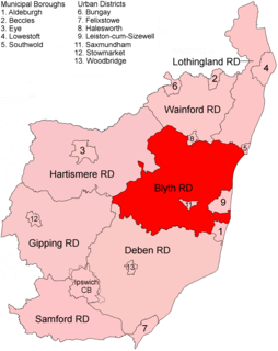
Blyth Rural District was a rural district in East Suffolk, England, between 1934 and 1974.

Oulton or Oldton is a suburb of Lowestoft and civil parish 38 miles (61 km) north east of Ipswich, in the East Suffolk district, in the county of Suffolk, England. In 2011 the parish had a population of 4060. The parish touches Blundeston, Burgh St Peter, Carlton Colville, Corton, Flixton, Lowestoft and Oulton Broad. Oulton is in the UK Parliamentary Constituency of Waveney.

