Related Research Articles

Framlingham is a market town and civil parish in Suffolk, England. Of Anglo-Saxon origin, it appears in the 1086 Domesday Book. The parish had a population of 3,342 at the 2011 Census and an estimated 4,016 in 2019. Nearby villages include Earl Soham, Kettleburgh, Parham, Saxtead and Sweffling.

Corton is a village and civil parish in the north of the English county of Suffolk. It is 3 miles (4.8 km) north of the centre of Lowestoft in the East Suffolk district. The village is on the North Sea coast with the county border with Norfolk to the north. It is a seaside holiday centre, with a number of facilities for visitors. Great Yarmouth is 6 miles (9.7 km) to the north.

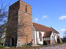
Baylham is a village and civil parish in the Mid Suffolk district of Suffolk, England, about 7 miles (11 km) northwest of Ipswich and 6 miles (9.7 km) southeast of Stowmarket. The buildings making up the village begin either side of the B113 road, with the majority following Upper Street and northwards along Church Lane, close to the church, to Glebe Close.

Blundeston is a village and civil parish in the north of the English county of Suffolk. It is 3.5 miles (5.6 km) north-west of Lowestoft, 6 miles (9.7 km) south of Great Yarmouth and around 1.75 miles (2.82 km) inland from the North Sea coast. It is part of the area known as Lothingland in the East Suffolk district. Blundeston Prison was located on the southern edge of the village but closed in early 2014.

Nacton is a village and civil parish in the East Suffolk district of Suffolk, England. The parish is bounded by the neighbouring parishes of Levington to the east and Bucklesham in the north. It is located between the towns of Ipswich and Felixstowe.

Ovington is a small village in north Essex, England. The village is situated about three miles (5 km) from the village of Clare. It consists of St. Mary's Church, and a few houses. There is the air traffic of Ridgewell Airfield. The population of the village is included in the civil parish of Tilbury Juxta Clare.

Wissett is a village and civil parish in the English county of Suffolk. It is 2 miles (3.2 km) north-east of the market town of Halesworth in the East Suffolk district. Historically, it was in the Blything Hundred.

Sotterley, originally Southern-lea from its situation south of the river, is a village and civil parish in the East Suffolk district, in the English county of Suffolk, located approximately 4 miles (6 km) south-east of Beccles and 1.5 miles (2 km) east of Willingham St Mary and Shadingfield. The parish is primarily agricultural with a dispersed population of 113 at the 2011 census. The parish council operates to administer jointly the parishes of Shadingfield, Willingham St Mary, Sotterley and Ellough.

Newton Flotman, a village and civil parish in the English county of Norfolk, lies about 8 miles south of Norwich on the A140 road between Tasburgh and Swainsthorpe. The River Tas flows through. The area of 4.87 km2 (1.88 sq mi) had 1,197 inhabitants in 497 households at the 2001 census, increasing to 1,489 at the 2011 census. For local government it lies in the district of South Norfolk. The name means "new farm/settlement". The de Ferers family held land there in the 13th century.

Cockfield is a village and civil parish located approximately 3+1⁄2 miles (5.6 km) from Lavenham in Suffolk, England. The village consists of a central point and several outlying hamlets: Buttons Green, Colchester Green, Cross Green, Great Green, Oldhall Green, Smithwood Green and Windsor Green. Surrounded mostly by fields used for farming, and with few roads, its population was 839 in 2001, increasing to 868 at the 2011 Census.

Farnham is a village and civil parish about 3 miles (4.8 km) south-west of Saxmundham in the English county of Suffolk on the A12 road. Farnham is located west of Friday Street, south of Benhall Low Street and north-east of Stratford St Andrew.
Trimley St. Martin is a parish and village that lies between the rivers Orwell and the Deben, on the long narrow tongue of land from Ipswich to Felixstowe referred to as the Colneis Hundred.

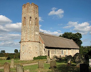
Wortham is a village and parish in Suffolk, England, close to the border with Norfolk. Its church, St Mary the Virgin, lies about a mile north of the present-day village. It is one of 38 existing round-tower churches in Suffolk and the one with the greatest diameter in England.
Haughley is a village and civil parish in the English county of Suffolk, about two miles from Stowmarket in the Mid Suffolk District. The village is located 2 miles (3.2 km) miles northwest of the town of Stowmarket, overlooking the Gipping valley, next to the A14 corridor. The population recorded in 2011 was 1,638. Mentioned in the Domesday Book, it was the site of a castle, a church on the pilgrim's route to Bury St Edmunds Abbey, and a market. Adjacent farms on the north side of the village were also home to one of the first studies of organic farming and the first headquarters of the Soil Association.

Earl Soham is a small settlement in Suffolk, England. It is on the A1120 road and is 4 kilometres (2 mi) west of the town of Framlingham.
Ashby is a former civil parish in the north of the English county of Suffolk. It is 5+1⁄2 miles (8.9 km) north-west of Lowestoft in the East Suffolk district. The parish was combined with Somerleyton and Herringfleet to form the combined parish of Somerleyton, Ashby and Herringfleet in 1987.

Lidgate is a small village and a civil parish in the West Suffolk district, in the English county of Suffolk. Lidgate is located on the B1063 road in between the towns of Newmarket and Clare. The population of Lidgate is around 250, measured at 241 in the 2011 Census.

Falkenham is a village and a civil parish in the East Suffolk district, in the English county of Suffolk, near the village of Kirton and the towns of Ipswich and Felixstowe. The population of the civil parish as of the 2011 census was 170.

Rumburgh Priory was a Benedictine priory located in the village of Rumburgh in the English county of Suffolk. The priory was founded in about 1065 as a cell of St Benet's Abbey at Hulme in Norfolk. At the time of the Domesday Book in 1086 it had 12 monks. The ownership of the priory was transferred to St Mary's Abbey in York towards the end of the 12th century. The monks of Rumburgh were particularly devoted to St. Bee, whom they commemorated at Michaelmas.
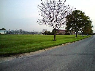
The Levington Research Station is a fertiliser research institute in Suffolk.
References
- ↑ "Parish population 2011" . Retrieved 16 September 2015.
Coordinates: 52°00′N1°15′E / 52.000°N 1.250°E
| Boroughs or districts | |
|---|---|
| Major settlements | |
| Topics | |
| | This Suffolk location article is a stub. You can help Wikipedia by expanding it. |