Deenwood, Georgia

Last updated
Deenwood, Georgia
Ware County Georgia Incorporated and Unincorporated areas Deenwood Highlighted.svg
Location in Ware County and the state of Georgia
Coordinates: 31°14′20″N82°22′18″W / 31.23889°N 82.37167°W / 31.23889; -82.37167
Country United States
State Georgia
County Ware
Area
[1]
  Total3.39 sq mi (8.77 km2)
  Land3.35 sq mi (8.69 km2)
  Water0.03 sq mi (0.09 km2)
Elevation
135 ft (41 m)
Population
 (2020)
  Total2,207
  Density658.02/sq mi (254.09/km2)
Time zone UTC-5 (Eastern (EST))
  Summer (DST) UTC-4 (EDT)
FIPS code 13-22080 [2]
GNIS feature ID0357663 [3]

Deenwood is an unincorporated community and census-designated place (CDP) in Ware County, Georgia, United States. The population was 2,207 at the 2020 census. It is part of the Waycross micropolitan statistical area. Deenwood Baptist Church is named after this geographical area.

Contents

Geography

Deenwood is located at 31°14′20″N82°22′18″W / 31.23889°N 82.37167°W / 31.23889; -82.37167 (31.238993, -82.371540). [4]

According to the United States Census Bureau, the CDP has a total area of 3.4 square miles (8.8 km2), all land.

Climate

The climate in this area is characterized by relatively high temperatures and evenly distributed precipitation throughout the year. According to the Köppen Climate Classification system, Deenwood has a humid subtropical climate, abbreviated "Cfa" on climate maps. [5]

Climate data for Deenwood, Georgia
MonthJanFebMarAprMayJunJulAugSepOctNovDecYear
Mean daily maximum °C (°F)16
(60)
19
(66)
22
(71)
26
(78)
29
(84)
32
(89)
33
(91)
32
(89)
30
(86)
26
(78)
22
(71)
17
(62)
25
(77)
Mean daily minimum °C (°F)4
(39)
6
(42)
9
(48)
12
(53)
16
(60)
20
(68)
21
(69)
21
(69)
19
(66)
14
(57)
9
(48)
5
(41)
13
(55)
Average precipitation mm (inches)130
(5.1)
97
(3.8)
110
(4.5)
48
(1.9)
56
(2.2)
130
(5.2)
140
(5.7)
180
(7.1)
110
(4.2)
89
(3.5)
76
(3)
74
(2.9)
1,250
(49.2)
Source: Weatherbase [6]

Demographics

Historical population
CensusPop.Note
1950 1,113
1960 2,758147.8%
1970 3,0159.3%
1980 3,58018.7%
1990 2,055−42.6%
2000 1,836−10.7%
2010 2,14616.9%
2020 2,2072.8%
U.S. Decennial Census [7]
1850-1870 [8] 1870-1880 [9]
1890-1910 [10] 1920-1930 [11]
1940 [12] 1950 [13] 1960 [14]
1970 [15] 1980 [16] 1990 [17]
2000 [18] 2010 [19] 2020 [20]
1950 and 1960 as Hebardville

In the 1950 U.S. Census and 1960 U.S. Census, the census recognized the unincorporated place of Hebardville which was roughly coterminous with Deenwood. [13] [14] In the 1970 U.S. Census, the unincorporated community was renamed Deenwood and designated a CDP in 1980 U.S. Census. [16]

2020

Deenwood, Georgia – Racial and ethnic composition
Note: the US Census treats Hispanic/Latino as an ethnic category. This table excludes Latinos from the racial categories and assigns them to a separate category. Hispanics/Latinos may be of any race.
Race / Ethnicity (NH = Non-Hispanic)Pop 2000 [21] Pop 2010 [19] Pop 2020 [20] % 2000% 2010% 2020
White alone (NH)1,6721,7351,60591.07%80.85%72.72%
Black or African American alone (NH)1343094057.30%14.40%18.35%
Native American or Alaska Native alone (NH)0430.00%0.19%0.14%
Asian alone (NH)1026300.54%1.21%1.36%
Pacific Islander alone (NH)2000.11%0.00%0.00%
Some Other Race alone (NH)20130.11%0.00%0.59%
Mixed race or Multiracial (NH)339720.16%1.82%3.26%
Hispanic or Latino (any race)1333790.71%1.54%3.58%
Total1,8362,1462,207100.00%100.00%100.00%

In 1990, the population was 2,055. [22] At the 2020 census, its population grew to 2,207.

Related Research Articles

<span class="mw-page-title-main">Leisure City, Florida</span> Census-designated place in Florida

Leisure City is an unincorporated community and census-designated place (CDP) in Miami-Dade County, Florida, United States, that includes the smaller, older community of Modello in its northwestern section. The CDP is most notable for the Coral Castle Museum, located in the Modello area. It is located in the Miami metropolitan area of South Florida. The population was 26,324 at the 2020 census, up from 22,655 in 2010.

<span class="mw-page-title-main">Hardwick, Baldwin County, Georgia</span> Place in Georgia, United States

Hardwick is an unincorporated community and census-designated place (CDP) in Baldwin County, Georgia, United States. The population was 3,513 at the 2020 census, down from 5,135 in 2000, at which time it was listed as Midway-Hardwick. It is laid out around Central State Hospital. It is part of the Milledgeville Micropolitan Statistical Area. The zip code for Hardwick is 31034. Hardwick was home to Oglethorpe University during the 19th century.

<span class="mw-page-title-main">Lakeview, Georgia</span> Place in Georgia, United States

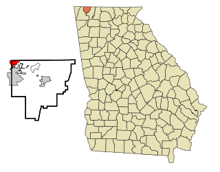
Lakeview is an unincorporated community and census-designated place (CDP) in Catoosa and Walker counties in the U.S. state of Georgia. The population was 4,820 at the 2000 census and 4,777 at the 2020 census. It is part of the Chattanooga, TN–GA Metropolitan Statistical Area.

<span class="mw-page-title-main">Montgomery, Georgia</span> Place in Georgia, United States

Montgomery is an unincorporated community and census-designated place (CDP) in Chatham County, Georgia, United States. The population was 4,443 at the 2020 United States census, down slightly from 4,523 in 2010. It is a suburb of Savannah and is part of the Savannah metropolitan area.

<span class="mw-page-title-main">Skidaway Island, Georgia</span> Place in Georgia, United States

Skidaway Island is an unincorporated community and census-designated place (CDP) in Chatham County, Georgia, and lies on a barrier island of the same name. Located south of Savannah, Skidaway Island is known for its waterfront properties and golf courses within The Landings, one of the largest gated communities in the country. The population was 9,310 at the 2020 census. For statistical purposes, the United States Census Bureau has defined Skidaway Island as a census-designated place (CDP). A separate area of the island hosts the Skidaway Institute of Oceanography, a research institution operated by the University of Georgia. It receives scholars and researchers from several other Georgia universities as well, including Georgia Tech, Savannah State University, and the College of Coastal Georgia. Skidaway Island is part of the Savannah Metropolitan Statistical Area.

<span class="mw-page-title-main">Martinez, Georgia</span> Place in Georgia, United States

Martinez is an unincorporated community and census-designated place (CDP) in Columbia County, Georgia, United States. It is a northwestern suburb of Augusta and is part of the Augusta, Georgia metropolitan area. The population was 34,535 at the 2020 census.

<span class="mw-page-title-main">Gresham Park, Georgia</span> Place in Georgia, United States

Gresham Park is an unincorporated community and census-designated place (CDP) in DeKalb County, Georgia, United States. The population was 7,700 at the 2020 census.

<span class="mw-page-title-main">Lindale, Georgia</span> Place in Georgia, United States

Lindale is an unincorporated community and census-designated place (CDP) in Floyd County, Georgia, United States. It is part of the Rome, Georgia Metropolitan Statistical Area. The population was 4,191 at the 2010 census.

<span class="mw-page-title-main">Country Club Estates, Georgia</span> Place in Georgia, United States

Country Club Estates is an unincorporated community and census-designated place (CDP) in Glynn County, Georgia, United States. It is part of the Brunswick metropolitan statistical area. The population was 8,373 at the 2020 census, down from 8,545 in 2010.

<span class="mw-page-title-main">Mountain Park, Gwinnett County, Georgia</span> Place in Georgia, United States

Mountain Park is an unincorporated community and census-designated place (CDP) in Gwinnett County, Georgia, United States. The population was 11,554 at the 2010 census. The older name for the area is Trickum, which is reflected in Five Forks-Trickum Road which bisects the community. The older community was centered on Five Forks and Rockbridge Roads.

<span class="mw-page-title-main">Hiltonia, Georgia</span> City in Georgia, United States

Hiltonia is a city in Screven County, Georgia, United States. The population was 310 in 2020.

<span class="mw-page-title-main">East Griffin, Georgia</span> Place in Georgia, United States

East Griffin is an unincorporated community and census-designated place (CDP) in Spalding County, Georgia, United States. The population was 1,635 at the 2000 census.

<span class="mw-page-title-main">Experiment, Georgia</span> Place in Georgia, United States

Experiment is an unincorporated community and census-designated place (CDP) in Spalding County, Georgia, United States. The population was 3,233 at the 2000 census.

<span class="mw-page-title-main">Phillipsburg, Georgia</span> Place in Georgia, United States

Phillipsburg is an unincorporated community and census-designated place (CDP) in Tift County, Georgia, United States. The population was 887 at the 2000 census.

<span class="mw-page-title-main">Hannahs Mill, Georgia</span> Place in Georgia, United States

Hannahs Mill is an unincorporated community and census-designated place (CDP) in Upson County, Georgia, United States. The population was 3,267 at the 2000 census.

<span class="mw-page-title-main">Lincoln Park, Georgia</span> Place in Georgia, United States

Lincoln Park is an unincorporated community and census-designated place (CDP) in Upson County, Georgia, United States. The population was 1,122 at the 2000 census.

<span class="mw-page-title-main">Sunnyside, Georgia</span> Place in Georgia, United States

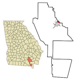
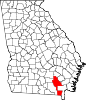
Sunnyside is an unincorporated community and census-designated place (CDP) in Ware County, Georgia, United States. The population was 1,472 in 2020. It is part of the Waycross micropolitan statistical area.

Epworth is an unincorporated community and census-designated place (CDP) in Fannin County, Georgia, United States. As of the 2010 census it had a population of 480. It lies at an elevation of 1,703 feet (519 m) in the north-central part of the county. A former name was Atalla. The ZIP code is 30541.

Empire is an unincorporated community and census-designated place in Dodge and Bleckley counties in the U.S. state of Georgia. As of the 2020 census, the CDP had a population of 319.

Norristown is an unincorporated community and census-designated place (CDP) in Emanuel County, Georgia, United States. Its population was 54 as of the 2020 census.

References

  1. "2020 U.S. Gazetteer Files". United States Census Bureau. Retrieved December 18, 2021.
  2. "U.S. Census website". United States Census Bureau . Retrieved 2008-01-31.
  3. "US Board on Geographic Names". United States Geological Survey. 2007-10-25. Retrieved 2008-01-31.
  4. "US Gazetteer files: 2010, 2000, and 1990". United States Census Bureau. 2011-02-12. Retrieved 2011-04-23.
  5. Climate Summary for Deenwood, Georgia
  6. "Weatherbase.com". Weatherbase. 2013. Retrieved on September 28, 2013.
  7. "Decennial Census of Population and Housing by Decade". United States Census Bureau.
  8. "1870 Census of Population - Georgia - Population of Civil Divisions less than Counties" (PDF). United States Census Bureau. 1870.
  9. "1880 Census of Population - Georgia - Population of Civil Divisions less than Counties" (PDF). United States Census Bureau. 1880.
  10. "1910 Census of Population - Georgia" (PDF). United States Census Bureau. 1930.
  11. "1930 Census of Population - Georgia" (PDF). United States Census Bureau. 1930. pp. 251–256.
  12. "1940 Census of Population - Georgia" (PDF). United States Census Bureau. 1940.
  13. 1 2 "1950 Census of Population - Georgia" (PDF). United States Census Bureau. 1980.
  14. 1 2 "1960 Census of Population - Population of County Subdivisions - Georgia" (PDF). United States Census Bureau. 1960.
  15. "1970 Census of Population - Population of County Subdivisions - Georgia" (PDF). United States Census Bureau. 1970.
  16. 1 2 "1980 Census of Population - Number of Inhabitants - Georgia" (PDF). United States Census Bureau. 1980.
  17. "1990 Census of Population - Summary Social, Economic, and Housing Characteristics - Georgia" (PDF). United States Census Bureau. 1990.
  18. "2000 Census of Population - General Population Characteristics - Georgia" (PDF). United States Census Bureau. 2000.
  19. 1 2 "P2: Hispanic or Latino, and Not Hispanic or Latino by Race – 2010: DEC Redistricting Data (PL 94-171) – Deenwood CDP, Georgia". United States Census Bureau.
  20. 1 2 "P2: Hispanic or Latino, and Not Hispanic or Latino by Race – 2020: DEC Redistricting Data (PL 94-171) – Deenwood CDP, Georgia". United States Census Bureau.
  21. "P004 Hispanic or Latino, and Not Hispanic or Latino by Race – 2000: DEC Summary File 1 – Deenwood CDP, Georgia". United States Census Bureau.
  22. "Index of /library/publications/decennial/1990/cp-1". www2.census.gov. Retrieved 2023-02-16.