
Washoe County is a county in the U.S. state of Nevada. As of the 2020 census, the population was 486,492, making it Nevada's second-most populous county. Its county seat is Reno. Washoe County is included in the Reno, NV Metropolitan Statistical Area.

Nixon is a census-designated place (CDP) in Washoe County, Nevada, USA. The population was 374 at the 2010 census. It is part of the Reno–Sparks Metropolitan Statistical Area. It is the seat of tribal government of the Paiute Pyramid Lake Indian Reservation and home to the tribe's Museum and Visitor Center.
Spanish Springs is a census-designated place (CDP) in Washoe County, Nevada, United States. It is located in the northeastern part of the Reno–Sparks Metropolitan Statistical Area. The population was 15,064 at the 2010 Census.
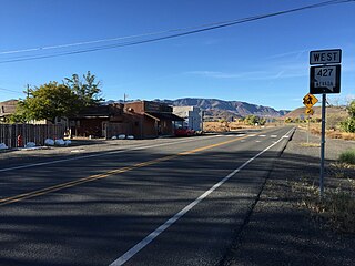
Wadsworth is a census-designated place (CDP) in Washoe County, Nevada. The population was 834 at the time of the 2010 census. It is part of the Reno–Sparks Metropolitan Statistical Area and located entirely within the Pyramid Lake Indian Reservation. The town was named for General James S. Wadsworth, a Civil War general killed during the Battle of the Wilderness in 1864. It was given this name by Leland Stanford of the Central Pacific Railroad as a favor to General Irvin McDowell, whom Wadsworth had served under during the Civil War.

The Black Rock Desert is a semi-arid region of lava beds and playa, or alkali flats, situated in the Black Rock Desert–High Rock Canyon Emigrant Trails National Conservation Area, a silt playa 100 miles (160 km) north of Reno, Nevada that encompasses more than 300,000 acres (120,000 ha) of land and contains more than 120 miles (200 km) of historic trails. It is in the northern Nevada section of the Great Basin with a lakebed that is a dry remnant of Pleistocene Lake Lahontan.

Pyramid Lake is the geographic sink of the basin of the Truckee River, 40 mi (64 km) northeast of Reno, Nevada, United States.

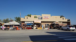
Gerlach, Nevada is a census-designated place (CDP) in Washoe County, Nevada, United States. The population was 130 at the 2020 census. It is part of the Reno–Sparks Metropolitan Statistical Area. Prior to 2010, Gerlach was part of the Gerlach–Empire census-designated place. The town of Empire is now a separate CDP. The next nearest town, Nixon, is 60 miles (100 km) to the south on a reservation owned by the Pyramid Lake Paiute Tribe. The Fly Geyser is located near Gerlach.
Empire is an unincorporated community and census-designated place (CDP) in Washoe County, Nevada, with a population estimated at 65 (2021). Prior to the 2010 census it was part of the Gerlach–Empire census-designated place, it is now part of the Reno–Sparks Metropolitan Statistical Area. The nearest town, Nixon, is 60 miles (97 km) to the south on a reservation owned by the Pyramid Lake Paiute Tribe.

The Truckee River is a river in the U.S. states of California and Nevada. The river flows northeasterly and is 121 miles (195 km) long. The Truckee is the sole outlet of Lake Tahoe and drains part of the high Sierra Nevada, emptying into Pyramid Lake in the Great Basin. Its waters are an important source of irrigation along its valley and adjacent valleys.

The Carson River is a northwestern Nevada river that empties into the Carson Sink, an endorheic basin. The main stem of the river is 131 miles (211 km) long although the addition of the East Fork makes the total length 205 miles (330 km), traversing five counties: Alpine County in California and Douglas, Storey, Lyon, and Churchill Counties in Nevada, as well as the Consolidated Municipality of Carson City, Nevada. The river is named for Kit Carson, who guided John C. Frémont's expedition westward up the Carson Valley and across Carson Pass in winter, 1844. The river made the National Priorities List (NPL) on October 30, 1990 as the Carson River Mercury Superfund site (CRMS) due to investigations that showed trace amounts of mercury in the wildlife and watershed sediments.

The Owens River is a river in eastern California in the United States, approximately 183 miles (295 km) long. It drains into and through the Owens Valley, an arid basin between the eastern slope of the Sierra Nevada and the western faces of the Inyo and White Mountains. The river terminates at the endorheic Owens Lake south of Lone Pine, at the bottom of a 2,600 sq mi (6,700 km2) watershed.
The Paiute War, also known as the Pyramid Lake War, Washoe Indian War and the Pah Ute War, was an armed conflict between Northern Paiutes allied with the Shoshone and the Bannock against settlers from the United States, supported by military forces. It took place in May 1860 in the vicinity of Pyramid Lake in the Utah Territory, now in the northwest corner of present-day Nevada. The war was preceded by a series of increasingly violent incidents, culminating in two pitched battles in which 79 Whites and 25 Indigenous people were killed. Smaller raids and skirmishes continued until a cease-fire was agreed to in August 1860; there was no treaty.

Washoe Lake is a lake located near Carson City in the Washoe Valley of Washoe County, Nevada. It is a very shallow lake with a surface area that can vary greatly from year to year. Washoe Lake State Park sits on the lake's southeastern shore.
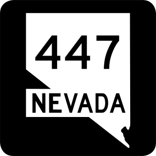
State Route 447 is a state highway in the U.S. state of Nevada. The highway is almost entirely within Washoe County but does for a brief time enter Pershing County, Nevada. The highway connects the town of Gerlach to the remainder of the state via Wadsworth. Though passing through extremely remote and desolate areas of Nevada, the highway has recently gained fame as the primary route to access the Black Rock Desert, the site of the annual Burning Man festival. The state maintained portion ends at Gerlach; however the highway continues as Washoe County Route 447 from Gerlach north to the California state line near Cedarville.
The Fox Range is a mountain range in east central Washoe County, Nevada.

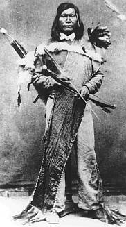
Numaga was a Paiute leader during the Paiute War of 1860 that centered on Pyramid Lake in what is now Nevada in the United States. The war was caused by an influx of miners and ranchers after silver was discovered in the Comstock Lode near to Carson City. The newcomers assaulted the Paiutes and destroyed their foods supplies. When the Paiutes responded, the U.S. Army used force to suppress them. Both before and after the war, Numaga was a strong advocate of peace and did much to reduce the violence on both sides. He died of tuberculosis, a "white man's disease", in 1871.
Hardin City was the site of a Nevada silver mining boom town from 1859 until about 1868. Hardin City was located on the western slope of the Black Rock Range in the Black Rock Desert.
New Year Lake is a lake in northwestern Washoe County, Nevada. It is situated in the Hays Canyon Range at an elevation of 5,948 feet. Explorer John C. Frémont passed New Year Lake on December 26, 1843 during his second expedition. The lake appeared unnamed on the map he created after the expedition in 1845.
Gerlach K-12 School is a public K-12 school in Gerlach, Nevada. A part of the Washoe County School District, its attendance boundary includes Gerlach and Empire.


