Rivers State, also known as Rivers, is a state in the Niger Delta region of southern Nigeria. Formed in 1967, when it was split from the former Eastern Region, Rivers State borders include Imo and Anambra to the north, Abia and Akwa Ibom to the east, and Bayelsa and Delta to the west.The State capital, Port Harcourt, is a metropolis that is considered to be the commercial center of the Nigerian oil industry.
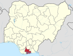
Bayelsa is a state in the South South region of Nigeria, located in the core of the Niger Delta. Bayelsa State was created in 1996 and was carved out from Rivers State, making it one of the newest states in the federation. The capital, Yenagoa, is susceptible to high risk of annual flooding. It shares a boundary with Rivers State to the east and Delta State to the north across the Niger River for 17 km and the Forçados River for 198 km, with the waters of the Atlantic Ocean dominating its southern borders. It has a total area of 10,773 square kilometres (4,159 sq mi). The state comprises eight local government areas: Ekeremor, Kolokuma/Opokuma, Yenagoa, Nembe, Ogbia, Sagbama, Brass and Southern Ijaw. The state is the smallest in Nigeria by population as of the 2006 census. Being in the Niger Delta, Bayelsa State has a riverine and estuarine setting, with bodies of water within the state preventing the development of significant road infrastructure.
Yenagoa is a Local Government Area and capital city of Bayelsa State, Southern Nigeria. It is located at the Niger-Delta region of the country at coordinates 4°55′29″N6°15′51″E.
Sagbama is a Local Government Area in Bayelsa State, Southern part of Nigeria. Its headquarters are in the town of Sagbama. Part of the area of the LGA lies within the Bayelsa National Forest.
Orumba South is a Local Government Area in Anambra State, south-eastern Nigeria. Umunze is the headquarters of Orumba South. Other towns that make up the local government are Akpujiogu (Akpu), Umuomaku, Eziagu, Ezira, Ihite, Nkerehi (Umuchukwu), Nawfija, Ogboji, Ogbunka, Owerre-Ezukala, Agbudu, Onneh, Isulo, and Enugwu-Umuonyia.
Ekwusigo is a Local Government Area in Anambra State, south-central Nigeria. Towns that make up the local government are Ozubulu, Oraifite, Ichi and Ihembosi.
Onitsha South is a Local Government Area in Anambrs North Senatorial zone of Anambra State, Nigeria. The headquarters is in Fegge, Onitsha. Onitsha South is predominantly commercial with popular markets such as Ochanja market which attracts thousands of buyers and sellers of variety of commodities. The revenue of Onitsha South Local Government Area is generated mostly from commercial activities.
Orumba North is a Local Government Area in Anambra State, East-central Nigeria.
Dẹgẹma is an Edoid language spoken in two separate communities on Degema Island in the Niger Delta, Nigeria, by about 120,000 people, according to 1991 census figures. The two communities are Usokun-Degema and Degema Town in the Degema Local Government Area in Rivers State. Each community speaks a mutually intelligible variety of Dẹgẹma, known by the names of the communities speaking them: the Usokun variety and the Degema Town variety. Both varieties are similar in their phonological, morphological, syntactic and semantic properties.
Numan, also known as Nomweh, is a town and a Local Government Area in Adamawa State, Nigeria. It is a port town that lies on the confluence of Benue River and Gongola River.
Shelleng is a Local Government Area (LGA) of Adamawa State, North-east Nigeria.
Isiala-Ngwa North is a Local Government Area of Abia State, Nigeria. Its headquarters is Okpuala-Ngwa.

Ukwa West is a Local Government Area in Abia State, Nigeria. Its headquarters is in the town of Oke Ikpe.
Southern Ijaw is a Local Government Area of Bayelsa State, Southern part of Nigeria. Its headquarters are in the town of Oporoma in the north of the area at 4°48′17″N6°04′44″E. The area has a coastline of approximately 60 km on the Bight of Benin.
Ogbia is a traditional Kingdom and Local Government Area of Bayelsa State in the Niger Delta region of Nigeria. The headquarters of both the Traditional Kingdom and Local Government is located in Ogbia Town at 4°39′00″N6°16′00″E.
Irepodun/Ifelodun is a Local Government Area of Ekiti State, Nigeria. Irepodun/Ifelodun is predominantly a homogeneous society and carefully populated by Yoruba speaking people of the South West of Nigeria. It has an area of 356 km2 and a population of 129,149 at the 2006 census. The major religions of the people are Christianity and Islam while a percentage of the people are traditional religion worshippers.

Akko is a local government area of Gombe, Gombe State, Nigeria. Its headquarters is in Kumo town on the A345 highway south of the state capital Gombe, about 40 km away. Kumo (headquarter) is a cosmopolitan communities of more than 30 differents tribes, ranging from the dominant Fulani tribe to Tangale, Tera, Hausa and other minorities.

Kaltungo is one among the 11 Local Governments Area of Gombe State, Nigeria. Its headquarters is in the town of Kaltungo in the western part of the Local Government Area on the A345 highway at 9°48′51″N11°18′32″E.
Asari-Toru is a Local Government Area in Rivers State, Nigeria.
Ogu–Bolo is a local government area (LGA) in Rivers State, Nigeria with headquarters in the town of Ogu. It is located on the Eastern Niger Delta.