Deicke and Millbrig bentonite layers

Last updated
The mapped area of the Deicke K-bentonite layer in the United States Map of Deicke K-Bentonite Layer.png
The mapped area of the Deicke K-bentonite layer in the United States

The Deicke and Millbrig bentonite layers, specifically the potassium bentonite layer, K-bentonite, were formed from a volcanic eruption during the Taconic orogeny during the Late Ordovician on Laurentia, the craton of North America. Researchers are very interested in the eruptions that formed these bentonite layers because they are thought to be some of the largest volcanic eruptions in the last 600 million years of Earth history, and the resulting ash layer for each eruption individually was greater in volume than the Toba eruption. Bentonite is a type of clay that is formed from the weathering of volcanic ash deposits. Some researchers suggested that the ashes were from a volcanic arc that was on a convergent crust boundary. [1] Researchers believe this because the trace element geochemistry of the bentonite shows that its source was a felsic calc-alkalic magmatic source, which is characteristic of volcanism from a continental crust destructive plate margin setting.

Contents

Origins

The volcanoes that caused the eruptions are said to be from a magmatic arc on continental crust in a convergent tectonic system. The Taconic orogeny occurred when North America collided with either an island arc or microcontinent. Also according to researchers a few statements can be made about the eruptions produced from this system: [1]

  1. Due to widespread ash deposits it can be inferred that there was more pyroclastic air fall debris than pyroclastic flow. A pyroclastic flow deposit would be much more localized to the eruption source.
  2. The large scale and dispersion of the ash tells researchers that the eruptions must have been very large and also have occurred in a convergent tectonic setting. Researchers believe this because the trace element geochemistry of the bentonite shows that its source was a felsic calc-alkalic magmatic source. This type of source is characteristic of volcanism from a continental crust destructive plate margin setting.
  3. The eruptions probably began with a Plinian or ultra-Plinian phase that produced a crystal-rich ash as a coignimbrite, air fall deposit
  4. The sequence of events is part of the normal sequence for volcanic eruptions in which ignimbrite is generated.
  5. In the area where the maximum bentonite thickness and grain size is recorded there is no evidence of nearby vent deposits, this means that these locations are at a minimum of several kilometers away from the volcano vents.

The volcanic eruption that produced the Deicke K-bentonite bed which has been dated to 457.1 ±1.0, which was calculated using a concordant uranium-lead dating zircon fraction. [2] The Deicke and Millbrig eruptions have a minimal estimation of 600,000 km2 (230,000 sq mi) covered and at least 1,122 km3 (269 cu mi) of pre-compaction bentonite that was accumulated over North America. [3] Some researchers believe that these eruptions could have caused a global cooling event, lowering the Earth's surface temperature several degrees. Other researchers did not find enough data to support the claim of significant cooling based on their sample location. [4] [5]

Field areas

There are many different areas where current field work is being done on the Deicke and Millbrig bentonite layers. Due to the large expanse of these layers in the geologic record outcrops can be found all over the country. Some researchers have worked in field areas in Deickeyville, Wisconsin; Guttenberg, Iowa; Bloody Run, Iowa; Decorah, Iowa; Locust, Iowa; Spring Grove, Minnesota; Sugar Creek, Minnesota; and Rochester, Minnesota. [6] These locations are listed from the southeast (Deickeyville) to the northwest (Rochester). The area sampled also is dominantly shale in the southeast and changes to a carbonate dominated outcrops in the northwest. Also some researchers work predominately in the Appalachians. Samples can be gathered from as far south as Birmingham, Alabama to Roanoke, Virginia and extending further north. [1]

Stratigraphy

The Deicke and Millbrig bentonite layers lie in the Decorah Formation, which is primarily composed of shale and carbonate rocks. The two bentonite layers are also separated by layers of shale and carbonate rocks. These layers in-between the units change as the units are correlated. In some areas the rock units between the bentonite layers are primarily shale and in those areas the carbonate rocks found normally are much thinner in thickness and are shalier than they are in other areas where this stratigraphic sequence is found. [6] Moreover, in other field areas the shale layer between the Deicke and Millbrig Bentonite layers is thinner and the carbonate rocks like wackestone are much more predominant. [7]

Bentonite layers

Several different types of bentonite can be found; however, potassium bentonite is the main one associated with the Deicke and Millbrig eruptions. The Deicke and Millbrig K-bentonite layers can be found from Alabama to New York to Minnesota. These K-bentonite layers are up to a meter thick in some locations. [8] Such thickness is unique. Most bentonite layers are very thin (only a few centimeters thick). Localities where the bentonite thickness and grain size are at their maximum are most likely close to the eruption sites. [9]

Trace element concentrations

Graph showing the cluster of data, with a +- 2 s uncertainty, from the electron microprobe analysis of apatite crystals found in the Deicke and Millbrig bentonite layers Trace Element Concentrations.jpg
Graph showing the cluster of data, with a ± 2 σ uncertainty, from the electron microprobe analysis of apatite crystals found in the Deicke and Millbrig bentonite layers

The Deicke and Millbrig bentonite layers can also be correlated due to certain elemental concentrations found in mineral inside of the bentonite layers. One such mineral that is useful is apatite. In one study done by Emerson et al. 2004, they compared the percent weight concentrations of manganese and magnesium in the mineral to differentiate between the two layers at different outcrops. For analysis of apatite for the Deicke bentonite layer, they collected 36 grains from two different locations and used electron microprobe analysis. Researchers found that there is a manganese weight percent of 0.02 and a magnesium weight percent 0.058. There were no significant differences found between the different localities. For the Millbrig bentonite layer, researchers found that there is a manganese weight percent of 0.064 and a magnesium weight percent 0.013. [6] For the Millbrig bentonite, there were also no significant differences between localities. The data that was collected had a ± 2 σ uncertainty. Using this information, current researchers can use similar methods to find the manganese and magnesium weight percentages and, depending on the data, can correlate the bentonite layers they find and identify them as either the Deicke or Millbrig bentonites. [6]

Effect on flora and fauna

While these bentonite layers are massive and spread across most of the eastern United States there is no evidence found of an extinction event in the geologic record. Based on data taken by Huff et al. 1992 from graptolite, acritarch, chitinozoan, conodont, and shelly fossils, there was no irregular extinction event found. Having no extinction event in this case is odd due to the large size of the ash fall. [10]

Current research efforts

Many scientists are working to see if this massive eruption caused a global cooling event. Some scientists are working with conodonts from the rock units surrounding the bentonite layers to see if there is a shift in the rare-earth element concentrations. If there is a shift in the concentration of certain elements, then that could potentially correlate to a shift from a tropical marine system to a cold marine system. Also sample localities could affect these concentrations, so it is crucial that researchers gather samples from all over the country where the bentonite beds have been confirmed to be from the Deicke eruption. [5]

Related Research Articles

The Ordovician is a geologic period and system, the second of six periods of the Paleozoic Era. The Ordovician spans 41.6 million years from the end of the Cambrian Period 485.4 million years ago (Mya) to the start of the Silurian Period 443.8 Mya.

<span class="mw-page-title-main">Tuff</span> Rock consolidated from volcanic ash

Tuff is a type of rock made of volcanic ash ejected from a vent during a volcanic eruption. Following ejection and deposition, the ash is lithified into a solid rock. Rock that contains greater than 75% ash is considered tuff, while rock containing 25% to 75% ash is described as tuffaceous. Tuff composed of sandy volcanic material can be referred to as volcanic sandstone.

<span class="mw-page-title-main">Volcanic cone</span> Landform of ejecta from a volcanic vent piled up in a conical shape

Volcanic cones are among the simplest volcanic landforms. They are built by ejecta from a volcanic vent, piling up around the vent in the shape of a cone with a central crater. Volcanic cones are of different types, depending upon the nature and size of the fragments ejected during the eruption. Types of volcanic cones include stratocones, spatter cones, tuff cones, and cinder cones.

<span class="mw-page-title-main">Mount Mazama</span> Complex volcano in the Cascade Range

Mount Mazama is a complex volcano in the state of Oregon, United States, in a segment of the Cascade Volcanic Arc and Cascade Range. Most of the mountain collapsed following a major eruption approximately 7,700 years ago. The volcano is in Klamath County, in the southern Cascades, 60 miles (97 km) north of the Oregon–California border. Its collapse, due to the eruption of magma emptying the underlying magma chamber, formed a caldera that holds Crater Lake. The mountain is in Crater Lake National Park. Mount Mazama originally had an elevation of 12,000 feet (3,700 m), but following its climactic eruption this was reduced to 8,157 feet (2,486 m). Crater Lake is 1,943 feet (592 m) deep, the deepest freshwater body in the US and the second deepest in North America after Great Slave Lake in Canada.

<span class="mw-page-title-main">Skarn</span> Hard, coarse-grained, hydrothermally altered metamorphic rocks

Skarns or tactites are hard, coarse-grained metamorphic rocks that form by a process called metasomatism. Skarns tend to be rich in calcium-magnesium-iron-manganese-aluminium silicate minerals, which are also referred to as calc-silicate minerals. These minerals form as a result of alteration which occurs when hydrothermal fluids interact with a protolith of either igneous or sedimentary origin. In many cases, skarns are associated with the intrusion of a granitic pluton found in and around faults or shear zones that commonly intrude into a carbonate layer composed of either dolomite or limestone. Skarns can form by regional, or contact metamorphism and therefore form in relatively high temperature environments. The hydrothermal fluids associated with the metasomatic processes can originate from a variety of sources; magmatic, metamorphic, meteoric, marine, or even a mix of these. The resulting skarn may consist of a variety of different minerals which are highly dependent on both the original composition of the hydrothermal fluid and the original composition of the protolith.

<span class="mw-page-title-main">Ignimbrite</span> Type of volcanic rock

Ignimbrite is a type of volcanic rock, consisting of hardened tuff. Ignimbrites form from the deposits of pyroclastic flows, which are a hot suspension of particles and gases flowing rapidly from a volcano, driven by being denser than the surrounding atmosphere. New Zealand geologist Patrick Marshall (1869-1950) coined the term ignimbrite from the Latin igni- [fire] and imbri- [rain].

<span class="mw-page-title-main">Geology of the Grand Teton area</span>

The geology of the Grand Teton area consists of some of the oldest rocks and one of the youngest mountain ranges in North America. The Teton Range, partly located in Grand Teton National Park, started to grow some 9 million years ago. An older feature, Jackson Hole, is a basin that sits aside the range.

<span class="mw-page-title-main">Taconic orogeny</span> Mountain-building period that affected most of New England

The Taconic orogeny was a mountain building period that ended 440 million years ago and affected most of modern-day New England. A great mountain chain formed from eastern Canada down through what is now the Piedmont of the East coast of the United States. As the mountain chain eroded in the Silurian and Devonian periods, sediments from the mountain chain spread throughout the present-day Appalachians and midcontinental North America.

<span class="mw-page-title-main">Yellowstone hotspot</span> Volcanic hotspot in the United States

The Yellowstone hotspot is a volcanic hotspot in the United States responsible for large scale volcanism in Idaho, Montana, Nevada, Oregon, and Wyoming, formed as the North American tectonic plate moved over it. It formed the eastern Snake River Plain through a succession of caldera-forming eruptions. The resulting calderas include the Island Park Caldera, Henry's Fork Caldera, and the Bruneau-Jarbidge caldera. The hotspot currently lies under the Yellowstone Caldera. The hotspot's most recent caldera-forming supereruption, known as the Lava Creek Eruption, took place 640,000 years ago and created the Lava Creek Tuff, and the most recent Yellowstone Caldera. The Yellowstone hotspot is one of a few volcanic hotspots underlying the North American tectonic plate; another example is the Anahim hotspot.

The Andean-Saharan glaciation, also known as the Early Palaeozoic Icehouse, the Early Palaeozoic Ice Age, the Late Ordovician glaciation, the end-Ordovician glaciation, or the Hirnantian glaciation, occurred during the Paleozoic from approximately 460 Ma to around 420 Ma, during the Late Ordovician and the Silurian period. The major glaciation during this period was formerly thought only to consist of the Hirnantian glaciation itself but has now been recognized as a longer, more gradual event, which began as early as the Darriwilian, and possibly even the Floian. Evidence of this glaciation can be seen in places such as Arabia, North Africa, South Africa, Brazil, Peru, Bolivia, Chile, Argentina, and Wyoming. More evidence derived from isotopic data is that during the Late Ordovician, tropical ocean temperatures were about 5 °C cooler than present day; this would have been a major factor that aided in the glaciation process.

<span class="mw-page-title-main">La Garita Caldera</span> Large caldera in the state of Colorado, U.S.

La Garita Caldera is a large caldera in the San Juan volcanic field in the San Juan Mountains around the town of Creede in southwestern Colorado, United States. It is west of La Garita, Colorado. The eruption that created the La Garita Caldera is among the largest known volcanic eruptions in Earth's history, as well as being one of the most powerful known supervolcanic events.

<span class="mw-page-title-main">Geology of the Australian Capital Territory</span> Overview of the geology of the Australian Capital Territory

The geology of the Australian Capital Territory includes rocks dating from the Ordovician around 480 million years ago, whilst most rocks are from the Silurian. During the Ordovician period the region—along with most of eastern Australia—was part of the ocean floor. The area contains the Pittman Formation consisting largely of Quartz-rich sandstone, siltstone and shale; the Adaminaby Beds and the Acton Shale.

<span class="mw-page-title-main">Calcite sea</span> Sea chemistry favouring low-magnesium calcite as the inorganic calcium carbonate precipitate

A calcite sea is a sea in which low-magnesium calcite is the primary inorganic marine calcium carbonate precipitate. An aragonite sea is the alternate seawater chemistry in which aragonite and high-magnesium calcite are the primary inorganic carbonate precipitates. The Early Paleozoic and the Middle to Late Mesozoic oceans were predominantly calcite seas, whereas the Middle Paleozoic through the Early Mesozoic and the Cenozoic are characterized by aragonite seas.

<span class="mw-page-title-main">Decorah Shale</span>

The Decorah Shale is a fossiliferous shale that makes up the lowermost formation in the Galena Group. The Decorah lies above the Platteville Limestone and below the Cummingsville Formation in the sedimentary sequence that formed from the shallow sea that covered central North America during Ordovician Time. The Decorah consists of three members : Spechts Ferry, Guttenberg, and Ion. The Spechts Ferry member is organic-rich and suggests a large influx of terrigenous sediment during deposition. The Guttenberg is characterized by nodular calcareous beds and contains several K-bentonite deposits. The Ion Member, present in the southern Decorah in Iowa, is characterized by alternating beds of shale and limestone.

<span class="mw-page-title-main">Laurentia</span> A large continental craton that forms the ancient geological core of the North American continent

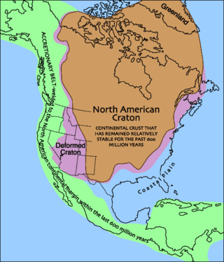
Laurentia or the North American Craton is a large continental craton that forms the ancient geological core of North America. Many times in its past, Laurentia has been a separate continent, as it is now in the form of North America, although originally it also included the cratonic areas of Greenland and also the northwestern part of Scotland, known as the Hebridean Terrane. During other times in its past, Laurentia has been part of larger continents and supercontinents and itself consists of many smaller terranes assembled on a network of Early Proterozoic orogenic belts. Small microcontinents and oceanic islands collided with and sutured onto the ever-growing Laurentia, and together formed the stable Precambrian craton seen today.

<span class="mw-page-title-main">Lava</span> Molten rock expelled by a volcano during an eruption

Lava is molten or partially molten rock (magma) that has been expelled from the interior of a terrestrial planet or a moon onto its surface. Lava may be erupted at a volcano or through a fracture in the crust, on land or underwater, usually at temperatures from 800 to 1,200 °C. The volcanic rock resulting from subsequent cooling is also often called lava.

<span class="mw-page-title-main">Geology of Uzbekistan</span>

The geology of Uzbekistan consists of two microcontinents and the remnants of oceanic crust, which fused together into a tectonically complex but resource rich land mass during the Paleozoic, before becoming draped in thick, primarily marine sedimentary units.

The geology of Yukon includes sections of ancient Precambrian Proterozoic rock from the western edge of the proto-North American continent Laurentia, with several different island arc terranes added through the Paleozoic, Mesozoic and Cenozoic, driving volcanism, pluton formation and sedimentation.

<span class="mw-page-title-main">Winneshiek Shale</span>

The Winneshiek Shale is a Middle Ordovician (Darriwilian-age) geological formation in Iowa. The formation is restricted to the Decorah crater, an impact crater near Decorah, Iowa. Despite only being discovered in 2005, the Winneshiek Shale is already renowned for the exceptional preservation of its fossils. The shale preserves a unique ecosystem, the Winneshiek biota, which is among the most remarkable Ordovician lagerstätten in the United States. Fossils include the oldest known eurypterid, Pentecopterus, as well as giant conodonts such as Iowagnathus and Archeognathus.

<span class="mw-page-title-main">Geology of the Ellsworth Mountains</span>

The geology of the Ellsworth Mountains, Antarctica, is a rock record of continuous deposition that occurred from the Cambrian to the Permian periods, with basic igneous volcanism and uplift occurring during the Middle to Late Cambrian epochs, deformation occurring in the Late Permian period or early Mesozoic era, and glacier formation occurring in the Cretaceous period and Cenozoic era. The Ellsworth Mountains are located within West Antarctica at 79°S, 85°W. In general, it is made up of mostly rugged and angular peaks such as the Vinson Massif, the highest mountain in Antarctica.

References

  1. 1 2 3 Haynes, John T. (1994). 290 : The Ordovician Deicke and Millbrig K-Bentonite Beds of the Cincinnati Arch and the Southern Valley and Ridge Province. Geological Society of America Special Papers. Vol. 290. Geological Society of America. pp. 1–80. doi:10.1130/SPE290-p1. ISBN   0-8137-2290-X.
  2. Samson, Scott D.; Patchett, P. Jonathan; Roddick, J. Chris; Parrish, Randall R. (1989). "Origin and tectonic setting of Ordovician bentonites in North America: Isotopic and age constraints". Geological Society of America Bulletin. Geological Society of America. 101 (9): 1175–1181. Bibcode:1989GSAB..101.1175S. doi:10.1130/0016-7606(1989)101<1175:OATSOO>2.3.CO;2.
  3. Huff, Warren D.; Kolata, Dennis R. (November 1990). "Correlation of the Ordovician Deicke and Millbrig K-Bentonites Between the Mississippi Valley and the Southern Appalachians". AAPG Bulletin. American Association of Petroleum Geologists. 74 (11): 1736–1747. doi:10.1306/0C9B2583-1710-11D7-8645000102C1865D.
  4. Herrmann, A. D.; Leslie, S. A.; MacLeod, K. G. (12 April 2011). "Did intense volcanism trigger the first Late Ordovician icehouse?: COMMENT". Geology. 39 (5): e237. Bibcode:2011Geo....39E.237H. doi: 10.1130/G31758C.1 .
  5. 1 2 Rosenau, Nicholas A.; Herrmann, Achim D.; Leslie, Stephen A. (January 2012). "Conodont apatite δ18O values from a platform margin setting, Oklahoma, USA: Implications for initiation of Late Ordovician icehouse conditions". Palaeogeography, Palaeoclimatology, Palaeoecology. 315–316: 172–180. Bibcode:2012PPP...315..172R. doi:10.1016/j.palaeo.2011.12.003.
  6. 1 2 3 4 Emerson, Norlene R.; Simo, J.A. Toni; Byers, Charles W.; Fournelle, John (5 August 2004). "Correlation of (Ordovician, Mohawkian) K-bentonites in the upper Mississippi valley using apatite chemistry: implications for stratigraphic interpretation of the mixed carbonate-siliciclastic Decorah Formation". AAPG Bulletin. American Association of Petroleum Geologists. 210 (2–4): 215–233. Bibcode:2004PPP...210..215E. doi:10.1016/j.palaeo.2004.02.042.
  7. John, A.; Klapper, Gilbert; Michael, A. (1997-01-01). "Use of K-bentonite beds as time-planes for high-resolution lithofacies analysis and assessment of net rock accumulation rate: An example from the upper Middle Ordovician of eastern North America". Paleozoic sequence stratigraphy, biostratigraphy, and biogeography. p. 18. ISBN   9780813723211.
  8. Herrmann, Achim D.; Macleod, Kenneth G.; Leslie, Stephen A. (2010). "Did a volcanic mega-eruption cause global cooling during the Late Ordovician?". PALAIOS. Society for Sedimentary Geology. 25 (12): 831–836. Bibcode:2010Palai..25..831H. doi:10.2110/palo.2010.p10-069r. S2CID   128676359.
  9. Haynes, John T. (1994). The Ordovician Deicke and Millbrig K-Bentonite Beds of the Cincinnati Arch and the Southern Valley and Ridge Province. Geological Society of America (Special Paper 290). p. 31. ISBN   9780813722900.
  10. Huff, Warren D.; Bergström, Stig M.; Kolata, Dennis R. (October 1992). "Gigantic Ordovician volcanic ash fall in North America and Europe: Biological, tectonomagmatic, and event-stratigraphic significance". Geology. Geological Society of America. 20 (10): 875–878. Bibcode:1992Geo....20..875H. doi:10.1130/0091-7613(1992)020<0875:GOVAFI>2.3.CO;2.