Delonegha Hot Springs

Last updated

Delonegha Hot Springs
Delonegha Springs, Kern County circa 1915.jpg
Delonegha Springs c.1909; the swinging bridge persisted until at least 1975 [1]
Delonegha Hot Springs
Coordinates 35°33′29″N118°36′43″W / 35.558°N 118.612°W / 35.558; -118.612 [2]
Elevation641 metres (2,103 ft) [3]
Type Thermal
Discharge95 L/min (25 U.S. gal/min)
Temperature44 °C (111 °F)

Delonegha Hot Springs are located in Kern County, California, United States, northeast of the city of Bakersfield and southeast of Glennville. Delonegha is one of several hot springs adjacent to the Kern River and State Route 178. The springs lie within the boundaries of Sequoia National Forest. Except for a brief period in the first years of the 20th century when there was a small resort at the site, the Delonegha springs have remained largely undeveloped.

Contents

History

The geothermally heated groundwater at Delonegha (also spelled Delonagha) was known to the indigenous people of the area, who reportedly used them "for medicinal purposes". [4] The springs take their name from the Dahlonegah Mining District where gold was found in 1866. Dahlonegah was in turn named after Dahlonega, Georgia, itself the site of an early 19th-century gold rush. [5] In the late 1860s, the first settlers of the springs district built a road to the top of Greenhorn Mountain "to connect with Eugene and Burke Grades" leading to Poso Flats and then into Bakersfield. [4] A stage ran this road twice a week. [1]

Homesteader William Crawford took possession of the springs and surrounding land in 1886, and according to his daughter, "Hot water poured out of the middle of big rocks and splashed into the river. I guess it still does. Papa built the bath house and the tubs on the edge of the river and piped water to it from a big spring up the mountain." [5] The springs were remote, accessible only by a single terrible road, and the surrounding land was still almost entirely wild, and populated by native California fauna including mountain lions, bobcats, foxes, bears, rattlesnakes, and scorpions. [6] A historian who interviewed Crawford's daughter Mae in 1965 wrote that "Miners and homesteaders stopped by occasionally. Most took baths in the bath house built by Mr. Crawford, soaking in the concrete tub filled with hot spring water, then lying, blanket-wrapped, on the sweat-board for an hour or so. Some bought cheese, goat's milk, and goat meat, and the family income was further augmented by the sale of the tough little burros to sheepherders." [7] After the Kern River flooded out the Crawford family for the third time, William Crawford "mortgaged the Springs to H. H. Fish, the man he was driving a hack for in Bakersfield, so he'd have the money to repair things with". [8] When Crawford defaulted on the mortgage, Fish evicted the family from the land. [8] Fish then leased Delonegha to Simeon and Dell Hill in about 1898. [8] The Hills built "a hotel, boarding house, several dwellings, and a bath," and the resort flourished for a time, particularly in 1905 and 1906. [9] According to a history of Kern County, "Hotel guests paid by the week, ate at the boardinghouse and bathed in the effervescent waters of the mineral springs. In spring, the hillsides around the resort blazed with orange poppies, blue lupine, and stately waxen yuccas. The thick trees and mountain shrubs shaded the resort from the summer sun and in the damp, shadowed places near the springs grew a multitude of violets." [9] However, in 1905, a new road was constructed between Bodfish and Democrat Hot Springs that bypassed Delongha and, over time, their resort business collapsed. [5] A young visitor who was there in 1909 later recalled "the steep ride down the mountain from the cow camp to the Springs, the handsome hotel with wide, shaded verandas, and the bustle of guests." [10] However, business was already in decline and the hotel closed by 1912. [10]

Delonegha Springs on a map of the route between Bakersfield and Little Lake, 1959 Bakersfield to Little Lake route 1959.jpg
Delonegha Springs on a map of the route between Bakersfield and Little Lake, 1959

Local historians who visited the site in 1956 found that "several dwellings remain intact and a small bathhouse is all that remains of the 'curative' pools, but the picturesque swinging footbridge across the Kern River that charmed a generation of years ago still spans the river, sturdy and exciting. Another item of nostalgia was the discovery of signs posted on nearby boulders in the heyday of the springs by early merchants in Bakersfield: the Toggery, Hochheimer's Department Store, Harrington's and C. N. Johnston's Blacksmith Shop, businesses that faded from the Bakersfield scene long ago." [11]

As of 1967, the property was owned by B. N. Kershaw but was "not at present open to the public". [4] Today, springs lie within the boundaries of the Sequoia National Forest, [12] and the old bath tubs were destroyed by U.S. Forest Service as a public safety measure in June 1977. [5]

Water profile

According to a U.S. government geologist in 1915, "At the western edge of Kern River, about 6 miles below the Clear Creek Springs, is a group of three hot springs that are called after a prospector named Delonegha. These springs issue a few feet above the river surface from crevices in fractured, massive granite. The water is distinctly sulphureted, but it does not seem to be otherwise notably mineralized. In 1908 there was a resort here, consisting of a small hotel and two bathhouses. The flow of two of the springs was collected in cement basins and used in the bathhouses, which were perched on the rocks above the river. The third spring issues too close to the river to be easily available." [13] A geothermal research project sponsored by NOAA found that the temperature of Delonegha water is 44 °C (111 °F) when it emerges from the source. [2] Flow rate is approximately 95 liters per minute. [12]

See also

Related Research Articles

<span class="mw-page-title-main">Kern River</span> Wild And Scenic River in California, United States

The Kern River, previously Río de San Felipe, later La Porciúncula, is an Endangered, Wild and Scenic river in the U.S. state of California, approximately 165 miles (270 km) long. It drains an area of the southern Sierra Nevada mountains northeast of Bakersfield. Fed by snowmelt near Mount Whitney, the river passes through scenic canyons in the mountains and is a popular destination for whitewater rafting and kayaking. It is the southernmost major river system in the Sierra Nevada, and is the only major river in the Sierra that drains in a southerly direction.

<span class="mw-page-title-main">Scovern Hot Springs</span> Former settlement in California, United States

Scovern Hot Springs is a thermal spring system, and former settlement in the Kern River Valley of the Southern Sierra Nevada, in Kern County, California.

<span class="mw-page-title-main">Miracle Hot Springs, California</span> Unincorporated community in California, United States

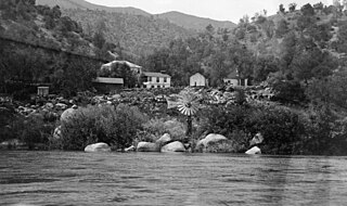
Miracle Hot Springs is an unincorporated community in the Kern River Valley, in Kern County, California. It is located along the Kern River in the Sequoia National Forest 10 miles (16 km) west of Lake Isabella, California, at an elevation of 2,382 feet (726 m).

<span class="mw-page-title-main">Gilman Hot Springs</span> Thermal springs in California

Gilman Hot Springs, also known as San Jacinto Hot Springs or the Relief Springs, is a hot spring system in the Inland Empire area of Southern California. Located near Potrero Creek, the San Jacinto River, and California State Route 79, the springs system consists of "about half a dozen" springs named for the Mexican land grant Rancho San Jacinto Viejo.

<span class="mw-page-title-main">Seminole Hot Springs, California</span> Unincorporated community in California, United States

Seminole Hot Springs is an unincorporated community in Los Angeles County, California, United States. Seminole Hot Springs is located in the Santa Monica Mountains near Cornell, 3.6 miles (5.8 km) south-southeast of Agoura Hills at an elevation of 932 feet (284 m).

<span class="mw-page-title-main">Bimini Baths</span> Los Angeles natatorium (1903–1951)

Bimini Baths was a geothermal mineral water public bathhouse and plunge in what is now Koreatown, Los Angeles, California, US. It was situated just west of downtown, near Third Street and Vermont Avenue. Bimini Baths contained a natatorium, swimming pools, swimming plunge, Turkish baths, a medical treatment department, and bottling works.

<span class="mw-page-title-main">Dirty Socks Hot Spring</span> Water source in California

Dirty Socks Hot Spring is a formerly developed hot spring near Death Valley, Inyo County, California, in the United States. A sulfur spring, the naturally occurring unpleasant odor may have been compared to smelly socks. The water is also often discolored with algae growth. Another explanation is that the spring was named from the fact miners washed their dirty socks there. The name may also be rendered as Dirty Sock, singular.

<span class="mw-page-title-main">Wheeler Springs, California</span> Unincorporated community in California, United States

Wheeler Springs is an unincorporated community that grew around a set of sulphurated hot springs in Ventura County, California. It is located 6 miles north of the Ojai Valley, within Los Padres National Forest. It is named for Wheeler Blumberg, who founded the town in 1891, and the many natural hot springs.

<span class="mw-page-title-main">Tuscan Springs</span> Geothermal feature in California

Tuscan Springs are a group of springs in the U.S. state of California. Tuscan Springs was named for the fact its borax-impregnated waters were chemically similar to the springs of Tuscany, in Italy.

<span class="mw-page-title-main">Verde Hot Springs</span> Thermal springs in Yavapai County, Arizona

Verde Hot Springs is a grouping of thermal mineral springs near the town of Camp Verde in Yavapai County, Arizona. The springs are located at the western bank of the Verde River. There are ruins of a former historical resort at the site and bathhouse.

<span class="mw-page-title-main">Penny Hot Springs</span> Thermal spring

Penny Hot Springs is a geothermal spring located near the historic mining town of Redstone, Colorado.

<span class="mw-page-title-main">Sespe Hot Springs</span> Thermal springs

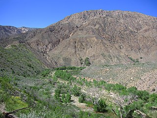
Sespe Hot Springs are a system of thermal springs and seeps that form a hot spring creek in the mountains near the Sespe Condor Sanctuary near Ojai, California.

<span class="mw-page-title-main">Truth or Consequences Hot Springs</span> Thermal springs system

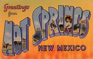
Truth or Consequences Hot Springs is a thermal spring system located in the Hot Springs Artesian Basin area of Truth or Consequences, New Mexico in Sierra County.

<span class="mw-page-title-main">Encino Hot Springs</span> Thermal springs

Encino Hot Springs are historic thermal springs located at the site of Siutcanga village, a settlement of the Tongva-Kizh people of the area now known as Southern California. It was used by several tribes of Indigenous peoples for thousands of years. Later, after settlement, the artesian springs were used as a water source for Rancho Los Encinos in what is now the San Fernando Valley region of Los Angeles County, California. In the 1880s it was a rest stop on the Butterfield Stagecoach route. The springs are located in the modern-day Los Encinos State Historic Park.

<span class="mw-page-title-main">Soboba Hot Springs</span> Geothermal site in California

Soboba Hot Springs are a historic hot springs and resort in Riverside County, California, United States. The springs issued from the side of a steep ravine "with narrow, precipitous sides, and the rock exposed is largely a crushed gneiss...the thermal character of the springs is due to crushing and slipping of the rocks". The Soboba Hot Springs resort was adjacent to the reservation of the Soboba Band of Luiseño Indians. Soboba means hot water in the Luiseño language.

<span class="mw-page-title-main">Eden Hot Springs</span> Geothermal site in California

Eden Hot Springs was a historic hot springs and resort in Riverside County, California, United States.

<span class="mw-page-title-main">Urbita Hot Springs</span> Geothermal site in California

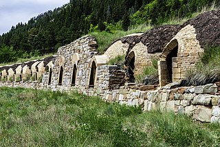
Urbita Hot Springs was a historic hot springs and amusement park in San Bernardino County, California, United States. Urbita Springs Park was located between E Street and Colton Street in San Bernardino where the Inland Center mall stands today.

<span class="mw-page-title-main">Camas Hot Springs</span> Thermal springs in Montana

Camas Hot Springs, also known as Big Medicine Hot Springs, is a group of historic hot springs in Hot Springs, Sanders County, Montana, United States.

<span class="mw-page-title-main">Alvarado Hot Springs</span> Defunct water source in California

Alvarado Hot Springs was a 20th-century geothermal well in Los Angeles County, California, United States. A bathhouse was built next to the water and a therapeutic spa was operated on the site for several decades.

<span class="mw-page-title-main">Democrat Hot Springs</span> Geothermal site in California

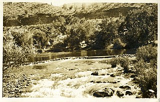
Democrat Hot Springs, named for the Democratic political party, is a geothermally heated spring located 17 miles (27 km) northeast of Bakersfield, California, United States, on the south bank of the Kern River and on the north side of California State Route 178.

References

  1. 1 2 Miller (1975), p. 10.
  2. 1 2 Berry, Grim & Ikelman (1980), p. 12.
  3. U.S. Geological Survey Geographic Names Information System: Delonegha Hot Springs
  4. 1 2 3 Bailey (1967), p. 6.
  5. 1 2 3 4 Powers (1979), p. 75.
  6. Powers (1979), p. 75–76.
  7. Henning (1980), p. 197.
  8. 1 2 3 Powers (1979), p. 77.
  9. 1 2 Powers (1979), p. 78.
  10. 1 2 Powers (1979), p. 81.
  11. "Gold Rush Town Site Discovered". The Los Angeles Times. November 25, 1956. p. 67. Retrieved 2024-04-12.
  12. 1 2 Higgins, Therberge & Ikelman (1980).
  13. Waring (1915), p. 51.

Sources

  • Bailey, Richard C. (1967). Kern County Place Names. Annual Publications of the Kern County Historical Society and Kern County Museum (No. 29). Introduction by Ralph F. Kreiser (1st ed.). Bakersfield, California: Merchants Printing and Lithographing Co. LCCN   74018077. OCLC   158106.
  • Berry, G. W.; Grim, P. J.; Ikelman, Joy A. (June 1980). Thermal Springs List for the United States (PDF) (Report). Key to Geophysical Records Documentation No. 12. Environmental Data and Information Service National Geophysical and Solar-Terrestrial Data Center. Boulder, Colo.: U.S. Department of Commerce, National Oceanic and Atmospheric Administration (NOAA). doi:10.2172/6737326.
  • Bischoff, Matt C. (2018). "Lake Isabella and the Kern River". Touring California and Nevada Hot Springs. Touring Hot Springs (4th ed.). FalconGuides. ISBN   978-1-4930-2912-9. OCLC   1024286436.
  • Henning, Charles (Summer 1980). O'Bryon, Martha Seffer (ed.). "She Had Some Times". The Pacific Historian. 24 (2). Stockton, California: University of the Pacific: 196–206. ISSN   0030-8676. JSTOR   community.28380812 .
  • Higgins, Chris T.; Therberge, Albert E. Jr.; Ikelman, Joy A. (1980). Geothermal Resources of California (PDF) (Map). NOAA National Geophysical Center. Sacramento: California Department of Mines and Geology.
  • Miller, Kent (June 23, 1975). "Highway 78 has colorful past but future changes doubtful". Metropolitan News Section. The Bakersfield Californian. Vol. 89, no. 174. pp. 9–10. ISSN   0276-5837 . Retrieved 2024-04-13 via Newspapers.com.
  • Powers, Bob (1979). Kern River Country. Pasadena: Westernlore Publications. ISBN   978-0-87026-052-0. LCCN   79064054. OCLC   5877346.
  • Waring, Gerald Ashley (January 1915). Springs of California. U.S. Department of the Interior, Geological Survey Water-Supply Papers. Washington, D.C.: U.S. Government Printing Office. doi:10.3133/wsp338. Water Supply Paper No. 338 via HathiTrust.PD-icon.svg This article incorporates text from this source, which is in the public domain.