Glennville, California

Last updated

Glennville
Linn's Valley
California Locator Map with US.PNG
Red pog.svg
Glennville
Location in California
Usa edcp location map.svg
Red pog.svg
Glennville
Glennville (the United States)
Coordinates: 35°43′44″N118°42′13″W / 35.72889°N 118.70361°W / 35.72889; -118.70361
Country United States
State California
County Kern County
Elevation
[1]
3,176 ft (968 m)

Glennville (formerly Linn's Valley) [2] is an unincorporated community in Kern County, California. [1]

Contents

Geography

It is located 30 miles (48 km) north-northeast of Bakersfield, [2] at an elevation of 3,176 feet (968 m) in the Greenhorn Mountains foothills, a range of the Sierra Nevada. [1]

Climate

Glennville has a typically Californian Mediterranean climate (Köppen Csb, bordering on Csa). Summers are hot during the day, with 51.5 afternoons during an average year topping 90 °F or 32.2 °C, but mornings remains pleasantly cool and dry. Winter days are comfortable with January's maximum averaging 56.4 °F or 13.6 °C, but mornings are cold and 117.6 mornings fall to or below freezing each year, although no morning has ever fallen to 0 °F or −17.8 °C – the coldest temperature recorded since records began occurring on February 6, 1989 when the mercury fell to 1 °F (−17.2 °C).

Precipitation is heavily concentrated in the winter and averages around 19.3 inches or 490 millimetres or about three times that of Bakersfield on the valley floor. The wettest month has been December 2010 with 13.77 inches (349.8 mm), whilst the wettest “rain year” has been from July 1997 to June 1998 with 42.51 inches (1,079.8 mm) and the driest from July 1958 to June 1959 when only 7.82 inches (198.6 mm) fell. [3] The wettest single day has been September 30, 1976 with 5.25 inches (133.4 mm); the only other day to top 4 inches or 101.6 millimetres being December 6, 1966 with 4.38 inches (111.3 mm). Snowfall averages 8.9 inches or 0.23 metres; the most in a month is 19.0 inches (0.48 m) in January 1982 and the most in a season 35.0 inches (0.89 m) between July 1998 and June 1999.

Climate data for Glennville, California, 1991–2020 normals, extremes 1951–2022
MonthJanFebMarAprMayJunJulAugSepOctNovDecYear
Record high °F (°C)83
(28)
81
(27)
86
(30)
89
(32)
99
(37)
103
(39)
107
(42)
103
(39)
104
(40)
97
(36)
89
(32)
82
(28)
107
(42)
Mean maximum °F (°C)71.4
(21.9)
72.1
(22.3)
75.5
(24.2)
80.9
(27.2)
87.6
(30.9)
94.8
(34.9)
98.7
(37.1)
98.0
(36.7)
94.1
(34.5)
87.3
(30.7)
78.8
(26.0)
72.1
(22.3)
100.2
(37.9)
Average high °F (°C)56.6
(13.7)
56.5
(13.6)
59.7
(15.4)
64.0
(17.8)
72.4
(22.4)
82.1
(27.8)
89.3
(31.8)
89.2
(31.8)
83.9
(28.8)
73.2
(22.9)
62.2
(16.8)
55.3
(12.9)
70.4
(21.3)
Daily mean °F (°C)42.4
(5.8)
43.2
(6.2)
46.1
(7.8)
49.5
(9.7)
56.4
(13.6)
63.8
(17.7)
70.7
(21.5)
69.8
(21.0)
64.7
(18.2)
55.5
(13.1)
47.0
(8.3)
41.4
(5.2)
54.2
(12.3)
Average low °F (°C)28.3
(−2.1)
29.8
(−1.2)
32.5
(0.3)
35.0
(1.7)
40.5
(4.7)
45.6
(7.6)
52.1
(11.2)
50.4
(10.2)
45.4
(7.4)
37.9
(3.3)
31.7
(−0.2)
27.4
(−2.6)
38.0
(3.3)
Mean minimum °F (°C)19.9
(−6.7)
20.1
(−6.6)
24.0
(−4.4)
25.8
(−3.4)
31.2
(−0.4)
35.9
(2.2)
45.0
(7.2)
43.5
(6.4)
37.1
(2.8)
29.6
(−1.3)
22.1
(−5.5)
18.1
(−7.7)
15.3
(−9.3)
Record low °F (°C)6
(−14)
1
(−17)
9
(−13)
19
(−7)
22
(−6)
28
(−2)
36
(2)
31
(−1)
29
(−2)
15
(−9)
10
(−12)
3
(−16)
1
(−17)
Average precipitation inches (mm)3.65
(93)
3.53
(90)
3.09
(78)
1.73
(44)
0.83
(21)
0.19
(4.8)
0.08
(2.0)
0.08
(2.0)
0.13
(3.3)
0.86
(22)
1.94
(49)
3.30
(84)
19.41
(493.1)
Average snowfall inches (cm)1.3
(3.3)
1.6
(4.1)
1.6
(4.1)
0.4
(1.0)
0.0
(0.0)
0.0
(0.0)
0.0
(0.0)
0.0
(0.0)
0.0
(0.0)
0.0
(0.0)
0.1
(0.25)
1.2
(3.0)
6.2
(16)
Average precipitation days (≥ 0.01 in)8.99.17.76.03.60.80.70.50.82.95.88.054.8
Average snowy days (≥ 0.1 in)0.81.00.80.20.00.00.00.00.00.00.10.83.7
Source: NOAA [4] [5]

History

The first white settlers in the area were George Ely and William Linn, who arrived together in 1854. Ely died in 1859 and Linn left the area around the same time. Linn's Valley post office opened in 1860 and the town changed its name to Glennville in 1872. [2] The name honors James Madison Glenn, a blacksmith [2] who settled the area in 1857 and opened the town's first hotel. [6] Glennville became the last stop on the stagecoach line from Visalia and the trading center for the surrounding valley after the decline of Lavers' Crossing. [2] In 1860, a state-funded wagon road from Glennville to Kernville was laid out by Thomas Baker, a civil engineer and founder of Bakersfield. A tribute to his ingenuity is that today's State Route 155 still follows Baker's route, originally known as the McFarlane Road, almost entirely.

Glennville remains a quiet country town with one restaurant and no gas station. The southernmost grove of Giant Sequoia trees, Deer Creek Grove, is located about ten miles northeast of Glennville. The Glennville adobe, built before the Civil War, still stands along Route 155 next to the fire station and is the oldest building in Kern County. The oldest standing church in the county, dating to 1866, stands nearby. [7] [8]

Related Research Articles

<span class="mw-page-title-main">Parker, Arizona</span> Town in La Paz County, Arizona

Parker is the county seat of La Paz County, Arizona, United States, on the Colorado River in Parker Valley. As of the 2020 census, the population of the city was 3,417.

<span class="mw-page-title-main">Bakersfield, California</span> City in California, United States

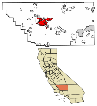
Bakersfield is a city in Kern County, California, United States. Bakersfield is the county seat of Kern County and is the largest city and the capital of Kern County. The city covers about 151 sq mi (390 km2) near the southern end of the San Joaquin Valley, which is located in the Central Valley region.

<span class="mw-page-title-main">Weaverville, California</span> Census-designated place in California, United States

Weaverville is a census-designated place and the county seat of Trinity County, California, United States. Its population is 3,667 as of the 2020 census, up from 3,600 from the 2010 census.

<span class="mw-page-title-main">South Lake Tahoe, California</span> City in California, United States

South Lake Tahoe is the most populous city in El Dorado County, California, United States, in the Sierra Nevada mountains. The city's population was 21,330 at the 2020 census, down from 21,403 at the 2010 census. The city, along the southern edge of Lake Tahoe, extends about 5 miles (8 km) west-southwest along U.S. Route 50, also known as Lake Tahoe Boulevard. The east end of the city, on the California–Nevada state line right next to the town of Stateline, Nevada, is mainly geared towards tourism, with T-shirt shops, restaurants, hotels, and Heavenly Mountain Resort with the Nevada casinos just across the state line in Stateline. The western end of town is mainly residential, and clusters around "The Y", the X-shaped intersection of US 50, State Route 89, and the continuation of Lake Tahoe Boulevard after it loses its federal highway designation.

<span class="mw-page-title-main">Minden, Nevada</span> County seat in Nevada, United States

Minden is a census-designated place (CDP) in Douglas County, Nevada, United States. The population was 3,001 at the 2010 census. It is the county seat of Douglas County and is adjacent to the town of Gardnerville. The Douglas campus of the Western Nevada College is located in Minden.

<span class="mw-page-title-main">Yerington, Nevada</span> City in Nevada, United States

Yerington is a city in Lyon County, Nevada, United States. The population was 3,048 at the 2010 census. It is the current county seat of Lyon County, with the first county seat having been established at Dayton on November 29, 1861. It is named after Henry M. Yerington, superintendent of the Virginia and Truckee Railroad from 1868 to 1910.

<span class="mw-page-title-main">Grants, New Mexico</span> City in New Mexico, United States

Grants is a city in Cibola County, New Mexico, United States. It is located about 78 miles (126 km) west of Albuquerque. The population was 9,163 at the 2020 Census. It is the county seat of Cibola County.

<span class="mw-page-title-main">Drain, Oregon</span> City in Oregon, United States

Drain is a city in Douglas County, Oregon, United States. The population was 1,151 at the 2010 census. Drain is named after town founder and politician Charles J. Drain, who donated 60 acres (24 ha) of nearby land to the Oregon and California Railroad in 1871.

<span class="mw-page-title-main">Newport, Oregon</span> City in Lincoln County, Oregon

Newport is a city in Lincoln County, Oregon, United States. It was incorporated in 1882, though the name dates back to the establishment of a post office in 1868. Newport was named for Newport, Rhode Island. As of the 2010 census, the city had a total population of 9,989, an increase of nearly 5% over its 2000 population; as of 2019, it had an estimated population of 10,853.

<span class="mw-page-title-main">Moro, Oregon</span> City in Oregon, United States

Moro is a city in Sherman County, Oregon, United States. The population was 324 at the 2010 census. It is the county seat of Sherman County It’s currently the least-populous county seat in Oregon. Moro was incorporated on February 17, 1899, by the Oregon Legislative Assembly. It was named for Moro, Illinois.

<span class="mw-page-title-main">Hebbronville, Texas</span> County seat and Census-designated place in Texas, United States

Hebbronville is a census-designated place (CDP) in and the county seat of Jim Hogg County, Texas, United States. The population was 4,558 at the 2010 census. In 1918, Helen Sewel Harbison became the first woman in Texas to cast a ballot, two years before the implementation of the Nineteenth Amendment to the United States Constitution.

<span class="mw-page-title-main">Richfield, Utah</span> City in the United States

Richfield is a city in and the county seat of Sevier County, Utah, United States, and is the largest city in southern-central Utah.

<span class="mw-page-title-main">Bridgeport, California</span> Census designated place and county seat in California, United States

Bridgeport is an unincorporated community and census-designated place (CDP) in Mono County, California, United States. It is the Mono county seat. The population was 553 at the 2020 census.

<span class="mw-page-title-main">Eureka, Nevada</span> Unincorporated town in the State of Nevada, United States

Eureka is an unincorporated town and census-designated places in and the county seat of Eureka County, Nevada, United States. With a population of 480 as of the 2018 American Community Survey 5-Year Estimates, it is by far the largest community in Eureka County. Attractions include the Eureka Opera House, Raine’s Market and Wildlife Museum, the Jackson House Hotel, and the Eureka Sentinel Museum.

<span class="mw-page-title-main">California State Route 155</span> Highway in California

State Route 155 is a state highway in the U.S. state of California connecting State Route 99 and State Route 178, going through the southern part of the Sierra Nevada mountain range. This highway runs from west to east. Its western terminus is in Delano and its eastern terminus is in the small town of Lake Isabella. Locally it is known as the Garces Highway.

<span class="mw-page-title-main">Climate of California</span> Overview of the climate of the U.S. state of California

The climate of California varies widely from hot desert to alpine tundra, depending on latitude, elevation, and proximity to the Pacific Coast. California's coastal regions, the Sierra Nevada foothills, and much of the Central Valley have a Mediterranean climate, with warmer, drier weather in summer and cooler, wetter weather in winter. The influence of the ocean generally moderates temperature extremes, creating warmer winters and substantially cooler summers in coastal areas.

<span class="mw-page-title-main">Summer Lake, Oregon</span> Unincorporated community in the state of Oregon, United States

Summer Lake is an unincorporated community in northwest Lake County, Oregon, United States. It is on Oregon Route 31 approximately halfway between Bend and Lakeview. It is at the base of the eastern slope of Winter Ridge adjacent to the Fremont–Winema National Forests.

<span class="mw-page-title-main">Fort Thomas, Arizona</span> CDP in Graham County, Arizona

Fort Thomas is a census-designated place in Graham County, Arizona, United States. Its population was 319 as of the 2020 census. The community has an elementary school and a high school. It is part of the Safford Micropolitan Statistical Area. Fort Thomas has a ZIP code of 85536.

<span class="mw-page-title-main">Climate of Los Angeles</span>

The climate of Los Angeles is mild to hot year-round, and mostly dry. It is classified as a Mediterranean climate, which is a type of dry subtropical climate. It is characterized by seasonal changes in rainfall—with a dry summer and a winter rainy season. Under the modified Köppen climate classification, the coastal areas are classified as Csb, and the inland areas as Csa.

Lavers' Crossing is a former settlement in Kern County, California. It was located 1 mile (1.6 km) west-northwest of Glennville, at the current junction of White River and Jack Ranch roads.

References

  1. 1 2 3 U.S. Geological Survey Geographic Names Information System: Glennville, California
  2. 1 2 3 4 5 Durham, David L. (1998). California's Geographic Names: A Gazetteer of Historic and Modern Names of the State. Clovis, Calif.: Word Dancer Press. p. 1040. ISBN   1-884995-14-4.
  3. National Weather Service, San Joaquin Valley; NOW Data – NOAA Online Weather Data
  4. "NOWData - NOAA Online Weather Data". National Oceanic and Atmospheric Administration. Retrieved May 29, 2022.
  5. "U.S. Climate Normals Quick Access – Station: Glennville, CA". National Oceanic and Atmospheric Administration. Retrieved May 27, 2023.
  6. David W. Kean, Wide Places in the California Roads: The encyclopedia of California's small towns and the roads that lead to them (Volume 1 of 4: Southern California Counties), p. 71
  7. David W. Kean, Wide Places in the California Roads: The encyclopedia of California's small towns and the roads that lead to them (Volume 1 of 4: Southern California Counties), p. 72
  8. Henrietta Ellis Case, By Casey Gaunttlis Case