Related Research Articles

Southern California is a geographic and cultural region that generally comprises the southern portion of the U.S. state of California. It includes the Los Angeles metropolitan area as well as the Inland Empire. The region generally contains ten of California's 58 counties: Imperial, Kern, Los Angeles, Orange, Riverside, San Bernardino, San Diego, Santa Barbara, San Luis Obispo and Ventura counties.

Bakersfield is a city in and the county seat of Kern County, California, United States. The city covers about 151 sq mi (390 km2) near the southern end of the San Joaquin Valley, which is located in the Central Valley region.

The Governor Edmund G. Brown California Aqueduct is a system of canals, tunnels, and pipelines that conveys water collected from the Sierra Nevada Mountains and valleys of Northern and Central California to Southern California. Named after California Governor Edmund Gerald "Pat" Brown Sr., the over 400-mile (640 km) aqueduct is the principal feature of the California State Water Project.

The Tejon Pass, previously known as Portezuelo de Cortes, Portezuela de Castac, and Fort Tejon Pass is a mountain pass between the southwest end of the Tehachapi Mountains and northeastern San Emigdio Mountains, linking Southern California north to the Central Valley. Both the pass and the grade north of it to the Central Valley are commonly referred to as "the Grapevine". It has been traversed by major roads such as the El Camino Viejo, the Stockton – Los Angeles Road, the Ridge Route, U.S. Route 99, and now Interstate 5.

Mechanics Bank Arena is a multi-purpose arena in Bakersfield, California. Located downtown at the corner of Truxtun Avenue and N Street, it was built in 1998, and was originally known as Centennial Garden, a name submitted by local resident Brian Landis. Bay Area-based Mechanics Bank has held the naming rights since September 2019, following their merger with Rabobank NA, which had held the naming rights since 2005.

The Diocese of Fresno (Latin: Dioecesis Fresnensis is a diocese of the Latin Church in the Central Valley of California in the United States. It is a suffragan diocese of the Archdiocese of Los Angeles.

Garces Memorial High School, commonly shortened to Garces High School, is a Catholic high school in Bakersfield, California.

Willow Springs is a village located around a set of former springs in Kern County, California, United States. It is located off of Rosamond Boulevard, 7.5 miles (12 km) west of Rosamond, at an elevation of 2,523 feet (769 m).
Kevin Harvick's Kern Raceway is a 0.5-mile (0.80 km) oval speedway located on CA 43 just off Interstate 5 in Bakersfield, Kern County, California, United States. Opened in 2013, it was built as a replacement for Mesa Marin Raceway.
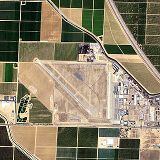
Shafter Airport, also known as Minter Field and formerly known as Air Corps Basic Flying School, is a public use airport located four nautical miles east of the central business district of Shafter and 14 miles northwest of Bakersfield, a city in Kern County, California, United States. Originally a World War II primary training facility for pilots, it is currently a public airport owned by the Minter Field Airport District. This airport is included in the National Plan of Integrated Airport Systems for 2011–2015, which categorized it as a general aviation facility.

Delia Amadora García Gerboles better known as Delia Garcés was an Argentine film actress of the Golden Age of Argentine Cinema (1940–1960). She made almost 30 appearances in film between 1937 and 1959 and acted on stage from 1936 to 1966. She won the Premios Sur Best Actress award three times from the Argentine Academy of Cinematography Arts and Sciences, as well as the Argentine Film Critics Association's Silver Condor Award for Best Actress, the Premios Leopold Torre Nilsson, Premio Pablo Podestá, and the inaugural ACE Platinum Lifetime Achievement Award from the Asociación de Cronistas del Espectáculo.

Garces Memorial Traffic Circle, informally known as Garces Circle or just The Circle, is a traffic circle in Bakersfield, California. The traffic circle is located at the intersection of Chester Avenue, Golden State Avenue and 30th Street. An overpass stands over the circle, allowing through traffic on Golden State Avenue to bypass it.
Rio Bravo is a former settlement in Kern County, California. It was located on the railroad 2 miles (3.2 km) north of Panama.

Kern River Slough was the distributary of the Kern River running northwest from the vicinity of Bakersfield to Goose Lake near Tulare Lake in Kern County, California.
Rancho San Emidio was a 17,710-acre (71.7 km2) Mexican land grant in present-day Kern County, California given in 1842 by Governor Juan Alvarado to José Antonio Dominguez. The grant was located along San Emigdio Creek in the northeastern foothills of the San Emigdio Mountains, between Santiago Creek on the west and Pleitito Creek on the east.

The Carpinteria Tar Pits are a series of natural asphalt lakes situated in the southern part of Santa Barbara County in southern California, US.
Connecting Slough, the former slough between Kern Lake and Buena Vista Lake in the southeastern San Joaquin Valley, in Kern County, California.
Bak-Anime is an annual two-day anime convention held at the Kern County Fairgrounds in Bakersfield, California by the staff of SacAnime. The convention is the sister conventions to the Bakersfield Comic Con, Sacramento Comic, Toy and Anime Show (Sac-Con), and SacAnime.

Glen Helen Regional Park is a county park located in San Bernardino, California, United States adjacent to the Cajon Pass. It was the site of both US Festivals of the early 1980s. It is also home to the Glen Helen Amphitheater, the largest outdoor amphitheater in the United States. The park also hosts several off-road races since 1985.

Taft Correctional Institution was a low-security federal prison for male inmates located in Taft, Kern County, California, owned by the Federal Bureau of Prisons (BOP) and operated by Management and Training Corporation under contract with the BOP. It also included a satellite prison camp for minimum-security male inmates.
References
- ↑ U.S. Geological Survey Geographic Names Information System: San Miguel de los Noches, California
- ↑ "Kern". CA State Parks. Archived from the original on December 13, 2012. Retrieved 2024-02-26.
- ↑ "Monuments in the Mojave desert". mojavedesert.net. Archived from the original on 2020-01-31. Retrieved 2020-01-31.

35°23′13″N119°01′08″W / 35.3869°N 119.01880°W
| | This Kern County, California-related article is a stub. You can help Wikipedia by expanding it. |