Pine Mountain Club, California

Last updated

Pine Mountain Club
Kern County California Incorporated and Unincorporated areas Pine Mountain Club Highlighted.svg
Location in Southwest Kern County and the state of California
USA California location map.svg
Red pog.svg
Pine Mountain Club
Location in the United States
Usa edcp location map.svg
Red pog.svg
Pine Mountain Club
Pine Mountain Club (the United States)
Coordinates: 34°50′49″N119°09′24″W / 34.84694°N 119.15667°W / 34.84694; -119.15667
Country United States
State California
County Kern
Government
   Senate Shannon Grove (R)
   Assembly Vince Fong (R)
   U. S. Congress Kevin McCarthy (R)
Area
[1]
  Total16.860 sq mi (43.667 km2)
  Land16.853 sq mi (43.649 km2)
  Water0.007 sq mi (0.017 km2)  0.044%
Elevation
5,554 ft (1,693 m)
Population
 (2010)
  Total2,315
  Density137.3/sq mi (53.0/km2)
Time zone UTC-8 (PST)
  Summer (DST) UTC-7 (PDT)
ZIP code
93222
Area code 661
FIPS code 06-57240
GNIS feature ID254419
Pine Mountain Club, California

Pine Mountain Club is an unincorporated community in southwestern Kern County, California. As of the 2010 census it had a population of 2,315. [2] For statistical purposes, the United States Census Bureau has defined Pine Mountain Club as a census-designated place (CDP). It is one of the Mountain Communities of the Tejon Pass.

Contents

Geography

Pine Mountain Club has an area of 16.7 square miles (43.25 km2). It ranges from 4,901 to 6,400 feet (1,494 to 1,951 m) in elevation. The community sits in a deep valley of the San Emigdio Mountains, on the San Andreas fault. It is surrounded by Los Padres National Forest. The settlement lies between Apache Saddle and Pinon Pines Estates along Mil Potrero Highway. It is west of Frazier Park, Lebec, and Interstate 5.

History

Founding and development

Pine Mountain Club was developed in 1971 by Tenneco. [3] The first announcement was made from Houston, Texas, in April of that year when the company said it would develop "more than 1.1 million acres of land in Arizona and Southern California." [4] [5] Tenneco was the Bakersfield-based western land-development arm of Tenneco, Inc., of Houston. [6]

About half that acreage was to be in Kern County, where the projects would include the residential development of 6,500 acres surrounding the then-new California State College near Bakersfield and 3,200 acres in the Los Padres National Forest, also mostly for residences (Pine Mountain Club). [4] [5]

The forest project was to set aside a thousand acres for vacation home sites and 2,200 acres "for permanent preservation in their natural state." The program was to be directed by John E. Sommerhalder, president of Tenneco West. [4] [5] [7] The land was part of a 3,200-acre tract of pine forest and meadowland, formerly a private preserve. [8]

Tenneco West was a Bakersfield subsidiary that administered all the western holdings of Tenneco, "the parent, Houston-based, multi-industry company." [9]

Adjacent to the clubhouse will be a nine-hole executive golf course[,] and other recreational facilities are a heated swimming pool, archery range, volleyball and basketball courts, a lake stocked with fish and a community barbecue area. [9]

Tenneco West President Sommerhalder said the club was believed to be among the largest all-electric family recreational resorts in California. Three kinds of "vacation or weekend homesites" were to be offered: (1) One- to three-bedroom dwellings, (2) modular homes, and (3) space for mobile homes. [9]

Hiking trails, bridle trails (16 miles marked for from one-hour to all-day rides), an equestrian center with 10-stall barn, tack room, riding ring and corrals for boarding horses also will be available. . . . Later this year, a general store and laundromat will be added. [9]

The prices were estimated to begin from about $13,500 for a one-bedroom house and lot. [7]

At the time of the announcement in 1971, "four deep wells" had already been sunk and an "extensive network of reservoirs and pipelines" laid, with a filtration plant near the commercial center. [7]

Sommerhalder said the developer had the "assistance of Simon Eisner, nationally known environmental planner." [9]

Eight months after the opening, seventy-nine percent of the 1,309 purchasers indicated in a survey that construction of a vacation home was the prime reason for buying a lot and 43% of that group said they intended to start building during 1972. [10]

The development's sixth and final section, on a plateau some thousand feet higher than the clubhouse, went on sale in March 1973. [11]

Mil Potrero Highway

Tenneco West improved a "winding, steep, one-lane dirt road" called Mil Potrero west from Pine Mountain Club to California State Highway 33 into a "comfortable, convenient and safe way . . . to view what is generally regarded as Southern California's most strikingly beautiful scene." The cost for the 6.5-mile segment was estimated at nearly a million dollars. John E. Sommerhalder, the company president, said the road opened up "a large segment of the [Los Padres National] forest that, until now, has been almost inaccessible." [12]

The job was unusually difficult, partly because of the mountainous terrain and partly because of protective and restorative measures taken to reduce to a minimum the disturbance to the natural surroundings. . . . The project had to conform to the specifications and requirements of both Kern County and the U.S. Forest Service. In effect, it is already a public road, although Tenneco must maintain it for a year before the formal dedication as a public road can take place. [12]

To keep damages to the forest at a minimum, contractors Yeager Construction of Riverside and Desert Construction of Victorville were required to do all the work from the existing right-of-way and forbidden to build a temporary construction road alongside. Fire-protection equipment had to be on hand at all times. [13]

Fruition

By 1988, Pine Mountain Club had a small commercial district with about forty businesses, ranging from a Exxon gas station to a place called "Pheasants by Frank." According to the Newhall Signal, the district was "more or less shut down on Mondays and Tuesdays . . . because there are so many people with weekend homes that the stores choose to stay open Saturday and Sunday." [14]

On July 31, 2021, the community celebrated its fiftieth birthday with a barbecue picnic on blankets spread beneath the trees next to the golf course. Also noted was the 50th anniversary of the founding of the Mil Potrero Mutual Water Company. [15]

Demographics

2010 census

The 2010 United States Census [16] reported that Pine Mountain Club had a population of 2,315. The population density was 137.3 inhabitants per square mile (53.0/km2). The racial makeup was 2,079 (89.8%) white, 29 (1.3%) African American, 25 (1.1%) Native American, 45 (1.9%) Asian, 0 (0.0%) Pacific Islander, 58 (2.5%) from other races, and 79 (3.4%) from two or more races. Hispanic or Latino of any race were 231 persons (10.0%).

Pine Mountain Club and the Los Padres National Forest Pine-Mountain-Club-Rocks.jpg
Pine Mountain Club and the Los Padres National Forest

There were 1,062 households, of which 226 (21.3%) had children under the age of 18 living in them, 585 (55.1%) were opposite-sex married couples living together, 62 (5.8%) had a female householder with no husband present, and 36 (3.4%) had a male householder with no wife present. There were 49 (4.6%) unmarried opposite-sex partnerships, and 13 (1.2%) same-sex married couples or partnerships. Three hundred eighteen households (29.9%) were made up of individuals, and 111 (10.5%) had someone living alone who was 65 years of age or older. The average household size was 2.18. There were 683 families (64.3% of all households); the average family size was 2.68 persons.

Four hundred eleven people (17.8%) were under the age of 18, 105 were (4.5%) aged 18 to 24, 355 (15.3%) aged 25 to 44, 929 (40.1%) aged 45 to 64, and 515 (22.2%) 65 years or older. The median age was 51.6 years. For every 100 females, there were 102.9 males. For every 100 women age 18 and over, there were 103.2 men.

There were 2,181 housing units at an average density of 129.4 per square mile (50.0/km2), of which 880 (82.9%) were owner-occupied, and 182 (17.1%) were renter-occupied. The homeowner vacancy rate was 6.1%; the rental vacancy rate was 17.8%. Exactly 1,884 people (81.4% of the population) lived in owner-occupied housing units and 431 (18.6%) in rentals.

2000 census

The 2000 census found that almost 91 percent of the sixteen hundred residents were white. There were nine blacks. There were 146 Hispanics or Latinos of any race. Other residents included 19 American Indians or Alaska natives and 12 Asians. [17]

Residences of the area Pine-Mountain-Club-Scenic.jpg
Residences of the area

It was a relatively aged population, the median age being 45 years compared with 35 years for the nation as a whole. PMC also had more veterans than its share — 263, or 21 percent, compared to 13 percent around the country. In contrast with the country at large, where 64 percent of the people were working, Pine Mountain Club had just 56 percent employed. Those who were working had to travel about an hour to their jobs, compared to 25 minutes for most Americans.

It was a high-income area — $62,750 median family income, compared to $50,046 in the nation at large. In per capita income, it stood at $25,465 — just between Diamond Bar and Mira Monte among other towns in California.

Yet there were still 55 families (or 15 percent) below the poverty level in Pine Mountain Club in 2000. That is greater than the 12 percent for the country as a whole.

Almost two-thirds of its 1,737 housing units (61.5 percent) were vacant when the census [17] was taken in March 2000. Owners lived in about eight of every 10 occupied units (84 percent), renters in the other two (16 percent).

Community management

PMC golf course, with Mt. Pinos in the background Mt Pinos.jpg
PMC golf course, with Mt. Pinos in the background

The PMC community is managed by the Pine Mountain Club Property Owners Association, Inc., [18] which is governed by a nine-member volunteer board of directors and a group of documents: the Covenants, Conditions, and Restrictions (CC&R's ), bylaws, the association rules, and an Environmental Control (EC) code . The association maintains several recreational facilities , including a nine-hole golf course, pool, clubhouse, and stables. [19] It manages the Pine Mountain Patrol and publishes a monthly newspaper, the Condor .

Education

Pine Mountain Club is part of the El Tejon Unified School District, and students are transported by bus to local public schools, including Frazier Mountain High School. The community hosts a charter school, Peak to Peak Mountain Charter, serving grades kindergarten through seventh. [20] The private Mountain Community Christian School serves kindergarten through sixth-grade pupils.

Transportation

Kern Regional Transit provides bus service Thursdays and Saturdays during the summer to Frazier Park, Gorman, Lake of the Woods, Lebec, and Pinon Pines. It offers a dial-a-ride service all year. Connections can be made in Frazier Park or Lebec to a scheduled service to Grapevine and Bakersfield and further connection there to Greyhound and Amtrak. [21]

Economy

The area is served by the Mountain Communities Chamber of Commerce. [22]

Wildlife

Black bears began commonly disturbing the community by breaking into homes and vehicles around 2014. Considered a human-black bear conflict zone by wildlife authorities, the issue is a challenge for the community especially when the bears emerge from their winter hibernation to search for food in the spring. [23]

Media

Pine Mountain Club is a private community.
Click the images to see larger versions of the photos, all from 2008.

Related Research Articles

<span class="mw-page-title-main">Kern County, California</span> County in California, United States

Kern County is a county located in the U.S. state of California. As of the 2020 census, the population was 909,235. Its county seat is Bakersfield.

<span class="mw-page-title-main">Bakersfield, California</span> City in California, United States

Bakersfield is a city in and the county seat of Kern County, California, United States. The city covers about 151 sq mi (390 km2) near the southern end of the San Joaquin Valley, which is located in the Central Valley region.

<span class="mw-page-title-main">California City, California</span> City in California, United States

California City is a city located in northern Antelope Valley in Kern County, California, United States. It is 100 miles (160 km) north of the city of Los Angeles, and the population was 14,973 at the 2020 census. Covering 203.63 square miles (527.4 km2), California City has the third-largest land area of any city in the state of California, and is the largest city in California, by land area, that is not a county seat. It is the 43rd-largest city in the United States by land area.

<span class="mw-page-title-main">Frazier Park, California</span> Unincorporated community in California, United States

Frazier Park is an unincorporated community and census-designated place in Kern County, California. It is 5 miles (8 km) west of Lebec, at an elevation of 4,639 feet (1,414 m). It is one of the Mountain Communities of the Tejon Pass. The population was 2,592 in the 2020 census, down from 2,691 in 2010.

<span class="mw-page-title-main">Lake of the Woods, California</span> Census-designated place in California, United States

Lake of the Woods is an unincorporated area and census-designated place (CDP) in southwestern Kern County, California. As of the 2020 census, the population was 790.

<span class="mw-page-title-main">Lebec, California</span> Census-designated place in California, United States

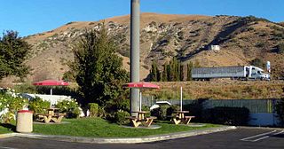
Lebec is an unincorporated community and census-designated place in southwestern Kern County, California. As of the 2010 census, the population was 1,468.

<span class="mw-page-title-main">Gorman, California</span> Unincorporated community in California, United States

Gorman is an unincorporated community in northwestern Los Angeles County, California, United States. It is located in Peace Valley south of the Tejon Pass, which links Southern California with the San Joaquin Valley and Northern California. Due to this location, the area has served as a historic travel stop dating back to the indigenous peoples of California. Tens of thousands of motorists travel through Gorman daily on the Golden State Freeway since the highway's completion in the mid-20th Century.

<span class="mw-page-title-main">Grapevine, California</span> Unincorporated community in California, United States

Grapevine is an unincorporated community in Kern County, California, United States, at the southern end of the San Joaquin Valley. The small village is directly adjacent to Interstate 5 and consists mainly of travelers and roadside services. At an elevation of 1,499 feet (457 m), the community is located at the foot of a grade known as the Grapevine that lies in Grapevine Canyon through the Tejon Pass.

Tejon Ranch Company, based in Lebec, California, is one of the largest private landowners in California. The company was incorporated in 1936 to organize the ownership of a large tract of land that was consolidated from four Mexican land grants acquired in the 1850s and 1860s by ranch founder Edward Fitzgerald Beale.

<span class="mw-page-title-main">Mount Pinos</span> Mountain of the Transverse Ranges in California, United States

Mount Pinos is a mountain located in the Los Padres National Forest on the boundary between Ventura and Kern counties in California. The summit, at 8,847 feet (2,697 m), is the highest point in Ventura County. The mountain is the highest point of the Transverse Ranges west of Tejon Pass, as well as the southernmost point of the Salinian Block.

<span class="mw-page-title-main">Area code 661</span> Area code in central and southern California, United States

Area code 661 is a telephone area code in the North American Numbering Plan for the southern part of the San Joaquin Valley and for the far northern part of the Los Angeles metropolitan area. The numbering plan area comprises most of Kern County, most of northern Los Angeles County, and small parts of Ventura County, Santa Barbara County, and Tulare County. It was created in an area code split of area code 805 on February 13, 1999.

<span class="mw-page-title-main">Chumash Wilderness</span> Protected wilderness area in California, United States

The Chumash Wilderness is a 38,150 acres (15,440 ha) wilderness area within the southern Los Padres National Forest. It is located in the Transverse Ranges, in northern Ventura County and southwestern Kern County in California.

The El Tejon Unified School District serves kindergarten-through-12th-grade students in the Mountain Communities of the Tejon Pass, which include Frazier Park, Lebec, and Pine Mountain Club in the southern mountains of Kern County, California. Lockwood Valley is part of the district even though it is within Ventura County, and Gorman students are accepted into the high school by special permit.

<span class="mw-page-title-main">Mountain Communities of the Tejon Pass</span> Communities in Kern, Los Angeles and Ventura counties, California

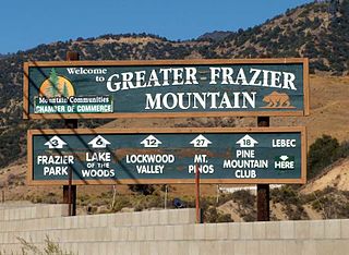
The Mountain Communities of the Tejon Pass, or the Frazier Mountain Communities, in the San Emigdio Mountains is a region of California that includes Lebec, Frazier Park, Lake of the Woods, Pinon Pines, and Pine Mountain Club, in Kern County, Gorman in Los Angeles County and Lockwood Valley within Kern and Ventura counties. They are all within or near the Tejon Pass, which links Southern California with the San Joaquin Valley. Also sometimes included within the communities are Cuddy Valley, Grapevine, Neenach and New Cuyama.

The Mountain Enterprise is a weekly newspaper published since 1966, circulating in the Mountain Communities of the Tejon Pass east and west of the Grapevine section of the Interstate 5 in the San Emigdio Mountains region of California, midway between Los Angeles and Bakersfield. Its sister publication is The New Mountain Pioneer, published monthly.

Kim Noller was the editor of the Mountain Enterprise, a weekly newspaper serving the Mountain Communities of the Tejon Pass and headquartered in Frazier Park, Kern County, California. He was born in Tampa, Florida, to Charles Noller and Jane Tebbets Noller, and died in Bethlehem, Georgia.

Tejon Mountain Village is a proposed residential, commercial, and recreational development of pristine, rugged property in the Tehachapi Mountains owned by the Tejon Ranch Company in Lebec, southern Kern County, California. The development includes the largest conservation and land-use agreement in California history. It was approved by the county's Board of Supervisors in October 2009. Opponents launched a legal challenge that was denied in state district court in April 2012.

The Bakersfield Department of Water Resources is a municipal utility in Bakersfield, California. Primarily it manages the city's water rights to the Kern River. Water is sent to water retailers that the city has contracts with, and recharge basins to seep into the groundwater table. The department also manages water distributions to most of Southwest Bakersfield and a small part of Northwest Bakersfield.

<span class="mw-page-title-main">Ray Watson (broadcaster)</span>

Raymond A. (Ray) Watson is a former American television executive who was a member of the Board of Supervisors in Kern County, California, representing the western part of the county, between November 2002 and November 2012. He was chairman of the board in 2010. Watson was named Broadcaster of the Year by the California Broadcasters Association in 2002. He was on the advisory committee of the Carrizo Plain National Monument and was a director of the San Joaquin Valley Air Pollution Control District.

<span class="mw-page-title-main">McBean Regional Transit Center</span> Transit center in Santa Clarita, California

McBean Regional Transit Center, also known by its acronym MRTC, is a transit center and bus station located at 24375 Valencia Boulevard in the Valencia area of Santa Clarita, California, near the intersection of Valencia Boulevard and McBean Parkway. It is located next to the Westfield Valencia Town Center.

References

  1. U.S. Census Archived 2012-01-25 at the Wayback Machine
  2. "Geographic Identifiers: 2010 Demographic Profile Data (G001): Pine Mountain Club CDP, California". U.S. Census Bureau, American Factfinder. Retrieved January 25, 2019.[ dead link ]
  3. "PMC Turns 50 With Enthusiasm," The Mountain Enterprise, August 6, 2021, page 5
  4. 1 2 3 Associated Press, "Tenneco Tells Plans for Major Land Developments," Santa Cruz Sentinel, April 14, 1971, image 14
  5. 1 2 3 Associated Press, "Homes Will Surround New Bakersfield Campus," Oakland Tribune, April 18, 1971, image 67
  6. "Of Real Estate and People," Los Angeles Times, April 18, 1971, image 182
  7. 1 2 3 Dick Turpin, "Pine Mountain Resort," Los Angeles Times, June 13, 1971, image 148
  8. "Vacation Resort Area Being Built," Daily News-Post, Monrovia, California, June 17, 1971, image 11
  9. 1 2 3 4 5 Turpin, "Pine Mountain Club: Family Hideaway," Los Angeles Times, June 13, 1971, image 125
  10. "Pine Mountain Club Reports on Building," Los Angeles Times, August 6, 1972, image 147
  11. "Added Lots Available at Pine Mountain Club," Los Angeles Times, March 27, 1973, image 136
  12. 1 2 "It's Now Mil Potrero Road," The Hanford Sentinel, February 26, 1972, image 90
  13. "Road Improved," The Hanford Sentinel, February 26, 1972, image 92
  14. J.J. Jackson, "Carl's Leads the Way to 'The Hill,'" The Signal, Santa Clarita, September 18, 1988, image 22
  15. Patric Hedlund, "PMC Turns 50 With Enthusiasm," The Mountain Enterprise, August 6, 2021
  16. "2010 Census Interactive Population Search: CA - Pine Mountain Club CDP". U.S. Census Bureau. Archived from the original on July 15, 2014. Retrieved July 12, 2014.
  17. 1 2 "U.S. Census website". United States Census Bureau . Retrieved January 31, 2008.
  18. "PMCPOA Inc". Archived from the original on October 14, 2007. Retrieved October 24, 2007.
  19. Cox, John (March 11, 2023). "County steps in after snowstorm overwhelms Pine Mountain Club". The Bakersfield Californian. Retrieved March 12, 2023.
  20. "Pine Mountain Learning Center Among State's First Certified Charter Schools," Mountain Enterprise, October 19, 2007.
  21. Kern Regional Transit bus routes.
  22. Mountain Communities Chamber of Commerce.
  23. Sahagún, Louis (March 18, 2024). "As hungry bears awaken from hibernation, a California mountain village braces for invasion". Los Angeles Times. Retrieved March 19, 2024.