Midoil, California

Last updated
Midoil
Unincorporated community
California Locator Map with US.PNG
Red pog.svg
Midoil
Location in California
Usa edcp location map.svg
Red pog.svg
Midoil
Midoil (the US)
Coordinates: 35°09′30″N119°31′21″W / 35.15833°N 119.52250°W / 35.15833; -119.52250 Coordinates: 35°09′30″N119°31′21″W / 35.15833°N 119.52250°W / 35.15833; -119.52250
Country United States
State California
County Kern County
Elevation [1] 1,339 ft (408 m)

Midoil (formerly, Midland) is an unincorporated community in Kern County, California. [1] It is located 2 miles (3.2 km) southeast of Fellows, [2] at an elevation of 1,339 feet (408 m). [1]

Unincorporated area Region of land not governed by own local government

In law, an unincorporated area is a region of land that is not governed by a local municipal corporation; similarly an unincorporated community is a settlement that is not governed by its own local municipal corporation, but rather is administered as part of larger administrative divisions, such as a township, parish, borough, county, city, canton, state, province or country. Occasionally, municipalities dissolve or disincorporate, which may happen if they become fiscally insolvent, and services become the responsibility of a higher administration. Widespread unincorporated communities and areas are a distinguishing feature of the United States and Canada. In most other countries of the world, there are either no unincorporated areas at all, or these are very rare; typically remote, outlying, sparsely populated or uninhabited areas.

Kern County, California County in California, United States

Kern County is a county in the U.S. state of California. As of the 2010 census, the population was 839,631. Its county seat is Bakersfield.

California State of the United States of America

California is a state in the Pacific Region of the United States. With 39.6 million residents, California is the most populous U.S. state and the third-largest by area. The state capital is Sacramento. The Greater Los Angeles Area and the San Francisco Bay Area are the nation's second and fifth most populous urban regions, with 18.7 million and 9.7 million residents respectively. Los Angeles is California's most populous city, and the country's second most populous, after New York City. California also has the nation's most populous county, Los Angeles County, and its largest county by area, San Bernardino County. The City and County of San Francisco is both the country's second-most densely populated major city after New York City and the fifth-most densely populated county, behind only four of the five New York City boroughs.

Midoil is no longer a permanently populated place. It is within the zone of active operations of the Midway-Sunset Oil Field, about midway between Fellows and Taft, along Midoil Road, which winds through the pumpjacks, pipelines, and tank batteries, roughly paralleling California State Route 33 about a mile to the northeast. Chevron Corporation is the primary operator in the area.

Midway-Sunset Oil Field

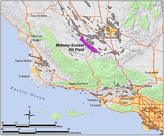
The Midway-Sunset Oil Field is a large oil field in Kern County, San Joaquin Valley, California in the United States. It is the largest known oilfield in California and the third largest in the United States.

California State Route 33 highway in California

State Route 33 is a north–south state highway in the U.S. state of California. It runs north from Ventura through the Transverse Ranges and the western side of the San Joaquin Valley to a point east of Tracy. SR 33 replaced part of U.S. Route 399 in 1964 during the "great renumbering" of routes. In the unincorporated sections of Kern County it is known as the West Side Highway. In addition, the California Legislature designated the entire Kern County portion as the Petroleum Highway in 2004. The southernmost portion in Ventura is a freeway known as the Ojai Freeway, while it is known as the Maricopa Highway from Ojai to Maricopa.

Chevron Corporation American multinational energy corporation

Chevron Corporation is an American multinational energy corporation. One of the successor companies of Standard Oil, it is headquartered in San Ramon, California, and active in more than 180 countries. Chevron is engaged in every aspect of the oil, natural gas, and geothermal energy industries, including hydrocarbon exploration and production; refining, marketing and transport; chemicals manufacturing and sales; and power generation. Chevron is one of the world's largest oil companies; as of 2017, it ranked nineteenth in the Fortune 500 list of the top US closely held and public corporations and sixteenth on the Fortune Global 500 list of the top 500 corporations worldwide. It was also one of the Seven Sisters that dominated the global petroleum industry from the mid-1940s to the 1970s.

A post office operated at Midland from 1908 to 1914. [2]

Related Research Articles

Midland may refer to:

Midland County, Michigan County in the United States

Midland County is a county located in the U.S. state of Michigan. As of the 2010 census, the population was 83,629. The county seat is Midland. The county's name is due to its closeness to the geographical Lower Peninsula's geographical center. It was founded in 1831. However, it was not until 1855 that the county was effectively organized.

Fellows, California census-designated place in California, United States

Fellows is a census-designated place (CDP) in Kern County, California, United States. Fellows is located 5 miles (8 km) west-northwest of Taft, at an elevation of 1,316 feet (401 m). The population was 106 at the 2010 census, down from 153 at the 2000 census. Fellows is surrounded on all sides by the enormous Midway-Sunset Oil Field, the third-largest oil field in the United States, and the oil and gas industry accounts for much of the area's economic activity.

Maricopa, California City in California, United States

Maricopa is a city in Kern County, California. Maricopa is located 6.5 miles (10 km) south-southeast of Taft, at an elevation of 883 feet (269 m). The population was 1,154 at the 2010 census, up from 1,111 at the 2000 census. Maricopa lies at the junction of Route 166 and Route 33. The Carrizo Plain is located to the northwest, and the enormous Midway-Sunset Oil Field, the third largest oil field in the United States, is adjacent on the north and east.

Midland, Texas City in Texas

Midland is a city in and the county seat of Midland County, Texas, United States, on the Southern Plains of the state's western area. A small portion of the city extends into Martin County.

Ward Creek (Lake Tahoe)

Ward Creek is a 6.1-mile (9.8 km) eastward-flowing stream in Placer County, California, USA. The creek flows into Lake Tahoe 2.7 miles (4.3 km) south of Tahoe City, California, and has undergone extensive restoration to reduce sediment and surface run-off to maintain the purity of Lake Tahoe.

Midway City, California census-designated place in California, United States

Midway City is a census-designated place in the United States that forms part of the county land controlled by Orange County, California. The only area in Orange County that incorporates its chamber of commerce and homeowners association to act in concert like a city council, the area mostly is surrounded by Westminster with Huntington Beach bordering its southwest boundary. Midway City was so named because it is horizontally midway between Seal Beach, to the west, and Santa Ana, to the east. The 2010 census listed the population as 8,485.

Centerville, Butte County, California Unincorporated community in California, United States

Centerville is an unincorporated community in Butte County, California along Butte Creek. It was midway between Helltown and Diamondville. The area is about one and three quarters miles, straight-line distance, west of Paradise.

Panamint Springs, California Unincorporated community in California, United States

Panamint Springs is an unincorporated community in Inyo County, California. It lies at an elevation of 1926 feet.

Midland, California Ghost town in California, United States

Midland is a ghost town in Riverside County in the southeastern part of the U.S. state of California. It is adjacent to the Little Maria Mountains and located about 20 mi (32 km) northwest of Blythe. It is accessible from Blythe in the south via Lovekin Boulevard and Midland Road, and from Rice in the north via Midland Road.

Alton, California Unincorporated community in California, United States

Alton is an unincorporated community in Humboldt County, California. It is located 3.5 miles (5.6 km) south-southeast of Fortuna, at an elevation of 62 feet. Alton is located along U.S. Route 101 and State Route 36. The ZIP Code is 95562. The community is inside area code 707.

Midway, Alameda County, California Unincorporated community in California, United States

Midway is an unincorporated community in Alameda County, California, 6 miles (9.7 km) south-southeast of Altamont. It lies at an elevation of 358 feet. A post office operated in Midway from 1870 to 1918.

Burrel, California Unincorporated community in California, United States

Burrel is an unincorporated community in Fresno County, California. It is located 30 miles (48 km) southwest of Fresno, at an elevation of 203 feet.

Spellacy, California Unincorporated community in California, United States

Spellacy is an unincorporated community in Kern County, California. It is located 5.25 miles (8.4 km) northwest of Maricopa, at an elevation of 1,676 feet (511 m).

Warren (near Fellows), California Former settlement in California, United States

Warren is a former settlement in Kern County, California. It was located on the Sunset Railroad 1.25 miles (2 km) southeast of Fellows, at an elevation of 1312 feet. Warren still appeared on maps as of 1912.

Vernette is a former settlement in Kern County, California. It was located on the railroad 1 mile (1.6 km) north-northwest of Fellows.

Midway is a former settlement in Kern County, California, USA. It was located near the site of present-day Fellows.

Cahto is a former settlement in Mendocino County, California. It was located 3 miles (4.8 km) southwest of Laytonville.

Ivy is a former settlement in Modoc County, California. It was located on the stage coach line about midway between Eagleville and Likely, California at 16 miles (26 km) east of Likely by road.

References

  1. 1 2 3 U.S. Geological Survey Geographic Names Information System: Midoil, California
  2. 1 2 Durham, David L. (1998). California's Geographic Names: A Gazetteer of Historic and Modern Names of the State. Clovis, Calif.: Word Dancer Press. p. 1071. ISBN   1-884995-14-4.