
Kern County is a county located in the U.S. state of California. As of the 2020 census, the population was 909,235. Its county seat is Bakersfield.

Kernville is a census-designated place (CDP) in the southern Sierra Nevada, in Kern County, California, United States. Kernville is located 42 miles (68 km) northeast of Bakersfield, at an elevation of 2,667 feet (813 m). The population was 1,549 at the 2020 United States census, up from 1,395 at the 2010 census, but below the 2000 census total of 1,736.

Lake Isabella is a census-designated place (CDP) in the southern Sierra Nevada, in Kern County, California, United States. It is named after the Lake Isabella reservoir and located at its southwestern edge, 6 miles (9.7 km) south of Wofford Heights in the Kern River Valley.

The Kings River, historically called Wimmel-che by the Yokuts, is a 132.9-mile (213.9 km) river draining the Sierra Nevada mountain range in central California in the United States. Its headwaters originate along the Sierra Crest in and around Kings Canyon National Park and form the eponymous Kings Canyon, one of the deepest river gorges in North America. The river is impounded in Pine Flat Lake before flowing into the San Joaquin Valley southeast of Fresno. With its upper and middle course in Fresno County, the Kings River diverges into multiple branches in Kings County, with some water flowing south to the old Tulare Lake bed and the rest flowing north to the San Joaquin River. However, most of the water is consumed for irrigation well upstream of either point.

The Kern River, previously Rio de San Felipe, later La Porciuncula, is an Endangered, Wild and Scenic river in the U.S. state of California, approximately 165 miles (270 km) long. It drains an area of the southern Sierra Nevada mountains northeast of Bakersfield. Fed by snowmelt near Mount Whitney, the river passes through scenic canyons in the mountains and is a popular destination for whitewater rafting and kayaking. It is the southernmost major river system in the Sierra Nevada, and is the only major river in the Sierra that drains in a southerly direction.

Lake Isabella also called Isabella Lake, is a reservoir in Kern County, California, United States created by the earthen Isabella Dam. At 11,000 acres (4,500 ha), it is one of the larger reservoirs in California. Lake Isabella is located about 40 miles (64 km) northeast of Bakersfield, and is the main water supply for that city. It was formed in 1953 when the U.S. Army Corps of Engineers dammed the Kern River at the junction of its two forks. The area is in the southern end of the Sierra Nevada range and the lake itself is located in low mountains at an elevation of approximately 2,500 ft (760 m) where summer temperatures reach over 100 °F (38 °C) but low enough to avoid winter snows on the surrounding ridges. The former towns of Isabella and Kernville were flooded when the reservoir was created.
The Scodie Mountains are a sub-mountain range of the Southern Sierra Nevada rising from the Mojave Desert, and located in Kern County, California.
Kern Valley High School is a small high school located in Lake Isabella, California, and is one of the comprehensive high schools in the Kern High School District. The school has a staff of approximately 80 teachers and support staff, and a student population of about 500.

Isabella Dam is an embankment dam located in the Kern River Valley, about halfway down the Kern River course, between the towns of Kernville and Lake Isabella in Kern County, California.

Kern Valley Airport is a public airport located in the Kern River Valley, 3 miles (4.8 km) south of Kernville in Kern County, California, United States. It serves the Lake Isabella area in the Southern Sierra Nevada.

The South Fork Kern River is a tributary of the Kern River in the Sierra Nevada of the U.S. state of California. It is one of the southernmost rivers on the western slope of the mountains, and drains a high, relatively dry plateau country of 982 square miles (2,540 km2) along the Sierra Crest. The upper South Fork flows through a series of rugged canyons, but it also drains a flat, marshy valley before joining the Kern River at Lake Isabella.
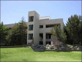
Cerro Coso Community College is a public community college in the Eastern Sierra region of Southern California. It was established in 1973 as a separate college within the Kern Community College District. The college offers traditional and online courses and two-year degrees. The college serves an area of approximately 18,000-square-miles. Cerro Coso has five instructional sites: Eastern Sierra Center Bishop and Mammoth Lakes, Indian Wells Valley, Kern River Valley, and South Kern. The college also has an Incarcerated Student Education Program in two locations, the California City Correctional Facility and Tehachapi California Correctional Institution.

Scovern Hot Springs is a thermal spring system, and former settlement in the Kern River Valley of the Southern Sierra Nevada, in Kern County, California.
Quartzburg is a former settlement in Kern County, California. It was located 1 mile (1.6 km) north of the original site of Kernville, now inundated by Isabella Lake, except at low water. In 1873, Quartzburg was founded as a mining camp after gold production increased nearby.
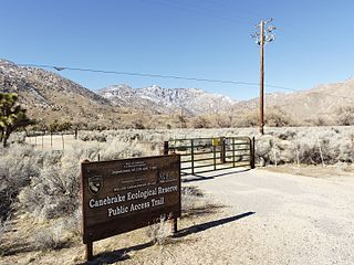
Canebrake Ecological Reserve is a 6,700-acre (27 km2) nature reserve in the South Fork Valley of Kern County, 20 miles (32 km) east of Lake Isabella, California. It is located in the Southern Sierra Nevada region.
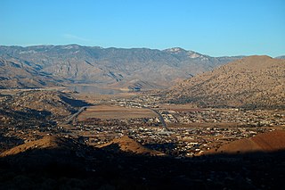
The Kern River Valley is a valley and region of the Southern Sierra Nevada, in Kern County, California.
Tillie Creek is a tributary of the North Fork of the Kern River, in the Southern Sierra Nevada, Kern County, California.
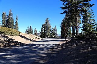
Sherman Pass is a mountain pass in California on the Kern Plateau in the Sequoia National Forest near the southern tip of the Sierra Nevada. It is traversed by Sherman Pass Road, which runs from Kern River Highway (M-99) at the North Fork of the Kern River on the west to Kennedy Meadow Road on the east.
The French Fire was a wildfire that burned 26,535 acres (10,738 ha) near Shirley Meadows west of Lake Isabella in Kern County, California in the United States during the 2021 California wildfire season. The fire was initially reported on Wednesday, August 18, 2021, and ended around October 24, 2021. The fire threatened the communities of Shirley Meadows, Alta Sierra and Wofford Heights. The fire is currently 99% contained and has also reportedly destroyed some 17 structures, including 9 residences. The cause of the fire remains under investigation.


