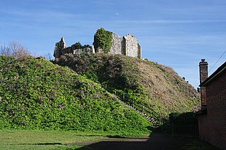
Orford Castle is a castle in Orford in the English county of Suffolk, 12 miles (19 km) northeast of Ipswich, with views over Orford Ness. It was built between 1165 and 1173 by Henry II of England to consolidate royal power in the region. The well-preserved keep, described by historian R. Allen Brown as "one of the most remarkable keeps in England", is of a unique design and probably based on Byzantine architecture. The keep stands within the earth-bank remains of the castle's outer fortifications.

Denton is a village and civil parish in the county of Norfolk, England. At the 2001 census it had a population of 352 inhabitants living in 149 dwellings, reducing to a population of 326 at the 2011 census,. Located on the southern edge of the county, Denton has an area of 10.11 km2 (3.90 sq mi). The nearest towns are Harleston and Bungay. To the south lies the river Waveney, to the west Alburgh, to the north Topcroft and Bedingham and to the east Earsham.
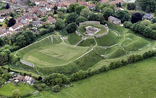
Castle Acre Castle and town walls are a set of ruined medieval defences built in the village of Castle Acre, Norfolk. The castle was built soon after the Norman Conquest by William de Warenne, the Earl of Surrey, at the intersection of the River Nar and the Peddars Way. William constructed a motte-and-bailey castle during the 1070s, protected by large earthwork ramparts, with a large country house in the centre of the motte. Soon after, a small community of Cluniac monks were given the castle's chapel in the outer bailey; under William, the second earl, the order was given land and estates to establish Castle Acre Priory alongside the castle. A deer park was created nearby for hunting.

Skipsea Castle was a Norman motte and bailey castle near the village of Skipsea, East Riding of Yorkshire, England. Built around 1086 by Drogo de la Beuvrière, apparently on the remains of an Iron Age mound, it was designed to secure the newly conquered region, defend against any potential Danish invasion and control the trade route across the region leading to the North Sea. The motte and the bailey were separated by Skipsea Mere, an artificial lake that was linked to the sea during the medieval period via a navigable channel. The village of Skipsea grew up beside the castle church, and the fortified town of Skipsea Brough was built alongside the castle around 1160 to capitalise on the potential trade.
Abinger Castle is an earthwork motte and bailey that was topped with a small wooden fortress. It is located in Abinger Common, between Guildford and Dorking in Surrey, England.
Eye Castle is a motte and bailey medieval castle with a prominent Victorian addition in the town of Eye, Suffolk. Built shortly after the Norman conquest of England in 1066, the castle was sacked and largely destroyed in 1265. Sir Edward Kerrison built a stone house on the motte in 1844: the house later decayed into ruin, becoming known as Kerrison's Folly in subsequent years.

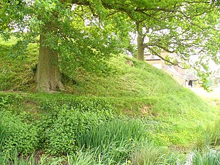
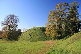
Haughley Castle was a medieval castle situated in the village of Haughley, some 4 kilometres (2.5 mi) north-west of the town of Stowmarket, Suffolk. Prominent historians such as J. Wall consider it "the most perfect earthwork of this type in the county," whilst R. Allen Brown has described it as "one of the most important" castle sites in East Anglia.
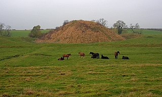
Thetford Castle is a medieval motte and bailey castle in the market town of Thetford in the Breckland area of Norfolk, England. The first castle in Thetford, a probable 11th-century Norman ringwork called Red Castle, was replaced in the 12th century by a much larger motte and bailey castle on the other side of the town. This new castle was largely destroyed in 1173 by Henry II, although the huge motte, the second largest man-made mound in England, remained intact. The motte, recognised as a scheduled monument, now forms part of a local park, and the remains are known variously as Castle Hill, Castle Mound and Military Parade.

Pilsbury Castle was a Norman castle in Derbyshire near the present-day village of Pilsbury, overlooking the River Dove.

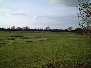
Totternhoe Knolls is a 13.1 hectare Site of Special Scientific Interest (SSSI) in Totternhoe in Bedfordshire. It is also a local nature reserve, and part of the Chilterns Area of Outstanding Natural Beauty. The site is owned by Central Bedfordshire Council and leased to the National Trust. Most of the site is maintained jointly by the National Trust and the Wildlife Trust for Bedfordshire, Cambridgeshire and Northamptonshire (WTBCN), and is part of the WTBCN Totternhoe nature reserve, which also includes Totternhoe Chalk Quarry and Totternhoe Stone Pit. The SSSI also includes Totternhoe Castle, the earthworks of a Norman motte-and-bailey castle which is a Scheduled monument.
Bishopton Castle was a medieval castle in Bishopton village, County Durham, England. The surviving motte is a Scheduled Ancient Monument.

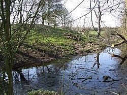
Denham Castle, also known as Castle Holes, is a medieval motte and bailey castle near the village of Gazeley, Suffolk, England. The castle was also known as Desning Castle at the time of building and occupation.

Lidgate Castle is a medieval motte and bailey castle in the village of Lidgate, Suffolk, England, built to an unusual quadrangular design.
Ballands Castle was a castle near the village of Penselwood, Somerset, England.
Locking Castle was a castle that once stood on Carberry Hill near the site of RAF Locking in Locking in the North Somerset district of Somerset, England. It has been scheduled as an ancient monument.
Down End Castle, also known as Downend Castle, Chisley Mount or Chidley Mount, was a motte-and-bailey castle at Down End, north of Dunball in the parish of Puriton, Somerset, England. It has been designated as a Scheduled Ancient Monument.
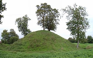
Middleton Mount, also called Middleton Motte and Middleton Castle, is the remains of a medieval castle situated in the village of Middleton, in Norfolk, England.

There are over 670 scheduled monuments in the ceremonial county of Somerset in South West England. The county consists of a non-metropolitan county, administered by Somerset County Council, which is divided into five districts, and two unitary authorities. The districts of Somerset are West Somerset, South Somerset, Taunton Deane, Mendip and Sedgemoor. The two administratively independent unitary authorities, which were established on 1 April 1996 following the breakup of the county of Avon, are North Somerset and Bath and North East Somerset. These unitary authorities include areas that were once part of Somerset before the creation of Avon in 1974.