Derma, Mississippi

Last updated

Derma, Mississippi
DermaMSSign.jpg
Flag of Derma, Mississippi.png
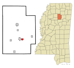
Calhoun County Mississippi Incorporated and Unincorporated areas Derma Highlighted.svg
Location of Derma, Mississippi
Usa edcp location map.svg
Red pog.svg
Derma, Mississippi
Location in the United States
Coordinates: 33°51′24″N89°17′11″W / 33.85667°N 89.28639°W / 33.85667; -89.28639
Country United States
State Mississippi
County Calhoun
Area
[1]
  Total1.77 sq mi (4.59 km2)
  Land1.77 sq mi (4.59 km2)
  Water0.00 sq mi (0.00 km2)
Elevation
292 ft (89 m)
Population
 (2020)
  Total957
  Density540.37/sq mi (208.65/km2)
Time zone UTC-6 (Central (CST))
  Summer (DST) UTC-5 (CDT)
ZIP code
38839
Area code 662
FIPS code 28-18940
GNIS feature ID0669237

Derma is a town in Calhoun County, Mississippi, United States. The population was 1,025 at the 2010 census. [2]

Contents

Geography

Derma is located in south-central Calhoun County at 33°51′24″N89°17′11″W / 33.85667°N 89.28639°W / 33.85667; -89.28639 (33.856531, -89.286384). [3] It is bordered to the west by Calhoun City. Mississippi Highway 8 runs through the center of town, leading west into Calhoun City and east 6 miles (10 km) to Vardaman.

According to the United States Census Bureau, the town has a total area of 1.8 square miles (4.6 km2), all land. [2] The Yalobusha River, a tributary of the Yazoo River, passes about one mile south of the town.

Demographics

Historical population
CensusPop.Note
1910 383
1920 317−17.2%
1930 45643.8%
1940 4774.6%
1950 4943.6%
1960 57817.0%
1970 66014.2%
1980 79320.2%
1990 95920.9%
2000 1,0236.7%
2010 1,0250.2%
2020 957−6.6%
U.S. Decennial Census [4]

2020 census

Derma Racial Composition [5]
RaceNum.Perc.
White 31332.71%
Black or African American 56058.52%
Native American 40.42%
Other/Mixed 293.03%
Hispanic or Latino 515.33%

As of the 2020 United States Census, there were 957 people, 465 households, and 297 families residing in the town.

2000 census

As of the census [6] of 2000, there were 1,023 people, 374 households, and 287 families residing in the town. The population density was 909.3 inhabitants per square mile (351.1/km2). There were 397 housing units at an average density of 352.9 per square mile (136.3/km2). The racial makeup of the town was 57.67% African American, 41.45% White, 0.10% Native American, 0.10% Pacific Islander, 0.10% from other races, and 0.59% from two or more races. Hispanic or Latino of any race were 0.39% of the population.

There were 374 households, out of which 40.6% had children under the age of 18 living with them, 47.1% were married couples living together, 24.6% had a female householder with no husband present, and 23.0% were non-families. 22.2% of all households were made up of individuals, and 10.4% had someone living alone who was 65 years of age or older. The average household size was 2.74 and the average family size was 3.20.

In the town, the population was spread out, with 31.3% under the age of 18, 8.8% from 18 to 24, 28.8% from 25 to 44, 19.5% from 45 to 64, and 11.6% who were 65 years of age or older. The median age was 32 years. For every 100 females, there were 80.1 males. For every 100 females age 18 and over, there were 74.0 males.

The median income for a household in the town was $22,344, and the median income for a family was $31,000. Males had a median income of $22,130 versus $16,364 for females. The per capita income for the town was $14,274. About 17.6% of families and 18.6% of the population were below the poverty line, including 23.8% of those under age 18 and 20.3% of those age 65 or over.

Education

Derma is served by the Calhoun County School District.

Notable natives

Related Research Articles

<span class="mw-page-title-main">Pontotoc County, Mississippi</span> County in Mississippi, United States

Pontotoc County is a county located in the U.S. state of Mississippi. As of the 2020 census, the population was 31,184. Its county seat is Pontotoc. It was created on February 9, 1836, from lands ceded to the United States under the Chickasaw Cession. Pontotoc is a Chickasaw word meaning "land of hanging grapes". The original Natchez Trace and the current-day Natchez Trace Parkway both pass through the southeast corner of Pontotoc County.

<span class="mw-page-title-main">Calhoun County, Mississippi</span> County in Mississippi, United States

Calhoun County is a county located in the U.S. state of Mississippi. As of the 2020 census, the population was 13,266. Its county seat is Pittsboro. The county is named after John C. Calhoun, the U.S. Vice President and U.S. Senator from South Carolina.

<span class="mw-page-title-main">Hampton, Arkansas</span> Town in Arkansas, United States

Hampton is a town in Calhoun County, Arkansas, United States. The population was 1,181 according to the 2020 United States Census. The town is the county seat of Calhoun County.

<span class="mw-page-title-main">Rosston, Arkansas</span> Town in Arkansas, United States

Rosston is a town in south-central Nevada County, Arkansas, United States. The population was 265 at the 2000 census. It is part of the Hope Micropolitan Statistical Area.

<span class="mw-page-title-main">Hardin, Illinois</span> Village in Illinois, United States

Hardin is a village and county seat of Calhoun County, Illinois, United States. The population was 801 at the 2020 census, down from 967 at the 2010 census.

<span class="mw-page-title-main">Panola, Illinois</span> Village in Illinois, United States

Panola is a village in Woodford County, Illinois, United States. The population was 45 at the 2010 census. It is part of the Peoria, Illinois Metropolitan Statistical Area.

<span class="mw-page-title-main">Hardinsburg, Indiana</span> Town in Indiana, United States

Hardinsburg is a town in Posey Township, Washington County, in the U.S. state of Indiana. The population was 222 at the 2020 census.

<span class="mw-page-title-main">Renova, Mississippi</span> Town in Mississippi, United States

Renova is a town in Bolivar County, Mississippi, United States.Per the 2020 census, the population was 676. The community was founded by African Americans and remains predominantly African American.

<span class="mw-page-title-main">Bruce, Mississippi</span> Town in Mississippi, United States

Bruce is a town situated along the Skuna River in Calhoun County, Mississippi, United States. As of the 2020 census, it had a population of 1,707.

<span class="mw-page-title-main">Calhoun City, Mississippi</span> Town in Mississippi, United States

Calhoun City is a town in Calhoun County, Mississippi, United States. The population was 1,774 at the 2010 census.

<span class="mw-page-title-main">Vardaman, Mississippi</span> Town in Mississippi, United States

Vardaman is a town in Calhoun County, Mississippi. The town's population was 1,316 at the time of the 2010 United States Census.

<span class="mw-page-title-main">French Camp, Mississippi</span> Town in Mississippi, United States

French Camp is a town in Choctaw County, Mississippi, United States. The population was 174 at the 2010 census, down from 393 in 2000.

<span class="mw-page-title-main">Sidon, Mississippi</span> Town in Mississippi, United States

Sidon is a town in Leflore County, Mississippi, United States. The population was 509 at the 2010 census. It is part of the Greenwood, Mississippi micropolitan area.

<span class="mw-page-title-main">Decatur, Mississippi</span> Town in Mississippi, United States

Decatur is a town in and the county seat of Newton County, Mississippi. The population was 1,841 at the 2010 census. This town is named after war hero Stephen Decatur, Jr.

<span class="mw-page-title-main">Big Creek, Mississippi</span> Village in Mississippi, United States

Big Creek is a village in Calhoun County, Mississippi, United States. The population was 154 at the 2010 census.

<span class="mw-page-title-main">Pittsboro, Mississippi</span> Village in Mississippi, United States

Pittsboro is a village in Calhoun County, Mississippi, United States. The population was 202 at the 2010 census. It is the county seat of Calhoun County.

<span class="mw-page-title-main">Grantsville, West Virginia</span> Town in West Virginia, United States

Grantsville is a town in Calhoun County, West Virginia, United States. The population was 482 at the 2020 census. It is the county seat of Calhoun County. The town was established along the Little Kanawha River in 1865 and named for Ulysses S. Grant. Grantsville is home to Wayne Underwood Park, which includes a .25-mile-long (0.40 km) walking trail, and to the annual West Virginia Wood Festival.

<span class="mw-page-title-main">Auburn, West Virginia</span> Town in West Virginia, United States

Auburn is a town in Ritchie County, West Virginia, United States. The population was 80 at the 2020 census.

Dallas is a town in Barron County in the U.S. state of Wisconsin. As of the 2010 census, the town had a population of 565. The Village of Dallas is within the town.

Wilton is a town in Monroe County, Wisconsin, United States. The population was 925 at the 2000 census. The Village of Wilton is located partially within the town.

References

  1. "2020 U.S. Gazetteer Files". United States Census Bureau. Retrieved July 24, 2022.
  2. 1 2 "Geographic Identifiers: 2010 Demographic Profile Data (G001): Derma town, Mississippi". U.S. Census Bureau, American Factfinder. Archived from the original on February 12, 2020. Retrieved October 2, 2014.
  3. "US Gazetteer files: 2010, 2000, and 1990". United States Census Bureau. February 12, 2011. Retrieved April 23, 2011.
  4. "Census of Population and Housing". Census.gov. Retrieved June 4, 2015.
  5. "Explore Census Data". data.census.gov. Retrieved December 8, 2021.
  6. "U.S. Census website". United States Census Bureau . Retrieved January 31, 2008.
  7. "Glenn Hardin". USA Track & Field. Retrieved November 2, 2017.