
Derry, officially Londonderry, is the largest city in County Londonderry, the second-largest in Northern Ireland and the fifth-largest on the island of Ireland. The old walled city lies on the west bank of the River Foyle, which is spanned by two road bridges and one footbridge. The city now covers both banks.
County Londonderry, also known as County Derry, is one of the six counties of Northern Ireland, one of the thirty-two counties of Ireland and one of the nine counties of Ulster. Before the partition of Ireland, it was one of the counties of the Kingdom of Ireland from 1613 onward and then of the United Kingdom after the Acts of Union 1800. Adjoining the north-west shore of Lough Neagh, the county covers an area of 2,118 km2 (818 sq mi) and today has a population of about 252,231.
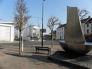
Strabane is a town in County Tyrone, Northern Ireland.

Castlederg is a town in County Tyrone, Northern Ireland. It lies on the River Derg and is near the border with County Donegal, Ireland. It stands in the townlands of Castlesessagh and Churchtown, in the historic barony of Omagh West and the civil parish of Urney. The village has a ruined castle and two ancient tombs known as the Druid's Altar and Todd's Den. It had a population of 2,980 people at the 2021 census.

Foyle is a constituency in Northern Ireland covering Derry, represented in the House of Commons of the UK Parliament. Its current Member of Parliament (MP) has been Colum Eastwood of the SDLP since 2019.

East Londonderry is a constituency in Northern Ireland represented in the House of Commons of the UK Parliament. Its current Member of Parliament (MP) has been Gregory Campbell of the DUP since 2001.
Derry City Council was the local government authority for the city of Derry in Northern Ireland. It merged with Strabane District Council in April 2015 under local government reorganisation to become Derry and Strabane District Council.
Strabane District Council was a local council in County Tyrone, Northern Ireland established by the Local Government Act 1972. It merged with Derry City Council on 1 April 2015 under local government reorganisation in Northern Ireland to become Derry and Strabane District Council.

Donemana is a village in County Tyrone, Northern Ireland. It is 7 miles or 11 kilometres north-east of Strabane, on the banks of the Burn Dennett and at the foothills of the Sperrins. In 2001, it was the largest of the thirteen villages in the former Strabane District Council area and it had a population of 586 in the Census that year.
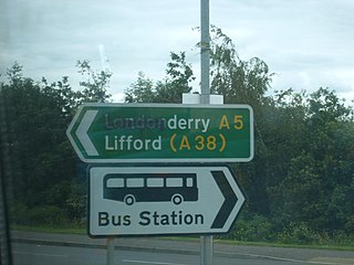
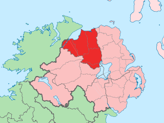
The names of the city and county of Derry or Londonderry in Northern Ireland are the subject of a naming dispute between Irish nationalists and unionists. Generally, although not always, nationalists favour using the name Derry, and unionists Londonderry. Legally, the city and county are called "Londonderry", while the local government district containing the city is called "Derry City and Strabane". The naming debate became particularly politicised at the outset of the Troubles, with the mention of either name acting as a shibboleth used to associate the speaker with one of Northern Ireland's two main communities. The district of Derry and Strabane was created in 2015, subsuming a district created in 1973 with the name "Londonderry", which changed to "Derry" in 1984.

Artigarvan is a village and townland in County Tyrone, Northern Ireland.
Park is a small village in County Londonderry, Northern Ireland. It sits on the banks of the River Faughan and the foothills of the Sperrin Mountains near the village of Claudy. The village adjoins the 120-hectare Learmount Forest; Learmount Castle is situated in the forest, and has stood for hundreds of years.
Derek Robert Hussey is an Ulster Unionist Party (UUP) politician, serving as a Derry and Strabane Councillor for the Derg DEA since 2020, having previously served between 2014 and 2019. Hussey was a Member of the Northern Ireland Assembly (MLA) for West Tyrone from 1998 to 2007.

Alderman Maurice Devenney is a Democratic Unionist Party (DUP) politician who was a Derry and Strabane Councillor for the Sperrin DEA from 2019 to 2023. Devenney also briefly served as a Member of the Northern Ireland Assembly (MLA) for Foyle from 2014 to 2015.

The 2023 election to Derry City and Strabane District Council was held on 18 May 2023, alongside other local elections in Northern Ireland, two weeks after local elections in England. The Northern Ireland elections were delayed by 2 weeks to avoid overlapping with the coronation of King Charles III.

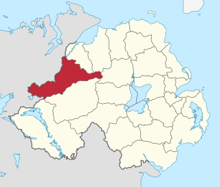
Sperrin is one of the seven district electoral areas (DEA) in Derry and Strabane, Northern Ireland. The district elects seven members to Derry and Strabane District Council and contains the wards of Artigarvan, Ballycolman, Dunnamanagh, Glenelly Valley, Park, Strabane North and Strabane West. Sperrin forms part of the West Tyrone constituencies for the Northern Ireland Assembly and UK Parliament.

Ballyarnett is one of the seven district electoral areas (DEA) in Derry and Strabane, Northern Ireland. The district elects six members to Derry and Strabane District Council and contains the wards of Carn Hill, Culmore, Galliagh, Shantallow, Shantallow East and Skeoge. Ballyarnett forms part of the Foyle constituencies for the Northern Ireland Assembly and UK Parliament.

Foyleside is one of the seven district electoral areas (DEA) in Derry and Strabane, Northern Ireland. The district elects five members to Derry and Strabane District Council and contains the wards of Ballymagroaty, Foyle Springs, Madam's Bank, Northland and Springtown. Ballyarnett forms part of the Foyle constituencies for the Northern Ireland Assembly and UK Parliament.

Faughan is one of the seven district electoral areas (DEA) in Derry and Strabane, Northern Ireland. The district elects five members to Derry and Strabane District Council and contains the wards of Claudy, Eglinton, Enagh, New Buildings and Slievekirk. Faughan forms part of the Foyle constituencies for the Northern Ireland Assembly and UK Parliament.
Londonderry Area A, called Derry Area A from 1984, was one of the five district electoral areas in Derry, Northern Ireland which existed from 1973 to 1985. The district elected six members to Londonderry City Council, and formed part of the Londonderry constituencies for the Northern Ireland Assembly and UK Parliament.
