Eglinton, County Londonderry

Last updated

Eglinton
Eglinton near the main street.jpg
United Kingdom Northern Ireland adm location map.svg
Red pog.svg
Eglinton
Location within Northern Ireland
Population3,571 (2021 Census)
  Belfast 58 mi (93 km)
District
County
Country Northern Ireland
Sovereign state United Kingdom
Post town LONDONDERRY [2]
Postcode district BT47
Dialling code 028
UK Parliament
List of places
UK
Northern Ireland
County Londonderry
55°02′25″N7°10′30″W / 55.040397°N 7.175047°W / 55.040397; -7.175047

Eglinton is a village in County Londonderry, Northern Ireland. It lies 5.5 miles (8.9 km) east-north-east of Derry, to which it serves as a sleeper village, and 9.5 miles (15.3 km) west-south-west of Limavady. It resides within Derry and Strabane district. The City of Derry Airport, also known as Eglinton Aerodrome and formerly as Londonderry Eglinton Airport, [3] [4] lies a short distance from the village.

Contents

Eglinton still has an elegant church, former market house, trees around a green and four oaks which started life in Windsor Great Park. [5] The River Muff flows through the village with the afforested Muff Glen being situated just south of the village. [6] At an embankment of Lough Foyle, birdwatchers can find the feeding ground of many seabirds and waders on the mud flats at low tide.

History

The village of Eglinton was originally known as (the) Muff, and alternatively as (the) Moigh or Mough. [7] These come from Irish Magh / an Mhagh 'the plain' [8] [7] and were the names of the townland in which the village began. [7] The village was founded in 1619 by the Grocers' Company of London. As part of the Plantation of Ulster, James I had granted a large area (15,900 acres) of Faughanvale parish to the Grocers in 1609. The Grocers did not farm it themselves but leased this area to Edward Rone of Essex in 1615 with the stipulation that he built a bawn and 12 houses by 1619. The yearly rent being £116-13s-4d. Rone died in 1618 but his brother-in-law Robert Harrington took over and by 1619 a castle and bawn, as well as eight houses were erected in the townland of Muff (now Eglinton) and by 1622 the stipulated building was completed

The castle (really a castellated house and bawn with 4 flanker towers) was besieged in 1641 during the English Civil War by the insurgents under Colonel McDonnell and defended by the garrison during the winter of that year. It was relieved the following summer by troops from Derry but it afterwards fell into the hands of the parliamentarians by whom it was dismantled. During the Siege of Derry, the castle was briefly occupied by troops of King James while they were foraging for supplies.

Eglinton Parish Church St Canices Church of Ireland.jpg
Eglinton Parish Church
Faughanvale Presbyterian Church Faughanvale Presbyterian Church.jpg
Faughanvale Presbyterian Church

The ruins were standing and occupied until 1823 when the present Rectory was built on the site. The only remains of the castle today being the cellars under the rectory.

The Church of Ireland was represented within the village by the Parish Church of Faughanvale which was built in 1626. It was later superseded by a new Parish Church constructed in 1821 with the ruins of the old church being extant within the adjacent graveyard.

The Presbyterian Church was represented in the village with the building of the first church in 1730. Prior to this, the congregation formed part of the Glendermott Congregation in the city of Derry. The original church was built in the townland of Tullanee just east of the village. The existing much larger church, Faughanvale Presbyterian Church, was built in 1894 with the help of donations from fellow citizens of the congregation who had some time earlier emigrated to the United States. Nothing remains of the original church which stood in what is now the Presbyterian Church graveyard immediately to the rear of the new church.

There were several other places called Muff at the time, especially one nearby in Donegal which created much confusion. The residents of the village resolved to afford of the opportunity to change the name. Therefore, on 19 August 1858, the village of Muff became Eglinton in honour of the Lord Lieutenant of Ireland, the 13th Earl of Eglinton who was visiting the nearby Templemoyle Agricultural School at the time. The school was opened in 1826 aimed at teaching new agricultural methods but eventually closed in 1865. The building remained disused for many years before being converted into a nursing home in the 1990s.

Main Street looking east Main Street Eglinton 01.JPG
Main Street looking east

Tom Gallaher (1840–1927), the miller's son of Templemoyle, was the founder of the famous tobacco firm of Gallahers, now the Gallaher Group. His relatives lived in The Glen House in the centre of Eglinton village until the 1950s.

One of the oldest buildings, if not the oldest standing today, is Foyle Park House. Foyle Park was built in 1813 by David Babington who rented his land from the Worshipful Company of Grocers. The mansion was built when Babington started to make land improvements in the west of the village between 1805 and 1836 when he planted 172,000 trees, mainly to shelter the house. Babington used the house as a literary school for a while. When Babington's lease expired, the Grocers didn't renew the lease so the Literary School then closed its doors and Foyle Park then became the new Grocers' Hall. It was used as the Grocers' Hall until the 1870s when James Davidson, a customs and exports worker, bought the entire village from the Grocers' Company. This included the Foyle Park Estate. Davidson lived at Foyle Park and the Manor House. His son, James William Davidson then lived in Foyle Park after him. Davidson's grandson sold Foyle Park to H. Whiteside in 1920 and the house fell out of the Davidson family. The house was re-acquired by the family when Lt. Col. Kenneth Davidson bought the house back in the 1960s. The house remained with the family until it was finally sold off in 2011, after over 100 years of ownership.

Another of the oldest buildings today is the Erasmus Smith schoolhouse built in 1814 beside the old national school of 1886 both now private residences. The Grocers did not resume active management of the estate until 1823 when they rebuilt the village. Among the buildings erected by the company in 1823-5 were the Rectory, a Courthouse or Market house ( an unusually well designed building by Nicholson which included a dispensary (the wall plaques outside the former courthouse are the Grocers and David Babingtons coat of arms)), a Manor house for the Grocers agent and the Glen house. All of which are still to be seen today. They also built a row of cottages for local widows which was known until quite recently as Widow's Row (now renamed Cottage Row) and tradesmen's houses along Main Street. The millers house opposite the Happy Landing public house became the old R.I.C. barracks until the present police station was built. The Grocers sold the village in 1874 to James Davidson from Brechin, Scotland; his descendants still reside in the manor house to this day.

During the Second World War RAF Eglinton was home to many Royal Air Force and later to Royal Navy personnel. Many old buildings currently in a state of disrepair, evidence their presence, and can still be seen dotted around the outskirts of the village. The airfield was a major airfield for flights over the North Atlantic, their tasks included searching for U-boats and acting as air cover for convoys. Several aircraft crashed in the vicinity of the village and the nearby airfield with several pilots and aircrew being buried locally in the Parish Church and Presbyterian Church graveyards.

Transport

Demography

National Identity of Eglinton residents (2021) [10] [11] [12]
NationalityPer cent
Irish
41.3%
Northern Irish
34.6%
British
33.9%

2021 Census

On Census day (21 March 2021) there were 3,571 people living in Eglinton. [13] Of these:

2011 Census

On Census day (27 March 2011) there were 3,679 people (in 1,315 households) living in Eglinton [15] an increase of 16% on the 2001 Census population of 3,165. [16] Of these:

Notable people

See also

Related Research Articles

<span class="mw-page-title-main">Derry</span> City in Northern Ireland

Derry, officially Londonderry, is the largest city in County Londonderry, the second-largest in Northern Ireland and the fifth-largest on the island of Ireland. The old walled city lies on the west bank of the River Foyle, which is spanned by two road bridges and one footbridge. The city now covers both banks.

<span class="mw-page-title-main">County Londonderry</span> County in Northern Ireland

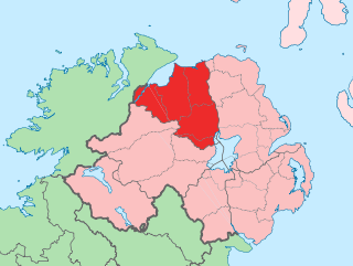
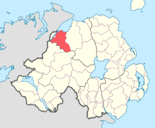
County Londonderry, also known as County Derry, is one of the six counties of Northern Ireland, one of the thirty-two counties of Ireland and one of the nine counties of Ulster. Before the partition of Ireland, it was one of the counties of the Kingdom of Ireland from 1613 onward and then of the United Kingdom after the Acts of Union 1800. Adjoining the north-west shore of Lough Neagh, the county covers an area of 2,118 km2 (818 sq mi) and today has a population of about 252,231.

<span class="mw-page-title-main">Omagh</span> County town of County Tyrone, Northern Ireland

Omagh is the county town of County Tyrone, Northern Ireland. It is situated where the rivers Drumragh and Camowen meet to form the Strule. Northern Ireland's capital city, Belfast, is 68 miles (109.5 km) to the east of Omagh, and Derry is 34 miles (55 km) to the north.

<span class="mw-page-title-main">Limavady</span> Town in County Londonderry, Northern Ireland

Limavady is a market town in County Londonderry, Northern Ireland, with Binevenagh as a backdrop. Lying 17 miles (27 km) east of Derry and 14 miles (23 km) southwest of Coleraine, Limavady had a population of 11,279 people at the 2021 Census. In the 40 years between 1971 and 2011, Limavady's population nearly doubled. Limavady is within Causeway Coast and Glens Borough.

<span class="mw-page-title-main">Strabane</span> Town in County Tyrone, Northern Ireland

Strabane is a town in County Tyrone, Northern Ireland.

<span class="mw-page-title-main">Dungiven</span> Town in County Londonderry, Northern Ireland

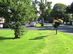
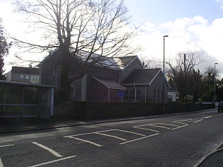
Dungiven is a small town, townland and civil parish in County Londonderry, Northern Ireland. It is near the main A6 Belfast to Derry road, which bypasses the town. It lies where the rivers Roe, Owenreagh and Owenbeg meet at the foot of the 1,525 ft (465 m) Benbradagh. Nearby is the Glenshane Pass, where the road rises to over 1,000 ft (300 m). It had a population of 3,346 people in the 2021 Census. It is within Causeway Coast and Glens district council area.

<span class="mw-page-title-main">Moneymore</span> Village in County Londonderry, Northern Ireland

Moneymore is a village and townland in County Londonderry, Northern Ireland. It had a population of 1,897 in the 2011 Census. It is situated within Mid-Ulster District. It is an example of a plantation village in Mid-Ulster built by the Drapers' Company of London.

<span class="mw-page-title-main">Draperstown</span> Village in County Londonderry, Northern Ireland

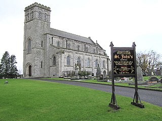
Draperstown is a village in the Sperrin Mountains in County Londonderry, Northern Ireland. It is situated in the civil parish of Ballinascreen and is part of Mid-Ulster district. It is also part of the Church of Ireland parish of Ballynascreen and the Catholic parish of Ballinascreen, and within the former barony of Loughinsholin.

<span class="mw-page-title-main">Maghera</span> Town in County Londonderry, Northern Ireland

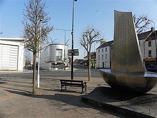
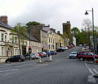
Maghera is a small town at the foot of the Glenshane Pass in Northern Ireland. Its population was 4,235 in the 2021 Census. Formerly in the barony of Loughinsholin within the historic County Londonderry, it is today in the local-government district of Mid-Ulster.

<span class="mw-page-title-main">Ballykelly, County Londonderry</span> Village in County Londonderry, Northern Ireland

Ballykelly is a village and townland in County Londonderry, Northern Ireland. It lies 3 miles (4.8 km) west of Limavady on the main Derry to Limavady A2 road and is 15 miles (24 km) east of Derry. It is designated as a Large Village and in 2011 the population of Ballykelly was 2,107. It lies within Causeway Coast and Glens district.

<span class="mw-page-title-main">Castlerock</span> Seaside village in County Londonderry, Northern Ireland

Castlerock is a seaside village in County Londonderry, Northern Ireland. It is five miles west of Coleraine, and part of Causeway Coast and Glens district. It is very popular with summer tourists, with numerous apartment blocks and two caravan sites. Castlerock Golf Club has both 9-hole and 18-hole links courses bounded by the beach, the River Bann and the Belfast to Derry railway line. The village had a population of 1,155 people at the 2021 census, and is where near by village Articlave F.C play their home games.

<span class="mw-page-title-main">Newbuildings</span> Village in County Londonderry, Northern Ireland

Newbuildings or New Buildings is a large village in County Londonderry, Northern Ireland. It lies close to the banks of the River Foyle and 3 mi (5 km) south of the city of Derry. It had a population of 3,381 in the 2011 Census. It is within Derry and Strabane district.

<span class="mw-page-title-main">Culmore</span> Village near Derry, Northern Ireland

Culmore is a village and townland in Derry, County Londonderry, Northern Ireland. It is at the mouth of the River Foyle. In the 2011 Census it had a population of 3,465 people. It is situated within Derry and Strabane district.

<span class="mw-page-title-main">Greysteel</span> Village in County Londonderry, Northern Ireland

Greysteel or Gresteel is a village in County Londonderry, Northern Ireland. It lies 9 miles (14 km) to the east of Derry and 7 miles (11 km) to the west of Limavady on the main A2 coast road between Limavady and Derry, overlooking Lough Foyle. It is designated as a Large Village and in the 2001 Census it had a population of 1,229 people, an increase of almost 20% compared to 1991. It is situated within Causeway Coast and Glens district.

<span class="mw-page-title-main">Richhill, County Armagh</span> Village in County Armagh, Northern Ireland

Richhill is a large village and townland in County Armagh, Northern Ireland. It lies between Armagh and Portadown. It had a population of 2,738 people in the 2021 Census.

<span class="mw-page-title-main">Quigley's Point</span> Village in County Donegal, Ireland

Quigley's Point is a village in County Donegal, Ireland. Located on the eastern shores of Inishowen and overlooking Lough Foyle, the village is sometimes known locally as "Carrowkeel" as it is in a townland of that name. To the south is the city of Derry and to the north lie the villages of Moville and Greencastle. A car ferry links Greencastle with Magilligan during the summer. The river Cabry, which flows through the area, is spanned by a late-18th century bridge at Quigley's Point.

<span class="mw-page-title-main">Mullaghbawn</span> Village in County Armagh, Northern Ireland

Mullaghbawn, or Mullaghbane, is a small village and townland near Slieve Gullion in County Armagh, Northern Ireland. In the 2011 Census it had a population of 596. At the 2021 Census this had risen to 642.

<span class="mw-page-title-main">Banagher, County Londonderry</span>

Banagher is a parish in County Londonderry, Northern Ireland. The parish is made up of the medieval parish of Banagher and parts of the ancient parish of Boveva and the townland of Tireighter and Park, once in the parish of Cumber. Banagher has many ancient monuments, including churches, holy wells, standing stones and chambered graves.

<span class="mw-page-title-main">Tirkeeran</span> Place in Northern Ireland, United Kingdom

Tirkeeran is a barony in County Londonderry, Northern Ireland. It connects to the north-Londonderry coastline, and is bordered by four other baronies: Keenaght to the east; Strabane Lower to the south-east; North West Liberties of Londonderry to the west; Strabane Upper to the south.

References

  1. "An Mhagh/Eglington". logainm.ie. Retrieved 13 April 2024.
  2. This is the official Post Town as defined by Royal Mail.
  3. http://www.nats-uk.ead-it.com/aip/current/ad/EGAE/EG_AD_2_EGAE_en.pdf%5B%5D
  4. "Inquiry" (PDF). Archived from the original (PDF) on 3 July 2007. Retrieved 15 January 2010.
  5. "AND CORONATIONS TOO". The Conservation Volunteers in Northern Ireland. Retrieved 4 August 2012.
  6. "Muff Glen Forest". Northern Ireland Forest Service. Retrieved 14 January 2010.[ permanent dead link ]
  7. 1 2 3 "Place Names NI - Home". placenamesni.org. Retrieved 21 April 2018.
  8. "An Mhagh/Eglington". Logainm.ie. Retrieved 21 April 2018.
  9. "Eglinton station" (PDF). Railscot - Irish Railways. Retrieved 13 October 2007.
  10. "National Identity (Irish)". NISRA. Retrieved 18 August 2023.
  11. "National Identity (Northern Irish)". NISRA. Retrieved 18 August 2023.
  12. "National Identity (British)". NISRA. Retrieved 18 August 2023.
  13. "Settlement 2015". NISRA. Retrieved 18 August 2023.
  14. "Religion or religion brought up in". NISRA. Retrieved 18 August 2023.
  15. "Census 2011 Population Statistics for Eglinton Settlement". Northern Ireland Statistics and Research Agency (NISRA). Retrieved 23 July 2019.
  16. "Census 2001 Usually Resident Population: KS01 (Settlements) - Table view". Northern Ireland Statistics and Research Agency (NISRA). p. 4. Retrieved 23 July 2019.

Sources