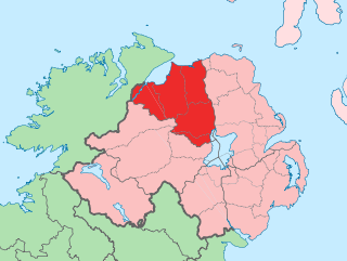
County Londonderry, also known as County Derry, is one of the six counties of Northern Ireland, one of the thirty two counties of Ireland and one of the nine counties of Ulster. Before the partition of Ireland, it was one of the counties of the Kingdom of Ireland from 1613 onward and then of the United Kingdom after the Acts of Union 1800. Adjoining the north-west shore of Lough Neagh, the county covers an area of 2,118 km2 (818 sq mi) and today has a population of about 247,132.

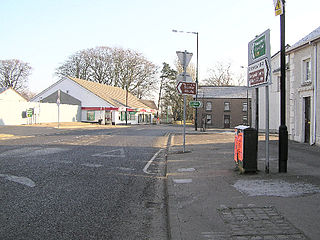
Dungiven is a small town, townland and civil parish in County Londonderry, Northern Ireland. It is near the main A6 Belfast to Derry road, which bypasses the town. It lies where the rivers Roe, Owenreagh and Owenbeg meet at the foot of the 1,525 ft (465 m) Benbradagh. Nearby is the Glenshane Pass, where the road rises to over 1,000 ft (300 m). It had a population of 3,288 people in the 2011 Census, an increase of 10% over the 2001 population of 2,993. It is within Causeway Coast and Glens district council area.

Draperstown is a village in the Sperrin Mountains in County Londonderry, Northern Ireland. It is situated in the civil parish of Ballinascreen and is part of Mid-Ulster district. It is also part of the Church of Ireland parish of Ballynascreen and the Catholic parish of Ballinascreen, and within the former barony of Loughinsholin.

Fintona, is a village and townland in County Tyrone, Northern Ireland. Its population at the 2011 Census was 1,164.

Magheralin is a village and civil parish in County Down, Northern Ireland. It is on the main A3 road between Moira and Lurgan, beside the River Lagan. It had a population of 1,337 people in the 2011 Census. The civil parish of Magheralin covers areas of County Armagh and County Down.

Ballykelly is a village and townland in County Londonderry, Northern Ireland. It lies 3 miles (4.8 km) west of Limavady on the main Derry to Limavady A2 road and is 15 miles (24 km) east of Derry. It is designated as a Large Village and in 2011 the population of Ballykelly was 2,107. It lies within Causeway Coast and Glens district.

Carnlough is a village in County Antrim, Northern Ireland. It is situated in Mid and East Antrim district, as well the historic barony of Glenarm Lower, and the civil parishes of Ardclinis and Tickmacrevan. It had a population of 1,512 people at the 2011 Census.

Drumaness is a village and townland in the Newry, Mourne and Down District Council area of County Down, Northern Ireland. It is 3 miles or 5 kilometres south of Ballynahinch, beside the main A24 Belfast to Newcastle road. It is situated in the civil parish of Magheradroll and the historic barony of Kinelarty. In the 2011 Census it had a population of 1,339 people.

Feeny is a village and townland in County Londonderry, Northern Ireland. It is between Dungiven and Claudy. In the 2011 Census it had a population of 690. Feeny lies just inside the boundary of the Sperrins Area of Outstanding Natural Beauty. It is situated within Causeway Coast and Glens district.

Kilrea is a village, townland and civil parish in County Londonderry, Northern Ireland. It gets its name from the ancient church that was located near to where the current Church of Ireland is located on Church Street looking over the town. It is near the River Bann, which marks the boundary between County Londonderry and County Antrim. In the 2011 Census it had a population of 1,678 people. It is situated within Causeway Coast and Glens district.
Strathfoyle is a village in County Londonderry, Northern Ireland It is about 5 miles (8.0 km) north east of Derry. It was newly built in different phases between the late 1950s and the early 1960s, with many new recent additions to the village, including Westlake, Butler's Wharf and Old Fort. In the 2001 Census it had a population of 1,581 people. It is within the Derry Urban Area and the Derry City Council area. The village has a small retail outlet, a Roman Catholic chapel, a library, youth club and a post office. The small retail unit was constructed in 2005 following years of under-investment in the area and pressure by local community leaders to provide more facilities for its residents.
Tobermore, Irish: An Tobar Mór) is a small village in County Londonderry, Northern Ireland named after the townland of Tobermore. The village, which has a predominantly Protestant population, lies 2.5 miles (4.0 km) south-south-west of Maghera and 5.5 miles (8.9 km) north-west of Magherafelt. Tobermore is within the civil parish of Kilcronaghan and is part of Mid-Ulster District. It was also part of the former barony of Loughinsholin.
Upperlands is a small village in County Londonderry, Northern Ireland. It is situated 3 miles north east of Maghera. It lies within the civil parish of Maghera, the historic barony of Loughinsholin, and is situated within Mid-Ulster District. In the 2011 Census it had a population of 561 people.
Derrynaflaw, also known as Dernaflaw, is a small village and townland in County Londonderry, Northern Ireland. It is about 2 kilometres west of Dungiven on the A6 Foreglen Road. It is designated as a Hamlet and in the 2001 Census it had a population of 168 people. It lies within Causeway Coast and Glens district.
Gortnahey, also transliterated as Gortnaghey, is a townland and small hamlet in County Londonderry, Northern Ireland. It is 5 km northwest of Dungiven and 13 km south of Limavady. In the 2001 Census its population was 285. It is situated within Causeway Coast and Glens district.
Broomhedge is a small village in County Antrim, Northern Ireland, near Lisburn, approximately 12 miles (19 km) southwest of Belfast. It lies within the Lisburn City Council area, and the Maghaberry electoral ward.
Glenullin was previously a rural area but has now expanded to become a small village in a valley between the villages of Garvagh, Swatragh and Dungiven, and lies in the borough of Coleraine, County Londonderry, Northern Ireland. The nearest city is Derry which is 27 miles away. 'The Glen', as it is often known, is not an officially recognised administrative division but there is a strong local identity and an active community sector. Although the area has few amenities, the local Primary school, St Patrick's & St Joseph's Federated Primary School, and St Joseph's Catholic Church have particular prominence in the life of Glenullin.

Dungiven Celtic Football Club is an intermediate-level football club playing in the Northern Ireland Intermediate League in Northern Ireland. The club is based in Dungiven, County Londonderry.
Huntstown and Littlepace is a set of modern housing developments that forms a remote suburb of Dublin city in the county of Fingal in Ireland. It was built in the townlands of Littlepace (westerly) and Huntstown (easterly) which are the southernmost townlands of the civil parish of Mulhuddart. The district is also a parish in the Blanchardstown deanery of the Roman Catholic Archdiocese of Dublin. The nearest villages in the county are Ongar, Mulhuddart and Clonsilla along with Clonee in County Meath.


