The Ulster Special Constabulary was a quasi-military reserve special constable police force in what would later become Northern Ireland. It was set up in October 1920, shortly before the partition of Ireland. The USC was an armed corps, organised partially on military lines and called out in times of emergency, such as war or insurgency. It performed this role most notably in the early 1920s during the Irish War of Independence and the 1956–1962 IRA Border Campaign.

The East Tyrone Brigade of the Provisional Irish Republican Army (IRA), also known as the Tyrone/Monaghan Brigade was one of the most active republican paramilitary groups in Northern Ireland during "the Troubles". It is believed to have drawn its membership from across the eastern side of County Tyrone as well as north County Monaghan and south County Londonderry.
Cullyhanna is a small village and townland close to Keady in County Armagh, Northern Ireland. The village extends further over the townlands of Tullynavall and Freeduff. It had a population of 306 in the 2001 Census. It is within the Newry and Mourne District Council area.

Claudy is a village and townland in County Londonderry, Northern Ireland. It lies in the Faughan Valley, 6 miles (9.7 km) southeast of Derry, where the River Glenrandal joins the River Faughan. It is situated in the civil parish of Cumber Upper and the historic barony of Tirkeeran. It is also part of Derry and Strabane district.
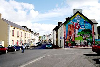
Cushendall, formerly known as Newtownglens, is a coastal village and townland in County Antrim, Northern Ireland. It is located in the historic barony of Glenarm Lower and the civil parish of Layd, and is part of Causeway Coast and Glens district.
This is a chronology of activities by the Provisional Irish Republican Army (IRA) from 1970 to 1979.

Kilrea is a village, townland and civil parish in County Londonderry, Northern Ireland. It gets its name from the ancient church that was located near where the current Church of Ireland is located on Church Street looking over the town. It is near the River Bann, which marks the boundary between County Londonderry and County Antrim. In the 2011 Census it had a population of 1,678 people. It is situated within Causeway Coast and Glens district.
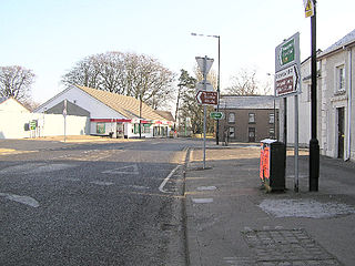
Tobermore, from Irish An Tobar Mór, meaning 'the great well') is a small village in County Londonderry, Northern Ireland named after the townland of Tobermore. The village, which has a predominantly Protestant population, lies 2.5 miles (4.0 km) south-south-west of Maghera and 5.5 miles (8.9 km) north-west of Magherafelt. Tobermore is within the civil parish of Kilcronaghan and is part of Mid-Ulster District. It was also part of the former barony of Loughinsholin.
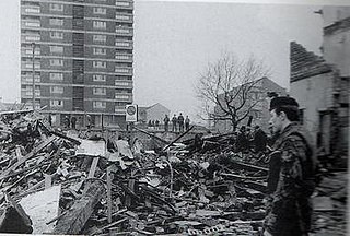
On 4 December 1971, the Ulster Volunteer Force (UVF), an Ulster loyalist paramilitary group, detonated a bomb at McGurk's Bar in Belfast, Northern Ireland, frequented by Irish Catholics–nationalists. The explosion caused the building to collapse, killing fifteen Catholic civilians—including two children—and wounding seventeen more. It was the deadliest attack in Belfast during the Troubles.

Desertmartin is a small village in County Londonderry, Northern Ireland. It is four miles from Magherafelt, at the foot of Slieve Gallion. In the 2001 Census the greater Desertmartin area had a population of 1,276. It lies within Desertmartin parish, Mid-Ulster District, and the historic barony of Loughinsholin. Neighbouring settlements include Draperstown, Magherafelt, Moneymore, and Tobermore.

Cullaville or Culloville (from Irish Baile Mhic Cullach, meaning 'MacCullach's townland' or McCulloch's ville or town is a small village and townland near Crossmaglen in County Armagh, Northern Ireland. It is the southernmost settlement in the county and one of the southernmost in Northern Ireland, straddling the Irish border. In the 2001 Census it had a population of 400 people. The village is on a busy crossroads on the main Dundalk to Castleblaney road ; three of the roads lead across the border and the fourth leads to Crossmaglen.
Antoine Mac Giolla Bhrighde, English Tony or Anthony MacBride, was a Provisional Irish Republican Army (IRA) volunteer from Desertmartin, County Londonderry, Northern Ireland. He was shot dead by the British Army in 1984 whilst engaged in an attack on the Royal Ulster Constabulary.

Ballyronan is a village and townland in County Londonderry, Northern Ireland, on the north western shore of Lough Neagh. The village is 5 miles (8 km) from Magherafelt and 12 miles (19 km) from Cookstown. It is situated within Mid-Ulster District.
The Troubles in Keady refers to incidents taking place in Keady, County Armagh, Northern Ireland during the Troubles.
This is a chronology of activities by the Provisional Irish Republican Army (IRA) from 1980 to 1989. For actions before and after this period see Chronology of Provisional Irish Republican Army actions.

The Hillcrest Bar bombing, also known as the "Saint Patrick's Day bombing", took place on 17 March 1976 in Dungannon, County Tyrone, Northern Ireland. The Ulster Volunteer Force (UVF), a loyalist paramilitary group, detonated a car bomb outside a pub crowded with people celebrating Saint Patrick's Day. Four Catholic civilians were killed by the blast—including two 13-year-old boys standing outside—and almost 50 people were injured, some severely.
On 11 August 1970, two Royal Ulster Constabulary (RUC) officers were killed by a booby-trap bomb planted under a car by the Provisional Irish Republican Army (IRA) near Crossmaglen, in County Armagh, Northern Ireland. They were the first RUC officers to be killed by republicans during the Troubles and the first security forces to be killed in South Armagh, an IRA stronghold for much of the conflict.

The Troubles of the 1920s was a period of conflict in what is now Northern Ireland from June 1920 until June 1922, during and after the Irish War of Independence and the partition of Ireland. It was mainly a communal conflict between Protestant unionists, who wanted to remain part of the United Kingdom, and Catholic Irish nationalists, who backed Irish independence. During this period, more than 500 people were killed in Belfast alone, 500 interned and 23,000 people were made homeless in the city, while approximately 50,000 people fled the north of Ireland due to intimidation. Most of the victims were Nationalists (73%) with civilians being far more likely to be killed compared to the military, police or paramilitaries.

The Stag Inn attack was a sectarian gun attack, on 30 July 1976, carried out by a group of Belfast IRA Volunteers using the cover name Republican Action Force. Four Protestants, all civilians, the youngest being 48 years old and the eldest 70, were all killed in the attack with several others being injured. Three Catholics were killed the previous day in a Loyalist bomb attack, part of a string of sectarian attacks in Northern Ireland by different paramilitary organizations.


