
Draperstown is a village in the Sperrin Mountains in County Londonderry, Northern Ireland. It is situated in the civil parish of Ballinascreen and is part of Mid-Ulster district. It is also part of the Church of Ireland parish of Ballynascreen and the Catholic parish of Ballinascreen, and within the former barony of Loughinsholin.
A townland is a small geographical division of land, historically and currently used in Ireland and in the Western Isles in Scotland, typically covering 100–500 acres (40–202 ha). The townland system is of Gaelic origin, pre-dating the Norman invasion, and most have names of Irish origin. However, some townland names and boundaries come from Norman manors, plantation divisions, or later creations of the Ordnance Survey. The total number of inhabited townlands in Ireland was 60,679 in 1911. The total number recognised by the Irish Place Names database as of 2014 was 61,098, including uninhabited townlands, mainly small islands.

Hilltown is a small village within the townland of Carcullion in County Down, Northern Ireland. Hilltown is the main village of the parish of Clonduff which contains the village and the rural areas around it at one end, and the rural enclave of Cabra at the other end of the parish. It had a population of 899 people in the 2001 Census. On 27 March 2011, the usually resident population of Hilltown was 1,709.

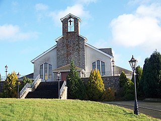
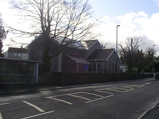
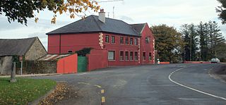
Swatragh is a small village and townland in County Londonderry, Northern Ireland. Swatragh is on the main A29 road north of Maghera, and is situated within Mid-Ulster District. The population was 438 in the 2011 Census. The village has three churches: one Roman Catholic, one Church of Ireland, and one Presbyterian. The Catholic and Church of Ireland churches are listed buildings. St John's is the local primary school.
Ballela is a small village and parish in County Down, Northern Ireland. It is about 5 miles (8.0 km) east of Banbridge, perched on top of one of the many drumlins that are common in the county. A number of prehistoric ringforts begird the village.
Newbuildings or New Buildings is a large village in County Londonderry, Northern Ireland. It lies close to the banks of the River Foyle and 3 mi (5 km) south of the city of Derry. It had a population of 3,381 in the 2011 Census. It is within Derry and Strabane district.

Ballygawley or Ballygawly is a village in County Tyrone, Northern Ireland. It is about 20 kilometres southwest of Dungannon, near the meeting of the A5 Derry–Dublin and A4 Dungannon–Enniskillen roads.

Balscaddan is a village in Fingal, Ireland. It is the most northerly village of Dublin, approx 5 km north of Balbriggan and close to the Meath border.

Ballykinler, often transcribed as Ballykinlar, is a village and civil parish in County Down, Northern Ireland. It lies 12 kilometres south west of Downpatrick, in the parish of Tyrella and Dundrum. In the 2001 Census it had a population of 348 people. It is within the Newry, Mourne and Down area and runs parallel to the Irish Sea coast. Located within the Lecale Coast Area of Outstanding Natural Beauty, the village is surrounded by low drumlins and marshes. It is also the site of a former British Army base known as Abercorn Barracks.

Ballyronan is a village and townland in County Londonderry, Northern Ireland, on the north western shore of Lough Neagh. The village is 5 miles (8 km) from Magherafelt and 12 miles (19 km) from Cookstown. It is situated within Mid-Ulster District.

Scotstown is a village in the townland of Bough in north County Monaghan, Ireland. Scotstown is located in the parish of Tydavnet, along the Monaghan Blackwater, Scotstown being the village closest to the river's source. Scotstown is centred in the townland of Bough, but extends into Carrowhatta, Teraverty, Drumdesco and Stracrunnion townlands.
Clonmore is a village and townland in County Tipperary, Ireland. It lies on the R433 road 6 km from Templemore and 7 km from Errill in County Laois. It is part of the parish of Templemore, Clonmore and Killea. The local Roman Catholic church is dedicated to Saint Ann and was built in 1832.

Ballycommon is a village and townland in County Tipperary, Ireland, on the R495 road north east of Nenagh. It is located in the barony of Ormond Lower and is part of the parish of Puckane in the Roman Catholic Diocese of Killaloe. Kildangan GAA is the local Gaelic Athletic Association club. It is not to be confused with the district and GAA team in County Offaly called Ballycommon, 5 miles east of Tullamore.
Killeen or Killean is a small village and townland in the civil parish of Killeavy, County Armagh, Northern Ireland. It lies about four miles (6.5 km) south of Newry, near the border with County Louth in the Republic of Ireland.

Kilcoo is a small village and civil parish in County Down, Northern Ireland. It lies between Rathfriland and Castlewellan and is within the Newry, Mourne and Down District Council area. Kilcoo had a population 1415 people in the 2001 Census.
Newtown is a town in County Tipperary, Ireland. It is located on the R494 regional road 7 km (4.3 mi) west of Nenagh. As of the 2016 census, the population was 309. It is in the barony of Owney and Arra. It is also part of the parish of Youghalarra in the Roman Catholic Diocese of Killaloe.

Stonetown is a small rural community spanning the townlands of Stonetown Upper and Stonetown Lower in County Louth. It lies in the parish of Louth, 10 kilometres from Dundalk, County Louth, and 11 kilometres from Carrickmacross, County Monaghan. The community consists of a small chapel, a primary school, a football field and a community centre.
Glenullin was previously a rural area but has now expanded to become a small village in a valley between the villages of Garvagh, Swatragh and Dungiven, and lies in the borough of Coleraine, County Londonderry, Northern Ireland. The nearest city is Derry which is 27 miles away. 'The Glen', as it is often known, is not an officially recognised administrative division but there is a strong local identity and an active community sector. Although the area has few amenities, the local Primary school, St Patrick's & St Joseph's Federated Primary School, and St Joseph's Catholic Church have particular prominence in the life of Glenullin.
Huntstown and Littlepace is a set of modern housing developments that forms a remote suburb of Dublin city in the county of Fingal in Ireland. It was built in the townlands of Littlepace (westerly) and Huntstown (easterly) which are the southernmost townlands of the civil parish of Mulhuddart. The district is also a parish in the Blanchardstown deanery of the Roman Catholic Archdiocese of Dublin. The nearest villages in the county are Ongar, Mulhuddart and Clonsilla along with Clonee in County Meath.


