Lisbunny, County Londonderry

Last updated

Lisbunny
Lisbunny Townland - geograph.org.uk - 420515.jpg
Lisbunny townland in 2007
United Kingdom Northern Ireland adm location map.svg
Red pog.svg
Lisbunny
Location within Northern Ireland
District
County
Country Northern Ireland
Sovereign state United Kingdom
Postcode district BT47
Dialling code 028
EU Parliament Northern Ireland
UK Parliament
NI Assembly
List of places
UK
Northern Ireland
County Londonderry
54°52′55″N7°11′10″W / 54.882°N 7.186°W / 54.882; -7.186 Coordinates: 54°52′55″N7°11′10″W / 54.882°N 7.186°W / 54.882; -7.186

Lisbunny (from Irish : Lios Buinighe, meaning "fort of the flood") [1] is a townland of 849 acres in County Londonderry, Northern Ireland, about 3 miles Claudy, near the County Tyrone/Londonderry border. It is situated within Derry and Strabane district as well as the civil parish of Cumber Upper and the historic barony of Tirkeeran. [2]

Irish language Gaelic language spoken in Ireland and by Irish people

Irish is a Goidelic language of the Celtic languages family, itself a branch of the Indo-European language family. Irish originated in Ireland and was historically spoken by Irish people throughout Ireland. Irish is spoken as a first language in substantial areas of counties Galway, Kerry, Cork and Donegal, smaller areas of Waterford, Mayo and Meath, and a few other locations, and as a second language by a larger group of habitual but non-traditional speakers across the country.

A townland is a small geographical division of land used in Ireland and in the Western Isles in Scotland. The townland system is of Gaelic origin, pre-dating the Norman invasion, and most have names of Irish Gaelic origin. However, some townland names and boundaries come from Norman manors, plantation divisions, or later creations of the Ordnance Survey. The total number of inhabited townlands in Ireland was 60,679 in 1911. The total number recognised by the Irish Place Names database as of 2014 was 61,098, including uninhabited townlands, mainly small islands.

County Londonderry Place in Northern Ireland, United Kingdom

County Londonderry, also known as County Derry, is one of the six counties of Northern Ireland. Prior to the partition of Ireland, it was one of the counties of the Kingdom of Ireland from 1613 onward and then of the United Kingdom after the Acts of Union 1800. Adjoining the north-west shore of Lough Neagh, the county covers an area of 2,074 km² and today has a population of about 247,132.

It is a rural farming area with few amenities, although it does contain a stone quarry.

Quarry A place from which a geological material has been excavated from the ground

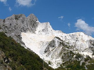
A quarry is a type of open-pit mine in which dimension stone, rock, construction aggregate, riprap, sand, gravel, or slate is excavated from the ground.

See also

Related Research Articles

Ballynagalliagh townland

Ballynagalliagh is a townland in County Londonderry, Northern Ireland. It lies within Derry and Strabane district.

Carrick is an Anglicised version of creag/carraig, Gaelic for "rock", and may refer to:

Claudy village in Northern Ireland

Claudy is a village and townland in County Londonderry, Northern Ireland. It lies in the Faughan Valley, 6 miles (9.7 km) southeast of Derry, where the River Glenrandal joins the River Faughan. It is situated in the civil parish of Cumber Upper and the historic barony of Tirkeeran. It is also part of Derry and Strabane district.

Ballyrashane village and civil parish

Ballyrashane is a small village and civil parish outside Coleraine, County Londonderry, Northern Ireland. The civil parish of Ballyrashane covers areas of County Antrim, as well as County Londonderry. It is part of Causeway Coast and Glens district.

Tamlaght, County Fermanagh village in United Kingdom

Tamlaght is a townland and village in County Fermanagh, Northern Ireland, 4.5 km south-east of Enniskillen. It is situated in the civil parish of Derryvullan and the historic barony of Tirkennedy. In the 2001 Census it had a population of 276 people.

Tamlaght, County Londonderry Place

Tamlaght is a small village, townland and civil parish in County Londonderry, Northern Ireland. In the 2001 Census it had a population of 123 people. It is situated within Mid-Ulster District. The civil parish of Tamlaght covers areas of County Tyrone as well as County Londonderry.

Clady, County Tyrone village in United Kingdom

Clady is a small village and townland in County Tyrone, Northern Ireland. It lies about 4 miles from Strabane on the River Finn and borders with the Republic of Ireland. In the 2001 Census it had a population of 423 people. It is within Urney civil parish and the former barony of Strabane Lower. In local government it is part of the Derry City and Strabane District Council. The townland covers an area of 173 acres.

Lisbunny may refer to:

Lisbunny is a townland and a civil parish in the historical Barony of Ormond Lower, County Tipperary, Ireland. Its location is to the east of Nenagh. The only signage indicating the townland is for Lisbunny Industrial Estate on the north side of the R445 road just after crossing the bridge over the Limerick–Ballybrophy railway line.

Knockalton Lower is a townland in the historical Barony of Ormond Upper, County Tipperary, Ireland.

Cumber Upper is a civil parish in County Londonderry, Northern Ireland. It is mainly situated in the historic barony of Tirkeeran, with one townland (Stranagalwilly) in the barony of Strabane Lower.

Ballyrory, County Londonderry

Ballyrory is a small village and townland in County Londonderry, Northern Ireland. It is situated in the civil parish of Cumber Upper and the historic barony of Tirkeeran.

Altaghoney

Altaghoney is townland of 1,163 acres in County Londonderry, Northern Ireland. It is situated in the civil parish of Cumber Upper and the historic barony of Tirkeeran.

Gortnaran

Gortnaran is a townland of 268 acres in County Londonderry, Northern Ireland. It is situated in the civil parish of Cumber Upper and the historic barony of Tirkeeran.

Bovevagh is a civil parish in County Londonderry, Northern Ireland.

Broighter townland in Northern Ireland, United Kingdom

Broighter is a townland in west County Londonderry, Northern Ireland. It lies 4.4 miles (7 km) northwest of Limavady and 2.5 miles (4 km) northeast of Ballykelly. Broighter is part of Causeway Coast and Glens district.

References

  1. "Lisbunny". Place Names NI. Retrieved 10 May 2015.
  2. "Lisbunny". IreAtlas Townlands Database. Retrieved 10 May 2015.