Derry Township, Dauphin County, Pennsylvania

Last updated
Derry Township,
Pennsylvania
Hersheypark view from Ferris Wheel, 2013-08-10 (cropped).jpg
Overview of Hersheypark
Flag of Derry Township, Dauphin County, Pennsylvania.png
Logo of Derry Township, Dauphin County, Pennsylvania.png
Motto: 
"Where It's Just Sweeter" [1]
Dauphin County Pennsylvania incorporated and unincorporated areas Derry township highlighted.svg
Location in Dauphin County and the U.S. state of Pennsylvania.
USA Pennsylvania location map.svg
Red pog.svg
Derry Twp
Usa edcp location map.svg
Red pog.svg
Derry Twp
Coordinates: 40°16′N76°38′W / 40.267°N 76.633°W / 40.267; -76.633
Country United States
State Pennsylvania
County Dauphin
Settled1717
Incorporated1729
Government
  TypeBoard of Commissioners
Area
[2]
  Total27.40 sq mi (70.96 km2)
  Land27.20 sq mi (70.45 km2)
  Water0.20 sq mi (0.50 km2)
Population
 (2020) [3]
  Total24,796 Increase2.svg
  Estimate 
(2021) [3]
24,846
  Density919.94/sq mi (355.19/km2)
Time zone UTC-5 (Eastern (EST))
  Summer (DST) UTC-4 (EDT)
Area code 717
FIPS code 42-043-18936
Website www.derrytownship.org

Derry Township is a township in Dauphin County, Pennsylvania, United States. The population was 24,796 at the 2020 census, [3] an increase over the figure of 24,679 tabulated in 2010. Hershey, the site of the well-known Hershey's chocolate factory and its affiliated amusement park, is located within the township. Pennsylvania State University's Milton S. Hershey Medical Center and the Penn State Hershey Children's Hospital are also located on a large tract of land in the township.

Contents

History

The Township of Derry was incorporated on August 1, 1729, when Lancaster County partitioned its territory for tax purposes. At that time, the boundaries of Derry Township were much larger and included what are currently three other townships within Lancaster and Dauphin counties.

The first official government in Derry Township was established in 1759. Five officials were elected for one-year terms. The number of elected officials in Derry remains five, although the terms are now six years.

In 1767 the court ordered the division of Derry Township, the eastern section to remain Derry and the western to be Londonderry Township. [4]

Derry and Londonderry became a part of Dauphin County when it was established in 1785. In 1787, the township's population was 198. Conewago Township was created in 1850 from southern parts of Derry Township and eastern parts of Londonderry Township.

The Derry Session House and Enclosure and Quarries of the Hummelstown Brownstone Company are listed on the National Register of Historic Places. [5]

Geography

Derry Township is located in southeastern Dauphin County, bordered to the east by Lebanon County. Swatara Creek forms the northwest border of the township, except where the border is with the borough of Hummelstown. The unincorporated community of Hershey occupies the center, northern, and much of the eastern part of the township, and Palmdale is in the northeastern part of the township. Both Hershey and Palmdale are census-designated places (CDPs). Swatara and Hockersville are unincorporated communities within the western and southern parts, respectively, of the Hershey CDP. Oakmont is near the intersection of Waltonville and Wood Roads, Waltonville is in the southern part of the township, and Clifton is partially in the southwest corner.

According to the United States Census Bureau, Derry Township has a total area of 27.4 square miles (71.0 km2), of which 27.2 square miles (70.5 km2) is land and 0.2 square miles (0.5 km2), or 0.71%, is water. [6] Derry has a hot-summer humid continental climate (Dfa) and the hardiness zones are 6b and 7a. Average monthly temperatures in Hershey range from 30.1 °F in January to 74.8 °F in July.

Demographics

Historical population
CensusPop.Note
1940 8,653
1950 9,99315.5%
1960 12,38824.0%
1970 15,45224.7%
1980 18,11517.2%
1990 18,4081.6%
2000 21,27315.6%
2010 24,67916.0%
2020 24,7960.5%
2021 (est.)24,846 [3] 0.2%
U.S. Decennial Census [7] [8] [9]

As of the census [10] of 2000, there were 21,273 people, 8,861 households, and 5,688 families residing in the township. The population density was 784.0 inhabitants per square mile (302.7/km2). There were 9,481 housing units at an average density of 349.4 per square mile (134.9/km2). The racial makeup of the township was 92.65% White, 1.67% African American, 0.07% Native American, 3.96% Asian, 0.02% Pacific Islander, 0.43% from other races, and 1.19% from two or more races. Hispanic or Latino of any race were 1.40% of the population.

There were 8,861 households, out of which 28.5% had children under the age of 18 living with them, 54.6% were married couples living together, 7.0% had a female householder with no husband present, and 35.8% were non-families. 30.4% of all households were made up of individuals, and 12.6% had someone living alone who was 65 years of age or older. The average household size was 2.32 and the average family size was 2.92.

In the township the population was spread out, with 22.9% under the age of 18, 6.3% from 18 to 24, 28.9% from 25 to 44, 23.5% from 45 to 64, and 18.4% who were 65 years of age or older. The median age was 40 years. For every 100 females, there were 89.6 males. For every 100 females age 18 and over, there were 85.6 males.

The median income for a household in the township was $52,290, and the median income for a family was $68,838. Males had a median income of $48,510 versus $32,430 for females. The per capita income for the township was $31,365. About 2.8% of families and 4.7% of the population were below the poverty line, including 4.1% of those under age 18 and 4.2% of those age 65 or over.

Government

Derry Township has its own public works department; public library, the Hershey Public Library; and its own police force, the Derry Township Police Department. Derry Township is also home to Hershey Entertainment and Resorts Company (HERCO) which owns Hersheypark and other tourist attractions.

Notable people

Related Research Articles

<span class="mw-page-title-main">Dauphin County, Pennsylvania</span> County in Pennsylvania, United States

Dauphin County is a county in the Commonwealth of Pennsylvania. As of the 2020 census, the population was 286,401. The county seat is Harrisburg, Pennsylvania's state capital and ninth-most populous city. The county was created on March 4, 1785, from part of Lancaster County and was named after Louis Joseph, Dauphin of France, the first son of King Louis XVI.

<span class="mw-page-title-main">Londonderry Township, Bedford County, Pennsylvania</span> Township in Pennsylvania, United States

Londonderry Township is a township in Bedford County, Pennsylvania, United States. It is named after County Londonderry, now in Northern Ireland. The population was 1,635 at the 2020 census.

<span class="mw-page-title-main">Conewago Township, Dauphin County, Pennsylvania</span> Township in Pennsylvania, United States

Conewago Township is a township in Dauphin County, Pennsylvania, United States. The population was 2,997 at the 2010 census.

<span class="mw-page-title-main">East Hanover Township, Dauphin County, Pennsylvania</span> Township in Pennsylvania, United States

East Hanover Township is a township in Dauphin County, Pennsylvania, United States. The population was 6,009 at the 2020 census.

<span class="mw-page-title-main">Halifax Township, Dauphin County, Pennsylvania</span> Township in Pennsylvania, United States

Halifax Township is a township in Dauphin County, Pennsylvania, United States. The population was 3,336 at the 2020 census.

<span class="mw-page-title-main">Hummelstown, Pennsylvania</span> Borough in Pennsylvania, United States

Hummelstown is a borough in Dauphin County, Pennsylvania, United States. The population was 4,535 as of the 2020 census. It is part of the Harrisburg–Carlisle Metropolitan Statistical Area.

<span class="mw-page-title-main">Lawnton, Pennsylvania</span> Census-designated place in Pennsylvania, United States

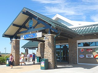
Lawnton is an unincorporated area and census-designated place (CDP) in Swatara Township, Dauphin County, Pennsylvania, United States. The population was 3,813 at the 2010 census. It is part of the Harrisburg–Carlisle Metropolitan Statistical Area.

<span class="mw-page-title-main">Londonderry Township, Dauphin County, Pennsylvania</span> Township in Pennsylvania, United States

Londonderry Township is a township in Dauphin County, Pennsylvania, United States. The population was 4,890 at the 2020 census.

<span class="mw-page-title-main">Lower Paxton Township, Pennsylvania</span> Township in Pennsylvania, United States

Lower Paxton Township is a township of the second class in Dauphin County, Pennsylvania, United States. The population was 53,501 at the 2020 census. It is the most populous municipality in Dauphin County, exceeding that of Harrisburg, the state capital, and the 13th most populated municipality in the state.

<span class="mw-page-title-main">Lower Swatara Township, Pennsylvania</span> Township in Pennsylvania, United States

Lower Swatara Township is a township in Dauphin County, Pennsylvania, United States. The population was 9,557 at the 2020 census. Harrisburg International Airport and Penn State Harrisburg are located within the township. It shares a ZIP Code with the nearby borough of Middletown, and all locations in the township have Middletown addresses.

<span class="mw-page-title-main">Rutherford, Pennsylvania</span> Census-designated place in Pennsylvania, United States

Rutherford is a census-designated place (CDP) in Swatara Township, Dauphin County, Pennsylvania, United States. The area is also known as Rutherford Heights. The population was 4,303 at the 2010 census, an increase over the figure of 3,859 tabulated in 2000. It is part of the Harrisburg–Carlisle Metropolitan Statistical Area.

<span class="mw-page-title-main">South Hanover Township, Pennsylvania</span> Township in Pennsylvania, United States

South Hanover Township is a township in Dauphin County, Pennsylvania, United States. The population was 7,200 at the 2020 census, an increase over the figure of 6,248 tabulated in 2010.

<span class="mw-page-title-main">Swatara Township, Dauphin County, Pennsylvania</span> Township in Pennsylvania, United States

Swatara Township is a township in Dauphin County, Pennsylvania. The population was 27,824 at the 2020 census.

<span class="mw-page-title-main">Upper Paxton Township, Pennsylvania</span> Township in Pennsylvania, United States

Upper Paxton Township is a township in Dauphin County, Pennsylvania, United States. The population was 4,014 at the 2020 census.

<span class="mw-page-title-main">Bethel Township, Lebanon County, Pennsylvania</span> Township in Pennsylvania, United States

Bethel Township is a township in Lebanon County, Pennsylvania, United States. It is part of the Lebanon, Pennsylvania Metropolitan Statistical Area. The population was 5,007 at the 2010 census. Fredericksburg is a census-designated place within the township.

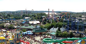
Campbelltown is an unincorporated community and census-designated place (CDP) in Lebanon County, Pennsylvania, United States. The population was 3,616 at the 2010 census. It is located east of Hershey at the intersection of U.S. Route 322 and Pennsylvania Route 117 and is located in the Harrisburg metropolitan area.

<span class="mw-page-title-main">North Londonderry Township, Pennsylvania</span> Township in Pennsylvania, United States

North Londonderry Township is a township in Lebanon County, Pennsylvania, United States. It is part of the Lebanon, PA Metropolitan Statistical Area. The population was 8,912 at the 2020 census.

<span class="mw-page-title-main">Palmyra, Pennsylvania</span> Borough in Pennsylvania, United States

Palmyra is a borough in Lebanon County, Pennsylvania, United States. It is part of the Lebanon, Pennsylvania Metropolitan Statistical Area. The population was 7,807 at the 2020 census.

<span class="mw-page-title-main">South Londonderry Township, Pennsylvania</span> Township in Pennsylvania, United States

South Londonderry Township is a township in Lebanon County, Pennsylvania, United States. It is part of the Lebanon, PA Metropolitan Statistical Area. The population was 8,763 at the 2020 census.

<span class="mw-page-title-main">Lower Dauphin School District</span> School district school in Pennsylvania, U.S.

Lower Dauphin School District is a midsized, suburban public school district located in central Pennsylvania. The district encompasses approximately 89 square miles (230 km2) and consists of Hummelstown, Pennsylvania, East Hanover Township, Pennsylvania, Londonderry Township, Dauphin County, Pennsylvania, South Hanover Township, Pennsylvania, and Conewago Township, Dauphin County, Pennsylvania. According to 2000 federal census data, the district served a resident population of 22,546. By 2010, the district's population increased to 24,747 people. The educational attainment levels for the district's population were 91.2% high school graduates and 28.2% college graduates. The district is one of the 500 public school districts of Pennsylvania.

References

  1. "Welcome to Derry Township". Derry Township. Retrieved December 16, 2015.
  2. "2016 U.S. Gazetteer Files". United States Census Bureau. Retrieved Aug 13, 2017.
  3. 1 2 3 4 Bureau, US Census. "City and Town Population Totals: 2020-2021". Census.gov. US Census Bureau. Retrieved 12 July 2022.
  4. "Londonderry Township - Dauphin County - Central PA". Archived from the original on 2013-05-15. Retrieved 2013-05-12.
  5. "National Register Information System". National Register of Historic Places . National Park Service. July 9, 2010.
  6. "Geographic Identifiers: 2010 Demographic Profile Data (G001): Derry township, Dauphin County, Pennsylvania". U.S. Census Bureau, American Factfinder. Archived from the original on February 13, 2020. Retrieved December 16, 2015.
  7. "Census of Population and Housing". Census.gov. Retrieved June 4, 2016.
  8. https://www2.census.gov/prod2/decennial/documents/17216604v1p40ch02.pdf [ bare URL PDF ]
  9. https://www.census.gov/prod/cen1990/cph2/cph-2-40.pdf [ bare URL PDF ]
  10. "U.S. Census website". United States Census Bureau . Retrieved 2008-01-31.